

SnowGoose69
-
Posts
15,271 -
Joined
-
Last visited
Content Type
Profiles
Blogs
Forums
American Weather
Media Demo
Store
Gallery
Posts posted by SnowGoose69
-
-
3 minutes ago, binbisso said:
Yup not one model showed it. snowing lightly here. I think Walt Mentioned it in his write up that today's light snow could saturate the column which could help with tomorrow's event.
Dry air is not a huge concern tomorrow in my mind...flow is W-SW through most of the column til tomorrow AM...the problem simply is the trof/system tracking most likely too far south but it would not shock me at all if many stations in the metro have more snow from this than they did the last event, albeit not by a ton but certainly could exceed it by 0.5-1 across the board...2.7 at NYC would not exactly shock me at all
-
 1
1
-
-
4 minutes ago, snowman19 said:
If Dr. Simon Lee is correct and we go into February with a +NAO/+AO due to the latest unfavorable stratospheric and SPV developments we are in big trouble. You will be at the mercy of strong ++ENSO/El Nino induced PAC jet extensions, MJO waves propogating over phases 4-6 with the WPAC warm pool convection and the -PDO. You are not going to sustain -EPO with a Nino this strong and +PNA does no good when you have +EPO/+WPO and no arctic or Atlantic high latitude blocking over the top
Yeah the only place that will be cool is the SE where even in that pattern they'd see their coldest February in like 8 years since without the SER they won't see days of 75-80
-
1
-
-
2 minutes ago, 40/70 Benchmark said:
I still think the MJO will speed up, but we'll see.
The tendency had been since November EPS too weak/GEFS too strong, both too slow but last 2 weeks EPS strength actually was closer to reality and the GEFS was too strong...now both have grossly changed their forecast the last 4 days so who knows now
-
1
-
-
1 hour ago, Franklin0529 said:
Mt Holly bullish
I agree with that, maybe a tad too high in the 3-4 zone up north but the 4-6 is legit given the IVT setup....if that happens its likely areas in there see more than what many models are spitting out in C-SNJ
-
1
-
-
2 minutes ago, Allsnow said:
It’s not going to go totally dormant…
It certainly could, for the majority of winters it generally is a non-factor...it just so happens its been unusually active the last 4-5 years
-
3 minutes ago, jbenedet said:
I think the better argument is if the MJO and forecasted teles are wrong....
If they're right and you bake this into the op runs with that general longwave pattern, it's ugly. Very much like that 6z EPS evolution.
You definitely do not want the GEFS idea today of it re-emerging in 3 to be correct...its better for it to just go totally dormant and do nothing
-
3 hours ago, NEG NAO said:
by that time - we will be mowing our lawns - I bet we have at least a couple 70 + degree days in February..
With a +PNA you won't see anything that warm, it'll just be alot of days averaging 5-7 above normal
-
1
-
-
QPF wise Euro looked like it was gonna go boom but then flat lined
-
2
-
-
34 minutes ago, Stormlover74 said:
Wow href

I generally never used it this far out. I do know its very good on the mean inside 24 usually. I am still surprised to see a mean of 5 and max of 8-10 though
-
4
-
-
6 minutes ago, psuhoffman said:
If it speeds up it certainly would change our prospects for early Feb. There is a correlation with the MJO moving through 7 and the NAO tanking. I don't think that its a coincidence that as guidance started to stall the wave in 6 or barely into 7 that was when the delay in getter the NAO to flip started to show up. But maybe the pattern progression was being rushed before.
I feel as if more members don’t have it stalling today than yesterday, there’s a few more now blasting it through 7
-
The RAP/SREF are showing their usual NW bias at this range...its why I have said if you can pick a spot to be right now I'd go with a Long Branch-Cranbury-Marlboro-South Brunswick line....I think the IVT may set up somewhere between about EWR and TTN in the end based off just past tendency of where these go from 48-60 hours out
-
2
-
-
17 minutes ago, weathercoins said:
Do any medium-longer range models show NAO going negative? Seems like we're staying positive at least a while.
I'm still in the Feb 4-5 MECS camp. This comment will make me famous in two weeks.
Often times in the -EPO pattern you default to the -AO/+NAO idea...we saw that in 93-94 and 13-14 or was it 14-15? I forget...but the EPO heights sometimes can hook NE if the EPO ridge is positioned more east of where the GEFS shows it so you end up with above normal heights over the pole and a -AO but the PV gets shunted into E Canada and extends over Greenland so you get a +NAO. The GEPS sort of shows this idea at 336 hours but its not really a true depiction of what we saw in those 2 winters for large stretches
-
5 minutes ago, SBUWX23 said:
doesnt mean its right. its not the gospel model when it comes to smaller details like what we are looking for with this event.
Its 2 problems the last few years since its recent upgrade is a notable dry bias and also the Op is often over amped with E coast storms from 90-120...in this event since the dynamics are not especially strong its paltry QPF could be right but its sure doing what it so often does on QPF relative to other models
-
1
-
-
2 minutes ago, kat5hurricane said:
No, the last 2 winters is not the norm. I grew up in the late 80s and 90s and never experienced back to back winters like this. The snow drought we've been through is unprecedented and now we have people (even a meteorologist mind you) saying that it normally takes a miracle to get snow around here. Lets gain some perspective, what we've seen the last 2 years is not the norm. Even in bad years, we usually still get double digits.
96-99 was insanely bad...that said, 96-97 was a great winter for areas say north of the PA/NY border, we simply got very unlucky with a few setups here, 97-98 98-99 were horrendous though...remember that the 5 boroughs had no Winter Storm Watch issued at all from late March 1996 til 12/28/00....the January 2000 event would have had one issued but due to the model issues the area went straight to a warning...to go that long where at 24-48 hours no storm was going to obviously produce 6 inches or more of snow or 0.25 inches of ice is an impressive run
-
3
-
-
1 hour ago, wdrag said:
12z/17 RDPS gives me pause... might just be a waffle less but I can't go overboard on expectations. Take what we can get
Its sort of funny how it was most consistent model with this past event but its been in my mind the most inconsistent with this one by a wide margin. The NAM/Euro have been most consistent, albeit snowing different ideas but they've bounced around the least run to run
-
1
-
-
2 hours ago, 40/70 Benchmark said:
GEPS is the same general theme and the GEFS is more of a gradient pattern.


That has gotta be the worst +PNA/-EPO pattern I ever saw lol....I am not even sure if that technically qualifies as a +PNA but basically all the numerical GEFS have it as positive in that period. If you wanted to draw a map of how a +PNA/-EPO/neutral NAO/AO could screw you over, thats about as close as it gets.
-
1
-
 1
1
-
-
Just now, brooklynwx99 said:
can't tell you how many times I've seen NYC in the bullseye at 60 hours out for it to hit CT
Yeah, in this case though I fear it could shift back south slightly, not really much room for this whole thing to come much further north really. And if it somehow did if confluence over SE Canada weakened we'd probably get more WAA snows from the S/W anyway. If you want any snow now you ideally probably wanna be in roughly the NYC corridor down to CNJ. North or south of that things can probably go wrong more so
-
3
-
-
3 hours ago, 40/70 Benchmark said:
Noted, but I'll hedge against that. The progression of the MJO has been underplayed all season.
Sure enough today a few more GEFS members try blasting it past 6 through 7, the EPS effectively kills the wave in 6 which I said is fine too because then you probably just revert into a typical Nino February state
-
Usual rule with IVTs they go north late, not a surprise the last 24 hours we now see it focusing closer to NYC than down in the MA as it initially was
-
4
-
-
The RGEM looked way better aloft early but it did not translate through the whole run...it more or less was just a bit faster than 18Z but not a huge difference. The ICON was better but it waffles every run
-
3 minutes ago, MJO812 said:
SREF mean is in upstate NY lol
Always overamped...I glanced and it 2-3 days back for today and it did have heaviest snows in like NE PA and Monticello sure enough and it was like 80 miles too far NW
-
10 minutes ago, SBUWX23 said:
This is crap?
It's not a ku but this isn't necessarily crap
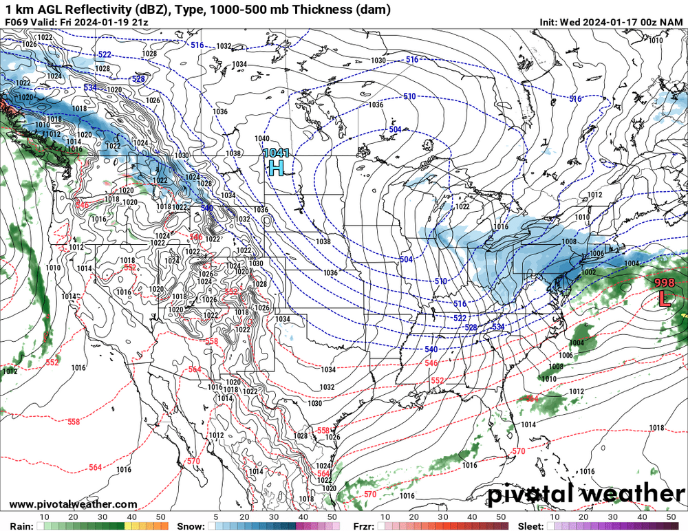
Its got a flukey secondary surface reflection though in the IVT off NJ...18Z RGEM had that too and I think both runs overdid QPF as a result....it can happen though, its just hard to assume at 80 hours out it does but little surface lows forming within the IVT or along a boundary can tick the QPF up enough to matter
-
16 minutes ago, NorthShoreWx said:
I remember hearing on AM radio shortly after 5pm that it was raining in NYC. My disappointment was muted as I looked out the window at the raging snowstorm that dropped about 15" on Stowe.
I learned that day that Vermont is a much better place for clippers than southern NY.

EDIT: I think you're right. The clipper I am thinking of might have been on the 15th.
It was a Miller B digger that was supposed to re-develop and did not dig enough Models were notorious for blowing those into the middle or even later 90s. They either would over dig the shortwave or just over bomb the surface low too early when the trof reached the MA so we had a ton of overblown snow forecasts that never happened. This one was the latter more so, it did not dig enough and the low tracked overhead. 2/16/97 is the last instance I remember of models botching one, the ETA became a good fail safe at not screwing them up and the Euro began to get increasingly used more after March 93 by the US forecasters so those busts sort of fell off the radar after the early 90s mostly
-
2
-
-
2 minutes ago, Stormlover74 said:
Awful. Forecast of 4 to 8" of snow turned to a heavy driving rainstorm
Nah, that was 12/15 haha, so two screwings in 3 days but the first one we were expected to see nothing though
-
 1
1
-


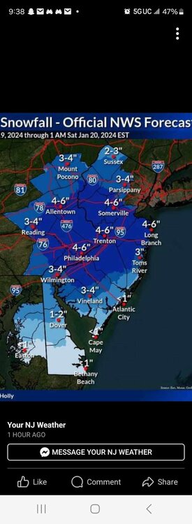
Snow Friday 1/19/24: is it a period of light snow (less than 2"), or is there a chance of a 5" swath in part of the NYC subforum? Event OBS.
in New York City Metro
Posted
I recall one instance where that happened...in last 10 years went from like over CNTRL-LI back to Westchester on all models at 24-36 hours out and ended up in like Long Beach NJ