

jpeters3
-
Posts
736 -
Joined
-
Last visited
Content Type
Profiles
Blogs
Forums
American Weather
Media Demo
Store
Gallery
Posts posted by jpeters3
-
-
2 minutes ago, jojo762 said:
All current convection is mostly north of the high risk area... what’s everyone complaining about?
Nobody is complaining. Experienced professional meteorologists are providing objective analysis of the situation.
-
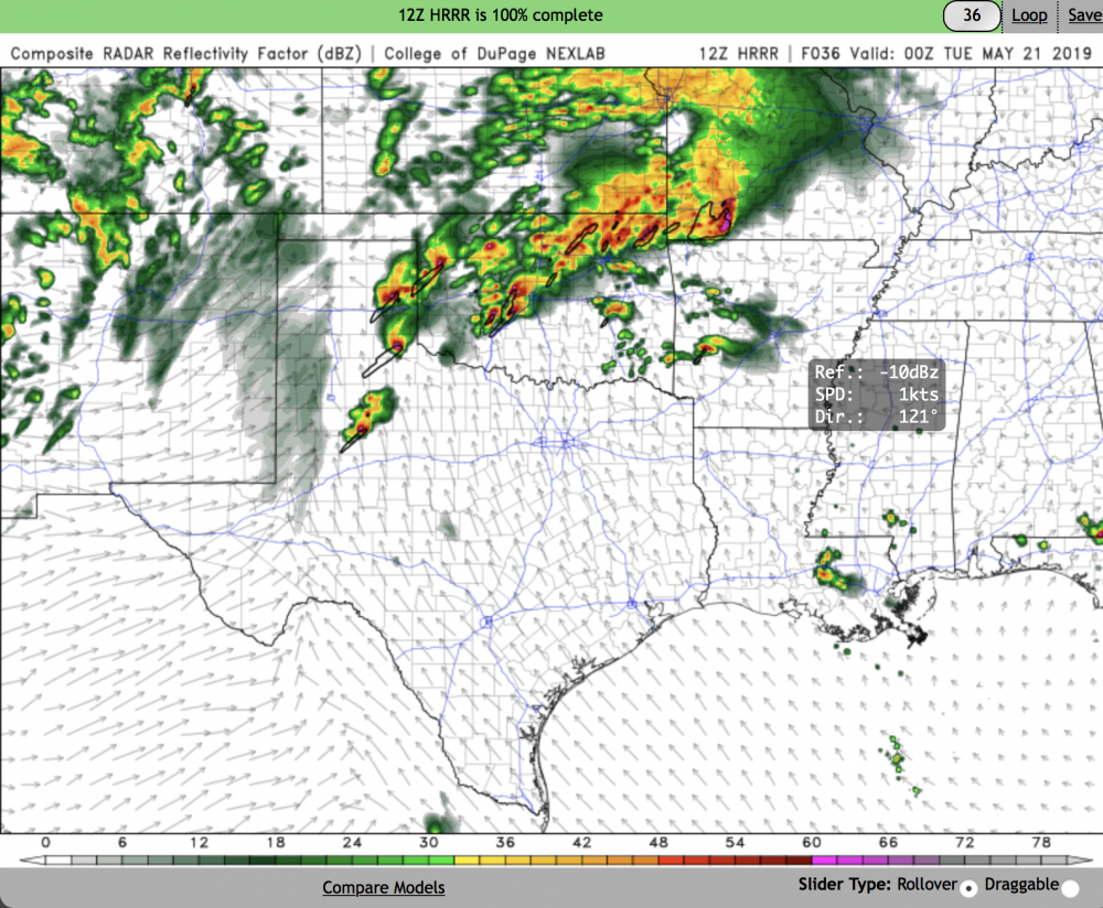
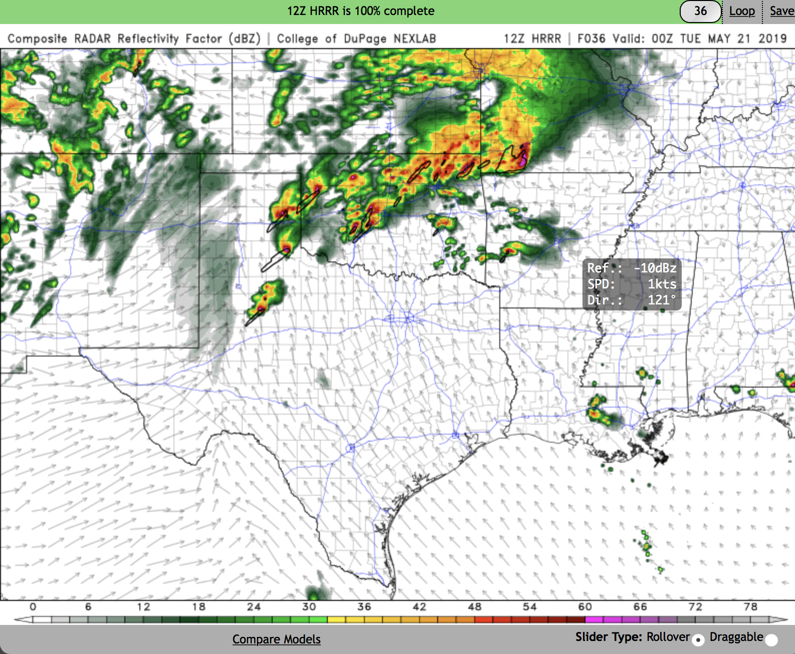
the HRRR solutions are to be taken with a grain of salt at this point. They have consistently (stubbornly) tried to drag all the current panhandle convection quickly into S KS away from the high risk region. Given what we know about bow echo evolutions, this is unlikely for the convection currently entering N OK. Most likely, the current panhandle MCS will track through regions north of I-40 retarding the northward frontal progression. Not sure how this will affect the outbreak potential later, other than to shift it south a tad from what the HRRR suggests.
-
 2
2
-
 1
1
-
-
10 minutes ago, MattPetrulli said:
Godspeed Oklahoma. Type of setup to get a 45 introduced with parameters in place.
Still far too much uncertainty with respect to the convective evolution for such a high % call.
-
1
-
-
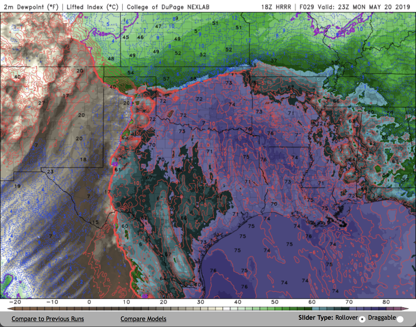
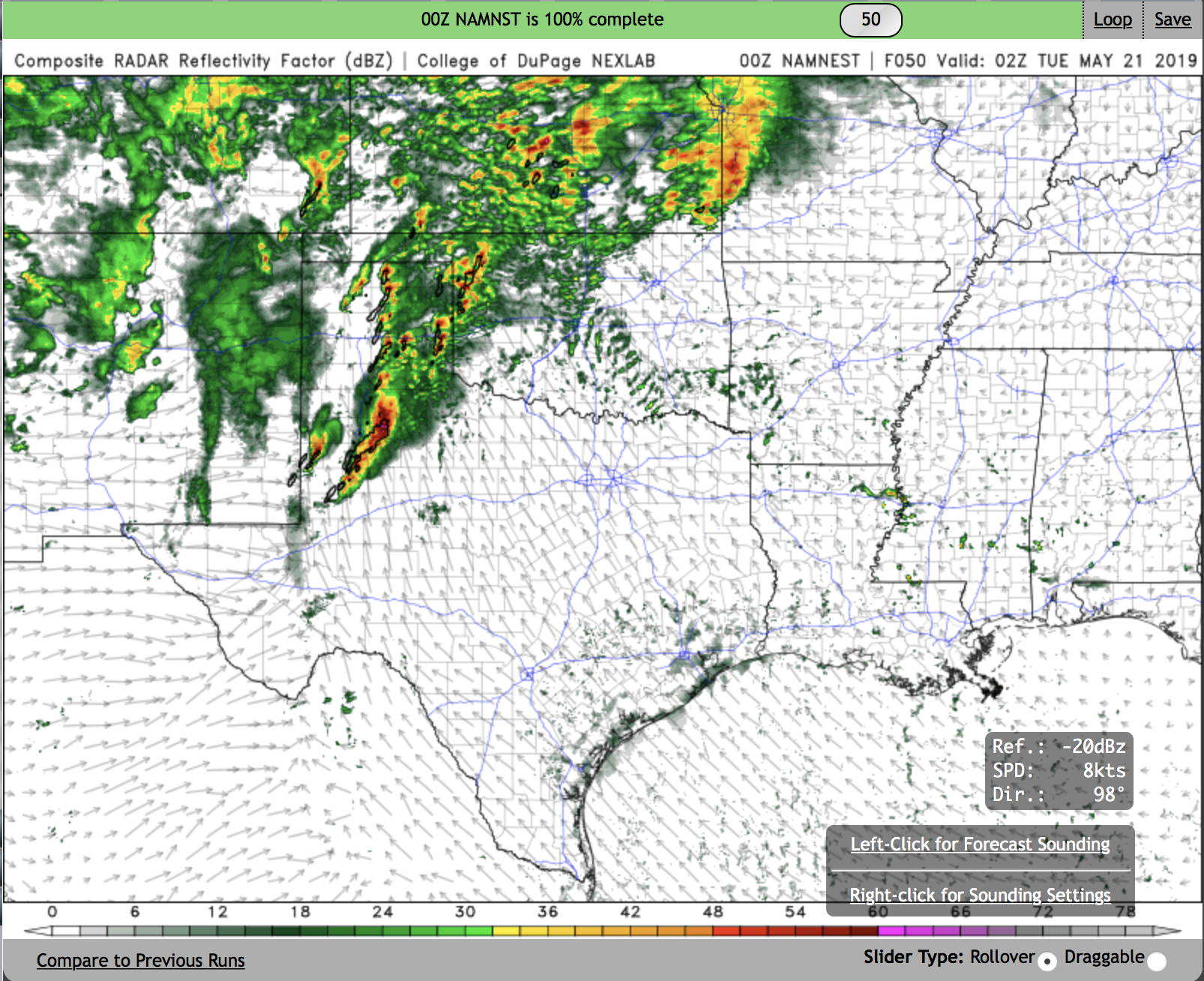
The next few hours are going to be very telling. The bullish HRRR runs have most of the current MCS/precip in the TX panhandle going N into Kansas. There is already a bit more southward development of the MCS there than what is shown in most HRRR solutions. Conversely, the NAM NEST intensifies the current MCS and inundates most of OK with outflow, effectively killing the outbreak potential. The NAM nest seems to aggressive with the MCS development at the current time, but we'll see...
-
1
-
-
As .png.

-
4
-
-
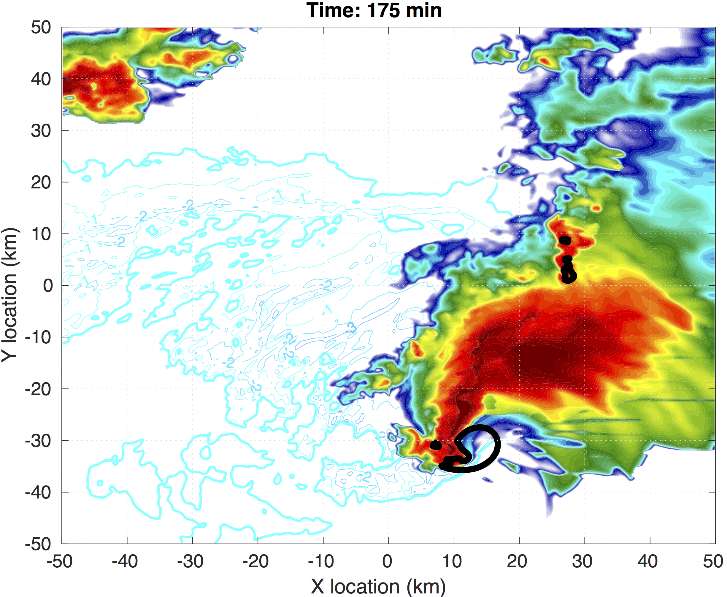
Just for fun, output from a 250 m horizontal grid spacing simulation I ran with one of the insane NAM soundings. Shading is simulated radar reflectivity at 1 km, black outline is 3 m/s 1 km updraft, and blue contours are surface temperature deficit.
-
3
-
-
2 minutes ago, SmokeEater said:
Yup, saw it firsthand. Wasn't gonna put it out yet, but since you did I'll confirm, lol. Parts of W TX, TX Panhandle and W OK.
Sent from my SM-G973U using Tapatalk
Doesn't change the uncertainty, IMO, but probably rightfully acknowledges the possible historic "ceiling" event. If this event goes, it will go big.
-
29 minutes ago, 1900hurricane said:
It's just one solution from guidance, but to have open warm sector, warm front, and dry line supercells like the 00Z HRRR depicts would really be something else. Not sure when the last plains system had a ceiling this high.
You would have to go all the way back to 4-14-12, or even 5-22-11...
-
4 minutes ago, cheese007 said:
Wild to me this could occur exactly 6 years after the last Moore monster
Has it really been 6 years? Time flies...
-
14 minutes ago, OUGrad05 said:1 hour ago, jpeters3 said:I think one of the primary differences between CAMs that show quick upscale growth and those that show a discrete outbreak is the orientation of the dryline in the TX panhandle. The NAM nest surges part of the dryline eastward and ends up with a SW to NE oriented dryline, which is close to parallel with storm motions. Since storm motion vectors end up parallel to the initiation mechanism, a squall line forms fairly quickly. The HRRR, on the other hand, keeps a more N-S oriented dryline and storm motion vectors are more perpendicular.
Subtle difference but it might end up being a big factor.


Interesting the HRRR is more aggressive than the NAM with pulling the front north.
Could be because of less early day convection along the front in the HRRR
-
I think one of the primary differences between CAMs that show quick upscale growth and those that show a discrete outbreak is the orientation of the dryline in the TX panhandle. The NAM nest surges part of the dryline eastward and ends up with a SW to NE oriented dryline, which is close to parallel with storm motions. Since storm motion vectors end up parallel to the initiation mechanism, a squall line forms fairly quickly. The HRRR, on the other hand, keeps a more N-S oriented dryline and storm motion vectors are more perpendicular.
Subtle difference but it might end up being a big factor.-
2
-
-
40 minutes ago, bjc3395 said:
At this point - glancing at summary of 12z guidance... I think so long as we don’t get a warm sector crushing MCS... this is bound for a borderline historic outbreak of tornadic supercells. I know that’s crazy to call >24 hours in advance, and I’m by no means saying Dixie level historic. But for plains events, I think we are headed for something very high end.. bordering on history making. CAMs are not built nor able to properly resolve discrete, propagating supercells.. this could easily be a long duration tornadic supercell event across E TX PH into W and C OK, and NW Texas. TTU WRF and NCAR ensembles show a strong signal for discrete modes maintained well after dark - into 5z. Again.. the CAMs you can access for free on pivotal.. especially the 3km NAM.. are not going to resolve tornadic supercells or a discrete fashion for long.
Personally this looks like a pretty prolific event - but the uncertainties as mentioned above preclude a high risk until perhaps even the 10 am update. But I think this is shaping up to be a memorable, long-duration tornado event.
I wouldn't discount the CAM solutions as much as you suggested. CAMs generally do a good job of physically resolving the conditions related to the initiation and maintenance of MCSs (this is supported by research). It is possible that there are subtleties of the dynamics/thermodynamics that the model is capturing that are difficult to pick out of soundings.
-
16 minutes ago, snowlover2 said:
Moderate risk remains.

I think this discussion hits the forecast problem on head. There will probably be tornadoes, and even some strong ones. Details of the outbreak depend on timing of MCS development at various points through the day. If there is no (or weak) early day MCS, and evening activity can remain discrete, we'll probably see a historic outbreak. If not, tornado coverage will probably be more sporadic. If CAMs keep the current trends, I probably wouldn't go with day 1 high risk (at least early tomorrow) given the uncertainty.
-
FWIW, the 12 UTC HRRR is pretty much all discrete storm mode.
-
3
-
-
12 minutes ago, WhiteoutWX said:
Definitely looks messy but I don’t know if I would characterize that look as totally upscale or linear. Looks like line segments with probable embedded supercells. With that environment I’d still think there would be plenty of tornado risk, just maybe not pristine and clean for chasers.
Right. I'm definitely not calling "bust" at this point, or even saying this won't be a high-end historic outbreak. I just think the upscale growth potential, and/or the potential for mixed storm modes **might** keep this from being a historic tornado outbreak. But it might not... Hard to tell at this point.
There will almost certainly be tornadoes somewhere, and probably a few EF-2 + tornadoes.-
1
-
-
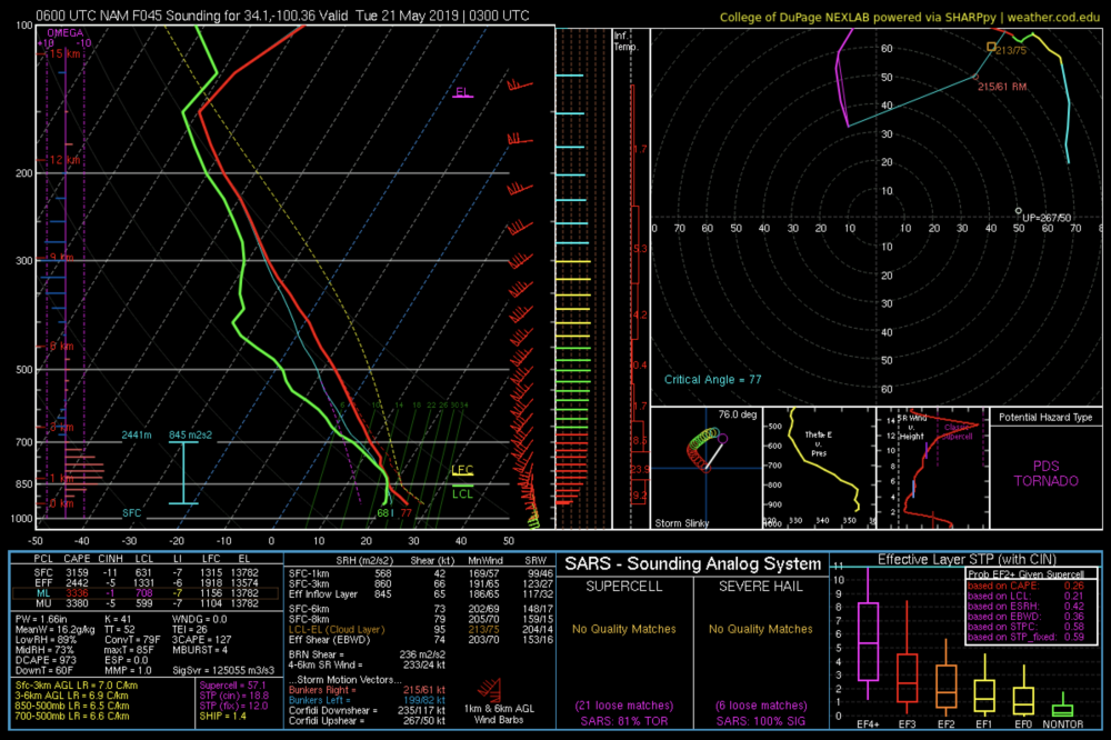
Another crazy eye candy sounding from the NAM at 03 UTC. STP of 19..., 0-3 km SRH of 860 J/Kg.
-
0000 UTC CSUWRF (GFS based) shows quite a bit of early-day convection through the panhandle and OK (this generally agrees with the GFS solutions), along with widespread upscale growth by 03-04 UTC. Some notable UH streaks throughout the region, but this early CI scenario would substantially reduce the warm front risk.
CSUWRF: http://schumacher.atmos.colostate.edu/weather/real_time_wrf/radar_1km_4km/anim.php?
SPC outlooks have harped on the lack of synoptic scale forcing as a factor in keeping cells discrete; however, with such saturation at low levels, it doesn't take much lift to get parcels to their LFCs and not much large-scale ascent is needed to make widespread CI, and the large CAPE and relatively moist mid-level environment in soundings will readily facilitate intense cold pool production and upscale growth.
-
9 hours ago, bjc3395 said:
In my honest opinion, what sets this apart from the 4/13 "bust" is a prominent focus for surface-based convective initiation: the dry line. If you had a surging dry line into eastern TX with favorable shear orientation, I imagine that day plays out much differently.
Instead we didn't exactly have that and storms were initiating but not exactly well-rooted into the surface, nor organized. I think that is a key difference, and the CAMs across the board are depicting varying solutions that all kind of converge on a mixed-mode severe weather outbreak by/after 00z. Agree that a day 2 high is too much. But don't think a day one high is out of the question yet.
Threat for supercells producing significant or violent tornadoes should carry well into dark with the strong theta e advection. Boundary layer stabilization should be offset some.
I should probably stop calling 4-13 a "bust," since it verified in terms of SPC D1 probabilities. I guess the reason I think of that event as a "bust" is because it looked to have high-end potential 1-2 days before, but a high end event never came to fruition.
-
FYI, the 00 UTC initialized CSU WRF is another model to look at, available here:
http://schumacher.atmos.colostate.edu/weather/csuwrf_4km.php
This is run with the GFS (rather than the NAM) as ICs and LBCs. Tonight's run should be available soon.
-
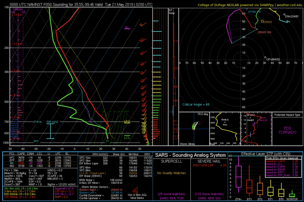
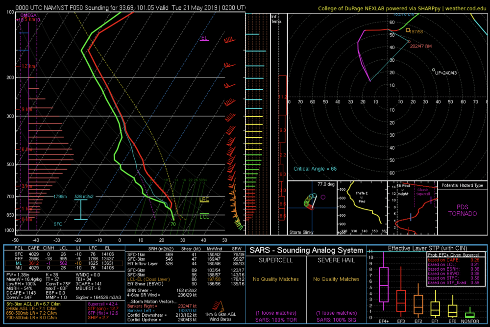
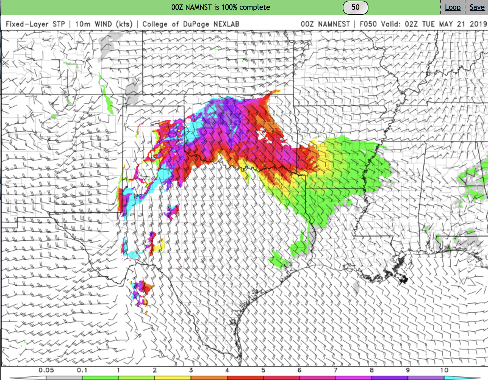
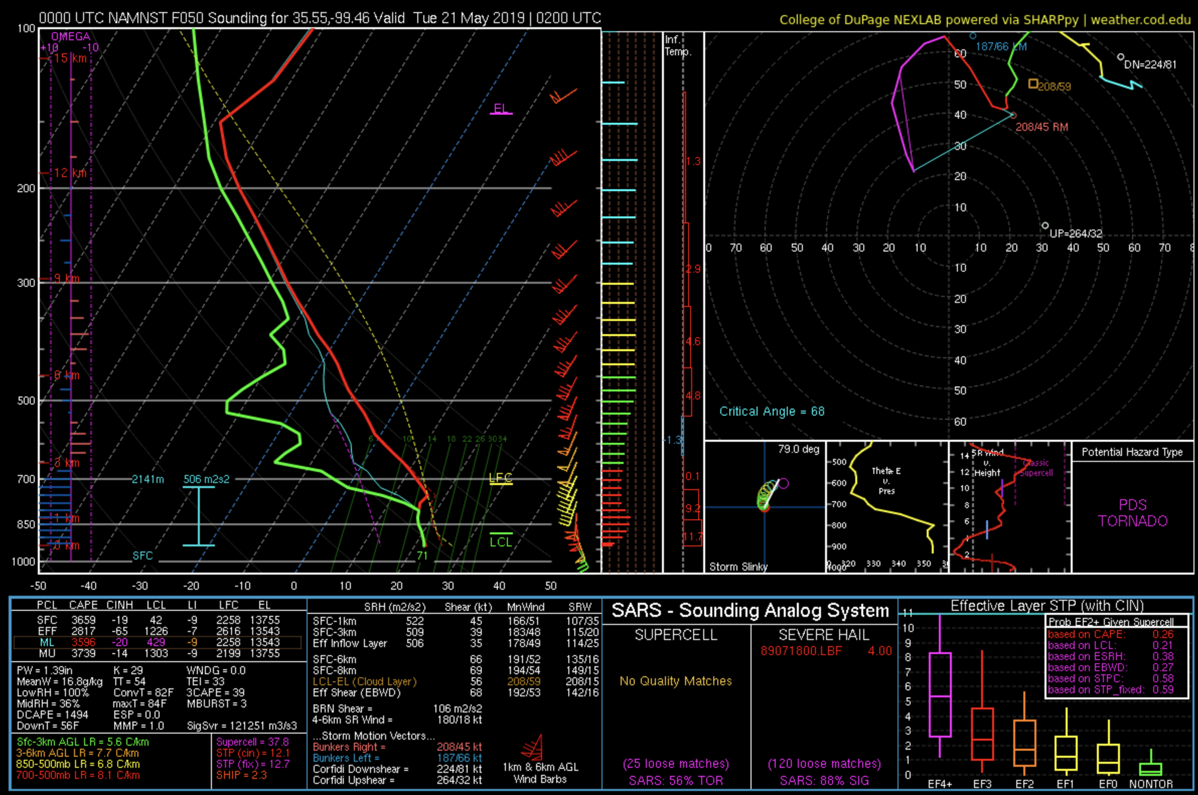
00 UTC NAM NEST shows a tornado outbreak, albeit a brief one. CI is between 22-00 UTC, and then upscale growth pretty quickly follows by 3-4 UTC.
Simulated radar shows numerous discrete cells with high UH at 02 UTC. Widespread STP > 10 in the region where cells initiate. I attached two forecast soundings: one in OK near the northern discrete cells and one in the TX panhandle near the southern group of cells. Both profiles are, needless to say, impressive.
I'm still curious about the deep low-level saturated layer shown in the NAM and NAM nest. This may be a result of strong low-level ascent associate with warm air advection earlier in the day, though warm air advection ramps down into the afternoon. This same feature was present in soundings from the 4-13 event, which turned into widespread messy/grungy convection in the MOD risk region. Really, the feasible only bust scenario is widespread junk and/or upscale growth that happens too quickly. I wouldn't discount this scenario, and it's certainly enough to hold back a day 2 High risk. That sort of call really needs close to 0 uncertainty in day 1, and I don't think we're anywhere close to 0 uncertainty right now.
If we do manage to get discrete cells, they are going to produce numerous ground wedges and ground scraping mesos, in the style of gulf mega outbreaks.


-
1
-
-
Currently progged to be a bit more deep layer shear (0-6 km ~ 65-75 kt) than the 4-13 gulf coast event, which could help keep things discrete for longer.
-
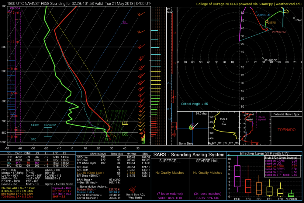
You do, however, have to admire these eye candy NAM NEST soundings after dark near the dryline. Somewhat capped, but 45 kt of 0-1 km shear, and 532 J/kg of 0-1 km SRH. Effective layer STP of ~ 15. I have never seen anything like this in a forecast.
-
19 minutes ago, DanLarsen34 said:
I’m starting to get a bad feeling about Monday. This has very high-end potential.

There is certainly *potential,* however, the largely uncapped and nearly saturated low-level environment certainly makes the "grunge mode fail" a possibility. Think about Apr 13 of this year. Very high end parameters were forecasted over a large regions, but the models also had this similar nearly-saturated low-level environment. That event largely busted in the MOD risk region because of widespread crapvection.
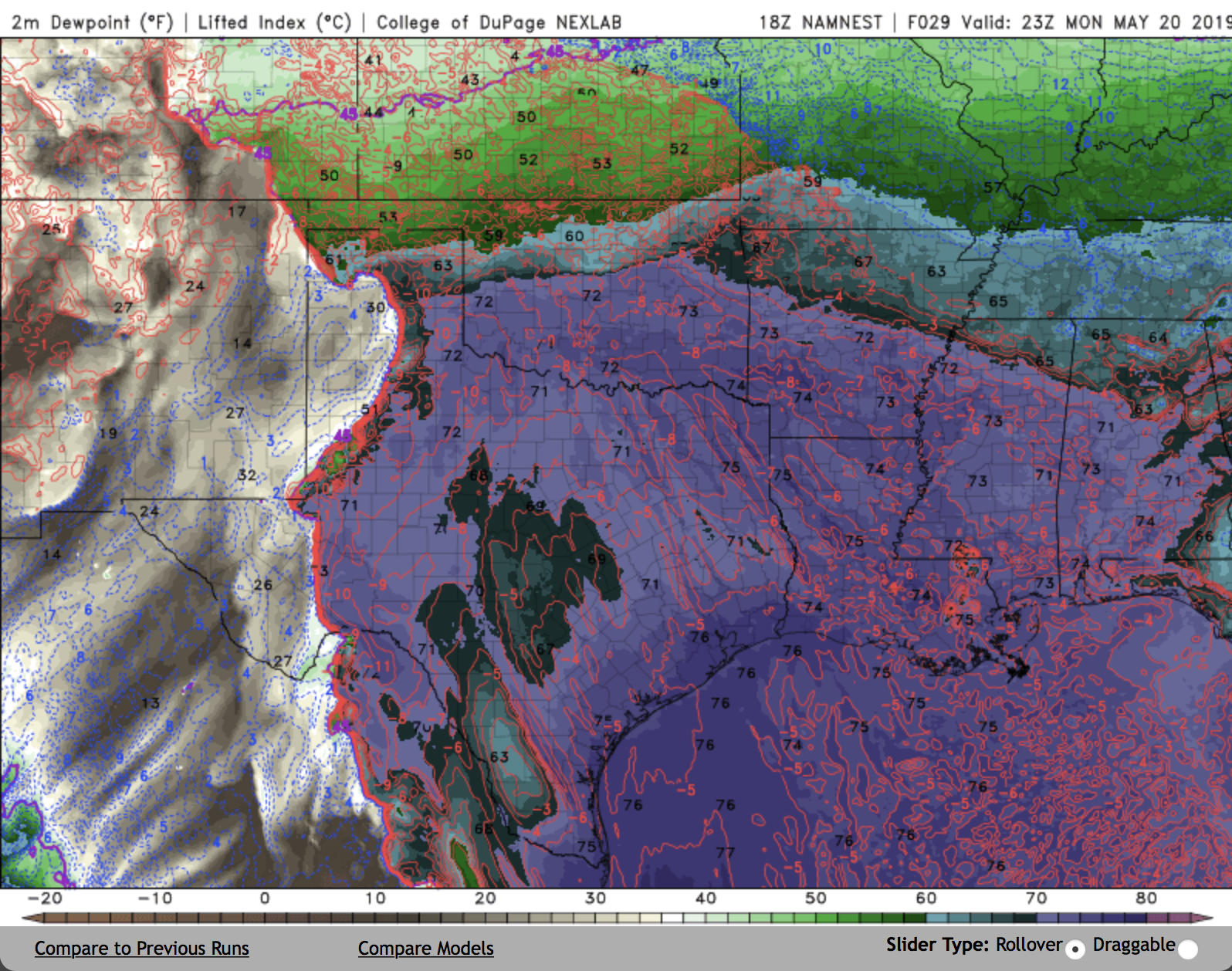
The 18Z NAM NEST shows a mix of both possibilities. There are some discrete cells in the TX panhandle at 00Z, but they quickly grow upscale.
There will probably be at least a few tornadoes, but I'm not sold on a major outbreak just yet. I'd like to see some additional convection allowing guidance.-
1
-
-
DDC already reports EF-3 damage from one of last night's tornadoes near Minneola.
https://www.weather.gov/ddc/Meade_to_Stafford_Tornado_May_17_2019


Mid to Late May 2019 Severe Threats
in Central/Western States
Posted
Agreed with your assessment 100%. I think we need to view these HRRR solutions cautiously, given the northward bias in the portrayal of current activity.