

jpeters3
-
Posts
736 -
Joined
-
Last visited
Content Type
Profiles
Blogs
Forums
American Weather
Media Demo
Store
Gallery
Posts posted by jpeters3
-
-
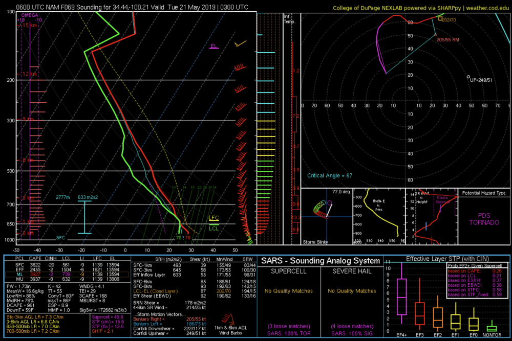
Plenty of extreme soundings in the NAM near the warm front and triple point at 00Z, and then down the dryline a tad later. I'm skeptical at this point as to whether these extreme environments will come to fruition given that the GFS shows a blowup of a mess of convection earlier in the day that inundates the triple point and warm front. However, the GFS environment out in the less contaminated warm sector is still fairly impressive. I'd say Monday has as much potential...
-
Just for fun, this is a NAM forecast sounding near the dryline at 03Z on Monday night/Tuesday morning.
-
1 minute ago, Wmsptwx said:
I think it was even lifted before Kinsley luckily.
yeah i think you're right
-
8 minutes ago, Indystorm said:
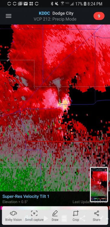
Large tornado still on the ground in Kansas....Larned population 4054........Great Bend 15344
i doubt there is still TOG based on radar presentation
-
Just now, crownweather said:
But now we're going to have others trying to intercept on foot. The reason will be, "If Reed did it, I can too." sigh.
ugh. he got really lucky that didn't turn out worse...
-
 1
1
-
-
new circulation
-
3 minutes ago, crownweather said:
Give him props for what?? Being an idiot? Sure, I'll give him props for that. This is why storm chasing has such a stigma attached to it. You can storm chase without being an idiot or being a hazard to yourself and others.
fortunately for him, it was pretty weak (judging by the fact that he survived in the video).
-
So the VORTEX SE teams that are launching sondes near college station are finding much more CIN and less CAPE than what the HRRR/RAP/MESO analysis are showing...
-
1
-
-
I'll agree with Quincy that the prevalent low-level saturation that has shown up in most convection allowing models makes me every so slightly concerned. On the other hand, there isn't extremely strong WAA/synoptic ascent through the warm sector. Also agree that low-level lapse rates could be a tad steeper.
-
Just now, Quincy said:
SRH was more impressive (than forecast for tomorrow) over a large chunk of Louisiana on 4/2/17. That being said, each outbreak is different.
The region of best instability that day was much further south, and predominantly south of the crazy hodographs in central and northern LA, so i don't think the comparison is entirely fair. Somewhat better overlap between great low-level profiles and instability projected for tomorrow tomorrow.


-
1 hour ago, Superstorm93 said:
I do agree that overall storm mode is still somewhat questionable for tomorrow, but the magnitude of effective shear we have available is pretty astounding. Even if things congeal a little too quickly during the course of the afternoon, we'll definitely have to watch for embedded strong mesocyclones. Just the thought of rain-wrapped tors with already poor visibility is pretty unnerving.
(The overlay feature on weathernerds is pretty awesome by the way)
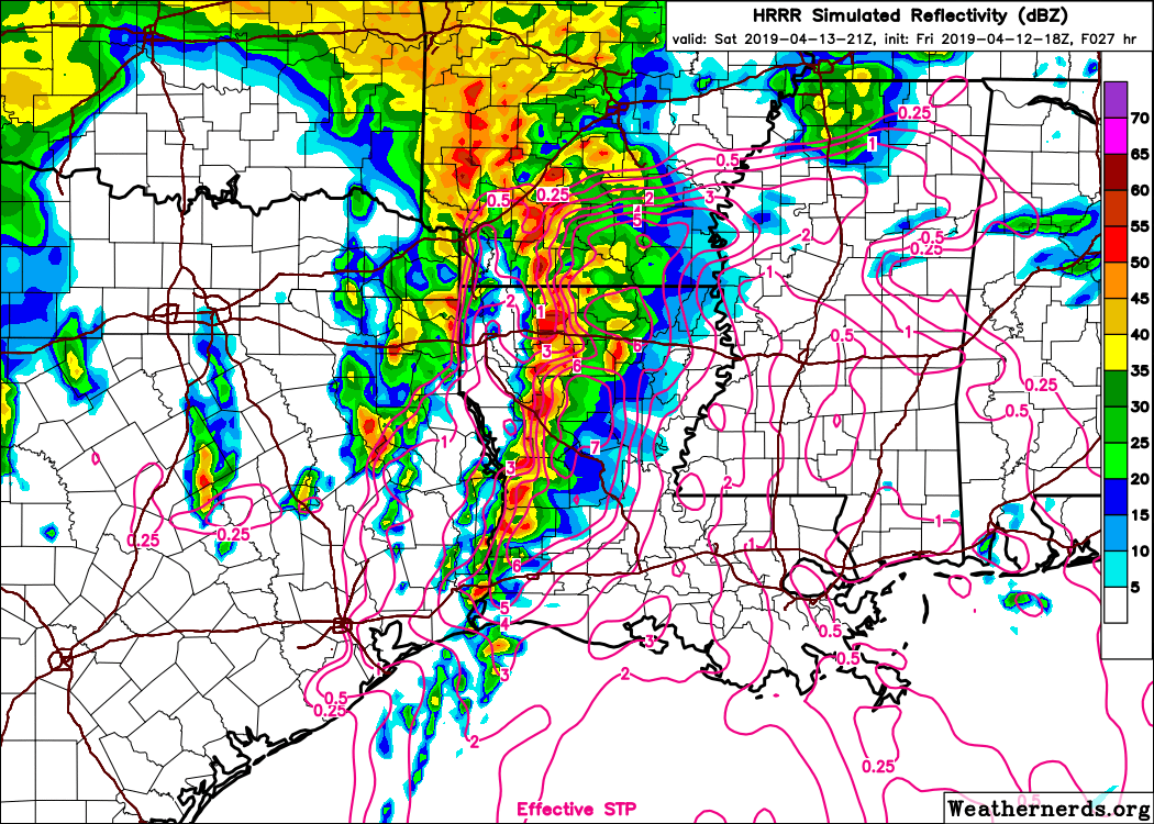
Also good to remember that while 3 km models are commonly referred to as "convection resolving" or "convection allowing," they do not have sufficient resolution to properly portray many attributes of convection. For instance, typical supercell updrafts are on the order of 8-12 km wide. A 3 km model will only have a few grid points across the extent of an updraft. The result of this insufficient resolution is that 3-4 km models tend to produce updrafts and storms that are unrealistically large, and may "unfairly" show more connection/congealment between cells during events like this.
Given the magnitude of the deep-layer shear and what we know about supercell dynamics, what has happened in past similar events, and the fact that there isn't strong synoptic scale forcing overriding the warm sector, I would bet money that we see something more like widespread scattered supercells rather than a QLCS with embedded circulations.-
4
-
-
I'm not convinced that cell interference will be a problem. Firstly, 4-2-17 had slightly weaker deep-layer and low-level shear. The shear magnitudes in these profiles are more akin to 4-27-11. Remember that day didn't have much of a CAPE either, but cells stayed discrete. Stronger deep-layer shear and substantial boundary-perpendicular deep-layer shear should keep things discrete, IMO.
-
1
-
-
2 minutes ago, yoda said:
I expect there to be one on the 0600 DAY 1 OTLK... just saying that I would be a lil suprised to see SPC go HIGH on the 1730 Day 2.
Yeah, I just checked and they have only done it twice. So you're right, it's probably unlikely.
For some reason I thought both 4-27-11 and 5-24-11 were day-2 HIGH, but not the case.
-
3 minutes ago, yoda said:
I think they would wait till Day 1 OTLKs for high risk... I don't remember last time SPC issued a high risk on a day 2 OTLK
It has been a while, but it does happen. Either way, if the current model projections pan out, there WILL be a day 1 HIGH.
EDIT: I just checked and it has only happened twice, on 7-Apr 2006 and 14-Apr 2012, so it's probabilistically unlikely.
-
6 minutes ago, cheese007 said:
Anyone think SPC may go for a high risk?
It is certainly possible, given the general agreement between models on the environmental parameters and discrete convective mode. I would probably go high risk if I were in the forecast seat...
Probably the best looking day 1 setup I've seen since 2012.-
3
-
-
Yeah... so Brett Adair chased this thing with a drone...
Never seen someone do that before.
-
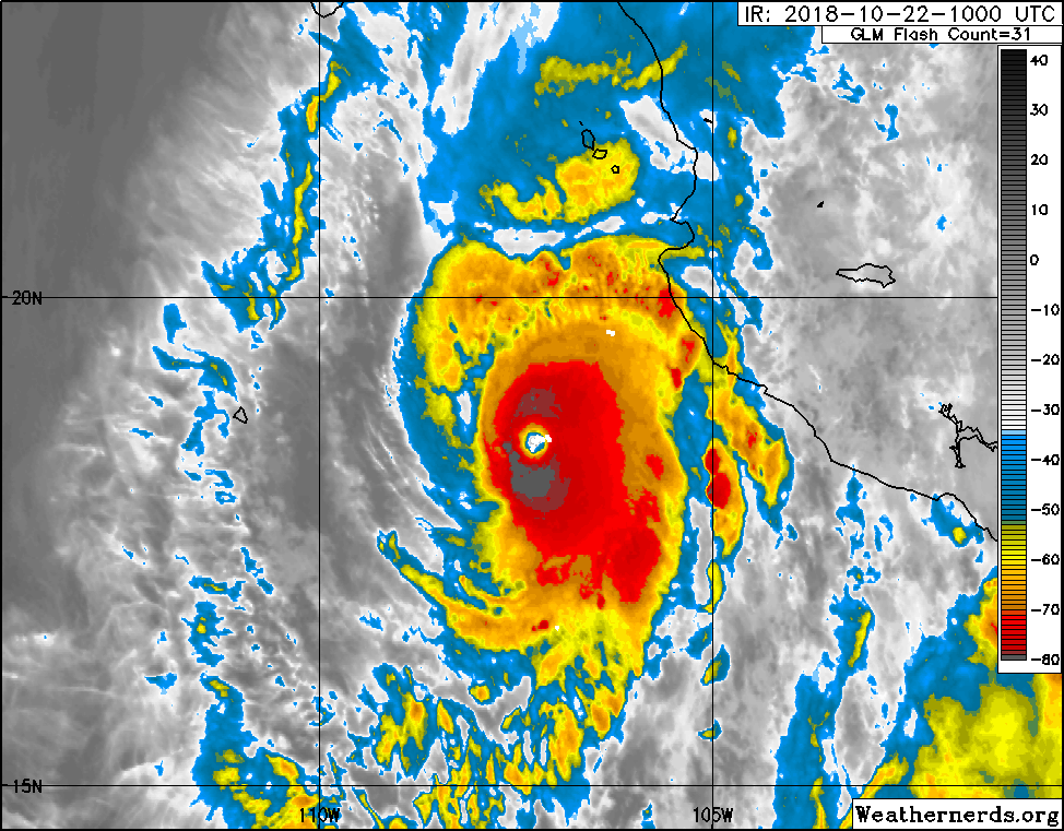
140 kt / 925 hPa cat 5 in the 900 MDT update.

000
WTPZ44 KNHC 221447
TCDEP4

Hurricane Willa Discussion Number  10
NWS National Hurricane Center Miami FL       EP242018
900 AM MDT Mon Oct 22 2018

Willa is an extremely impressive hurricane in infrared and visible
satellite imagery this morning.  The small, but very distinct, eye
is embedded within a symmetric central dense overcast with cloud
tops of -70 to -80 degrees Celsius.  A very recent SSMIS microwave
overpass is the first to indicate that an outer eyewall has formed,
suggesting that an eyewall replacement cycle has started.  The
latest objective T-numbers from UW-CIMSS are T7.0/140 kt, and
subjective Dvorak intensity estimates from TAFB and SAB are 140 kt
and 127 kt, respectively.  Based on these data the initial intensity
has been increased to 140 kt.  An Air Force Reserve Hurricane Hunter
aircraft is currently en route to Wilma and should provide a better
assessment of the storm's intensity by early this afternoon.

Willa is moving northward 6 kt.  The hurricane is forecast to
continue to move northward today around the western flank of a
deep-layer ridge that is located over the Gulf of Mexico.
A short wave trough that is seen in water vapor imagery near 130W
longitude is forecast to deepen as it moves eastward toward Baja
California.  This should cause Willa to turn north-northeastward
tonight, then accelerate northeastward on Tuesday, bringing the
center of the hurricane onshore along the west-central coast of
Mexico Tuesday afternoon or evening.  As mentioned in the previous
advisory, the track guidance is good agreement on the overall
scenario but there are still some notable differences in the
predicted forward speed of the hurricane.  The NHC track forecast
leans toward the faster solutions of the GFS and GFS ensemble
mean, which have been handling Willa's track the best so far.

The environment of low wind shear and water temperatures of 28
to 29.5 degrees Celsius suggest some additional strengthening is
possible but with the evidence that an eyewall replacement has
begun, some fluctuations intensity are possible during the next 12
to 24 hours.  After that time, increasing southwesterly shear is
forecast to induce weakening, but Willa is likely to remain an
extremely dangerous major hurricane when it makes landfall along the
west-central coast of Mexico.  After landfall, shear and the
mountainous terrain of Mexico will cause rapid weakening and
dissipation of the cyclone.

Key Messages:

1. A life-threatening storm surge is expected Tuesday along the
coasts of the Isla Marias, and west-central and southwestern
Mexico near the path of Willa.  Residents should rush preparations
to completion to protect life and property and follow any advice
given by local officials.

2. Everyone in Isla Marias, and within the hurricane warning area
along coast of west-central Mexico should prepare for life-
threatening major hurricane winds associated with the core of
Michael.  Hurricane force winds will also extend inland across the
mountainous areas of west-central Mexico as Willa moves inland.

3. Heavy rainfall from Willa is likely to produce life-threatening
flash flooding and landslides over much of southwestern and
west-central Mexico.


FORECAST POSITIONS AND MAX WINDS

INIT  22/1500Z 19.1N 107.2W  140 KT 160 MPH
 12H  23/0000Z 20.1N 107.2W  140 KT 160 MPH
 24H  23/1200Z 21.4N 106.9W  135 KT 155 MPH
 36H  24/0000Z 23.1N 105.6W   90 KT 105 MPH...INLAND
 48H  24/1200Z 25.4N 102.5W   30 KT  35 MPH...INLAND
 72H  25/1200Z...DISSIPATED

$$
Forecaster Brown
-
Beautiful this morning. Best looking satellite presentation yet.

-
1
-
-
14 minutes ago, Freshgeek said:
Where is SENC now?
Dude that only looks like strong TS force wind damage. I doubt this thing was even a hurricane at landfall ;-).(I'm obviously making fun of the idiot who thinks this was only Cat 2).
-
 2
2
-
-
3 minutes ago, hlcater said:
What does that graphic have it at now?
Looks like 15-20 kt. Look at the top plot, which shows the 200-850 hPa wind difference averaged an area centered on the vortex.But agreed, I think poorly forecasted shear was the culprit today, which inhibited further intensification.
-
14 minutes ago, hlcater said:
There has to be some poorly analyzed shear impacting florence, it's had problems getting anything going to the SW of the core all evening. Until this is fixed, florence should struggle to intensify much.

I'd say it was pretty well analyzed:

For some reason though, it wasn't mentioned at all in the NHC forecast.
-
CDO is starting to look a lot more symmetric. Looks like the brief uptick in shear this AM is abating (per the CIRA product).
Edit: that's odd, it seems to have embedded an older version of the shear product than what is currently displayed on the website. There has been a downtick in the 200-850 hPa shear over the past 6 hours.The latest microwave pass shows improvement in the inner core structure as well:

-
5
-
-
I suspect there might have been a slight uptick in southerly or southeasterly shear over the past 12 hours. There was a bit of an increase (to roughly 15 kt) in shear in the CIRA area averaged product:
Also not the cloud tops to the southeast of the system that are being blown toward the core, rather than parallel to or away from the core, and outflow is a bit restricted on the southern and southeaster quadrant.
-
1
-
-
14 minutes ago, Amped said:
An hour later, GFS takes a 915mb low into Nova Scotia
A bit ironic that the GFS did actually give a somewhat outlandish solution an hour after I made that post.
This is indeed probably an outlandishly low prediction because of unphysical things going on in the cumulus parameterization scheme. My gripe is mainly when weenies look at a surface pressure map and can't understand why a TC moves in a particular direction, and start arguing that the model is doing something unrealistic. On the other hand, the scenario where a very climatologically intense cyclone makes landfall on Novia Scotia is not at all unreasonable given the very high SSTs off the coast, and there comparatively cool air introduced by the trough that descends out of Canada. Quite the recipe for volatile baroclinic instability.-
 1
1
-
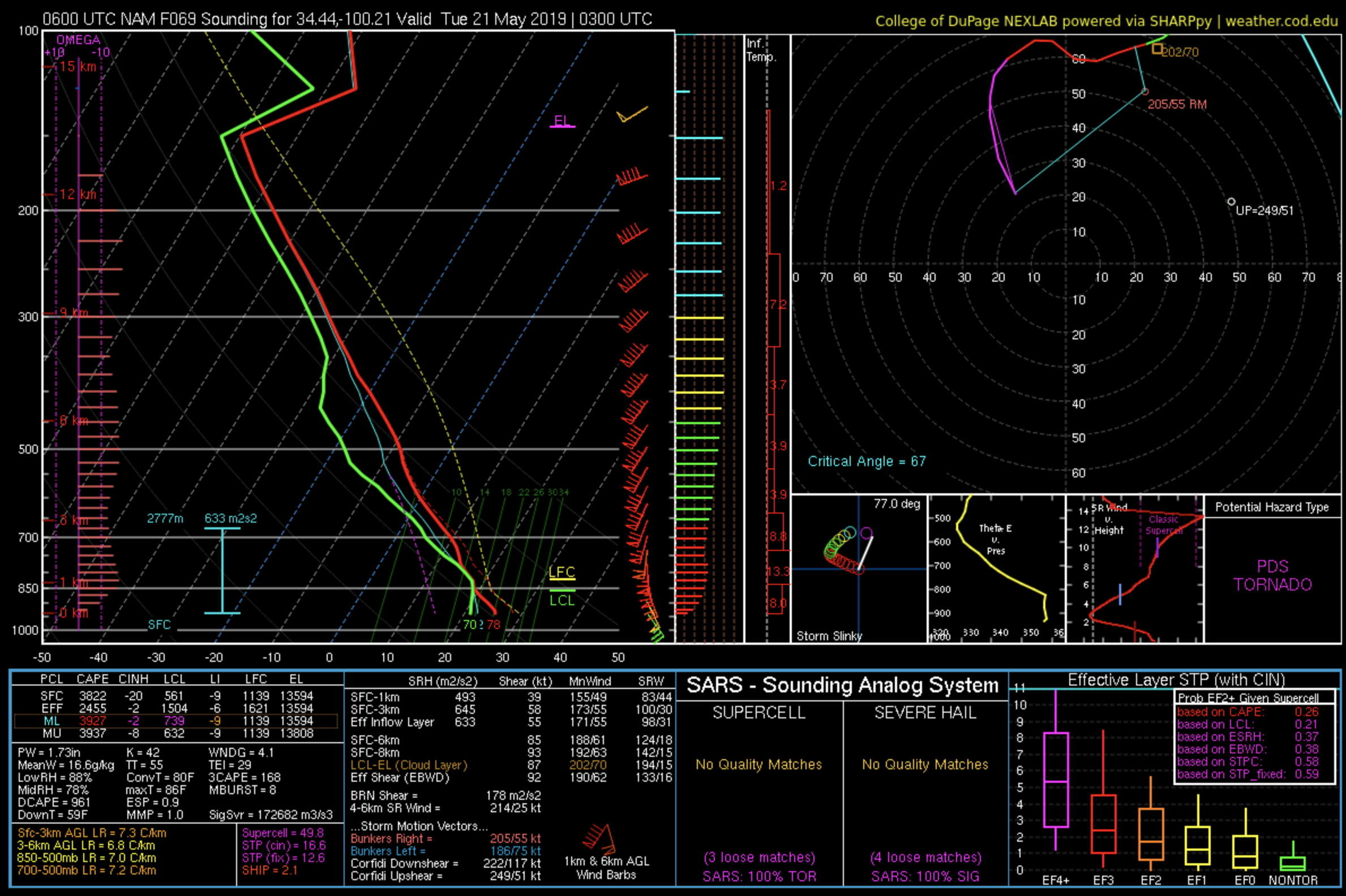

Mid to Late May 2019 Severe Threats
in Central/Western States
Posted
The last frame of the 06Z NAM nest sets up a pretty volatile environment, with earlier-in-the-day-junk confined pretty close to the warm front/triple point.