

Allsnow
-
Posts
23,616 -
Joined
-
Last visited
Content Type
Profiles
Blogs
Forums
American Weather
Media Demo
Store
Gallery
Posts posted by Allsnow
-
-
8 minutes ago, weatherpruf said:
it's a powder out here in NJ. Not wet at all.
2 minutes ago, RU848789 said:As of about 5.50 am the snow band finally petered out and I measured 11.0" for a paltry 1" in the last hour - usually i would kill fire that lol. Could still get another inch over the next few hours but the main event is over. Saw 12" retorted in Readington and plenty of 10+" amounts in CNJ and 9.9" in Metuchen at 5 am which is very close to my 10" at 4.45 am. Really feeling like a once in a lifetime event for a surprise localized major storm and especially getting 2"/hr rates for 5+ hours. Very LES like.
Jackpot!!!!! 11 inches
great event
-
 4
4
-
-
Just now, Ginx snewx said:
Nice thanks for canceling winter really gave us a boost. Enjoy
Up to 8 here and still ripping
-
1
-
 1
1
-
-
4 minutes ago, winterwarlock said:
Somewhere between 5-8 inches out there in Belle Mead NJ
Crushed!!!!
-
2
-
-
Definitely getting close to a foot here with the way the radar looks towards phl
-
7
-
-
Anything in the park?
-
1 minute ago, RU848789 said:
As of 2.15, 5.5" otg so 3"/hr rate last 30 minutes. This is a once in 10 year deformation snow band. It's insanely gorgeous out there... this is almost like lake effect snow. NWS just put out a warning for Middlesex for 4-6" more snow after 2 am and for Somerset, Mercer and Hunterdon for 3-5" more snow after 2 am. That means we could hit 10" here. This reminds me of that incredible inverted trough band of 10" they got at an Eagles game several years ago.
Crazy!!! 5.5 in 2 hours
-
1
-
-
-
I might end up with 10 at this rate
-
1
-
1
-
-
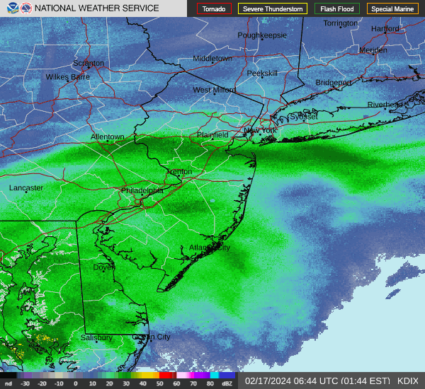
Special Weather Statement
National Weather Service Mount Holly NJ
202 AM EST Sat Feb 17 2024Mercer-Hunterdon-Morris-Eastern Monmouth-Western Monmouth-Somerset-Middlesex-Warren-Lower
...A BAND OF HEAVY SNOW WILL AFFECT HUNTERDON...SOUTHWESTERN MORRIS...SOUTHWESTERN WARREN...NORTHWESTERN MERCER...SOMERSET... NORTHEASTERN MONMOUTH...MIDDLESEX...BERKS...LEHIGH...NORTHWESTERN MONTGOMERY...NORTHWESTERN BUCKS AND SOUTHERN NORTHAMPTON COUNTIES...
At 157 AM EST, a band of heavy snow was located along a line extending from central Berks County, the Lehigh Valley, and upper Bucks County eastward into New Jersey toward Raritan Bay. Movement was east at 15 mph. Snowfall rates of 2 to 4 inches per hour have been observed with this band and roads have become snow covered.
Locations impacted include... Allentown, Reading, New Brunswick, Perth Amboy, Easton, Somerville, Somerset, Edison, Bethlehem, Middletown, Old Bridge, East Brunswick, Bridgewater, South Brunswick, Sayreville, North Brunswick, Carteret, Forks, Middlesex, and Princeton.
This includes the following highways... New Jersey Turnpike between exits 10 and 13. Northeast Extension between mile markers 38 and 62. Interstate 78 in Pennsylvania between mile markers 22 and 76. Interstate 78 in New Jersey between mile markers 0 and 42. Interstate 287 in New Jersey between mile markers 0 and 30. Interstate 176 in Pennsylvania between mile markers 8 and 11. Garden State Parkway between mile markers 113 and 134.
Visibilities will drop quickly to less than a quarter of a mile in this band of heavy snow. A Winter Storm Warning is in effect for portions of the area. Please monitor local media outlets and the National Weather Service for further statements.
Conditions can deteriorate rapidly in winter weather situations. Be prepared for snow or ice covered roads. Slow down and allow extra time when traveling.
TIME...MOT...LOC 0657Z 251DEG 12KT 4050 7412 4053 7467 4052 7540 4039
-
1
-
-
3 minutes ago, RU848789 said:
Unreal
Winter storm warning now!!!! We rippppppp
-
1
-
-
7 minutes ago, RU848789 said:
4" otg as of 1.45 pm so we're at 4"/hr rates the last 30 min which is close to the most I've ever seen. If this somehow keeps up even at "just" 1-2"/hr for a few hours we'll get 8" or more!
Unbelievable. Best rates since Boxing Day 2010
-
1
-
-
1 minute ago, RU848789 said:
Holy crap! Dozed off at midnight with light snow having just started and woke up at 1 am to deathband snow! We havre 2" otg as of 1.15 am which is incredible! Spectacular huge debrief dendrites... ratios must be at least 15.1. 30F.
Absolutely puking snow! Best radar in years
-
1
-
-
3 minutes ago, winterwx21 said:
Wow that's awesome! It looks like you might get 6 while I get 3 to 4 up here.
-
4
-
-
2 minutes ago, winterwx21 said:
You have 3 inches already? Wow. I'm not up to an inch yet here. Coming down good but obviously a huge difference just a few miles to the south.
Flakes are huge! Best snow in years. Easily 2 inches a hour
-
7
-
-
Very heavy snow under this band. 3-4 already
-
4
-
-
Great day for a outdoor hockey game tomorrow at MetLife
-
6
-
-
4 minutes ago, Stormlover74 said:
Yeah at least everyone south of 80 should be in one. And I won't be surprised to see a heavy band north of there
Looks good for our area. We better not loose this heavy band to sw ct haha
-
1
-
-
-
18z euro the same as 12z
-
Icon has .7+ qpf In Monmouth county
-
-
3k looks like euro
-
1
-
-
6 minutes ago, Allsnow said:
Might look close to the euro

-
3
-
-
1 minute ago, Allsnow said:
Nam will be further north this run
Might look close to the euro
-
1
-

Refresher snow & obs between ~midnight and Noon Sat Feb 17 2024
in New York City Metro
Posted
Unbelievable. This will raise this winter a full letter grade for me.