

Allsnow
-
Posts
23,621 -
Joined
-
Last visited
Content Type
Profiles
Blogs
Forums
American Weather
Media Demo
Store
Gallery
Posts posted by Allsnow
-
-
1 hour ago, bluewave said:
I noticed that the MJO 5-6 was much stronger in the Octobers ahead of our snowiest La Ninas since 2010. But two of our three snowiest La Niña winters were still warmer than average like the ones with the weaker October MJO 5-6 and less snowy winters. So not sure why this has worked out for us just since 2010. The 10-11 and 11-12 multiyear La Niña was snowier in 10-11. Then the 16-17 and 17-18 event was snowier in 17-18. This was followed by 20-21, 21-22, and 22-23 which was snowiest in 20-21. It was almost like 20-21 was a weaker and warmer reflection of the stronger -AO and snowy 10-11. 16-17 was less snowy and much warmer than 17-18. But still found a way to produce above average snow. February 2018 was the most extreme daily winter warmth record we ever saw when we hit 80° for the first time. Even if the winter into spring was so snowy.

Thanks. Hopefully some hope for next winter. Great insight
-
 2
2
-
-
42 minutes ago, bluewave said:
Under 15” seasons in NYC before 1990 were usually the result of drier conditions or hostile storm tracks. These days it’s warmer conditions of 38.0° to 41.5° and hostile storm tracks which result in under 15” seasons. Having those two features working in tandem will eventually produce more frequent under 15” seasons. But we will still have opportunities for snowier seasons from time to time like 20-21.
Time Series Summary for NY CITY CENTRAL PARK, NY
Click column heading to sort ascending, click again to sort descending.RankEnding DateTotal Snowfall Oct 1 to Apr 30DJF Average Temperature 1 2023-04-30 2.3 41.0° 2 1973-04-30 2.8 35.5° 3 2002-04-30 3.5 41.5° 4 1919-04-30 3.8 36.6° 5 2020-04-30 4.8 39.2° 6 1901-04-30 5.1 31.7° 7 1932-04-30 5.3 40.1° 8 1998-04-30 5.5 39.6° 9 2012-04-30 7.4 40.5° 10 2024-04-30 7.5 40.3° 11 1989-04-30 8.1 35.9° - 1878-04-30 8.1 33.2° 12 1951-04-30 9.3 36.1° 13 1997-04-30 10.0 37.8° 14 1942-04-30 11.3 32.9° 15 1955-04-30 11.5 33.9° 16 1931-04-30 11.6 33.7° 17 1995-04-30 11.8 37.1° 18 2008-04-30 11.9 36.4° 19 1872-04-30 12.1 29.5° 20 2007-04-30 12.4 36.5° 21 1992-04-30 12.6 37.2° 22 1999-04-30 12.7 38.6° 23 1980-04-30 12.8 35.4° 24 1986-04-30 13.0 33.4° - 1959-04-30 13.0 30.8° 25 1975-04-30 13.1 37.5° 26 1990-04-30 13.4 35.7° 27 1930-04-30 13.6 35.4° - 1900-04-30 13.6 33.6° 28 1929-04-30 13.8 34.7° 29 1950-04-30 14.0 37.6° What made 20-21 so snowy? I remember you said something about the mjo in October being a precursor for that January…
-
1
-
-
Just now, 40/70 Benchmark said:
One thing I have learned to watch for is that bathtub off of Japan during outlook season. I have been doing this a decade, but still have so much to learn....really starting to expand my scope on a gloabl level when seeking out indicators.
I don’t issue seasonal forecasts but I admire the hours of work you put into it every season. Look forward to reading your thoughts this fall. Hopefully, a Nina like 20-21 haha
-
3
-
 1
1
-
-
6 minutes ago, 40/70 Benchmark said:
I'm not sold on strong yet...it could be moderate. ..but with a very active tropical season I think the floor next year is maybe like 1998-1999, which is still a bit better than this year for most.
Funny, you would think I had a great forecast by just eyballing the forecast H5 composite vs reality, but it just didn't translate.
December ended up being a lot worst than everyone thought. You really couldn’t predict that bad of a nightmare from months in advance. January ended up flipping the script but the pac jet ext killed the party. Lately, the jet ext kill any type of winter in the lower 48. It takes weeks to recover now just to have a chance.
-
11 minutes ago, 40/70 Benchmark said:
I am reluctant to gve credit to folks who don't publish a seasonal effort, but I read enough from you and Bluewave to know that you asbolutey nailed the impact of that west PAC warm pool this year. Nice recognition of that. I will also credit snowman for the super El Nino call that eeked out, but I do not agee with him that this season was warm due to El Nino.
Thanks. I thought you did a great job with predicting the very short window of winter this month. My guess was we would get into March with a favorable look but it went to hell fast.
Don’t think much changes next winter outside NNE with the strong Nina. It’s just going to enhance convection where we don’t want it. The Midwest will probably have a huge winter
-
38 minutes ago, MJO812 said:
Mid March onward looks colder. Maybe some snow.
We done! Time for 9 months of humidity and warmth
-
2
-
-
2 hours ago, CoastalWx said:
Actually a nice aftn. Did a bunch of yard stuff today.
-
4
-
-
2 hours ago, CoastalWx said:
I wonder how short next winter will be. Might end after December if we get Nina.
Would be nice to get a Nina to actually give us cold/snow in December.
-
7 minutes ago, 40/70 Benchmark said:
Especially after next year we are going to enter into a stretch of a few years that will not feature much high latitude blocking at all IMO, so the extra tropical Pacific needs to improve.
NNE should Be fine next winter with the Nina. It obviously can’t get any worst than this winter for that area.
We are probably cooked down here if the PAC doesn’t improve
-
3 minutes ago, tamarack said:
Seems like your NJ locale is in the north part. I saw some FB pics a couple days back from where I grew up in northern Morris County, and the snow cover looked about like that 3". Also, the lake where I usually fished was wide open. I don't think the red ball flag (denoting safe ice) was ever flown this year.
We may have a 20° AN day by mid week. Wednesday's average here is 32/9 and 48/35 is a possibility.
We had 2+ of snow cover here in Middlesex County the last 10 days.
-
7 hours ago, RU848789 said:
Deep winter still here in Metuchen. Have had 2+" otg here since last Tuesday (10 days), which is nice. 24.6" on the season, which is more than anyone on the entire NE corridor from VA to Boston - not sure that's ever happened for me in my 30 years here, as we've gotten quite lucky this winter, especially with the amazing 11.25" on Saturday, which, in retrospect, is, I think, the most snow I've ever had over a 5 hour period, as it was just pouring with 4"/hr over one 30 minute period. Top 5 all-time storm for me because of the sustained heavy snow and the huge overperformance relative to forecasts.

Finally our small little town was a local jackpot…
-
2
-
-
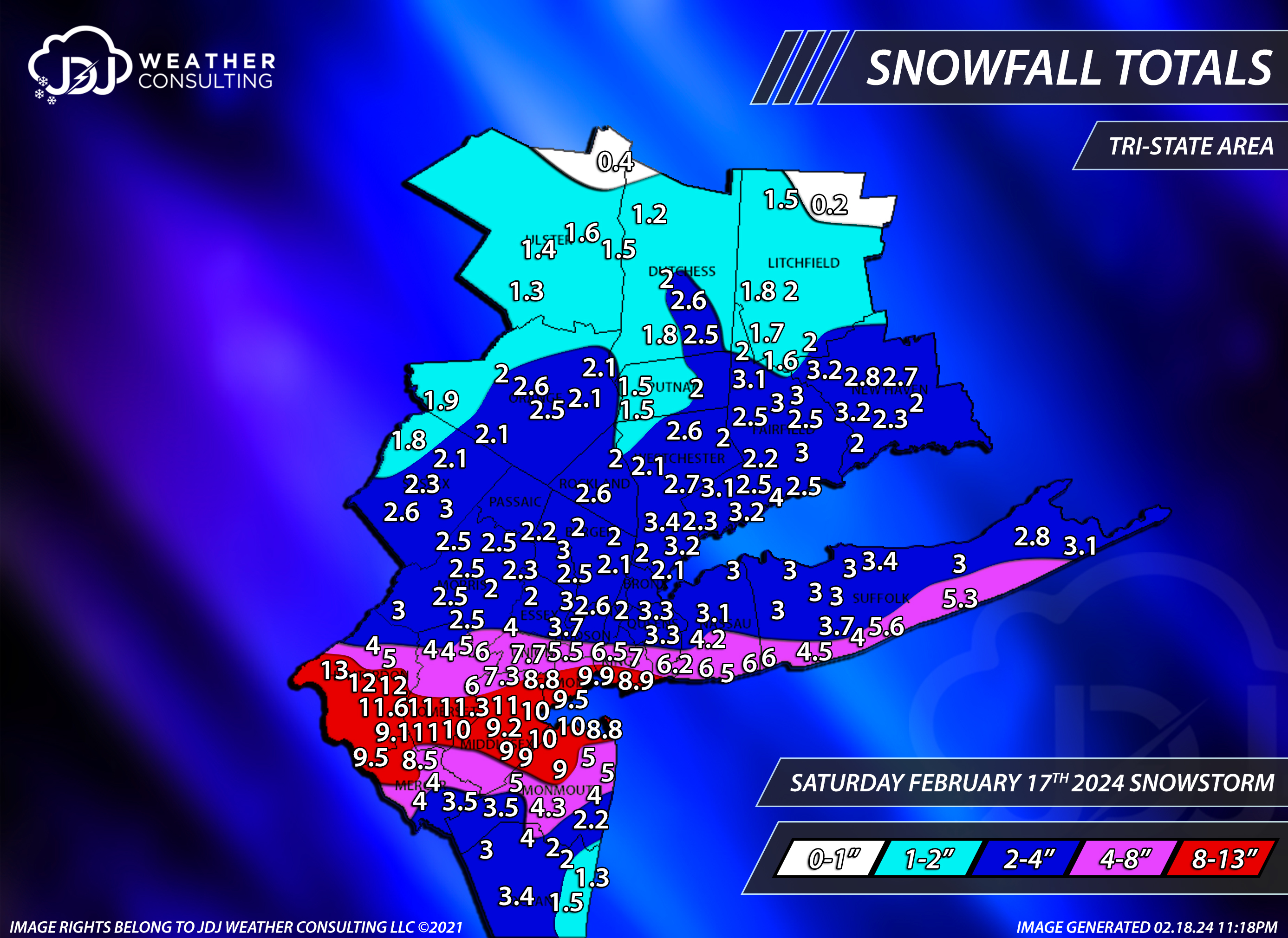
19 minutes ago, The 4 Seasons said:
Nice map, a lot of attention to detail. I'm sure that took a minute if you plotted all those reports by hand.
Rutgers weather climate site maps all of our snow events like this..
-
24” here. C. Two weeks of winter and one storm over 10 inches
-
1
-
-
3 minutes ago, snowman19 said:
I think we’re done outside of some freak, anomalous event which is always a risk every year in mid-late March. Even if we assume the pattern flips at 3/15 (big assumption), at that point, at our latitude, it’s spring climo/sun angle/length of day season. Average highs in the 50’s. The Equinox is only 4 days later and all of the arctic cold is locked on the other side of the hemisphere in Eurasia going into March. We are very likely donzo
Good. Time for a early spring
-
5
-
 1
1
-
-
8 minutes ago, snowman19 said:
LFG! Bring it
-
2
-
-
-
On 2/18/2024 at 11:32 PM, The 4 Seasons said:
Just finished this. Tri-state snowfall totals from this event.
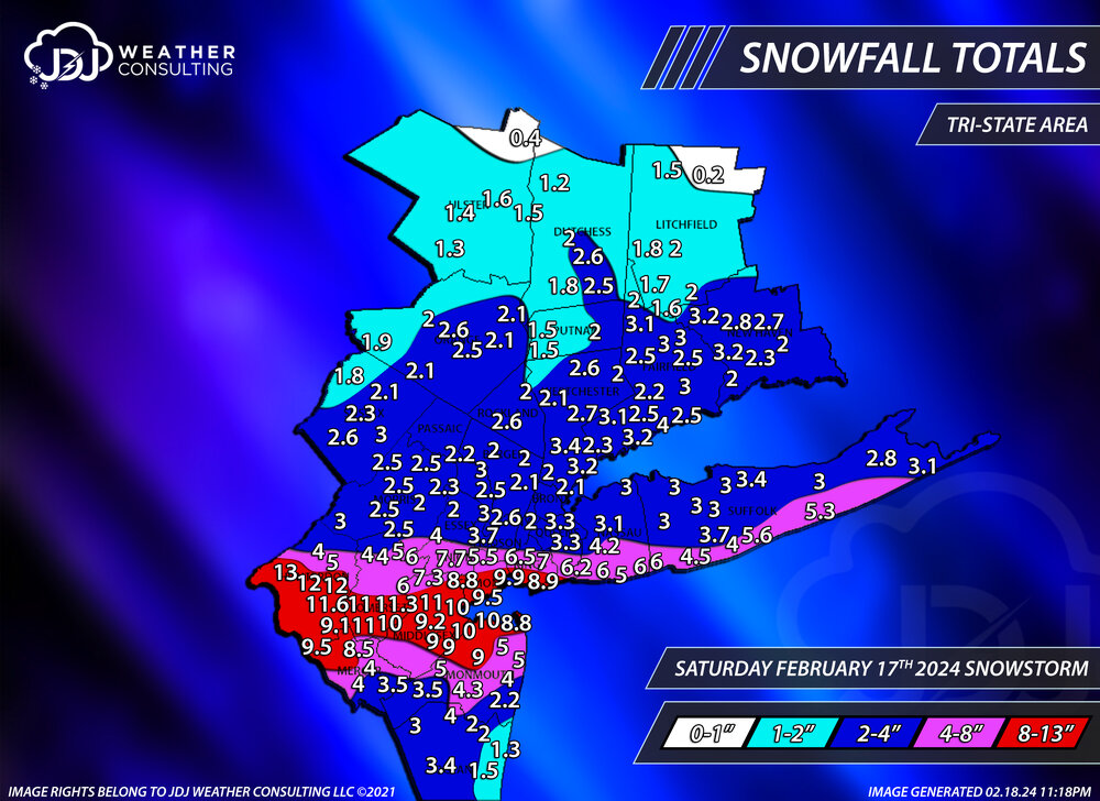
Thank you for sharing in our forum

-
2
-
-
5 minutes ago, jm1220 said:
15.5” for the winter here. Definitely not good since average here is over 30” but a step above total disaster. I still give the winter a D/D-.
We know now that strong Nino won’t be friendly with the warming ocean temps and climate
-
2
-
-
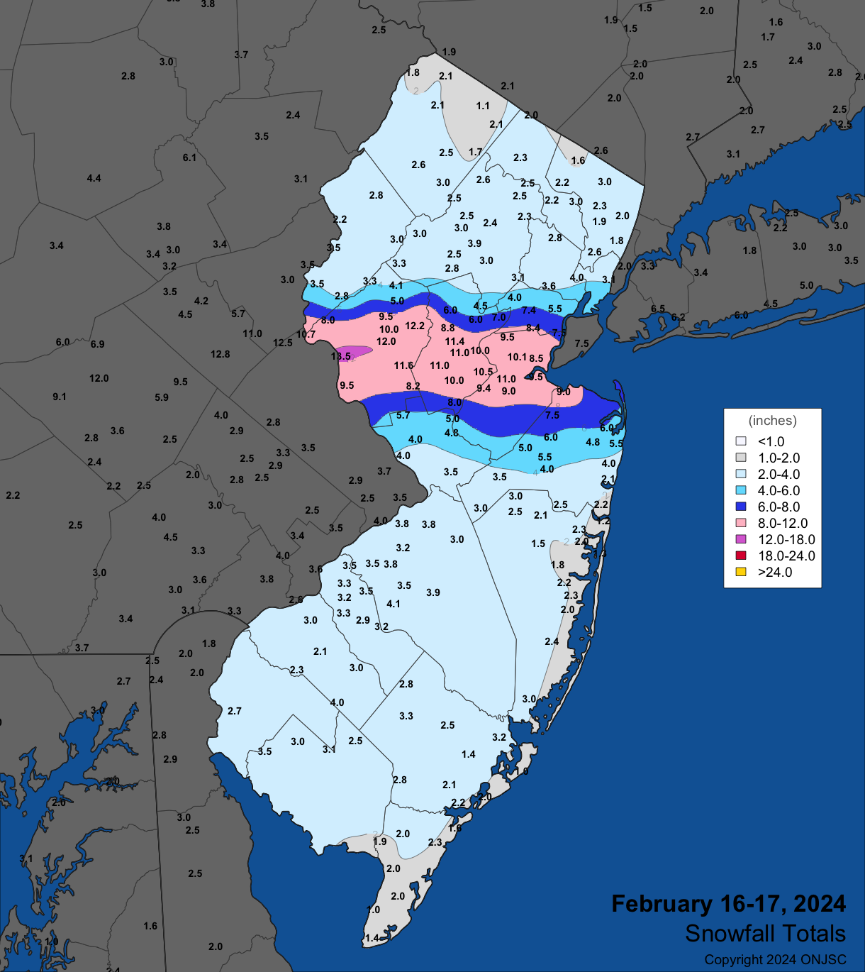
19 minutes ago, bluewave said:
Looks like this will end up as a 10-15.6” winter for most closer to the coast.
CT IGOR I SIKORSKY MEMORIAL AIRPORT WBAN 15.6 CT RIDGEFIELD 3.6 N CoCoRaHS 15.6 CT GUILFORD COOP 15.5 CT MIDDLEFIELD 1.4 W CoCoRaHS 15.5 CT DANBURY COOP 15.4 NY MOUNT SINAI COOP 15.3 NJ GLEN ROCK 0.7 SSE CoCoRaHS 15.2 NY HOWARD BEACH 0.4 NNW CoCoRaHS 15.2 NJ WAYNE TWP 0.8 SSW CoCoRaHS 14.9 CT NORWALK 2.9 NNW CoCoRaHS 14.7 CT NEW CANAAN 3.8 N CoCoRaHS 14.7 NJ NEW PROVIDENCE 0.8 ESE CoCoRaHS 14.7 NY RIDGE 1.5 SE CoCoRaHS 14.5 NJ CLARK TWP 1.3 ENE CoCoRaHS 14.3 NJ POMPTON LAKES 1.0 ENE CoCoRaHS 14.2 NY COMMACK 1.3 SW CoCoRaHS 14.1 NY PORT JEFFERSON STATION 0.3 SSW CoCoRaHS 13.9 CT NORWICH 5.4 SE CoCoRaHS 13.9 NY NESCONSET 1.4 SSW CoCoRaHS 13.7 NJ TENAFLY 1.3 W CoCoRaHS 13.6 NJ MONTCLAIR 0.7 N CoCoRaHS 13.5 CT HIGGANUM 0.8 NE CoCoRaHS 13.5 NJ HAWTHORNE 1.0 SSE CoCoRaHS 13.4 NY NEW HEMPSTEAD 0.6 SE CoCoRaHS 13.4 CT RIDGEFIELD 3.7 NNE CoCoRaHS 13.4 NY STATEN ISLAND 1.4 SE CoCoRaHS 13.4 NJ VERONA TWP 0.8 W CoCoRaHS 13.3 NJ FAIR LAWN 1.2 SE CoCoRaHS 13.2 NY BRIGHTWATERS 0.7 NNW CoCoRaHS 13.1 NY ST. JAMES COOP 13.0 NY JFK INTERNATIONAL AIRPORT WBAN 12.8 NY UPTON COOP - NWSFO NEW YORK COOP 12.7 NY MANHASSET HILLS 0.2 NNE CoCoRaHS 12.4 NJ HARRISON COOP 12.4 CT MYSTIC 3.4 NW CoCoRaHS 12.4 CT SEYMOUR 1.2 WSW CoCoRaHS 12.4 CT NORWICH 5.2 SE CoCoRaHS 12.3 NJ NEWARK LIBERTY INTL AP WBAN 12.2 CT KILLINGWORTH 2.6 ESE CoCoRaHS 12.2 NJ KEARNY 1.7 NNW CoCoRaHS 11.6 NJ MAPLEWOOD TWP 0.9 SE CoCoRaHS 11.2 CT NORWICH PUBLIC UTILITY PLANT COOP 11.1 NJ RIVER EDGE 0.4 NNE CoCoRaHS 11.0 CT ANSONIA 1 NE COOP 11.0 NY BELLMORE 0.9 SSE CoCoRaHS 10.9 NY ISLIP-LI MACARTHUR AP WBAN 10.9 CT STRATFORD 0.9 W CoCoRaHS 10.9 NY SYOSSET COOP 10.8 CT BETHEL 4.5 SSE CoCoRaHS 10.8 NY LITTLE NECK 0.3 SE CoCoRaHS 10.7 NY RIVERHEAD RESEARCH FARM COOP 10.7 NY LAGUARDIA AIRPORT WBAN 10.5 CT PAWCATUCK 1.8 SSE CoCoRaHS 10.3 NY WEST POINT COOP 10.2 NJ WEST CALDWELL TWP 1.3 NE CoCoRaHS 10.2 NJ WESTFIELD 0.8 WSW CoCoRaHS 10.2 CT WALLINGFORD CENTER 1.9 WNW CoCoRaHS 10.1 NY AMITYVILLE 0.6 NNE CoCoRaHS 10.0 NY REMSENBURG-SPEONK 0.9 NE CoCoRaHS 10.0 Probably the best we could have done knowing what we know now about how it played out
-
4
-
-
2 minutes ago, Brian5671 said:
who said anything about epic cold...my point is when you go back and look at our big March snow storms they are usually preceded by an arctic outbreak.
Don’t even go that far, just go back and read my post. I said nothing about arctic air or March snow. I’m not sure why you’re putting words in my mouth. You can be below avg in March without artic air and big snow
-
1
-
-
8 minutes ago, MANDA said:
Off topic for this thread but I'll post it here since the weather is quiet.
For those of you who were fans of Alan Kasper back in the day you will like this.
A friend of mine sent me this link so I am passing it along. Lots of great memories.
I worked weekends at WCBS late 1983 to late 85 and Alan had left by then. Wish I had gotten to meet him. A Legend.
What came after him not so much.
Here is link:
Kasper was so far ahead of his time. His updates on the mixing line and radar during a storm on the radio were a great source of information
-
2
-
-
2 minutes ago, Brian5671 said:
By then averages are 50-55 so you'd need some decent cold to get anything-and there's zero cold anywhere so good luck with that...
40-45 is still below avg. I’m not forecasting March 2018 to walk through the door. Why does everything have to surround epic cold/snow predictions with you?
-
1
-
-
I still think their is strong support for a cold spell in mid March but by that point who cares…
warmth starts next week for ext period
-
3
-
-
On 2/13/2024 at 11:31 AM, Stormlover74 said:
Feb 2006
Didn't want to clog up the storm thread or confuse people thinking this was a current radar
https://www.raymondcmartinjr.com/weather/2006/12-Feb-06.html
My first thundersnow experience
February 2024
in New York City Metro
Posted
Beautiful outside! Let’s keep this around