

Allsnow
-
Posts
23,585 -
Joined
-
Last visited
Content Type
Profiles
Blogs
Forums
American Weather
Media Demo
Store
Gallery
Posts posted by Allsnow
-
-
Crazy how wet we have been this winter but finished with such low snowfall
-
1 minute ago, Stormlover74 said:
All day long too
Ends early Friday morning
-
3 minutes ago, Allsnow said:
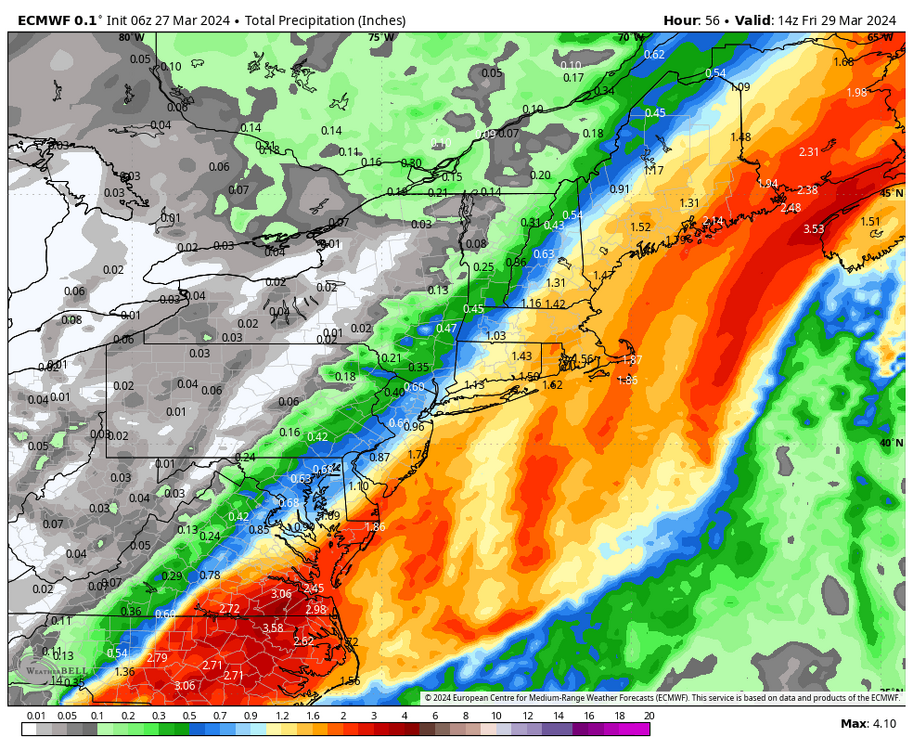
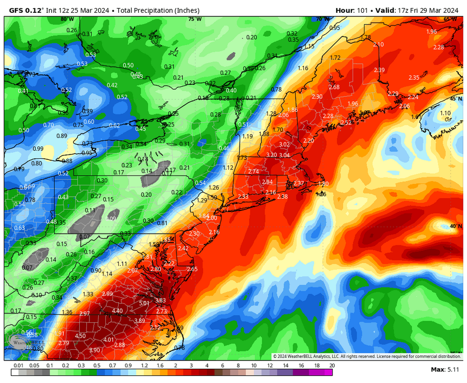
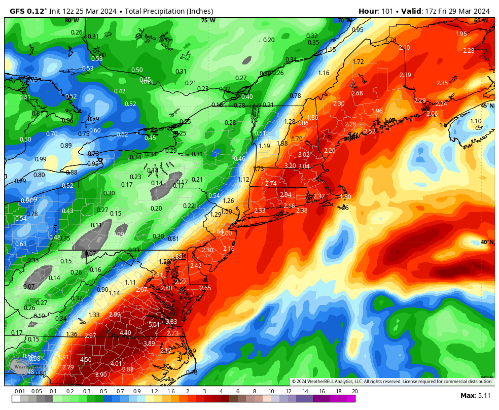
Nam is west with lots of rain for the area
2-3 wow
-
 1
1
-
-
Nam is west with lots of rain for the area
-
1
-
-
1 minute ago, forkyfork said:
i know it's the sref but it shifted way west and has an inch to pa
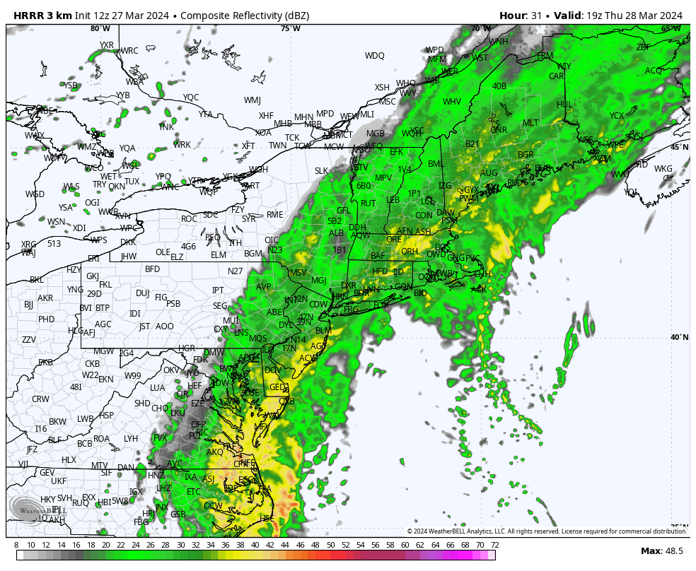
HRRR 3pm tomorrow

-
5 minutes ago, forkyfork said:
hrrr is coming west
Almost a inch by 9am tomorrow with more to Come
-
Euro with a big jump west
-
49 minutes ago, OrdIowPitMsp said:
Absolutely puking snow. Roads are completely covered. Building up that late March snowpack. This storm has been awesome. Finally kicked the doldrums of nothingness we’ve been in for months.
Yup, with temps crashing through the day it will freeze solid. Enjoy
-
 1
1
-
-
11 minutes ago, Brian5671 said:
Looks like a SE ridge there-maybe the blocking can link up and give us warmth...LOL
Yeah, ridge is flexing
-
1
-
-
4 minutes ago, bluewave said:
That 4 sigma 500 mb Greenland block in the forecast looks to be the strongest of the year so far. So a very active pattern will continue into early April. Spring will remain on hiatus for a while longer.

Brutal…
-
15 hours ago, OrdIowPitMsp said:
This season has reminded me how true this is for our region. I won’t give my final season grade until 4/15 at the earliest and this storm has likely bumped it up a half letter.
WWA hoisted for a couple more inches of snow with the deformation band as we fall back below freezing overnight into tomorrow morning. There will be a rock solid glacier by Wednesday, which looks downright frigid for late March.
Looks like the rain/snow line has collapsed through the city now. What a wild event for your area…
The qpf amount is impressive for the Midwest
-
1
-
-
28 minutes ago, ORH_wxman said:
Individual i took it as
This
-
Good amount of idv eps members that look like the gfs
-
1
-
-
16 minutes ago, The 4 Seasons said:
How the 12Z ECMWF is fully out to 240hrs on wxbell is beyond me, doesn't seem possible.
It’s also faster in finishing now. Next winter the 12z run will be completed by 1:15pm
-
@bluewave why do you think we keep getting a stronger passage in p8-1 outside DJF
-
1
-
-
3 minutes ago, 40/70 Benchmark said:
I wonder why the west PAC warm pool only prohibits entry into phase 8-1 during the cold season....perhaps as the relatively cooler ambient waters begin to warm (cool in the fall) it loses (gains) pervasiveness throught the Hemisphere?
Same pattern happened last March which gave interior New England a huge event.
It’s very frustrating that we can’t line a pattern up like this in DJF
-
1
-
 1
1
-
-
17 minutes ago, CoastalWx said:
Just looping the GFS...where the fook was this pattern all winter?!?!?!?!?
We couldn’t get a strong wave in p8-1 this winter. It’s finally happening along with a wave breaking-nao.
-
1
-
-
3 minutes ago, nycwinter said:
thank goodness i took my gloves my hands would have been frozen...
Yup, the March sun can be brutal
-
 1
1
-
-
9 minutes ago, Allsnow said:
Gfs will be well west this run
-
2
-
-
15 minutes ago, snowman19 said:
We will be in the bullseye come Wednesday
Gfs will be well west this run
-
1
-
-
6 minutes ago, Brian5671 said:
usual correction N and W will make this a hit
Yup. Ridge will correct stronger
-
2
-
-
20 hours ago, jm1220 said:
For the Valentines Day 2007 storm I lived in Central PA. That's exactly what it was-probably 8" of snow in 3" of sleet. 4" of snow then the sleet and 4" at the end that added up to 10-12" of absolute cement. Temps were in the teens to around 20 the whole storm. That seriously was the heaviest, densest concrete I remember falling out of the sky. It froze solid and lasted for weeks. In other parts of the state it was so disruptive that major roads/interstates shut down because it's so hard to move. I think in that storm much of this subforum had a big ice event. Much of upstate NY/NNE had 24"+ which I would've much rather experienced, but all the dense sleet made what I had probably just as disruptive. The St Patricks Day 2007 storm I was home on Long Island and remember the insane amount of sleet from that one. So that month long period I saw more sleet than any other time in my life.
Sounds like a great experience. It would be very enjoyable to get a storm like what you experienced in middle January. The pack would be bulletproof for weeks.
-
1 minute ago, Allsnow said:
Some good returns moving north might be cooling the column enough for huge flakes
-
2
-
-
1 minute ago, OrdIowPitMsp said:
There was a period of 1-2”/hr rates before the changeover but I was asleep.
It’s absolutely puking snow in White Bear Lake. From downtown on north it’s all snow right now and the roads are getting covered again. Silver dollar size flakes. Home and the airport are reporting a mix.
Some good returns moving north might be cooling the column enough for huge flakes


March 2024
in New York City Metro
Posted
Huge batch of rain sw of phl will be moving in late this afternoon