

Allsnow
-
Posts
26,403 -
Joined
-
Last visited
Content Type
Profiles
Blogs
Forums
American Weather
Media Demo
Store
Gallery
Posts posted by Allsnow
-
-
8 hours ago, SnoSki14 said:
It's not going to be dry.
Just like this weekend was supposed to be dry
-
 1
1
-
-
3 minutes ago, winterwarlock said:
still at 81 dew with 111 heat index
Warm muggies
-
1
-
-
Euro says congrats Great Lakes
-
 1
1
-
-
32 minutes ago, dave0176 said:
Not avoiding storms today lol
Lots of lightning in that storm
-

-
5
-
1
-
-
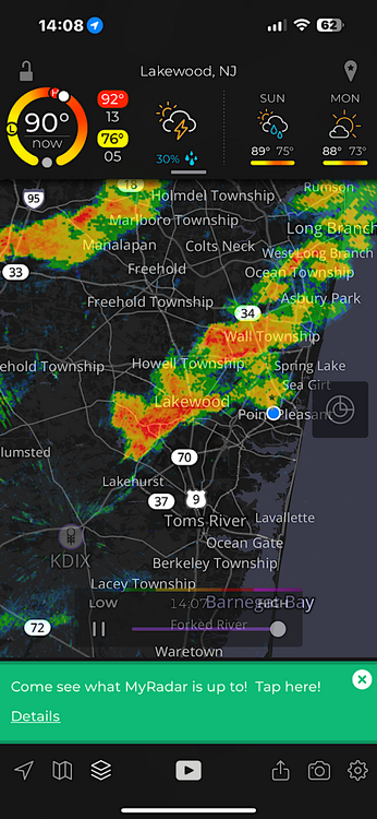
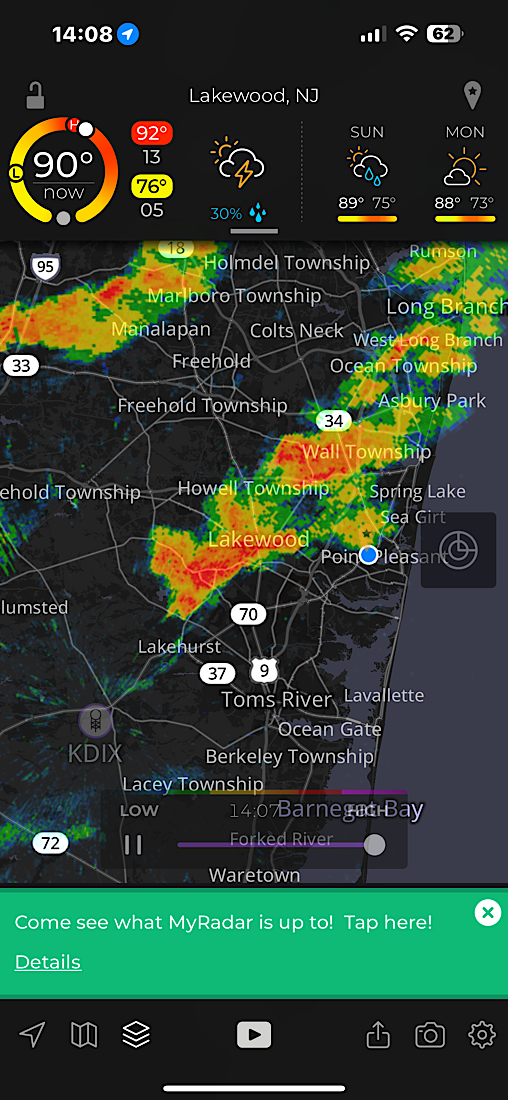
Good amount of CTG lighting strikes with these storms the past few days
-
4 minutes ago, winterwx21 said:
It looks like that downpour in Somerset is going to miss me just to the south but might hit you. It's going to be close.
Sorry. Looks like to coming directly for me now
-
2
-
-
HRRR hitting the same areas now for this evening as yesterday
-
2
-
-
9 minutes ago, winterwx21 said:
And I see the latest models do have a few pop ups for this afternoon. Probably will be a few areas that get lucky.
Yup, showers developing in western jersey. I wouldn’t bet on staying dry with this type of airmass
-
4
-
-
Soupy
-
15 minutes ago, Brian5671 said:
FWIW they have little to nothing rest of today....
We shall see, yesterday was supposed to have nothing either until we got closer
-
3 minutes ago, bluewave said:
Same here. Picked up .50 in 15 minutes. The atmosphere was saturated with 75° dew points and 2.00” PWATS. It’s one of the few times I had fog and light drizzle transition to such a heavy downpour in July.
Models doing a poor job forecasting the convection each day. Yesterday was supposed to be dry and this morning
-
1
-
-
43 minutes ago, Allsnow said:
#notawetpattern
.27 this morning
-
10 minutes ago, Snowlover11 said:
CT has been storm captial of the world lately. crazy.
#notawetpattern
-
Raining here again, so much for the dry weekend
-
Flooding in ct
#notawetpattern
-
-
Western Essex NJ- Eastern Bergen NJ-New York (Manhattan) NY-Kings (Brooklyn) NY-
...STRONG THUNDERSTORMS WILL IMPACT HUDSON...EASTERN UNION...SOUTH CENTRAL BERGEN...SOUTHEASTERN ESSEX...RICHMOND...KINGS AND NEW YORK (MANHATTAN) COUNTIES THROUGH 730 PM EDT...
At 705 PM EDT, Doppler radar was tracking strong thunderstorms along a line extending from Newark to near Tottenville. Movement was northeast at 25 mph.
HAZARD...Wind gusts up to 40 mph and pea size hail.
SOURCE...Radar indicated.
IMPACT...Gusty winds could knock down tree limbs and blow around unsecured objects. Minor hail damage to outdoor objects is possible.
Locations impacted include... Newark, Jersey City, Elizabeth, Bayonne, Hoboken, Linden, Orange, Lyndhurst, Rutherford, Secaucus, Harrison, Ridgefield, Todt Hill, Huguenot, and The Verrazano Narrows Bridge.
-
1 minute ago, bluewave said:
Yeah, close to the all-time highest dew points around your region today. The all-time highest temperatures missed to our south today. Glad you are getting better rainfall recently.
RECORD EVENT REPORT
NATIONAL WEATHER SERVICE RALEIGH NC
438 PM EDT FRI JUL 05 2024

...ALL TIME RECORD HIGH TEMPERATURE SET AT RALEIGH NC...

THE ALL TIME RECORD HIGH TEMPERATURE OF 106 DEGREES WAS SET AT
RALEIGH NC TODAY. THIS BREAKS THE PREVIOUS ALL TIME RECORD HIGH OF
105 WHICH WAS SET MOST RECENTLY IN 2012.

TODAY'S OLD RECORD OF 102 DEGREES WAS SET IN 1999.
Thank you @bluewave
Just the start of this wet pattern, great call by you
-
1
-
-
24 minutes ago, Stormlover74 said:
Looks like it blew up just to your east
.50 here in like 20 minutes haha
Over a inch in 24 hours
-
4
-
-
About to get hit again here today
-
1 hour ago, bluewave said:
The Euro is similar to the SPC HREF next few days. Mid to upper 70s dew points and the potential for locally heavy downpours. Looks like the sea breeze boundaries and pre frontal trough will be the focus for convection and high dew point pooling.


Yup, tomorrow looks the wettest for the area
-
1
-
-
8 minutes ago, winterwx21 said:
That model has become a disaster. Sad because HRRR is supposed to be a highly skilled short range model that we can count on. Hopefully it can be replaced with something better eventually.
At least the different model runs that showed some pop ups during the afternoon were wrong. That's one thing HRRR got right at least. It was completely quiet for all of NJ until that little downpour that hit your area popped up a little before 8pm. It went very well for cookouts, but unfortunately not looking good for fireworks tonight. Sucks because we had absolutely perfect weather the last 3 days. Terrible timing.
Agreed. Edison moving their fireworks up to 845 to miss the rain now
-
1
-
-
4 minutes ago, Allsnow said:
Yup. HRRR fail
.22 so far today


July 2024
in New York City Metro
Posted
Beats 40 and rain during the winter months