

Allsnow
-
Posts
26,403 -
Joined
-
Last visited
Content Type
Profiles
Blogs
Forums
American Weather
Media Demo
Store
Gallery
Posts posted by Allsnow
-
-
1 minute ago, Stormlover74 said:
Looks good for areas along and north of 78
Miss potential for our small area is going up
-
1 minute ago, forkyfork said:
yes. my dewpoint is 80 lol
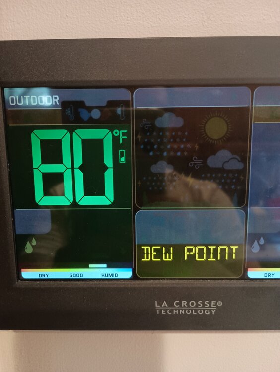
Crazy. I always find these high humidity day more interesting then what we had last weekend
-
Northeast metro and northern Manhattan probably get hit with that NNJ storm. It’s dropping south fast
-
Just now, forkyfork said:
looks like the line sags through the metro and fills in to me
Similar to what happened in Ct?
-
Rain train for CT shore wow
-
1 minute ago, FPizz said:
Warning just issued
Don’t see the south trajectory of that storm currently
-
 2
2
-
-
Just now, Stormlover74 said:
That line isn't making it here unless it builds further south
Yup. See no evidence of that
-
3 minutes ago, Stormlover74 said:

Our area might get missed
-
1 minute ago, Stormlover74 said:
Sun is out now
Yup
-
Wow!
Areas affected...northern NJ into western Long Island/NYC Metro vicinity
Concerning...Severe Thunderstorm Watch 489...
Valid 301826Z - 302000Z
The severe weather threat for Severe Thunderstorm Watch 489 continues.
SUMMARY...An intense bowing segment will move across northern New Jersey into western Long Island and the New York City metro vicinity over the next 1-2 hours. Damaging wind gusts are expected with these storms.
DISCUSSION...A cluster of storms has rapidly intensified and developed into a bowing segment near the northern NJ/PA state line this afternoon. This activity will spread east/southeast over the next 1-2 hours into the axis of strong instability oriented over the northern Mid-Atlantic region. These storms have already produced gusts to near 50 kt and areas of wind damage. This activity is likely to continue producing severe/damaging wind gusts as storms spread across northern NJ and the New York City metro vicinity.
-
2
-
-
NWS Upton still all in for this afternoon severe threat
-
1 minute ago, winterwx21 said:
Yeah we won't completely clear out, but at least we'll have breaks.
Some cells starting to pop up further to the south in PA. We should have a decent shot at seeing something later today, but obviously it's far from a guarantee.
Parts of extreme snj got 8-10 inches of rain this morning. Crazy
-
1
-
-
3 minutes ago, SACRUS said:
85 / 75 some breaks in the clouds, storms firing north NJ - HVlley , CT.
Yikes. Might not clear out in time
-
Areas affected...southern New England, southern New York State, eastern Pennsylvania, northern New Jersey
Concerning...Heavy rainfall...Flash flooding possible
Valid 301744Z - 302344Z
Summary...Bands of scattered thunderstorm activity were moving quickly to the east, but also merging/training locally to produce spots of 1+ inch/hr rain rates at times. These rates could cause flash flood potential to increase through the early evening.
Discussion...Storms have deepened and expanded in coverage within a strongly unstable airmass across the discussion area over the past hour. The storms are aligned along and just ahead of a surface cold front across central PA/southern New York and were embedded in deep westerly flow, promoting 30-40 kt storm motions. Of particular concern, however, is the alignment of convection across Connecticut and southern New York favoring training, which has boosted rain rates into the 1-1.5 inch/hr range, threatening local FFG thresholds.
Models/observations are in general agreement that storms will continue to train/expand eastward while propagating southward/eastward toward more populated locales (including New York/northern New Jersey, Providence RI, and Boston). Not only are FFGs locally lower in some of these areas, but urban/hydrophobic surface may promote a local flash flood risk especially where rain rates exceed 1 inch/hr. Flash flooding is possible given the aforementioned scenario.
-
3 minutes ago, Stormlover74 said:
CT is finishing one hell of a severe weather month
Crazy two week stretch for them. We have mainly missed out down here
-
1 minute ago, forkyfork said:
it's completely wrong to our north so it doesn't mean anything

Good catch. It completely missed the storm in SNE a few days ago that caused widespread damage
-
Latest HRRR hammers snj
-
1
-
-
CT getting crushed again
-
22 minutes ago, winterwx21 said:
It does feel strange to have such a big severe weather threat on day that's completely overcast. Hopefully it won't hurt chances for our area.
Yeah, that normally means a bust. We shall see…
-
4 hours ago, winterwarlock said:
About a 1/4 inch yesterday and overnight..meh
What time today for the rains. Im headed down the shore for a few hours and want to leave before it hits
Bad day for the beach
-
1 minute ago, JonClaw said:
URGENT - IMMEDIATE BROADCAST REQUESTED
   Severe Thunderstorm Watch Number 489
   NWS Storm Prediction Center Norman OK
   1110 AM EDT Sun Jun 30 2024

   The NWS Storm Prediction Center has issued a

   * Severe Thunderstorm Watch for portions of
     Connecticut
     Northern Delaware
     Massachusetts
     New Jersey
     Southern New York
     Central and Eastern Pennsylvania
     Rhode Island
     Coastal Waters

   * Effective this Sunday morning and evening from 1110 AM until
     700 PM EDT.

   * Primary threats include...
     Widespread damaging winds likely with isolated significant gusts
       to 75 mph possible
     Isolated large hail events to 1.5 inches in diameter possible

   SUMMARY...A mix of thunderstorm clusters and supercells should pose
   a threat for numerous to widespread severe/damaging winds as they
   move eastward this afternoon and evening. Peak wind gusts should
   generally range around 60-70 mph, with isolated gusts perhaps
   reaching up to 75 mph. Occasional hail around 1-1.5 inches in
   diameter may also occur with any sustained supercell.

   The severe thunderstorm watch area is approximately along and 100
   statute miles east and west of a line from 35 miles north northwest
   of Worcester MA to 30 miles west southwest of Philadelphia PA. For a
   complete depiction of the watch see the associated watch outline
   update (WOUS64 KWNS WOU9).

   PRECAUTIONARY/PREPAREDNESS ACTIONS...

   REMEMBER...A Severe Thunderstorm Watch means conditions are
   favorable for severe thunderstorms in and close to the watch area.
   Persons in these areas should be on the lookout for threatening
   weather conditions and listen for later statements and possible
   warnings. Severe thunderstorms can and occasionally do produce
   tornadoes.

   &&

   AVIATION...A few severe thunderstorms with hail surface and aloft to
   1.5 inches. Extreme turbulence and surface wind gusts to 65 knots. A
   few cumulonimbi with maximum tops to 500. Mean storm motion vector
   27035.

   ...Gleason
-
1
-
-
Mesoscale Discussion 1487
NWS Storm Prediction Center Norman OK
0855 AM CDT Sun Jun 30 2024Areas affected...portions of the Mid-Atlantic and southern New England
Concerning...Severe potential...Severe Thunderstorm Watch likely
Valid 301355Z - 301600Z
Probability of Watch Issuance...80 percent
SUMMARY...Thunderstorm coverage will gradually increase in coverage/intensity through midday. Swaths of damaging wind gusts are expected through afternoon. One or more severe thunderstorm watches will likely be needed in the next couple of hours for portions of the Mid-Atlantic into New England.
DISCUSSION...A very moist airmass is already in place across the region this morning, with surface dewpoints in the low to mid 70s F noted in observations. Temperatures are already in the upper 70s to low 80s, and even modest heating through broken clouds will aid in further destabilization toward midday. 12z RAOBs from ALB and OKX also indicate a strongly sheared environment, with effective shear magnitudes greater than 40 kt present. Early convection is already noted near Binghamton NY along an outflow boundary. Additional convection is developing further west across central PA ahead of an east/southeast-advancing cold front.
As convection gradually increases over the next few hours, bowing segments/clusters are expected given mostly unidirectional deep-layer flow. Large instability, high PW values, and steepening low-level lapse rates amid favorable shear will support swaths of damaging winds across the region through the afternoon into early evening. One or more watches will likely be needed for the region within the next couple of hours.
-
-
24 minutes ago, Stormlover74 said:
Hrrr is meh for many but really blasts the HV and CT
I hope the south jersey convection isn’t killing the afternoon potential for us


June 2024
in New York City Metro
Posted
Yeah, idk if we get much more then that…
hopefully it fills in but idk