wdrag
-
Posts
5,603 -
Joined
-
Last visited
Content Type
Profiles
Blogs
Forums
American Weather
Media Demo
Store
Gallery
Everything posted by wdrag
-
No thread until 230PM: PRE seems in play but best axis for 2-4" rain, isolated 5" is unknown though may be favoring LI or NJ. Just too soon. It's banded so some folks only 1/4" and others rejoice in 2+. 12z/19 guidance may be helpful. Timing of wetting event (positive impact imo for many in recent drought) is Noon Wed-Noon Thu. While impacts positive for needed rain, I think there will be fairly high negative impact Wed even-Thu AM commutes in and out of NYC. Second part of a potential thread is the unknown, whether TS gusts will reach s LI and Nj coasts (gusts 40-50 MPH) later Thu. Possibility of moderate coastal flooding, mainly NJ coast Thu eve. Rip currents and high surf are a given.
-
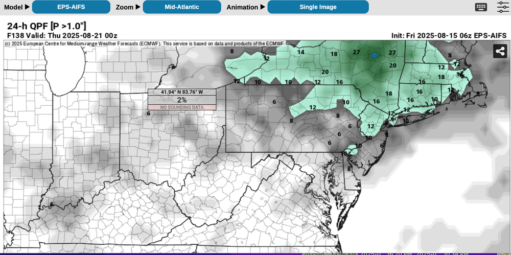
May issue a thread tomorrow morning for general 1/2-2" drought relieving rain event 10Z Wed-10z Thu, isolated 5". Too early, especially since 18z WPC less than 0.1" this week NYC subforum as too the 13z BOM. Meanwhile 12z EPS/EPS AI increasing since 00z cycles. 12z NAM had the idea of iso 3+. Again way too early for me but either physics is out to lunch or something else is wrong with my thinking. PRE conceptual sampler added. Just shift the modeling a bit too the east. Everything now within the 42-84 time hr frame.
-
fwiw... for those who need rain: 12z/18 NAM suite in particular has iso 3-6" near ABE and spotty SNE just outside our forum. 12z/18 Canadian and GFS coming up. No thread but monitoring. I think the NAM is telling us something that could happen around here but far too early, in light of model spread, to start a thread. Right now, I'll monitor WPC to see if start adding a little qpf to our NYC subforum. Yesterdays 2-5" vicinity Philly was not well handled by the SPC HREF.
-
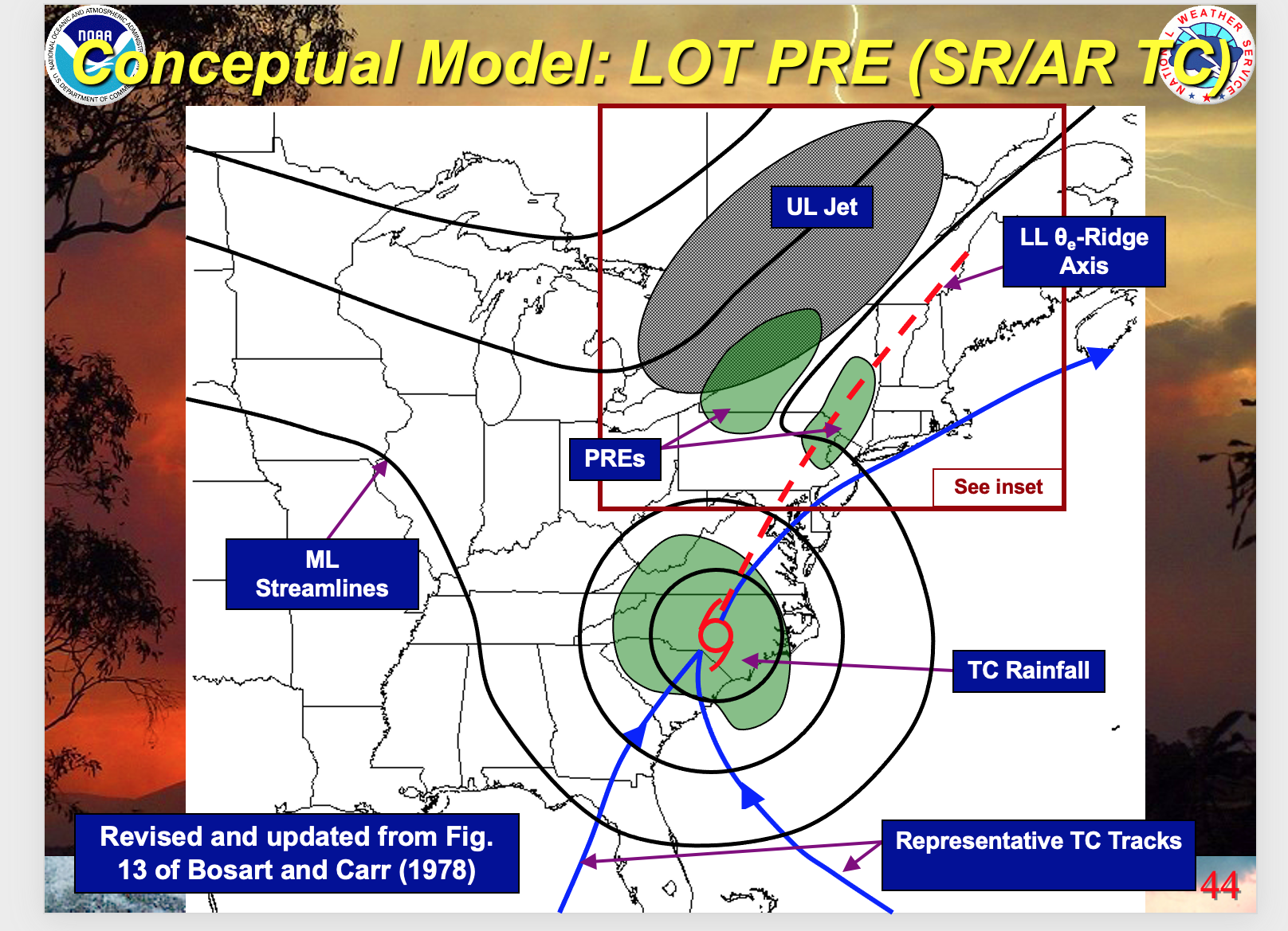
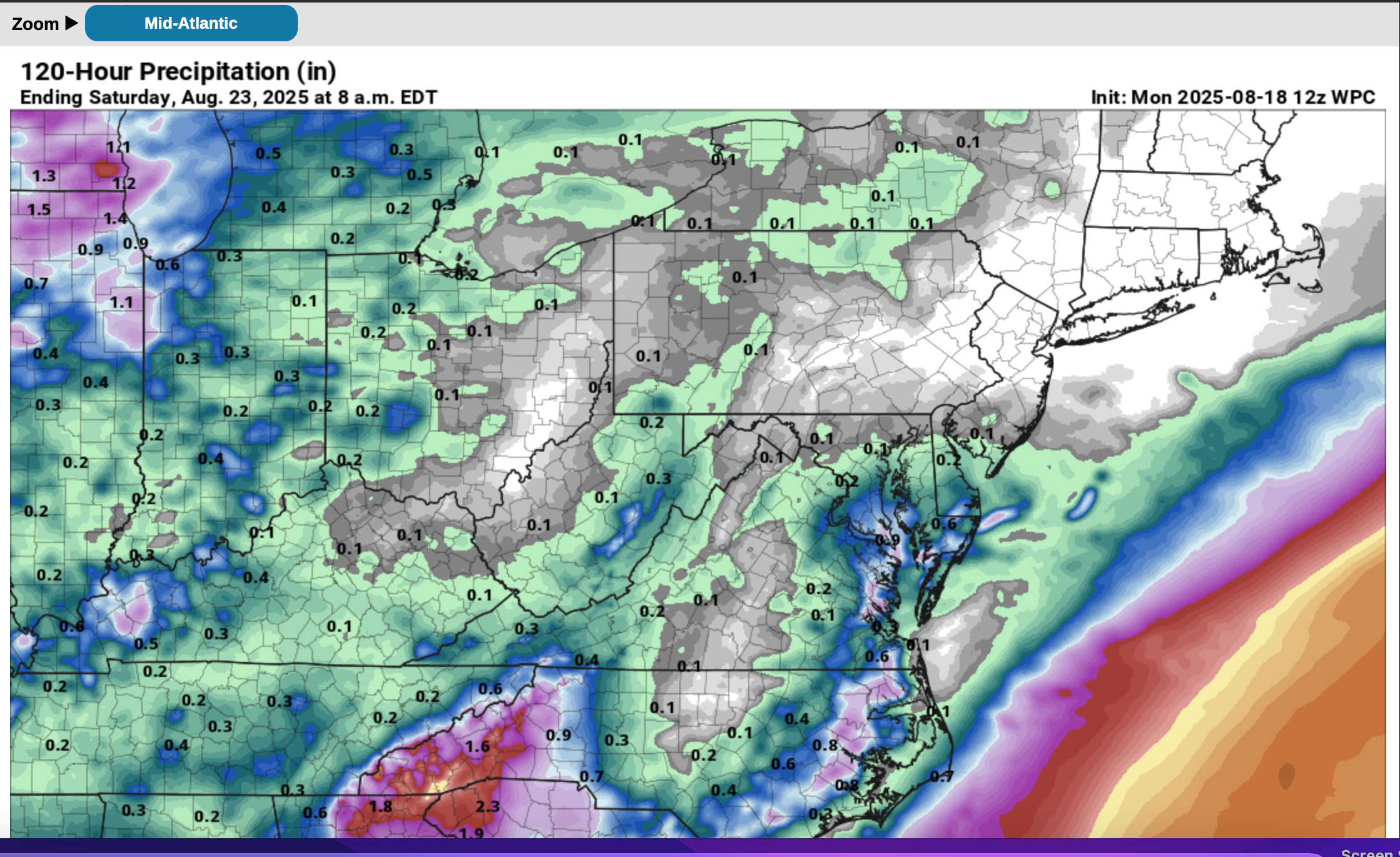
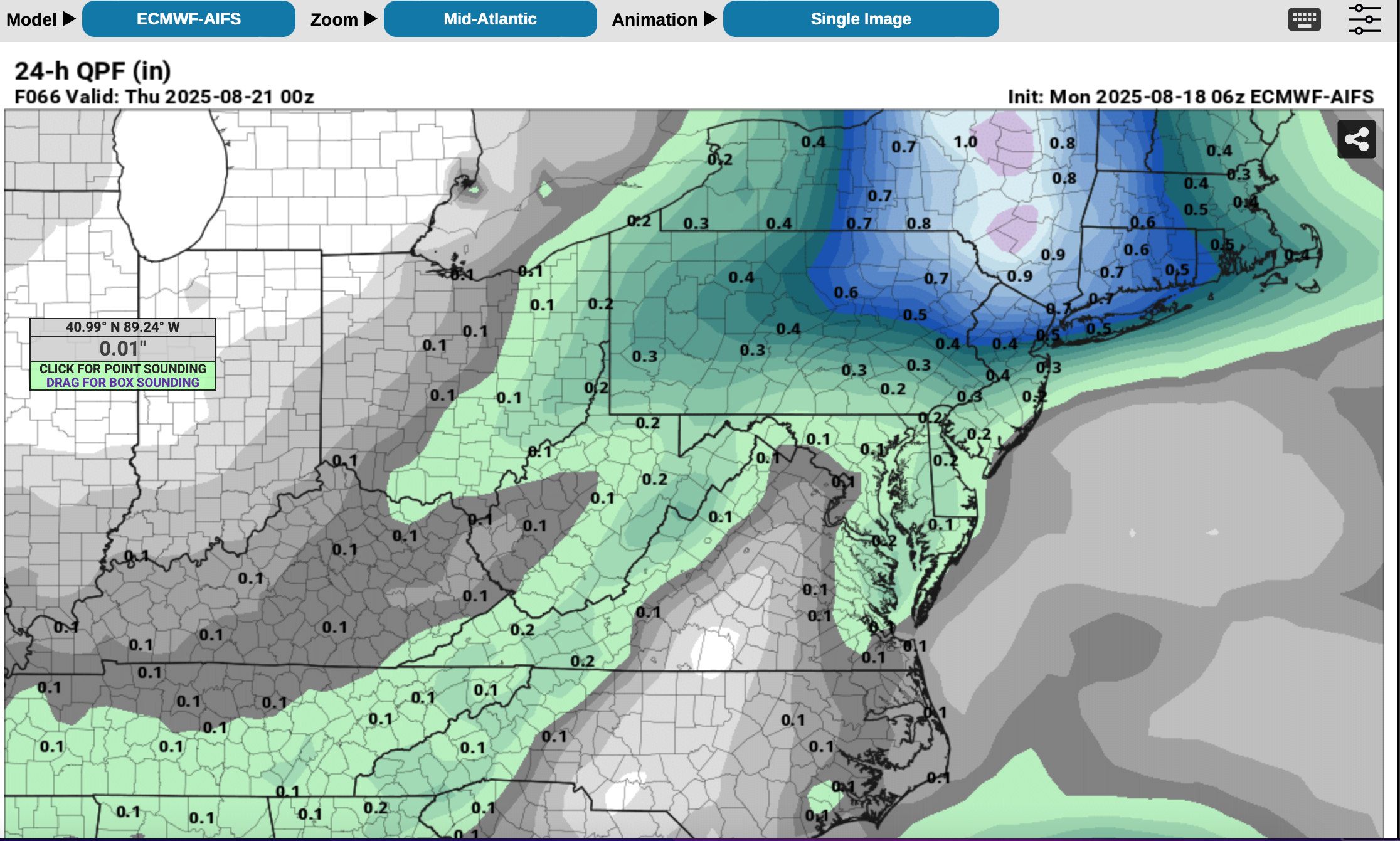
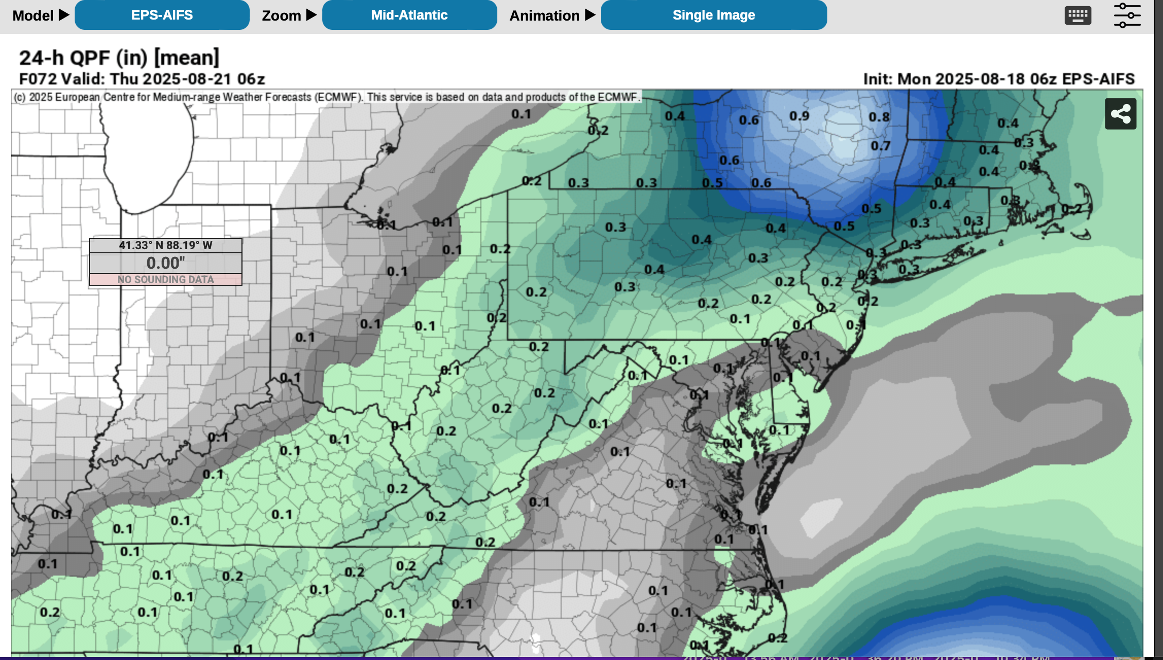
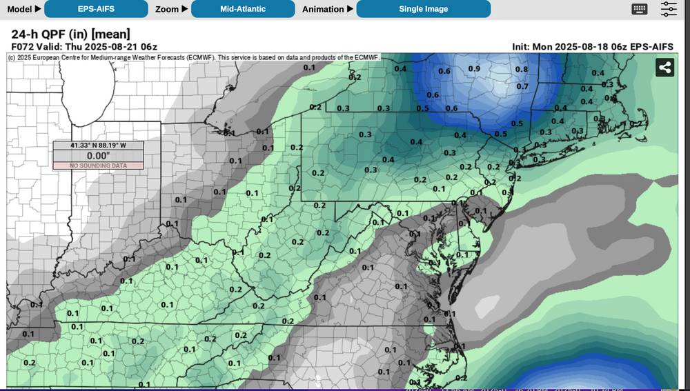
Testing modeling: WPC seems strongly attached to the much drier GEFS/EPS per no qpf in our subform, this week as per attached 5 day qpf issued around Mon 8/18 10z. Please follow NWS/WPC/NHC. I'll continue to monitor for my own interest on whether the more benign GEFS prevails over the more vigorous EPS in our NYC subforum. This post continues from Saturday 410PM and prior posts last week and will be a lesson for me regarding EPS and EPS AI. IF the GEFS is to prevail, EPS and EPS AI will have to dry out soon. EPS suite is as yet the most intriguing for 1-2" 12 hour general rainfall sometime between 8/19-21 for NJ/CT/NYS/PA, in part due to nw flow UL short wave with associated RRQ UL jet in the Maritimes and some relatively shallow low level ese moisture inflow related to the position of the H near Nova Scotia and the L near Lake Erie, connecting a bit with ERIN? EPS PW steady since the past Saturday near 1.5" for 12z Wed at 40N. Lots of fairly deep vorticity NYS into the mid Atlantic states along the boundary this week into Thu AM. Atlantic Recurvature PRE composite has had my attention since late last week. ODDS for recent drought easing rainfall per multi modeling are very low. Yet, continues my attention on ultimate results for Tue-Wed-Thu AM this week. Just to see how erroneous the EC AI can be. Added WPC 5 day, the 06z ECAI and its 06z ensemble as well as the 00z/18 EPS AI 24 hour prob for 1" (very low prob except I90 in NYS). EC EPS is less vigorous than the EC AI suite.


-
Follow NWS/WPC/NHC. I'll monitor for my own interest on whether the more benign GEFS prevails over the more vigorous EPS in our NYC subforum. 12z/16 EPS nw of envelope of remaining global solutions for ERIN. Glad I'm not fishing Atlantic waters Monday-Friday. EPS is as yet the most intriguing for 1-2" 12 hour general rainfall sometime between 8/19-21 for NJ/CT/NYS/PA, in part due to nw flow UL short wave with associated RRQ UL jet in the Maritimes and some relatively shallow low level ese moisture inflow related to the position of the H near Nova Scotia and the L near Lake Erie, connecting a bit with ERIN? EPS PW near 1.5 and increased over the past 24 hrs of EPS cycles for 12z Wed. Lots of fairly deep vorticity NYS into the mid Atlantic states along the boundary next week into Thu AM. 12z/16 EPS gusts much more significant our Atlantic waters vs more seaward GEFS and CMCE. Continues my attention on ultimate results for Tue-Wed-Thu AM next week. WPC at 1841z has added marginal risk for excessive D4 and 5. This line added at 2013z.
-
fwiw, am monitoring the middle of next week (8/19-21). Interacting northern stream short wave in the northeast USA with the ever so slightly imo (as of 06z/14 ensembles) westward drift track of Erin, low level moisture and RRQ of the UL jet near the Maritimes. Too early to be sure if its a player in a significant 12 hr rain event NYS/PA or the NYC subforum. Uncertainty is large 7-8 days in advance but some modeling has my attention, especially in parts of this area which have drying out in August. Will probably dismiss interest in a couple of days once the modeling says no-go.
-
Bluewave post from 5-6 days in the morning on EPS pattern and beautiful weather was right. EPS again, I'm afraid. Erin or Fernand looks next up... from the guidance I see a recurve but maybe close enough to help reduce our Aug rainfall deficit.
-
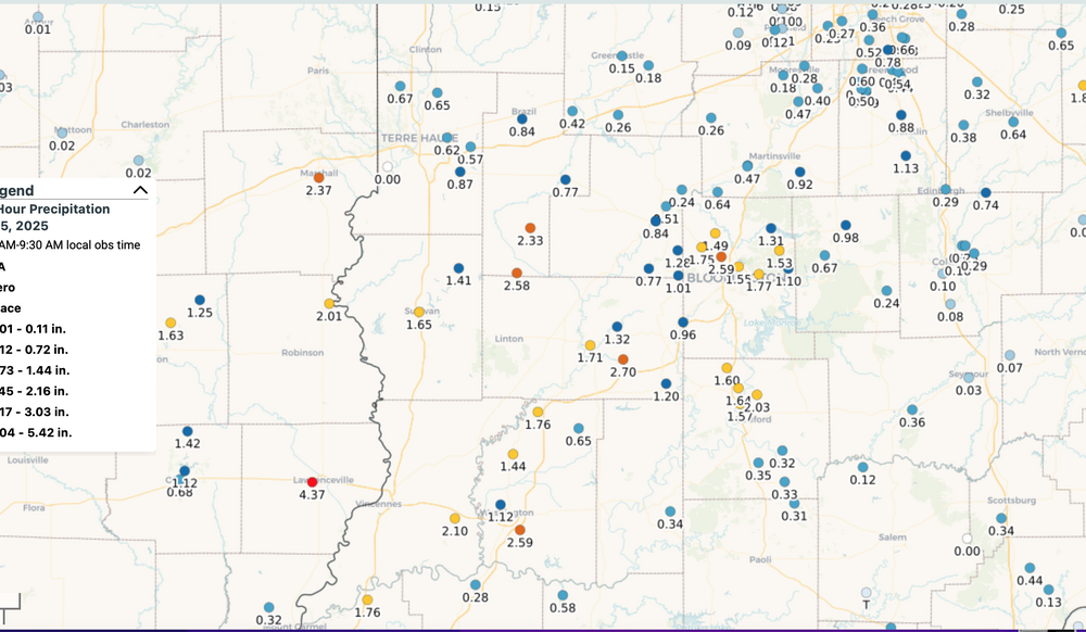
Modeling issues: Sort of a bust for our no rain last night... ONLY the EPS got it right 24 hours in advance (00z/6 cycle). In the longer range it looked bigger up through NJ/PA (my post on OH Valley low aloft) but GEFS was dry and so many forecasters opted for 20% or less chance yesterday, instead placing the 20% for today. Then as we drew closer to yesterday, all the modeling tended to shrink southward and I gave in to the dry GEFS (my mistake), but alas the EPS still held onto a little, which is what we got up through about 40-41N latitude. See attached graphic. Ohio Valley had isolated 4-5" in w Central Indiana/e Central IL, with some 2"s just e of Cincinnati on the 4th-5th respectively. Then last night we got our minor amounts, mostly evening on previously dismissed chances. I would say pretty deficient modeling for the northern fringe of the ne moving rain areas. CoCoRaHs attached for yesterday here and IN/IL for the 4th.
-
Showers developing?
-
Sea breeze boundary w LI. Showers now at 250 pm
-
I was wrong relying on EPS for the OH Valley potential rainfall here. GEFS looks far superior for late this week, well in advance. My wrong. Now I worry about flash drought here in the Tri state, especially if we dont get late day convection. Wind ix not large but long days, high evapotranspiration and no rain are a concern imo, for. drought ion we cant get some decent rainfall in the next week or two.
-
LOTS of easterly flow in that EPS image... moisture.
-
July 2025 Discussion-OBS - seasonable summer variability
wdrag replied to wdrag's topic in New York City Metro
Verification comments added to the initial post for July... actually imo, decently outlooked. -
00z/3 GEFS and consequently WPC looks misleading dry and underplayed middle and end of this coming week... PA/NJ/NYS. Developing Ohio Valley upper low spells trouble this first week of August... before a major warming occurs 2nd and 3rd weeks of August-back to H&H then. So, I'll have to self criticize if the 00z/3 DRY WPC 7 day in PA/NNJ/NYS verifies-accountability for words Expressed. The rain may no exceed 1/4''' but I think something is coming to NJ/e PA/s NYS. Exactly how and when is my greater uncertainty. Difficult to get 7-8 consecutive days of no measurable. Can happen--- Adding verification to July in a couple minutes.
-
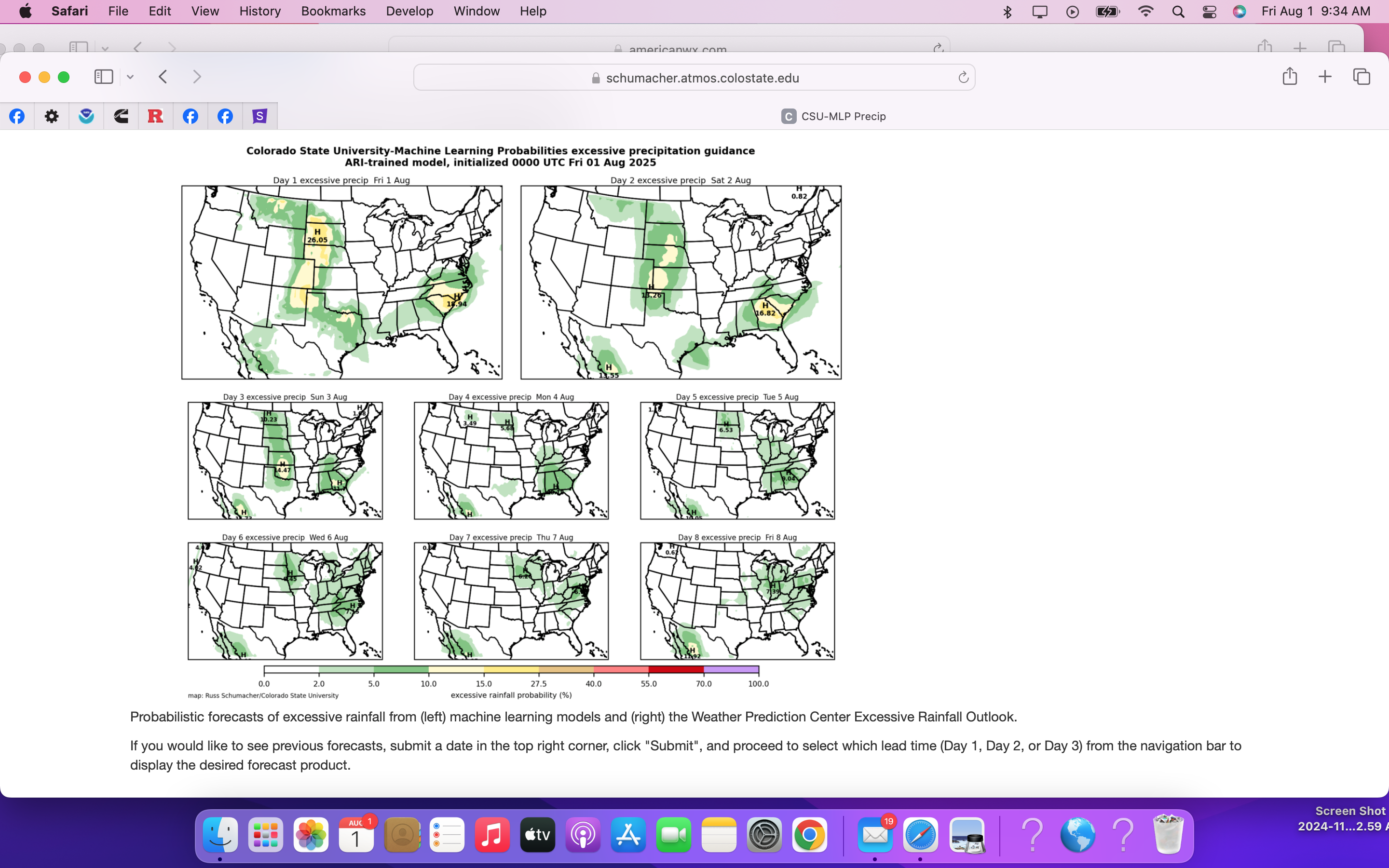
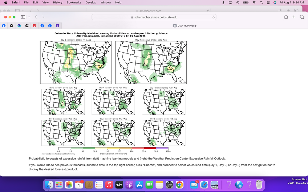
I am interested in the middle of next week. Ensembles say pay attention to what is going on in the Ohio Valley. Outlooking low prob flood potential here in our area later next week. See graphic.
-
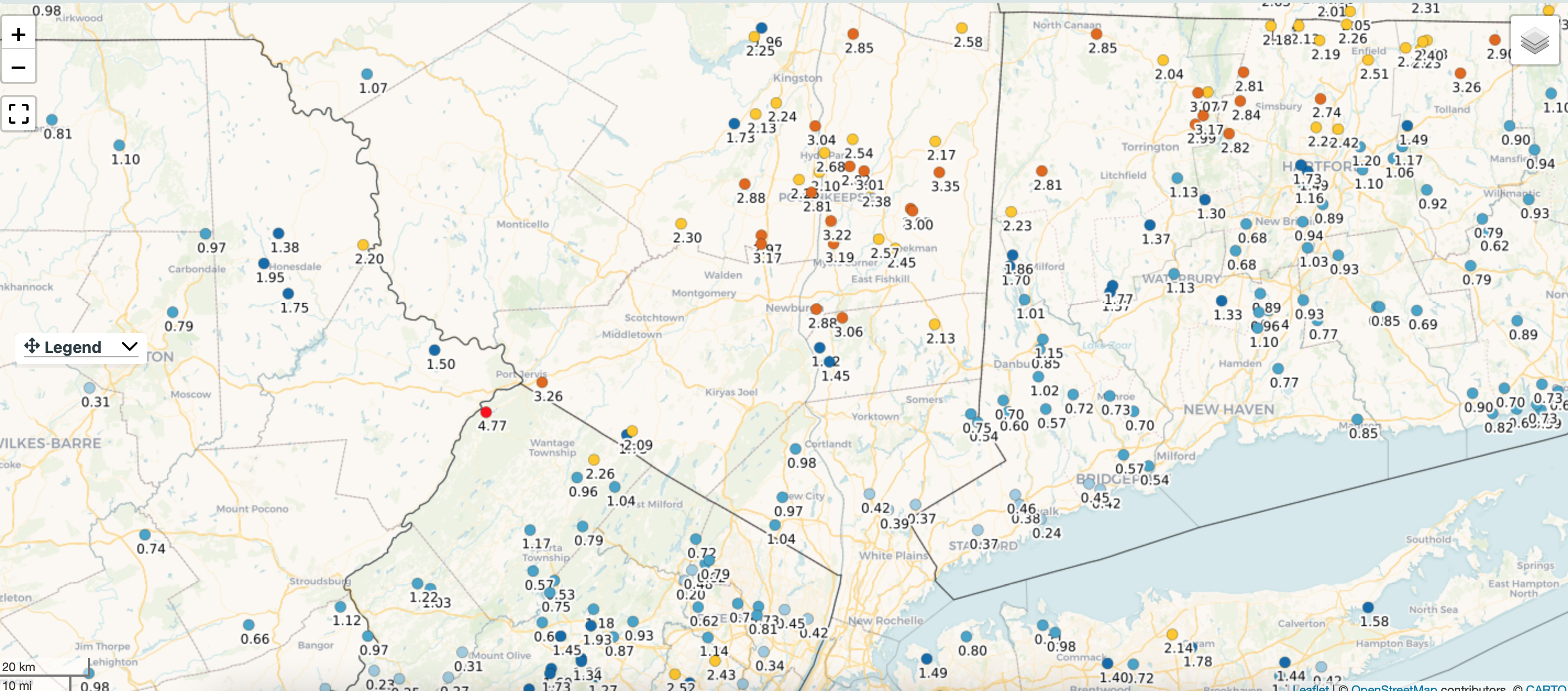
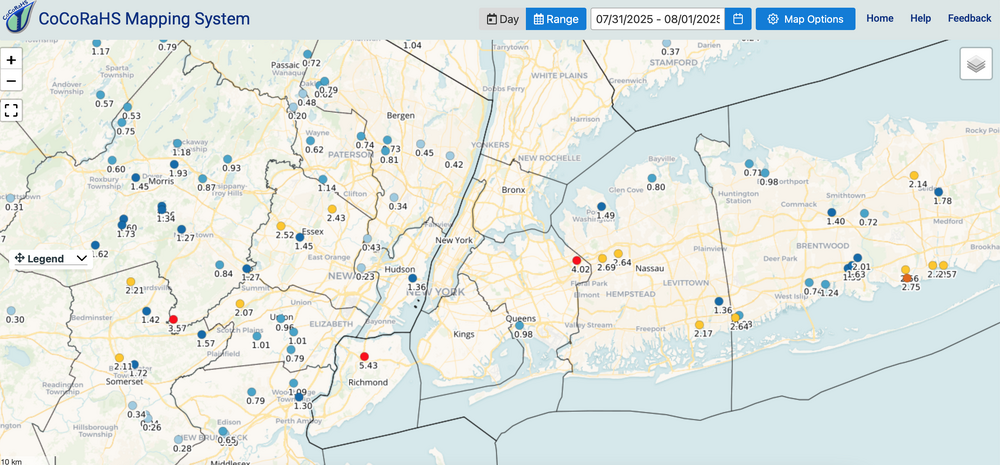
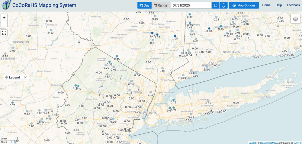
CoCoRaHs reports... you see the 4"s and 5"s as a sampler. When you compare the max rainfly axis... I think the EPS had the best idea from the start and all ensembles had the max GENERAL 2-3" rainfall northwest edge of our NYC forum. HOWEVER: the value of the MAX potential SPC HREF rainfall posted on p1, was possible in our area. I've not seen max rainfalls but suspect iso 6". Therefore the thread had added value using the SPC HREF MAX rainfall...its never perfect but having the max occur in the center of the NYC subforum is no surprise... at least we were bordered N and S edges by the modeling and knowing it's imperfect permits leeway considerations. I always keep in mind lack of modeling perfection and leave options open. Click graphics for clarity. I chopped off the time covered but trust it's 7/30-31.
-
will post a CoCoRaHs 2 day total at 9A and add some positive comment about the ensembles (global, mesoscale),
-
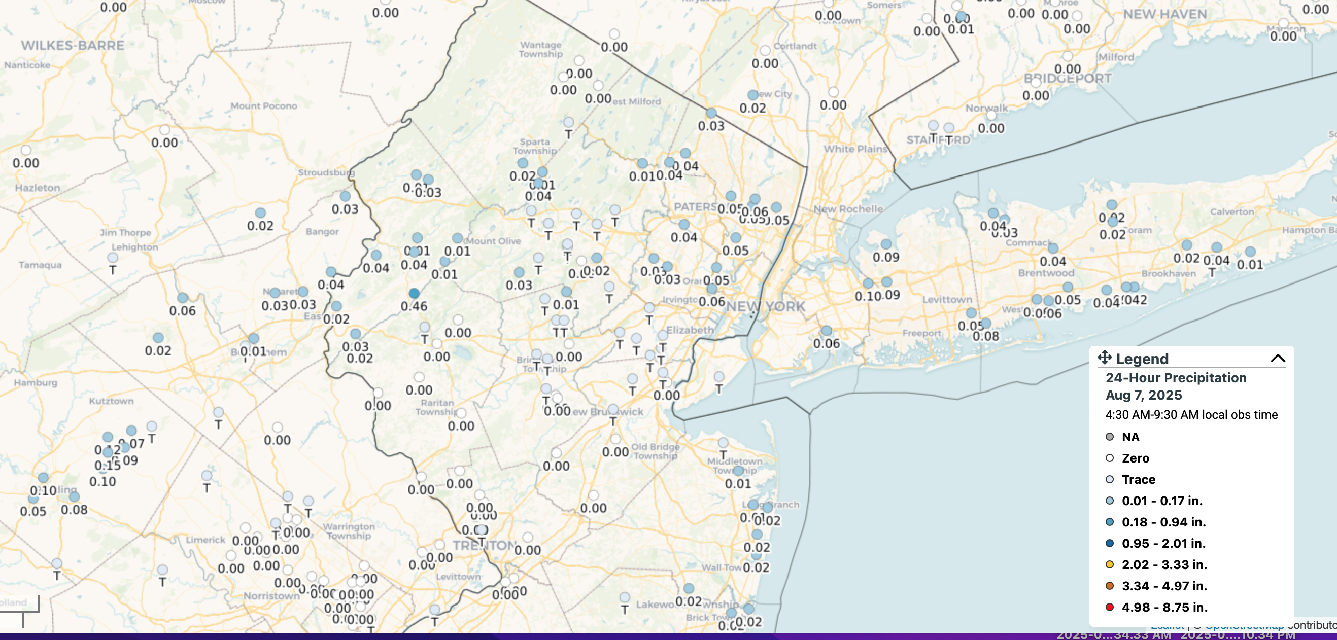
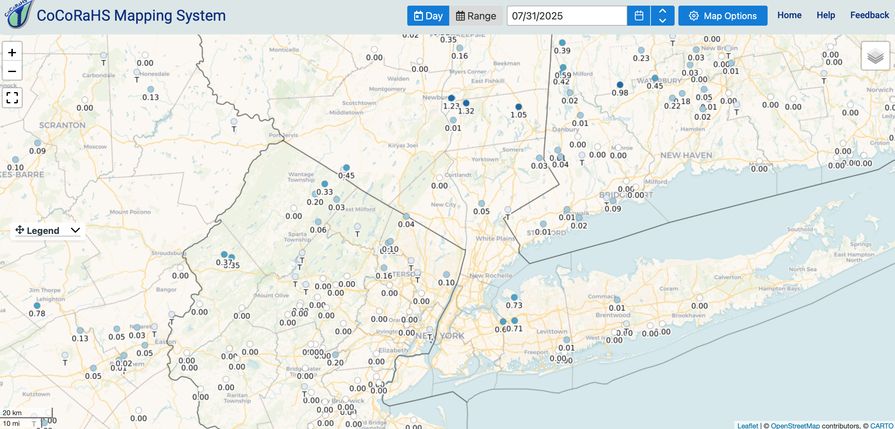
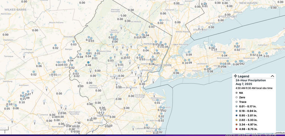
This is accurate. for the locations posted---climate sites. Zooming in gets a few more stations but its only rolling 24 hour rainfall, deepening on the you select the map.
-
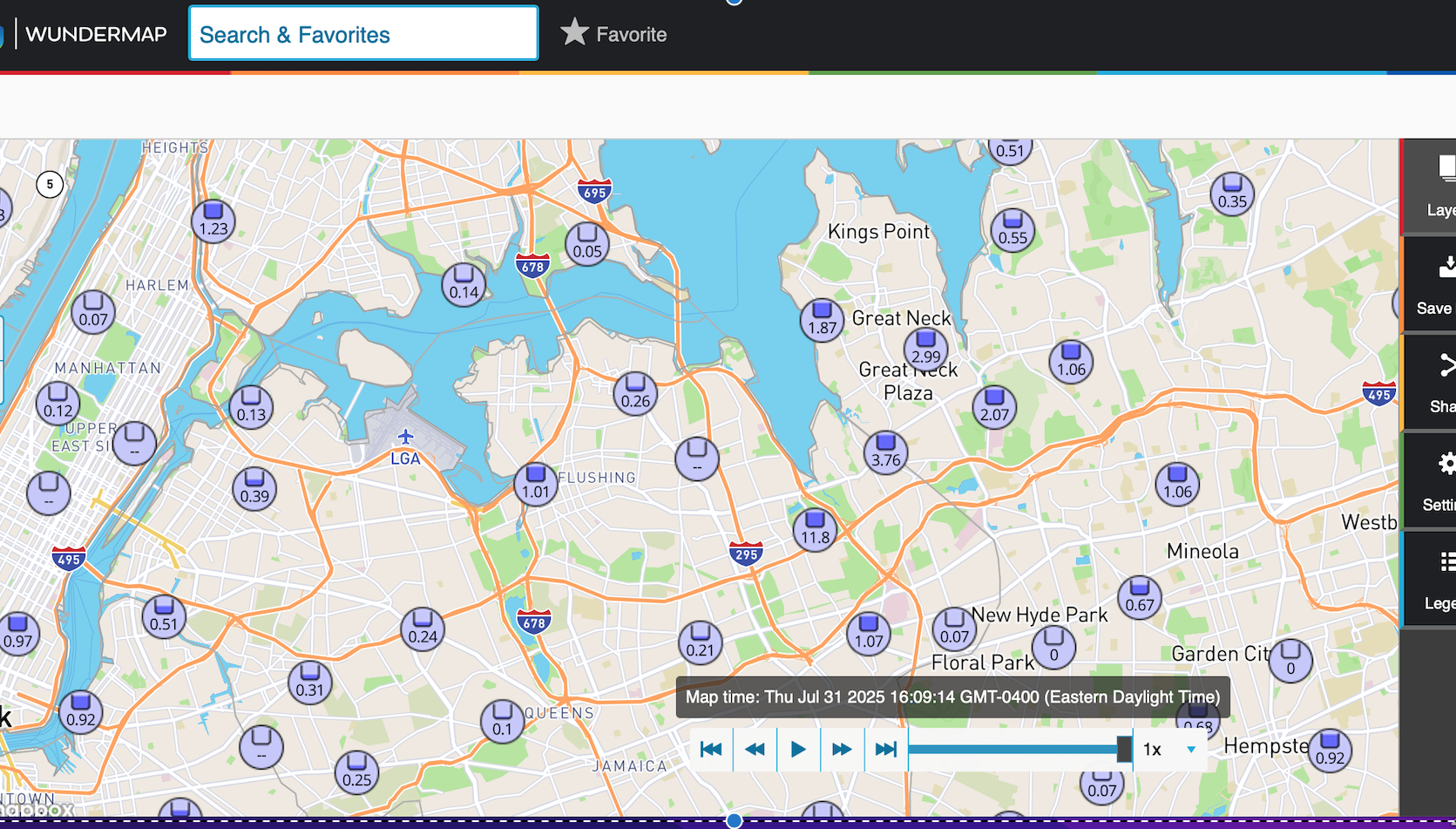
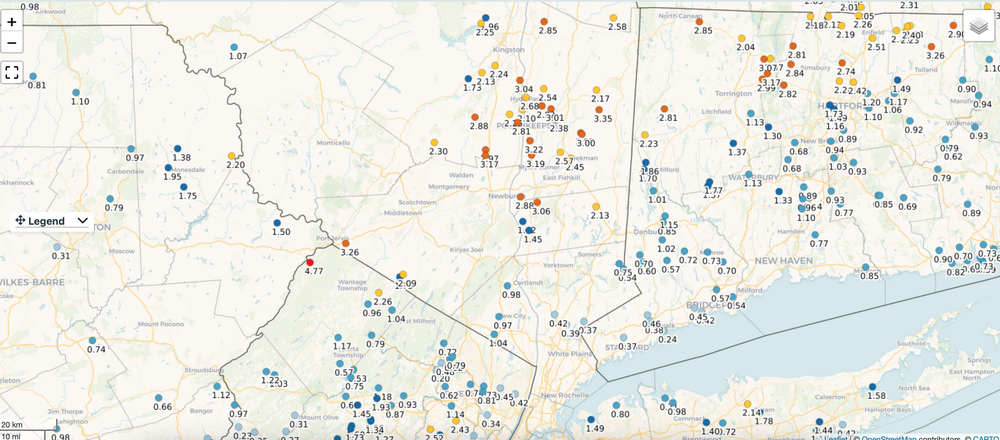
Heaviest rainfall in quick scan of weather underground data. Am sure more will come in soon... click of clarity. Ignore the 11.8. Not qc'd so amounts might be too high?\

-
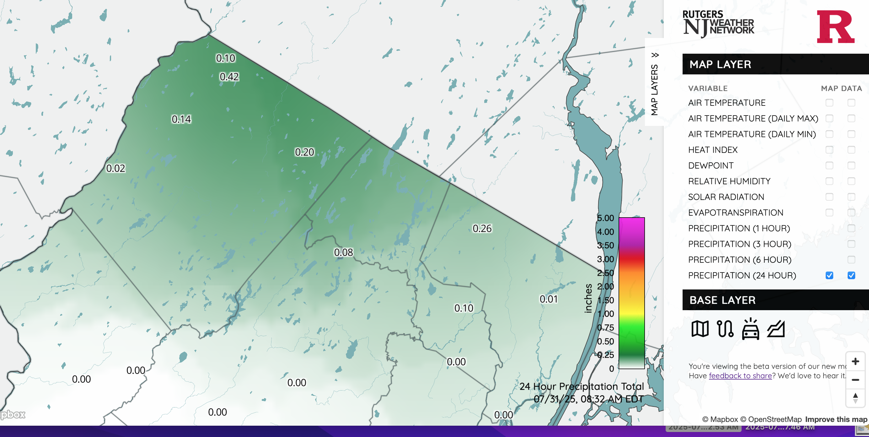
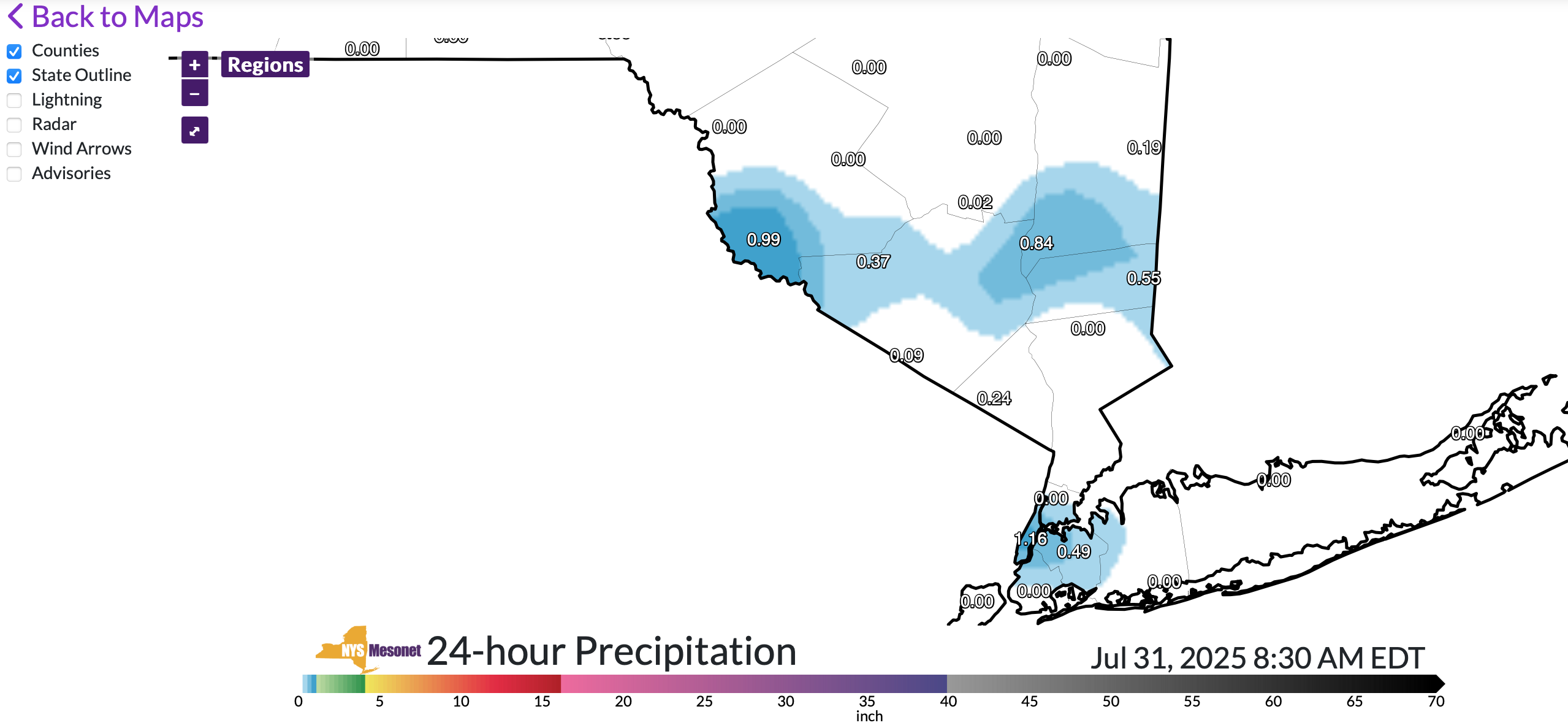
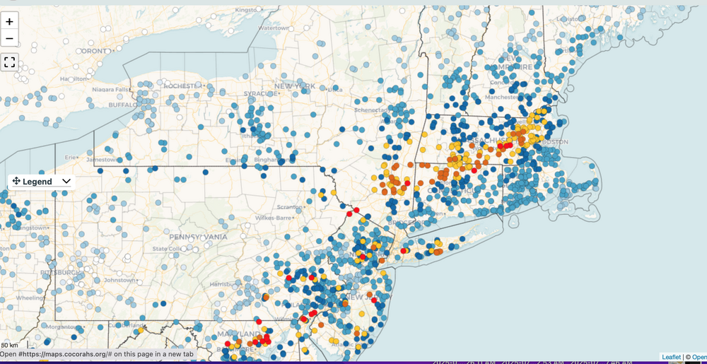
Sampling of rainfall in narrow groups-swaths roughly 2PM yesterday- 8AM this morning. Click for clarity. Interesting 15 hours ahead. At 838AM added the NJ and NYS climate mesonet 24 hours amounts.


-
To get this started brief heavy showers have dropped at least 1 to 3 tenths of an inch in far nw NJ and se NYS since 2PM.
-
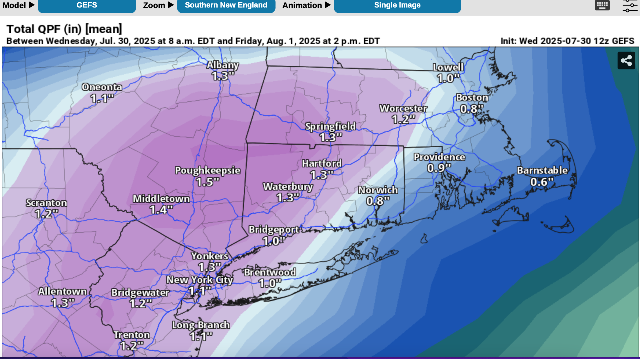
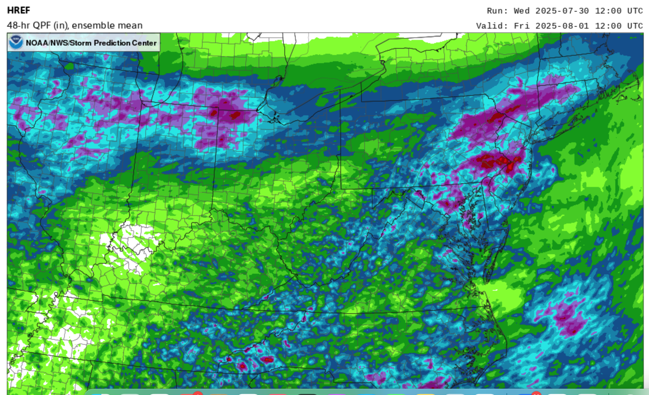
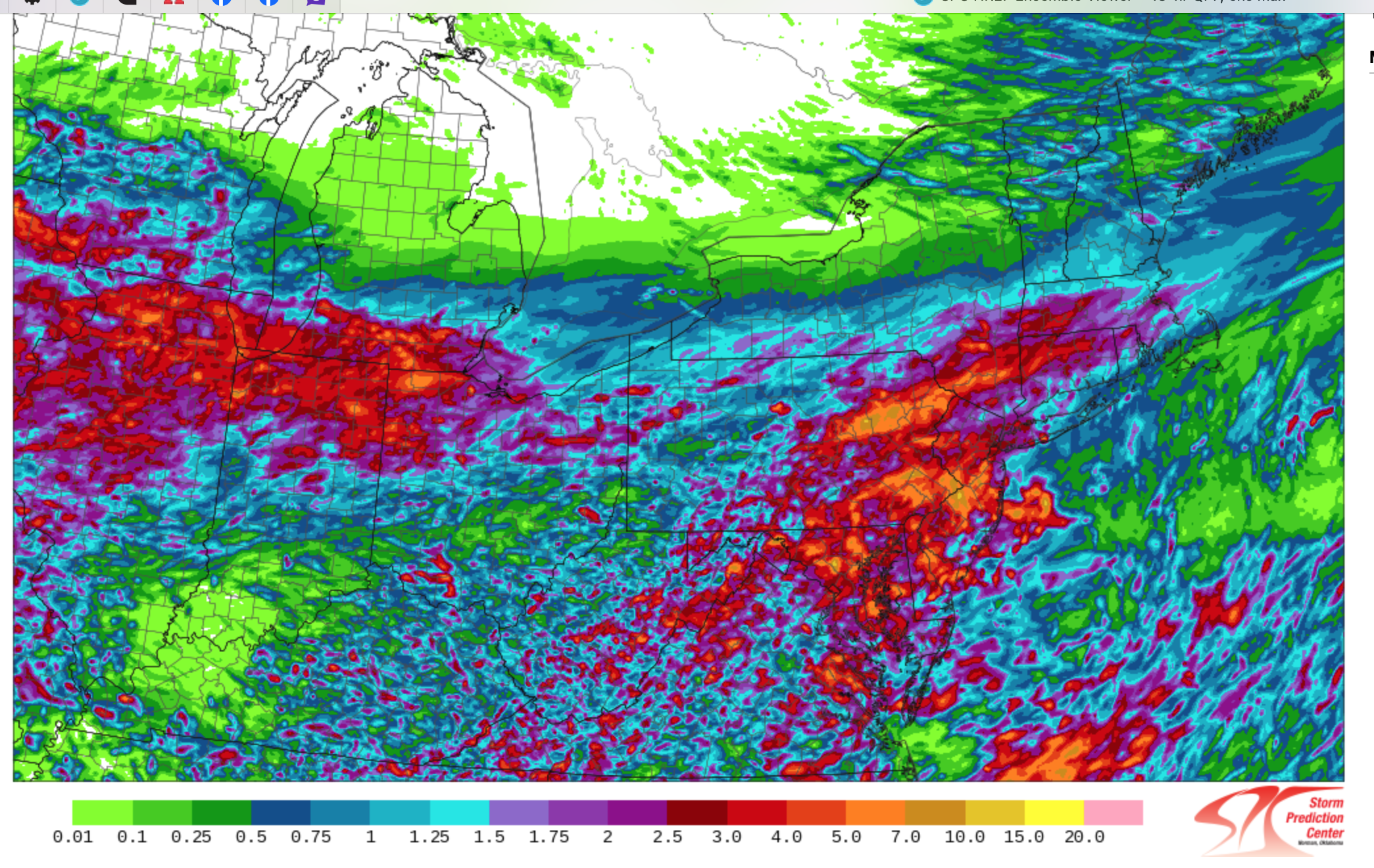
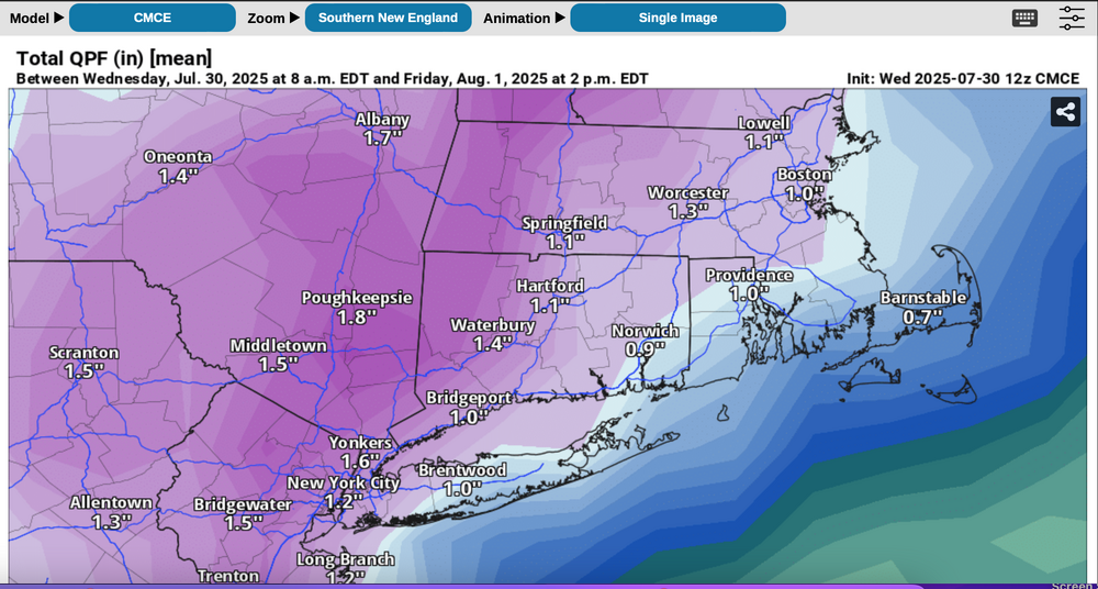
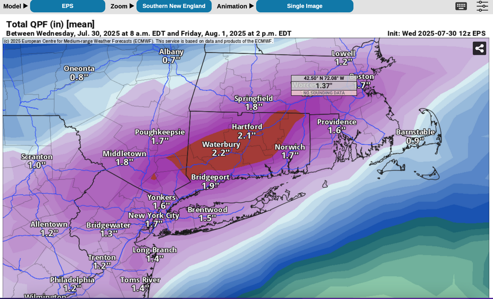
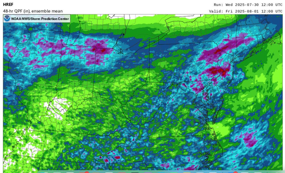
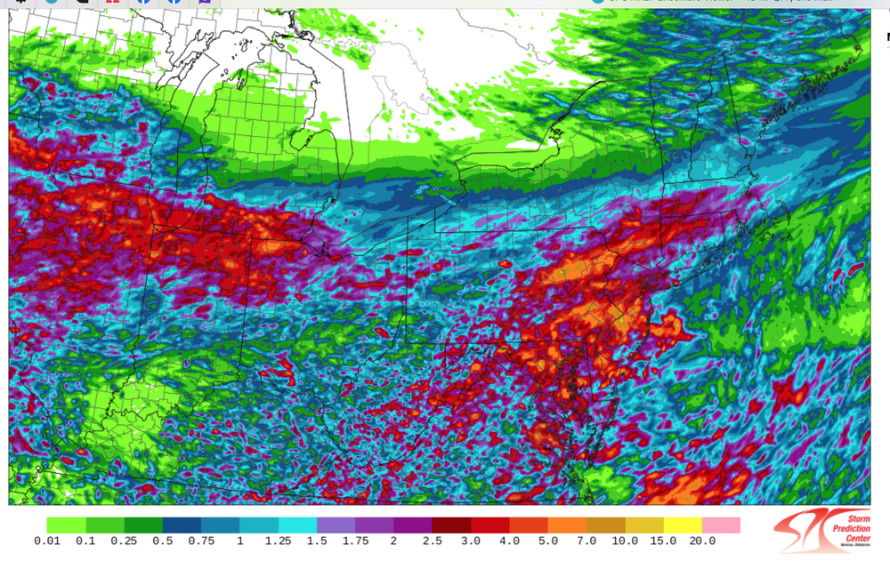
Follow NWS warnings-statements. A flood watch has just been issued by the NWS for a portion of the NYC subforum. I'd prepare for some delays Thursday-Thursday evening, possibly a few detours. If a road is flooded, don't cross it---turn around-done drown. Not worth the risk. We dont know where exactly 4+" of rain should occur but the potential exists as a slow moving frontal boundary possibly ends as a near northeast gale for LI. Plenty of PWAT (1.5"+) along with the RRQ of a strong confluence zone 5h-3H et across northern Maine-the Maritimes causes large scale overrunning of the southward sagging frontal boundary Thursday-Thursday night when the bulk of the heavy rain occurs. For now, it appears the region from I78 northward is vulnerable to excessive short fuse runoff but the HREF added graphic shows the isolated 7+ inches POTENTIAL(browns from the legend) just south and west of our NYC subforum. Nevertheless, this should be a somewhat interesting 48 hour period. For reference have added the 12z Wed 7/30 ensembles CMCE, EPS, GEFS as well as the 48 hour MEAN rainfall from the SPC HREF ending 12z Friday with magenta 1.5"+, and the MAX potential rainfall from the HREF which suggests isolated 7-possibly 10" but primarily southwest of the NYC subforum. See legend but dont take location verbatim and. dont necessarily believe 7+ can occur. Antecedent conditions are not excessively wet so large rivers are not likely to flood, but small streams, especially near urban areas could see overflow Flash Flood response.

-
July 2025 Discussion-OBS - seasonable summer variability
wdrag replied to wdrag's topic in New York City Metro
Heavy showers organizing E PA. SPC HREF seems to have spot 7" MAX potential by Thu evening. Waiting completion of the HREF and then probably starting a thread for iso FF, detours, travel delays...sometime between 4-8P. -
July 2025 Discussion-OBS - seasonable summer variability
wdrag replied to wdrag's topic in New York City Metro
Will make my final decision on an OBS-Discussion thread for the upcoming rainfall which I think may produce small pockets of FF within the general 3/4-4"---iso max of 6" I think is possible. Primary event Noon Thu-Noon Fri (16z/31-16z/1), but preceded north of I80 by scattered heavy showers/iso severe 4PM-10P (20z/30 -02z/31) today. Most vulnerable via variability in the modeling - cant be sure where to lock it in but for our subforum between I84 and I95. Todays 12z SPC HREF will be my primary guidance, along with other supporting modeling --HRRR etc. -
July 2025 Discussion-OBS - seasonable summer variability
wdrag replied to wdrag's topic in New York City Metro
IF NWS issues a flood watch, will start a thread. Its marginal right now but I expect more or less what WPC has posted this morning with isolated max rainfall of 6". No thread at this time.