wdrag
-
Posts
5,603 -
Joined
-
Last visited
Content Type
Profiles
Blogs
Forums
American Weather
Media Demo
Store
Gallery
Everything posted by wdrag
-
September 2025 OBS-Discussion centered NYC subforum
wdrag replied to wdrag's topic in New York City Metro
No thread from myself: Looks good for 1-3" I95 corridor iso 4. Few SVR 2P-8P. This welcomed rain will be a little further east than Friday. Rain ends W-E Sunday. -
September 2025 OBS-Discussion centered NYC subforum
wdrag replied to wdrag's topic in New York City Metro
No thread from myself: Looks good for 1-3" I95 corridor iso 4. Few SVR 2P-8P. This welcomed rain will be a little further east than Friday. Rain ends W-E Sunday. -
September 2025 OBS-Discussion centered NYC subforum
wdrag replied to wdrag's topic in New York City Metro
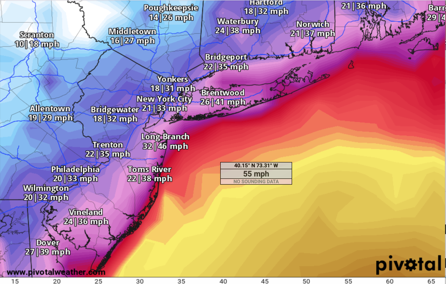
May start a thread at 630AM Saturday for OBS-NOWCAST fairly widespread svr and a few Possible FF along I95 corridor. Model trends important and so am not committed yet but I think we're going to be pretty interested in the activity, especially for SEPT. SVR threat seems larger than the FF due to the recent dryness on and east of I95. However NNJ - central NJ inside of I95... be on your toes and no hanging out on stream banks once this system gets going. There were very sharp rises (and falls) of small streams last evening . Might be more extreme tomorrow. Aquiet period Sat evening before the widespread moderate rains with embedded thunder occur overnight Sat. Eastern LI probably not too much til maybe e Sunday morning -
September 2025 OBS-Discussion centered NYC subforum
wdrag replied to wdrag's topic in New York City Metro
Other than the 12z/5 GGEM which looks pathetic against 12z/5 NAM, 06z/5 EC/EAAI, there will be an additional 1/2-3" of rain 16z Sat-16z Sun in NJ/LI/se NYS/CT,, especially near the Hud River and I95 corridor. You choose where. Point Pleasant wont miss though hard to say how much there. Too much backside vort after the initial squall line passes late Sat. Should rain decently overnight Sat into daybreak Sunday. Pretty sharp cool down Sat night. Tue-Wed looking a little more likely for cool coastal rain. Back later today. -
September 2025 OBS-Discussion centered NYC subforum
wdrag replied to wdrag's topic in New York City Metro
Follow HRRR and plan accordingly. It's going to rain at 430PM Saturday but where exactly is the wedding near PHI. For now, imo, the HRRR has been running a little slow on convection developing (certainly for this most recent event). For a number of reasons (AC - heat,/Thunder lightning wind threat), I'd advise indoors but that's your call. -
September 2025 OBS-Discussion centered NYC subforum
wdrag replied to wdrag's topic in New York City Metro
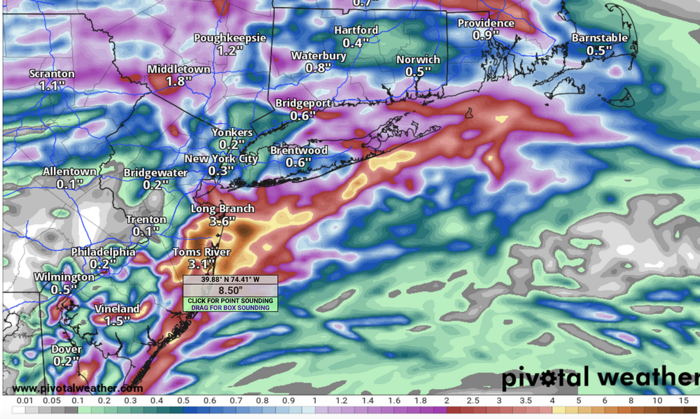
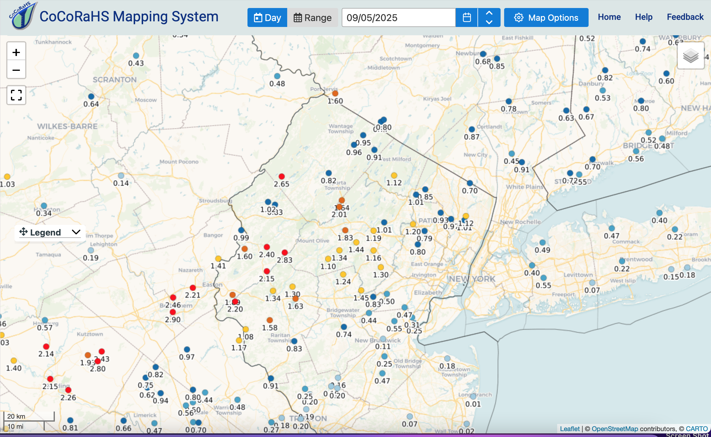
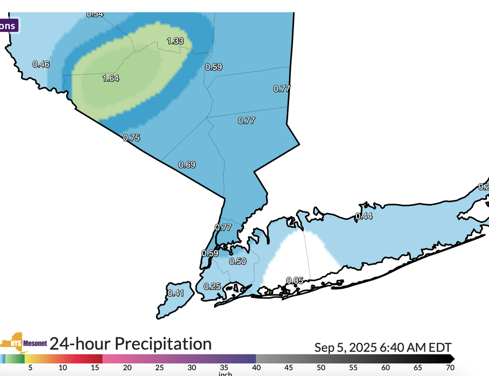
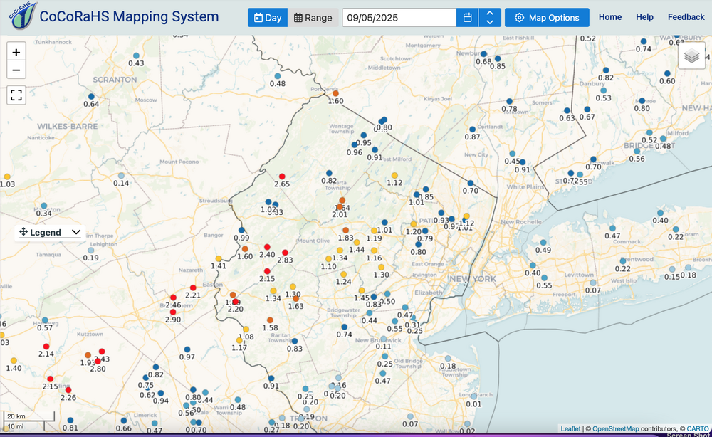
More yesterday from the 531AM PNS PHI. No PNSOKX on rainfall as of 948AM/5 ...Sussex County... Blue Mountain Lakes 3.14 in 0514 AM 09/05 RAWS Stanhope 2.40 in 0515 AM 09/05 AWS 4 WSW Wantage Twp 2.31 in 1040 PM 09/04 Trained Spotter 1 SW Hopatcong 1.91 in 0518 AM 09/05 AWS Montague 1.88 in 0515 AM 09/05 CWOP 0.7 NE Flatbrookville 1.64 in 0500 AM 09/05 HADS Wallkill River Nwr 1.49 in 0456 AM 09/05 RAWS Sparta 1.45 in 0520 AM 09/05 CWOP Sussex 1.30 in 0509 AM 09/05 ASOS LAFAYETTE 1.19 in 0520 AM 09/05 CWOP Stockholm 1.07 in 0513 AM 09/05 CWOP 2.3 N Stockholm 1.01 in 0445 AM 09/05 HADS ...Warren County... Hackettstown 3.10 in 0519 AM 09/05 AWS Broadway 2.49 in 0516 AM 09/05 CWOP Phillipsburg 2.00 in 0430 AM 09/05 COOP Belvidere 1.00 in 0515 AM 09/05 CWOP -
September 2025 OBS-Discussion centered NYC subforum
wdrag replied to wdrag's topic in New York City Metro
It seems that a FFA may be needed for the I95 corridor tomorrow afternoon-night, or possibly a little west of, despite the still normal or below normal stream flows. Presuming the NWS, which tends to be conservative and does not issue a FFA, then it wont surprise if an isolated FFW or two will be needed. PWAT larger than last night. Instability etc. Kids, they should not be playing along side streams in NNJ this morning or late Sat. All SPC HREF leading up to last nights event... POOR. Finally: midweek event for Tue night or Wed along the coasts is still in play but not counting on it. Need to focus on 16z Sat-16z Sunday. -
September 2025 OBS-Discussion centered NYC subforum
wdrag replied to wdrag's topic in New York City Metro
Added August final USA temp and qpf departures to p1 of August (Sept 5 2025 posting). -
September 2025 OBS-Discussion centered NYC subforum
wdrag replied to wdrag's topic in New York City Metro
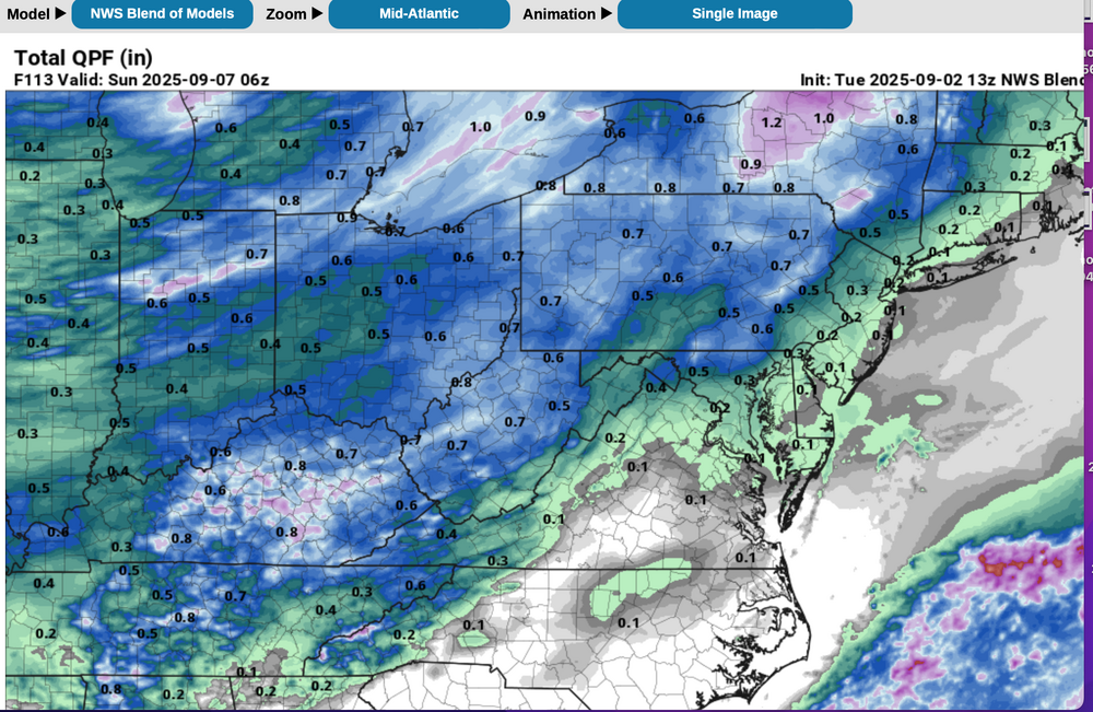
Final at Wantage NJ 4sw: 2.68". mostly 520P/4-1255A/5. Ambient (AWN) slightly higher at 2.77 but surprisingly close. Walt 730A. Sept 5, 2025 First event had .56" at CP. Other climate site info attached fm NJ, NYS and CoCoRaHs attached. Also attached the woeful BOM 113 hours in advance... PLEASE use the Blend of Models as a starting point but not as gospel. NWS I think starts with this and then decides whether to make changes. The next session of BOM finally got it better. Have to be careful relying on BOM. This pattern had the signals back in late August as in p1 of this Sept post including the CPC 6-10D and my 8/27 ensemble anticipation. Need to use ensembles... realizing that in CONVECTION--- the ensemble avg bleeds outward from the max axis... ensembling globals is not as accurate as mesoscale.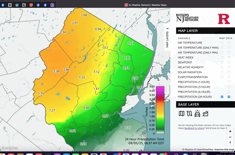
-
September 2025 OBS-Discussion centered NYC subforum
wdrag replied to wdrag's topic in New York City Metro
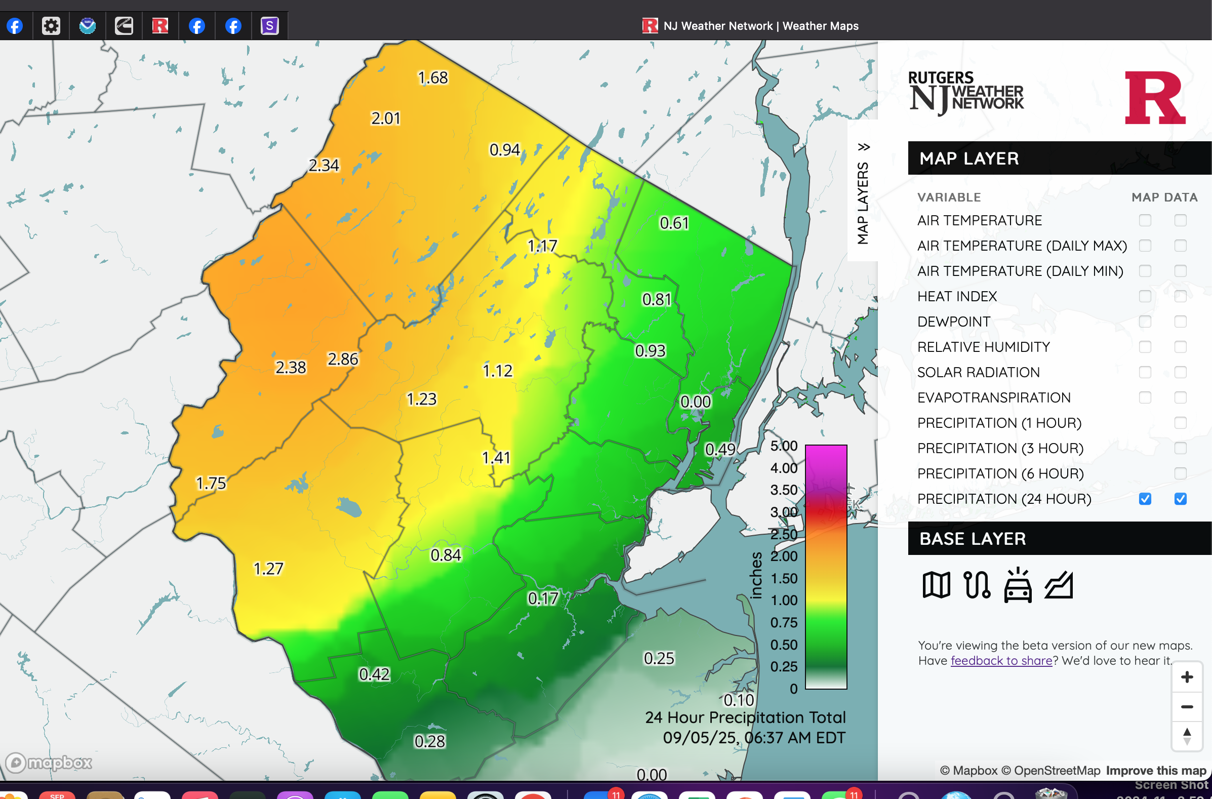
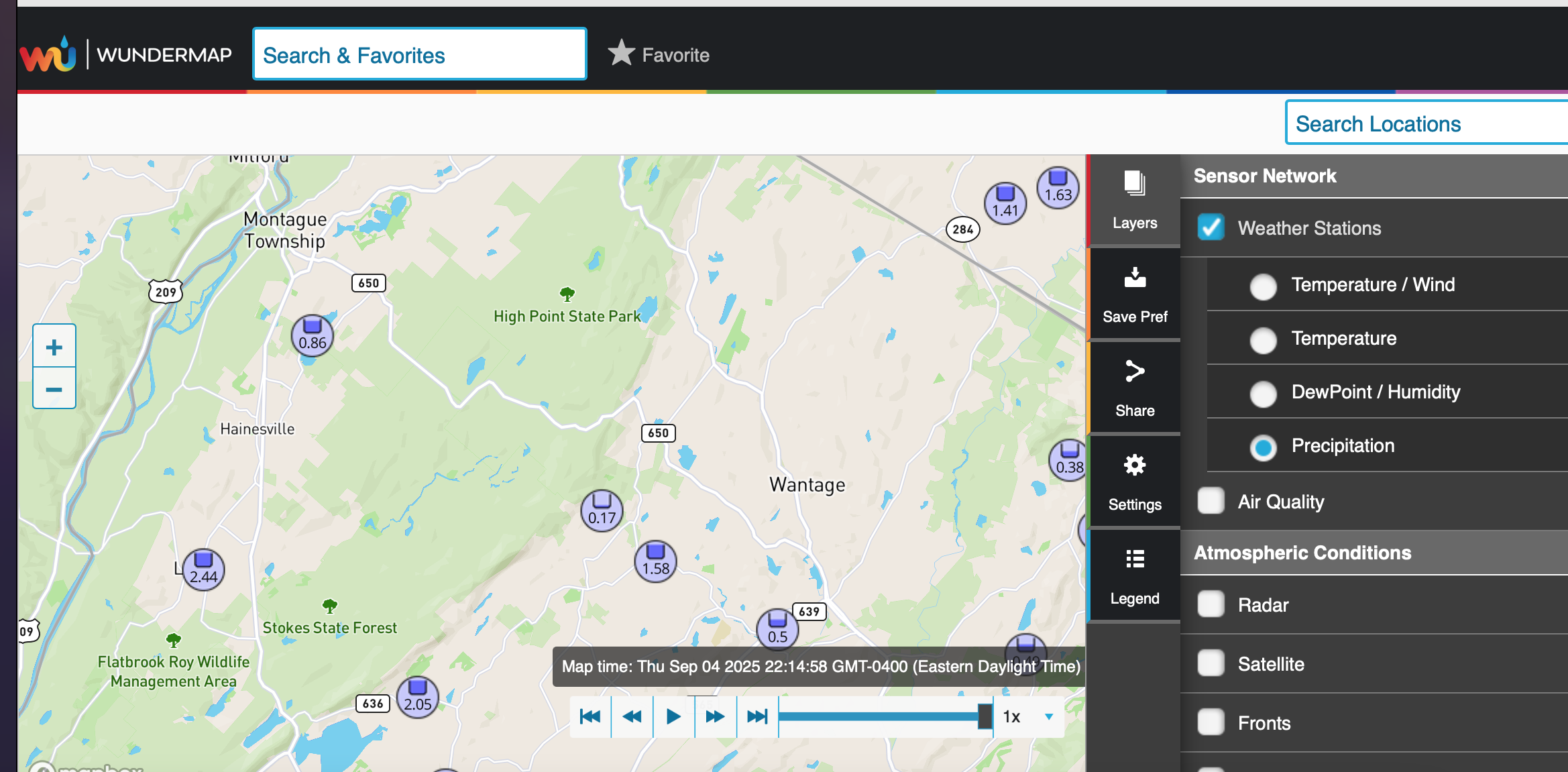
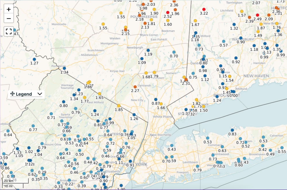
Here's some weather underground numbers in Sussex County and adjacent Orange County se NYS. These might be a tad high but I think 1.5-2" totals are reaL. My part of Wantage NJ on my Ambient reading 2.05. It cant handle intense rainfall rates an tips too much. I'll have a number inn the morning. Sort of surprised WPC and PHI have nothing out up here. Radarscope 1 hr and STP's look accurate. Been thundering here for at least 30 minutes per my dog Ollie barking (Cairn). Click for clarity.
-
September 2025 OBS-Discussion centered NYC subforum
wdrag replied to wdrag's topic in New York City Metro
Wantage NJ. Ambient says 1.91" and rising fast. Reality is less... probably 1.5" at least since 5P. Suspect there is going to be some flooding here in the hills of nw Nj and interior se NYS. -
September 2025 OBS-Discussion centered NYC subforum
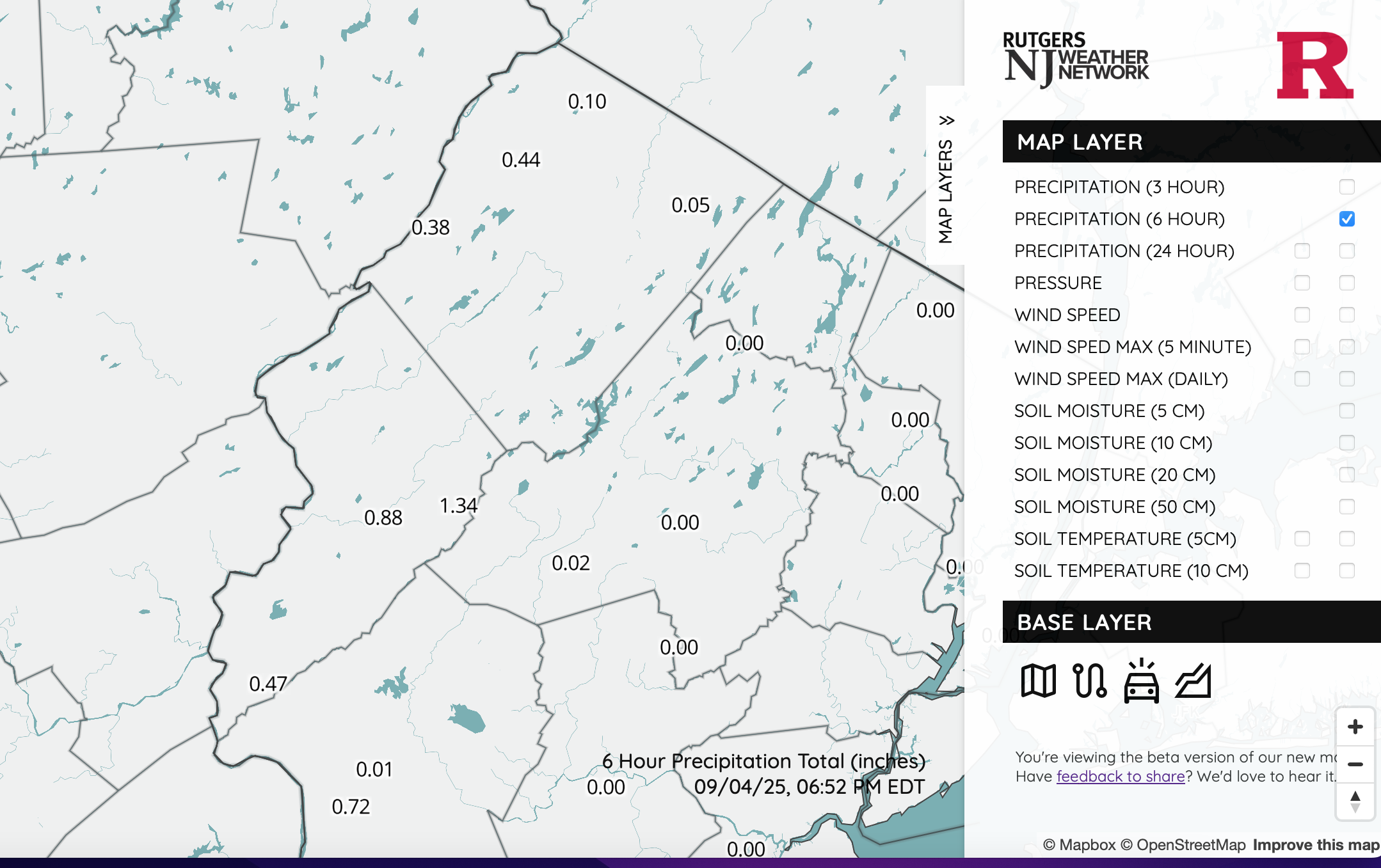
wdrag replied to wdrag's topic in New York City Metro
These NJ climate site #'s are correct... and match Radar Acopte Digital 1 hr and STP accums... .48 at my house in Wantage. Click image for clarity.
-
September 2025 OBS-Discussion centered NYC subforum
wdrag replied to wdrag's topic in New York City Metro
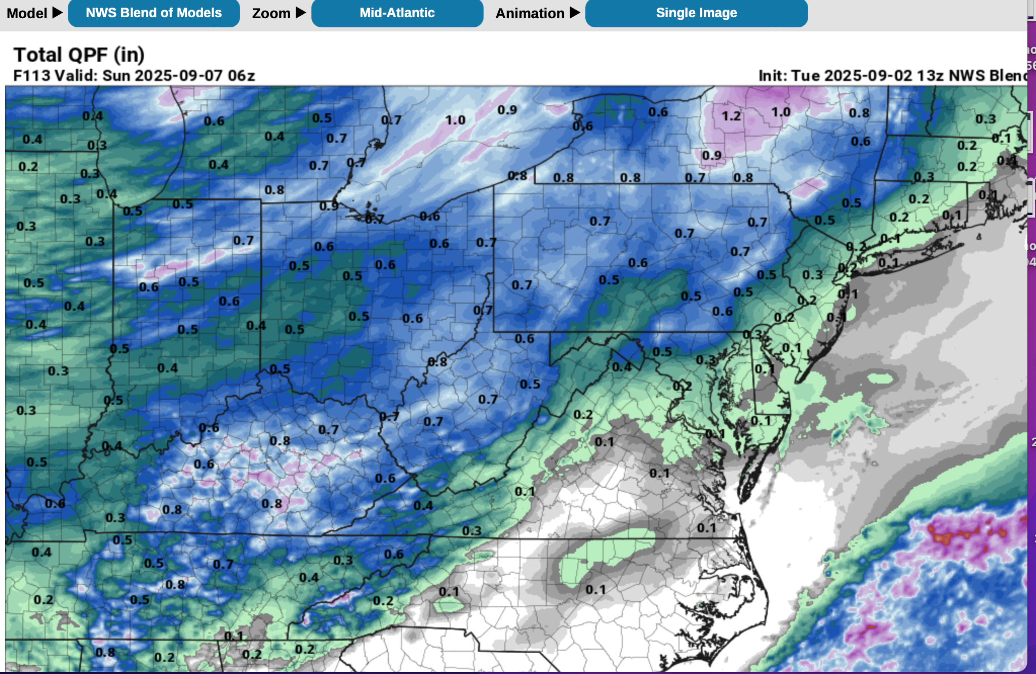
No timing insights. Periodic showers late Thu-Sunday. ALL 12z/3 global ensembles are continuing to increase amounts into the 1/2-spot 2" range I95 west and less east . So the dry stats may pan out accurate (dry stats for CP), but I have to go with dynamics and until I see all the modeling fade, I'll believe heavier than WPC's 12z/3 capped 1/3rd inch. Weak frontal event Thu night. Front hangs back Fri... next Event(s) this weekend as new frontal system approaches and slowly passes through during the weekend. Timing of convection and the marginal instability are factors to consider. Next week may? get interesting (Sep 10-15). Ensembles already baggy trough along eastern seaboard at 5H. -
September 2025 OBS-Discussion centered NYC subforum
wdrag replied to wdrag's topic in New York City Metro
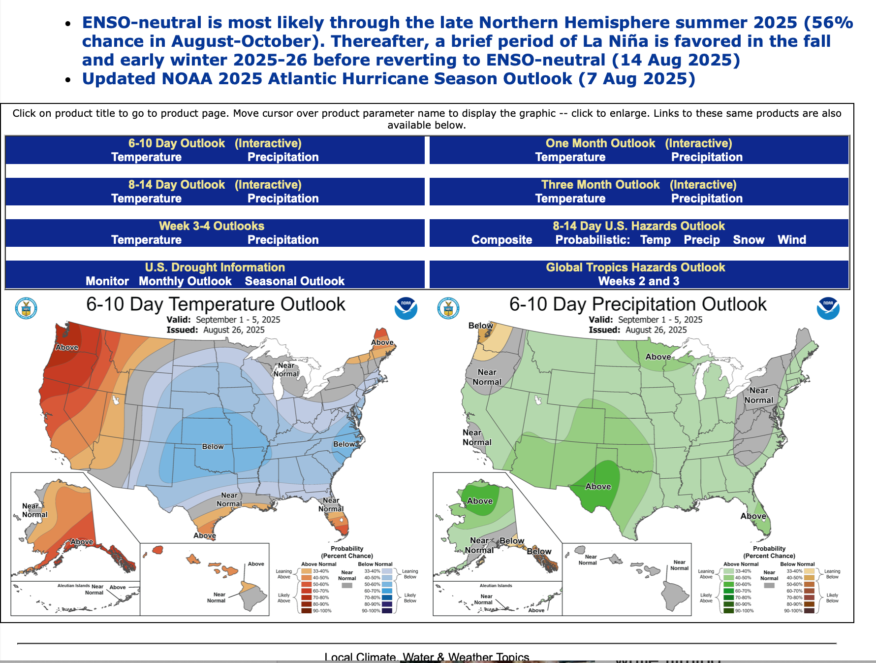
In the meantime, I like how this coming week is shaping up for rainfall. Won't uprise if sct light showers develop Tue or Wed, and think WPC is too conservative by 1/2" on its total week 1 forecast (00z/30 cycle) for our NYC subforum. Am in the 1/2-2" bracket for starters between Thu-Sat. Have a day. Thanks Don for the Sep stats earlier this thread and Bluewave for the continuing updates on temp stats. The new monthly outlook by CPC.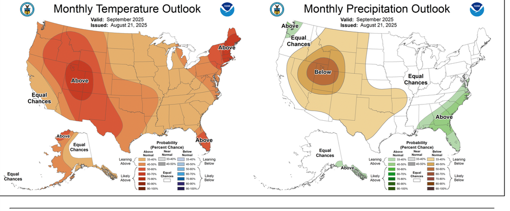
-
September 2025 OBS-Discussion centered NYC subforum
wdrag replied to wdrag's topic in New York City Metro
Well reviewed. I can’t quibble. Main thing for favorable decent event is a southern short wave separation from northern Jet, eventually shoving northeast. That option is still there if it’s weak then not so good for rain. WPC starting to show rainfall D7 and CPC with new 6-10 D outlooks etc around 3-4p -
September 2025 OBS-Discussion centered NYC subforum
wdrag replied to wdrag's topic in New York City Metro
at least you got your surprise .20 two nights ago... we've traced the past couple of afternoon-evenings. I didnt check CoCoRaHs and the Mesonet climate sites but am sure there were some meager amounts. Grandsitting another day or two. -
September 2025 OBS-Discussion centered NYC subforum
wdrag replied to wdrag's topic in New York City Metro
Updated 654A/28: I am seeing a probable approximate 1/2-2" rain event or periodic rains between Tue and Sat of next week. 00z/28 Ensembles coming into agreement with fairly substantial high amplitude troughing near and west of 80W longitude the middle of next week. Who gets 2 and who gets relatively meager 1/2" far too early but finally in my viewer assembling, a more widespread event appears on the distant ensemble horizon. The 2" reference is not necessarily the high end. -
September 2025 OBS-Discussion centered NYC subforum
wdrag replied to wdrag's topic in New York City Metro
fwiw...5H pattern is looking interesting for me here as of the 06z/27 ensembles. my interest is west of I95 where it's been pretty darn dry since the 22nd. Am I seeing opportunity for for 1/2-2" of rain in nw NJ next week beginning periodically Monday night Sept 1? -
Sept thread started... this above added to Sept.
-
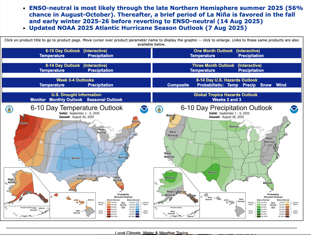
Am not using GEFS predictors etc beyond 2 weeks and messing up the anticipation mid month onward, like the August 2025 post. Instead I've added the 6-10 day issued yesterday, as well as the page you can go to look at CPC's daily updates of 6-10, 8-14 day, the weekly Friday updates of the 2-3 week and twice monthly updates of the monthly outlook, as well as other occasionally helpful predictors, based on the still nascent developing long ranging science beyond 2 weeks. https://www.cpc.ncep.noaa.gov
-
If all goes well I'll get Sept thread started by 8PM. fwiw...5H pattern is looking interesting for me here, west of I95 where it's been pretty darn dry since the 22nd. Am I seeing opportunity for for 1/2-2" of rain in nw NJ next week beginning periodically Monday night?
-
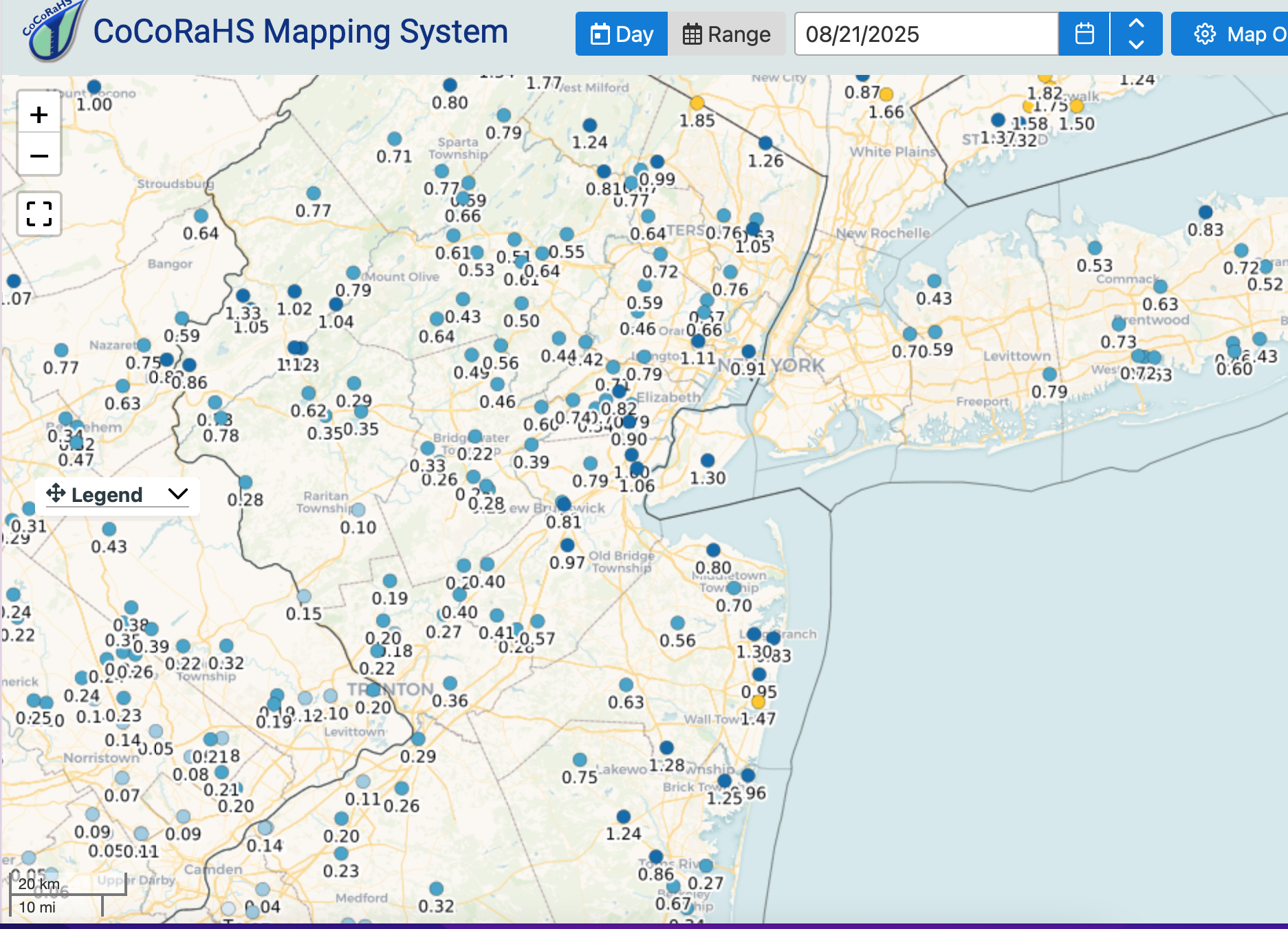
fwiw on Erin along he NJ coast per PHI PNS yesterday... I added this in, cause I didnt see it posted. If I erred, I apologize. Public Information Statement National Weather Service Mount Holly NJ 703 PM EDT Thu Aug 21 2025 ...HIGHEST WIND REPORTS... Location Speed Time/Date Provider ...Delaware... ...Sussex County... Dewey Beach 46 MPH 1136 AM 08/21 WXFLOW Lewes NOS 43 MPH 1136 AM 08/21 NOS-NWLON Lewes 43 MPH 1142 AM 08/21 WXFLOW Rehoboth Beach 42 MPH 1134 AM 08/21 AWS Rehoboth Beach 42 MPH 1205 PM 08/21 DAVIS Indian River Bay Dewey Beach 41 MPH 1145 AM 08/21 DEOS2 Georgetown 40 MPH 1105 AM 08/21 ASOS ...New Jersey... ...Atlantic County... Atlantic City 46 MPH 0230 PM 08/21 NJWXNET BRIGANTINE 41 MPH 0444 PM 08/21 CWOP 1 NE Brigantine 41 MPH 0449 PM 08/21 Public ...Cape May County... Cape May 44 MPH 1235 PM 08/21 DAVIS 1 NW Wildwood 42 MPH 1239 PM 08/21 Public Ocean City 41 MPH 1115 AM 08/21 CWOP Ocean City 41 MPH 1157 AM 08/21 WXFLOW ...Monmouth County... Keyport 48 MPH 0524 AM 08/21 CWOP ...Ocean County... Surf City 49 MPH 0245 PM 08/21 Public 2 S Island Beach State Park 48 MPH 1014 AM 08/21 Public Rutgers 45 MPH 0323 PM 08/21 WXFLOW Tuckerton 44 MPH 0149 PM 08/21 WXFLOW Seaside Heights 43 MPH 0817 AM 08/21 WXFLOW Harvey Cedars 43 MPH 0235 PM 08/21 NJWXNET South Seaside Park 40 MPH 0817 AM 08/21 CWOP Holgate 40 MPH 1019 AM 08/21 Public Beach Haven 40 MPH 1021 AM 08/21 CWOP Trixies 40 MPH 1137 AM 08/21 WXFLOW ...Delaware... ...Maritime Stations... 19 E Fenwick Island 45 MPH 0229 PM 08/21 Buoy 1 ENE Lewes 42 MPH 1136 AM 08/21 Buoy ...New Jersey... 9 WNW Cape May Point 45 MPH 1048 AM 08/21 Buoy 1 NNE Brigantine 44 MPH 0259 PM 08/21 Public Sea Bright 43 MPH 0409 AM 08/21 Public &&
-
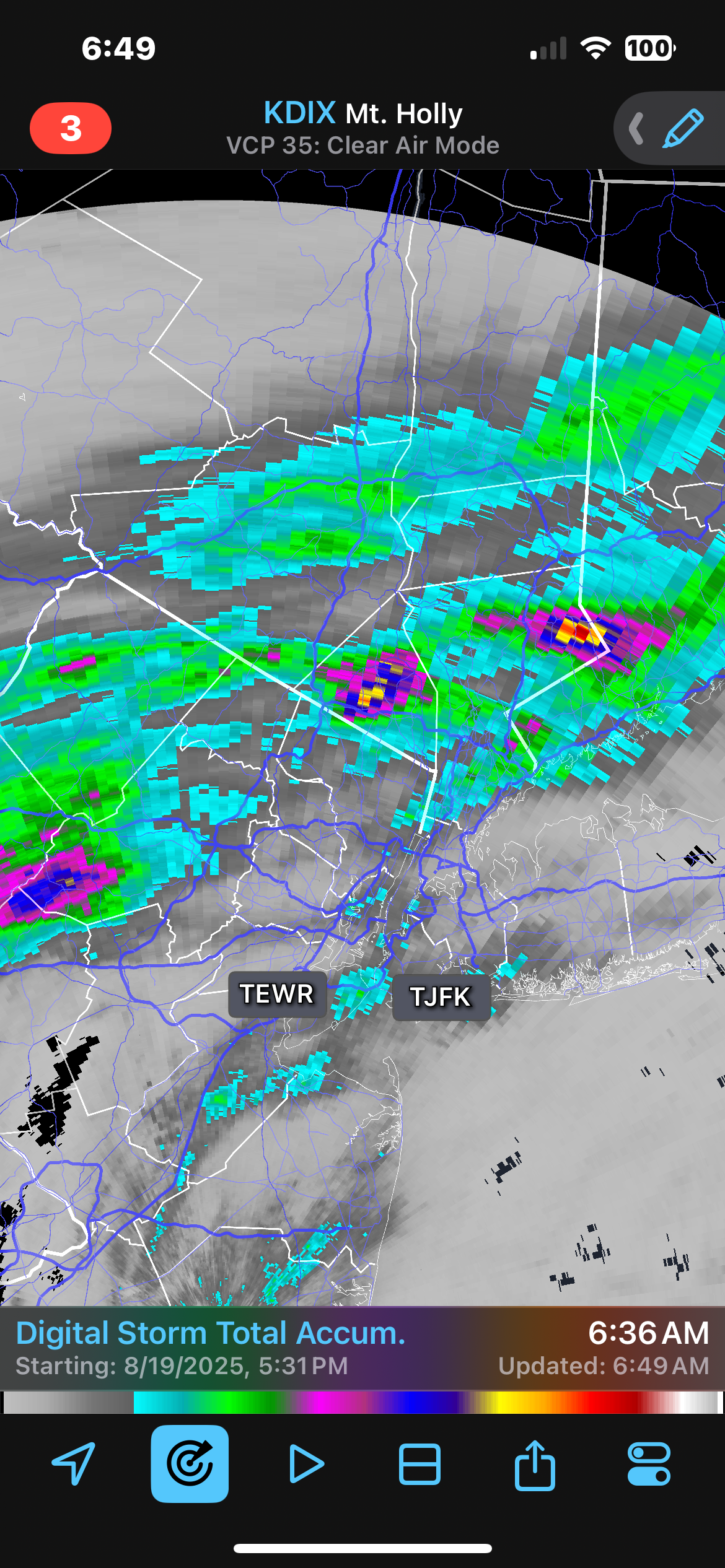
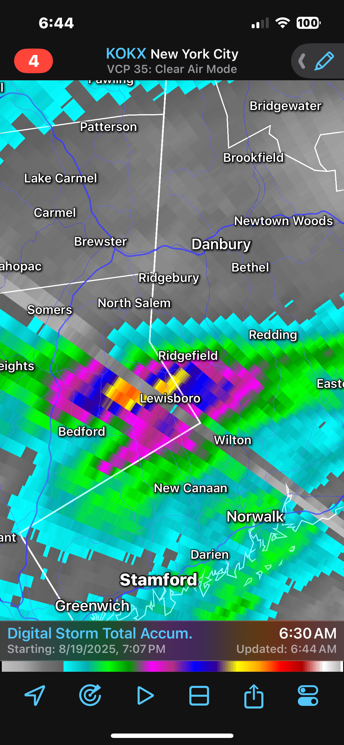
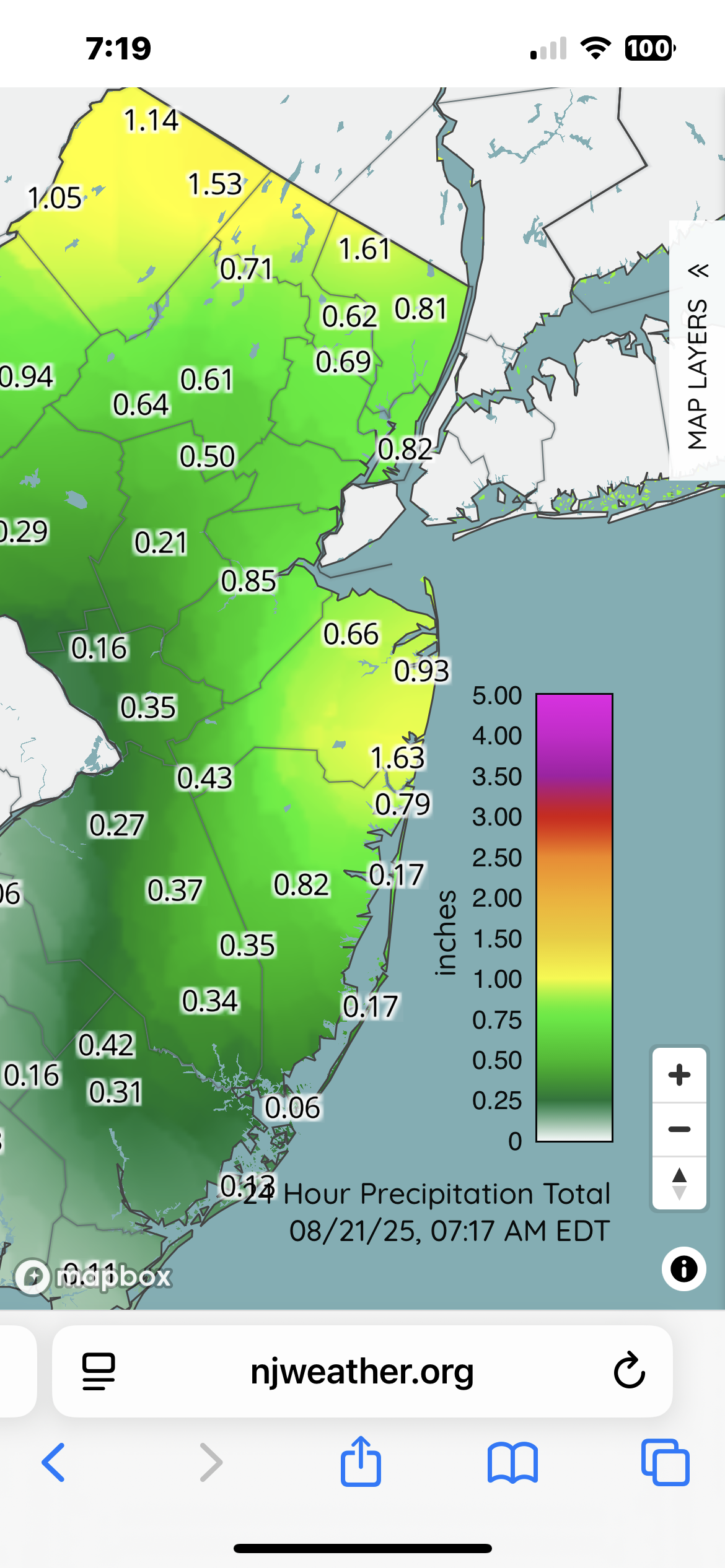
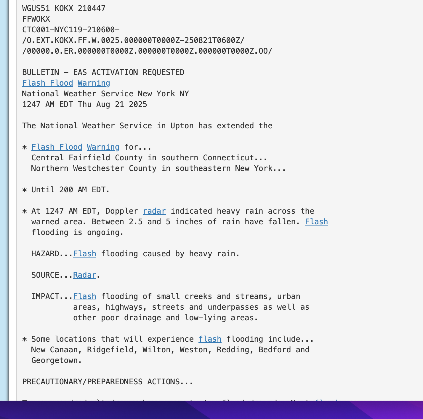
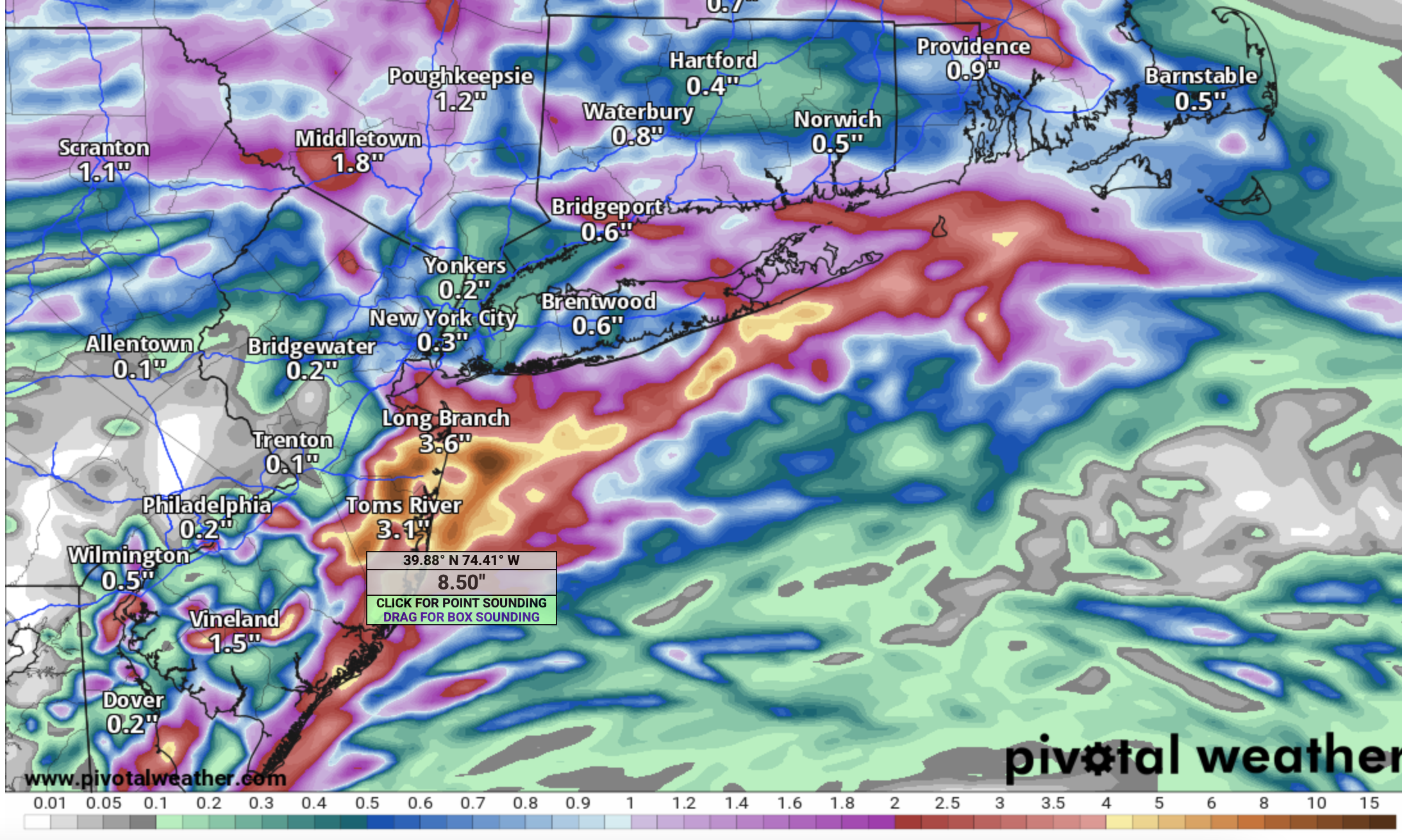
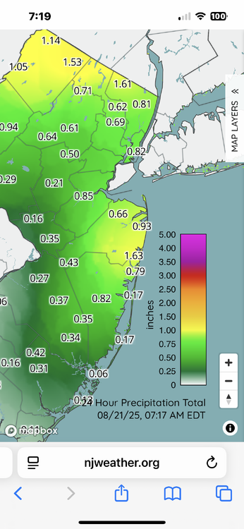
Kind of embarrassing for the GEFS/CMCE early Monday morning guidance that was relied upon for the WPC dry product for Wednesday 8/21. Our p45 815AM post had it all documented, with the EPS suite clearly indicating something along the lines of what happened. It's not always EPS/EC superior to the GFS suite but I am getting disappointed. Had this been winter, I think the forum would have been lit with posts. As it was, this snuck by... possibly most not caring, despite science allowing for consideration. No doubt the was a meaningful rain for all of us, alleviating some of the recent summer dryness. The rainfall accumulation graphics attached demonstrate. Also, while not a clear cut PRE, this qpf event was well in advance of Erin-an indirect influence on what happened here as you well know from watching radar. The PRE composite was helpful for me as meteorologist, attempting to gauge what might happen in our NYC subforum. MESOSCALE excesses: DID happen in se NYS and se CT, per attached NYC FFW, attached digital rainfall output which showed the 5" max, AND, weather underground two day report of 4.89" near Boutonville NYS (Old Post Rd) via station KNYSOUTH137. I did not check many stations there but you can get the drift. I have to clear some attachments so the attachments will complete at 915A and the attached at 915AM may not be in correct order, but if you're interested check all of this information presented. My house in Wantage NJ only 1.04 11A/20-6A/21.


-
Not threading but will be interesting this afternoon-tonight. from my view of multi modeling...one axis of potential excessive is near I90 to ne CT-RI, and a secondary axis from Monmouth-Ocean Counties to e LI. Whether out NYC subforum sees isolated 2-5", I'm unsure so no thread. Will post the 24 hour amounts via CoCoRaHs around 845A Thursday.
-
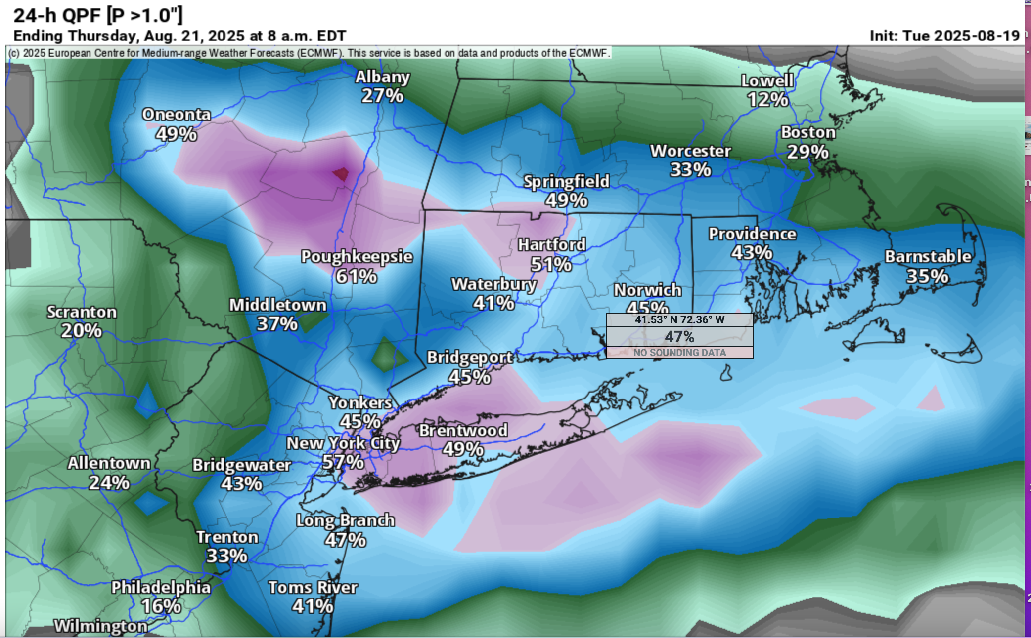
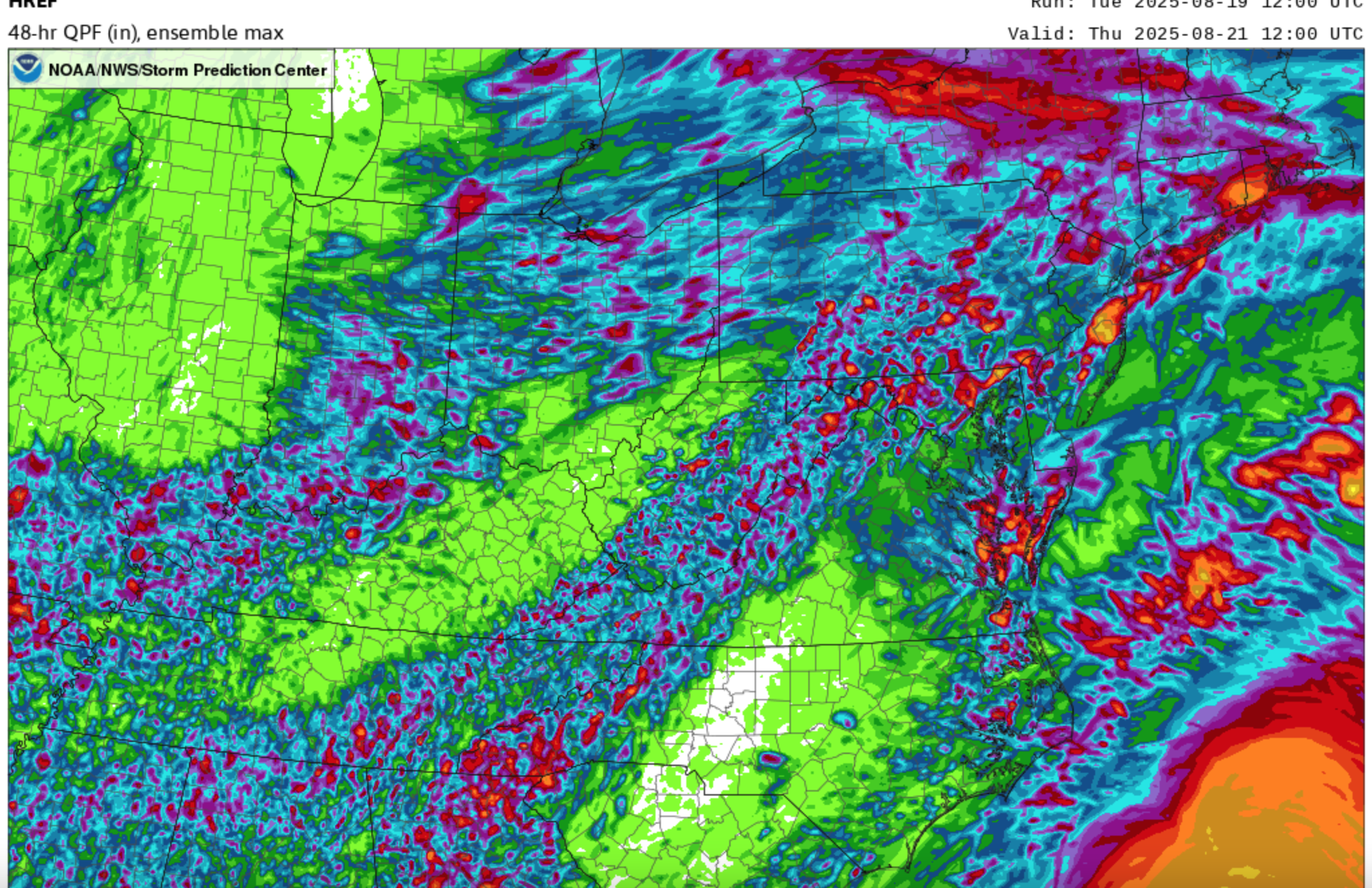
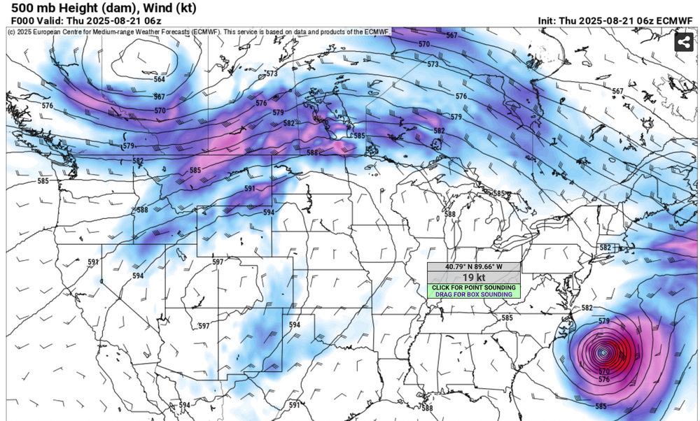
Follow NWS-NHC. Will hold off thread due to uncertainty locating 5"+ bands but I think we're looking at some surprise heavy amounts (2-5") late Wed-early Thu but where. Will rereview this evening and again tomorrow morning for a more a confident expression of bands Erin indirect but I think related heavy rain. For now the ensembles are generalized-spread out. EC/EPS/ECAI have been onto this for quite a few cycles. Here's some graphics: EPS 12z/19 prob of 1"+ 24 hr amount by Thu AM. I think its within these magenta 50% prob that iso 5+ will occur. For now it's a marginal risk from WPC on FF rain. SPC HREF has iso 5-7"+ MAX POTENTIAL rain in the tan areas including coastal NJ 12z EC OP has been slipping swd with the max axis rainfall but it's very close to our area off of s LI to coastal NJ...see the graphic. Finally, how about the EPS Max 6hr G ending 2A Friday showing TS gusts in our ocean waters, even possibly grazing the NJ shore. This is as far northwest as I've seen on the EPS which creeps our way... follow NHC/NWS. All other modeling is seaward and not as threatening. Follow NHC assessment-thank you. So there 18z NAM12K/NAM 3K like GEFS-CMCE... I90 NYS-MA Not a confidence booster for locating near 5" axis as seen on the 18z NAM3K. No thread yet. Rechecking tonight and Wed AM. 432P/