

bluewave
-
Posts
36,692 -
Joined
-
Last visited
Content Type
Profiles
Blogs
Forums
American Weather
Media Demo
Store
Gallery
Everything posted by bluewave
-
1985-2014 annual 30 year average number of 90 degrees per site: EWR...27 NYC....17 LGA....19 JFK.....10
-
Here's the update on 90 degree days going back to 1984: 90 degree days Year..EWR....NYC....LGA.....JFK 84...22...10...9...13 85...11....9....8....5 86...22...11...9...8 87...37...22...19..11 88...43...32...26...14 89...27...16...17...9 90...26...12...10...6 91...41...39...26...13 92...22.....9...9......6 93...49...39...26...13 94...39...19...22...7 95...33...29...23...15 96....8.....3.....6....4 97...20...12...17...10 98...21.....8....11....5 99...33...27...26....14 00...16....7.....12.....6 01...22...15...17.....8 02...41...32....35...21 03...20....8...17.....12 04...13...2.....7.......1 05...37...23...30.....17 06...26...8....22......12 07...21..10...23.......7 08...22...12...19......9 09...14....7.....8.......6 10...54....37...48.....32 11...31...20...19.....13 12...33...19....28....16 13...25....17....21....9 14...15....8......6.....2
-
Islip hit by the meteorological hat trick in the last half-year
bluewave replied to tmagan's topic in New York City Metro
http://www.nws.noaa.gov/oh/hdsc/aep_storm_analysis/11_Islip_2014.pdf Exceedance Probability Analysis for the Islip, NY Rainfall Event, 13 August 2014 Hydrometeorological Design Studies Center National Weather Service National Oceanic and Atmospheric Administration 1325 EastWest Highway, Silver Spring, MD 20910 Email: [email protected] Updated: 22 August 2014 The Hydrometeorological Design Studies Center (HDSC) analyzed annual exceedance probabilities (AEPs) for the Islip, NY rainfall event that occurred on 13 August 2014. AEP is probability of exceeding a given amount of rainfall at least once in any given year at a given location. It is an indicator of the rarity of rainfall amounts and is used as the basis of hydrologic design. The Islip event delivered rainfall amounts that exceeded 11 inches in 3 hours in some locations, causing extreme flash flooding. The rarity of this event is illustrated in two figures below. Figure 1 shows how the maximum observed rainfall amounts compared to corresponding rainfall frequency estimates for AEPs from 1/2 (50%) to 1/1000 (0.1%) for durations from 30 minutes to 72 hours for a rain gauge in the Islip area KISP, MacArthur Airport (40.7939°N, 73.1017°W, 98 ft elevation). The KISP gauge is part of the Automated Surface Observing System (ASOS). The AEPs are preliminary estimates from unpublished NOAA Atlas 14, Volume 10, Version 1 and may differ from final estimates, which will be released in 2015. The upper bound of the 90% confidence interval for 1/1000 AEP is also shown in the figure to illustrate uncertainty associated with the calculation of AEPs, which increase as the AEP becomes smaller. As can be seen from Figure 1, probabilities are less than 1/1000 for durations between 45min and 24hour. Both 2hour and 3hour amounts exceed the upper bound of the 90% confidence interval of corresponding 1/1000 estimates. -
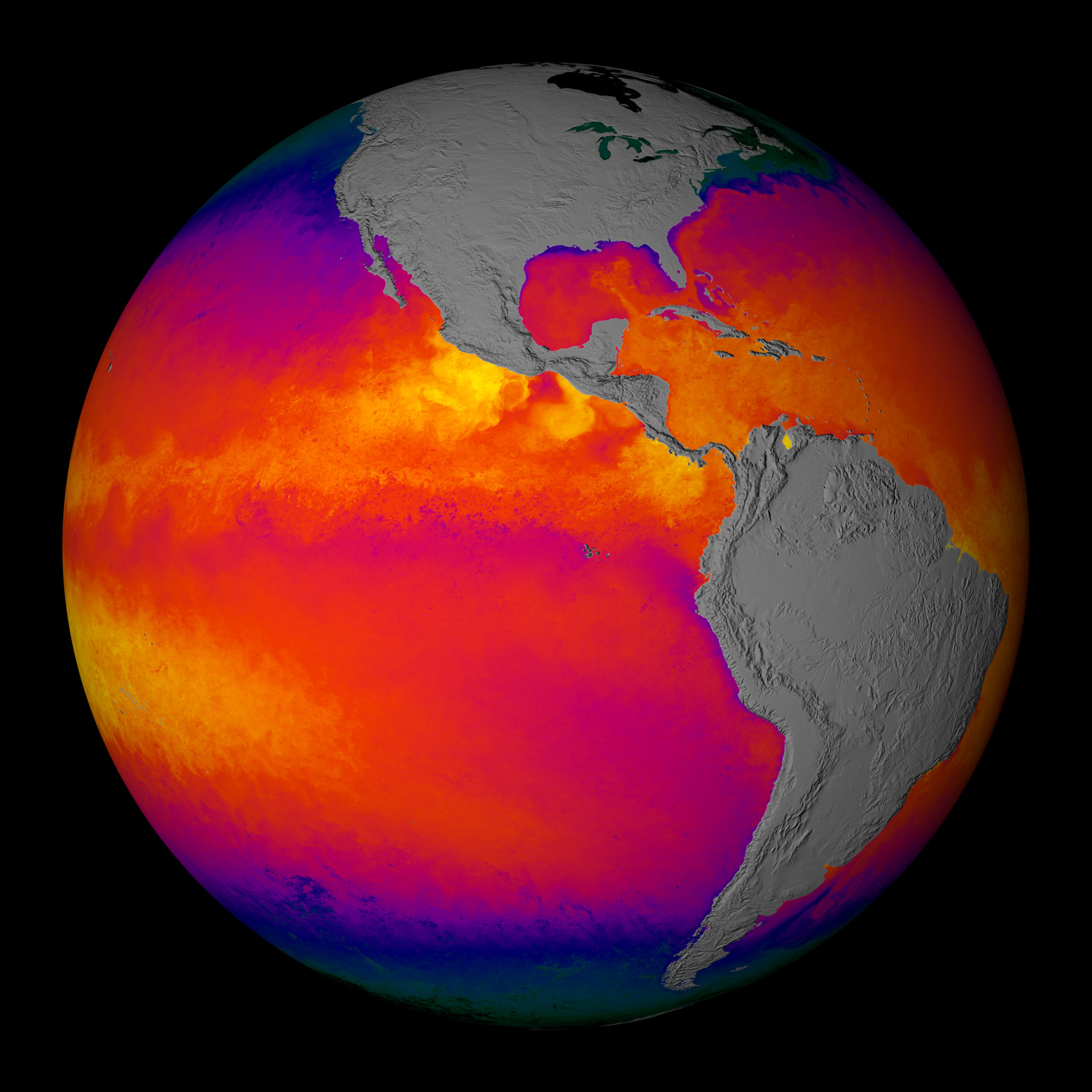 A new study just out addresses how the PDO can impact global temperatures on a decadal timescale. http://www.climatecentral.org/news/why-the-globe-hasnt-warmed-much-for-the-past-decade-15788 The natural variation in this case appears to be changes in wind patterns associated with the Pacific Decadal Oscillation, or PDO, a gradual see-sawing of ocean surface temperatures and wind patterns that goes through warm and cold phases lasting several decades. (The more familiar El Nino/La Nina oscillation, by contrast, see-saws every few years). According to Trenberth and his colleagues, deep ocean temperatures began to rise significantly starting in about 2000, at about the same time as trade winds in the Pacific were changing in strength, in turn affecting ocean currents, all very plausibly as a result of a shift in the PDO. http://www.skepticalscience.com/new-research-confirms-global-warming-has-accelerated.html This study builds on another paper published in 2011. http://www.cgd.ucar.edu/cas/Staff/Fasullo/my_pubs/Meehl2011etalNCC.pdf There have been decades, such as 2000–2009, when the observed globally averaged surface-temperature time series shows little positive or even slightly negative trend1 (a hiatus period). However, the observed energy imbalance at the top-of-atmosphere for this recent decade indicates that a net energy flux into the climate system of about 1 W m−2 7 (refs 2,3) should be producing warming somewhere in the system4,5 . Here we analyse twenty-first-century climate-model simulations that maintain a consistent radiative imbalance at the top-of-atmosphere of about 1 W m−2 as observed for the 11 past decade. Eight decades with a slightly negative global mean surface-temperature trend show that the ocean above 300 m takes up significantly less heat whereas the ocean below 300 m takes up significantly more compared with non-hiatus decades. The model provides a plausible depiction of processes in the climate system causing the hiatus periods, and indicates that a hiatus period is a relatively common climate phenomenon and may be linked to La Niña-like conditions. The time series of globally averaged surface temperature from all five climate-model simulations show some decades with little or no positive trend (Fig. 1a), as has occurred in observations (Supplementary Fig. S1 top). Running ten year linear trends of globally averaged surface temperature from the five model ensemble members reveal hiatus periods (Fig. 1a) comparable to observations (Supplementary Fig. S1 middle). Using the first ensemble member as an example, the overall warming averaged over the century is about +0.15 ◦ C per decade. However, the decades centred around 2020, 2054, 2065, 2070, and several decades late in the century show either near zero or slightly negative trends in that ensemble member. We choose two ten year periods in this ensemble member when the globally averaged surface temperature is negative, that is, less than −0.10 ◦ C over the decade (Fig. 1a), and six similar periods that meet the same criterion from the other four ensemble members, to form an eight-member composite of hiatus periods. http://www.sciencedaily.com/releases/2011/09/110918144941.htm To track where the heat was going, Meehl and colleagues used a powerful software tool known as the Community Climate System Model, which was developed by scientists at NCAR and the Department of Energy with colleagues at other organizations. Using the model's ability to portray complex interactions between the atmosphere, land, oceans, and sea ice, they performed five simulations of global temperatures. The simulations, which were based on projections of future greenhouse gas emissions from human activities, indicated that temperatures would rise by several degrees during this century. But each simulation also showed periods in which temperatures would stabilize for about a decade before climbing again. For example, one simulation showed the global average rising by about 2.5 degrees Fahrenheit (1.4 degrees Celsius) between 2000 and 2100, but with two decade-long hiatus periods during the century. Metoffice decadal forecast using a similar theme: http://www.metoffice.gov.uk/news/releases/archive/2013/decadal-forecasts http://www.metoffice.gov.uk/research/climate/seasonal-to-decadal/long-range/decadal-fc http://www.metoffice.gov.uk/research/news/decadal-forecasting
 -
Islip hit by the meteorological hat trick in the last half-year
bluewave replied to tmagan's topic in New York City Metro
I believe that this may have been one of the only tornadoes known to impact Islip while moving NNE and forming south of Long island. It seems like most Western to Central Suffolk tornadoes have more of an easterly heading and track along warm fronts or sea breeze boundaries. There was also another Tornado to impact Breezy point early in September that formed south of Long island with the very warm SST's. The magnitude of the snowfall at Islip may have been considered a 100 year event, and it would be interesting to see the specific numbers on that. The sharp turn to the left of Hurricane Sandy into the New Jersey may have been considered a a 714 year event. This recent study just completed is a very interesting read: http://www.ldeo.columbia.edu/~sobel/Papers/hall_sobel_grl_submitted.pdf -
Historic Tornado Outbreak April 27, 2011
bluewave replied to CUmet's topic in Weather Forecasting and Discussion
CBS Video out of Tuscaloosa: http://www.cbs42.com...A.cspx?rss=2272