

donsutherland1
-
Posts
23,785 -
Joined
Content Type
Profiles
Blogs
Forums
American Weather
Media Demo
Store
Gallery
Everything posted by donsutherland1
-
Probably under 15” but above where things currently stand.
-
Morning thoughts… Today will be partly to mostly cloudy and mild High temperatures will likely reach lower and middle 40s in most of the region. Likely high temperatures around the region include: New York City (Central Park): 43° Newark: 45° Philadelphia: 46° Normals: New York City: 30-Year: 39.2°; 15-Year: 40.1° Newark: 30-Year: 39.7°; 15-Year: 40.8° Philadelphia: 30-Year: 41.1°; 15-Year: 41.9° Another shot of cold air is likely this weekend. Afterward, a storm will likely bring snow changing to rain late Sunday night or Monday.
-
Tomorrow will be another mild day. Much of the region will see temperatures rise into the lower 40s. However, the mild period will be shortlived. Another shot of Arctic air will move in during the weekend. Its arrival could be preceded by some snow or rain showers late Friday or Friday night. After a dry weekend, a strong storm could bring snow changing to rain to much of the region. Details remain to be resolved. January commenced with an AO-/PNA- pattern. That typically favors somewhat cooler than normal readings in the East. For NYC, the January 1-10, 1991-2020 mean temperature for such cases was 33.5° (normal: 34.8°). This time around, the average will be warmer, but the transition toward colder weather has occurred. By mid-month, New York City's temperature anomaly will very likely be below normal. Based on the latest guidance, it appears that the colder pattern that is now in place could last 3-4 weeks until late in the month. The PNA is now positive and is likely to remain positive through at least January 24th. A positive PNA is associated with more frequent snowfalls in the Middle Atlantic region. However, big snowfalls typically occur when the AO is negative. Some of the guidance suggests that the AO could go negative around or just after January 18th. The ENSO Region 1+2 anomaly was -0.9°C and the Region 3.4 anomaly was -1.1°C for the week centered around January 5. For the past six weeks, the ENSO Region 1+2 anomaly has averaged -1.32°C and the ENSO Region 3.4 anomaly has averaged -1.05°C. La Niña conditions will likely persist through meteorological winter. The SOI was -0.32 today. The preliminary Arctic Oscillation (AO) was +1.816. On January 10 the MJO was in Phase 8 at an amplitude of 2.056 (RMM). The January 9-adjusted amplitude was 1.886 (RMM). Based on sensitivity analysis applied to the latest guidance, there is an implied 76% probability that New York City will have a colder than normal January (1991-2020 normal). January will likely finish with a mean temperature near 31.6° (2.1° below normal).
-
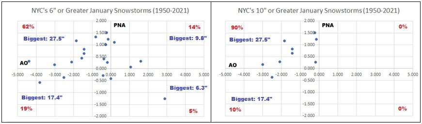
Scatter Diagrams for NYC’s 6”+ and 10”+ January snowstorms for the AO and PNA.
-
Morning thoughts… Today will be sunny and milder. High temperatures will likely reach upper 30s and lower 40s in most of the region. Likely high temperatures around the region include: New York City (Central Park): 38° Newark: 40° Philadelphia: 42° Normals: New York City: 30-Year: 39.3°; 15-Year: 40.2° Newark: 30-Year: 39.8°; 15-Year: 40.9° Philadelphia: 30-Year: 41.1°; 15-Year: 42.0° Another shot of cold air is likely this weekend. Afterward, a storm will likely bring snow changing to rain Sunday night or Monday.
-
After another very cold night, tomorrow will turn less harsh as the mercury again returns to the 30s in much of the region. However, another shot of Arctic air is likely late in the week. The subtropical jet could begin to become more active near mid-month. That could create additional opportunities for storminess. January commenced with an AO-/PNA- pattern. That typically favors somewhat cooler than normal readings in the East. For NYC, the January 1-10, 1991-2020 mean temperature for such cases was 33.5° (normal: 34.8°). This time around, the average will be warmer, but the transition toward colder weather has occurred. By mid-month, New York City's temperature anomaly will very likely be below normal. Based on the latest guidance, it appears that the colder pattern that is now in place could last 3-4 weeks until late in the month. The PNA is now positive and is likely to remain positive through at least January 20. A positive PNA is associated with more frequent snowfalls in the Middle Atlantic region. The ENSO Region 1+2 anomaly was -0.9°C and the Region 3.4 anomaly was -1.1°C for the week centered around January 5. For the past six weeks, the ENSO Region 1+2 anomaly has averaged -1.32°C and the ENSO Region 3.4 anomaly has averaged -1.05°C. La Niña conditions will likely persist through meteorological winter. The SOI was -5.04 today. The preliminary Arctic Oscillation (AO) was +0.773. On January 9 the MJO was in Phase 7 at an amplitude of 1.885 (RMM). The January 8-adjusted amplitude was 2.031 (RMM). Based on sensitivity analysis applied to the latest guidance, there is an implied 81% probability that New York City will have a colder than normal January (1991-2020 normal). January will likely finish with a mean temperature near 31.6° (2.1° below normal).
-
Despite brilliant sunshine, the noon temperature at Central Park was 16. The last time the temperature was in the teens at noon was February 1, 2019 when the mercury also stood at 16. The high temperature that day was 21.
-
Last night's snow squall:
-
Morning thoughts… Today will be sunny but very cold. High temperatures will likely reach upper teens and lower 20s in most of the region. Likely high temperatures around the region include: New York City (Central Park): 21° Newark: 23° Philadelphia: 25° Normals: New York City: 30-Year: 39.4°; 15-Year: 40.2° Newark: 30-Year: 39.9°; 15-Year: 41.0° Philadelphia: 30-Year: 41.2°; 15-Year: 42.1° After a cold start, tomorrow will turn milder. Another shot of very cold air will move into the region late this week.
-
Quick video from around 12:40 am:
-
It will be bitterly cold tomorrow. Temperatures will likely rise no higher than the upper teens and lower 20s as the core of the Arctic air mass moves through the region. Even Washington, DC's record-smashing 1,072 day streak without a temperature in the teens could come to an end tomorrow or Wednesday morning. Wednesday will be less harsh as the mercury again returns to the 30s in much of the region. The subtropical jet could begin to become more active near mid-month. That could create additional opportunities for storminess. January commenced with an AO-/PNA- pattern. That typically favors somewhat cooler than normal readings in the East. For NYC, the January 1-10, 1991-2020 mean temperature for such cases was 33.5° (normal: 34.8°). This time around, the average will be warmer, but the transition toward colder weather has occurred. By mid-month, New York City's temperature anomaly will very likely be below normal. Based on the latest guidance, it appears that the colder pattern that is now in place could last 3-4 weeks until late in the month. The PNA has just gone positive and is likely to remain positive through January 20. A positive PNA is associated with more frequent snowfalls in the Middle Atlantic region. The ENSO Region 1+2 anomaly was -0.9°C and the Region 3.4 anomaly was -1.1°C for the week centered around January 5. For the past six weeks, the ENSO Region 1+2 anomaly has averaged -1.32°C and the ENSO Region 3.4 anomaly has averaged -1.05°C. La Niña conditions will likely persist through meteorological winter. The SOI was -24.11 today. The preliminary Arctic Oscillation (AO) was -0.059. On January 8 the MJO was in Phase 7 at an amplitude of 2.032 (RMM). The January 7-adjusted amplitude was 2.047 (RMM). Based on sensitivity analysis applied to the latest guidance, there is an implied 75% probability that New York City will have a colder than normal January (1991-2020 normal). January will likely finish with a mean temperature near 31.8° (1.9° below normal).
-
Morning thoughts… In the wake of the Arctic front’s passage, temperatures are falling. It will be partly sunny, windy, and cold today. High temperatures will likely reach upper 20s and lower 30s in most of the region. Likely high temperatures around the region include: New York City (Central Park): 28° Newark: 31° Philadelphia: 32° Normals: New York City: 30-Year: 39.5°; 15-Year: 40.3° Newark: 30-Year: 39.9°; 15-Year: 41.1° Philadelphia: 30-Year: 41.3°; 15-Year: 42.2° Tomorrow will be the coldest day this winter so far. Temperatures will rise no higher than the upper teens and lower 20s.
-
Arctic air will move into the region starting late tonight or early tomorrow morning. Tomorrow will see the temperature remain nearly steady during the daytime before falling. Readings will likely top out in the upper 20s and perhaps lower 30s throughout much of the region. A bitterly cold day will follow on Tuesday. Temperatures will remain near or below 20° throughout the day as the core of the Arctic air mass moves through the region. Even Washington, DC's record-smashing 1,071 day streak without a temperature in the teens could come to an end. Wednesday will be less harsh as the mercury again returns to the 30s. The subtropical jet could begin to become more active near mid-month. That could create additional opportunities for storminess. January commenced with an AO-/PNA- pattern. That typically favors somewhat cooler than normal readings in the East. For NYC, the January 1-10, 1991-2020 mean temperature for such cases was 33.5° (normal: 34.8°). This time around, the average will be warmer, but the transition toward colder weather has occurred. By mid-month, New York City's temperature anomaly will likely be below normal. Based on the latest guidance, it appears that the colder pattern that is now in place could last 3-4 weeks. The ENSO Region 1+2 anomaly was -1.5°C and the Region 3.4 anomaly was -1.0°C for the week centered around December 29. For the past six weeks, the ENSO Region 1+2 anomaly has averaged -1.33°C and the ENSO Region 3.4 anomaly has averaged -0.98°C. La Niña conditions will likely persist through meteorological winter. The SOI was -27.74 today. That was the lowest value since June 20, 2020 when the SOI was -33.95. The preliminary Arctic Oscillation (AO) was -0.148. MJO information was not available. Based on sensitivity analysis applied to the latest guidance, there is an implied 68% probability that New York City will have a colder than normal January (1991-2020 normal). January will likely finish with a mean temperature near 32.0° (1.7° below normal).
-
Morning thoughts… It will be mostly cloudy and milder today. Some light rain is possible, with some freezing rain occurring north and west of New York City and Newark. High temperatures will likely reach upper 30s and lower 40s in most of the region. Likely high temperatures around the region include: New York City (Central Park): 40° Newark: 41° Philadelphia: 44° Normals: New York City: 30-Year: 39.5°; 15-Year: 40.5° Newark: 30-Year: 40.0°; 15-Year: 41.2° Philadelphia: 30-Year: 41.4°; 15-Year: 42.3° Arctic air will begin moving toward the region tomorrow. Tuesday will be the coldest day this winter so far.
-
Things are warmer now (1991-2020 base).
-
Some freezing rain is possible tomorrow before temperatures become briefly milder. An even stronger cold shot is likely early next week with temperatures remaining near or below 20° throughout the day on Tuesday. Even Washington, DC's record-smashing 1,070 day streak without a temperature in the teens could come to an end. The subtropical jet could begin to become more active near mid-month. That could create additional opportunities for storminess. January commenced with an AO-/PNA- pattern. That typically favors somewhat cooler than normal readings in the East. For NYC, the January 1-10, 1991-2020 mean temperature for such cases was 33.5° (normal: 34.8°). This time around, the average will be warmer, but the transition toward colder weather has occurred. By mid-month, New York City's temperature anomaly will likely be below normal. Based on the latest guidance, it appears that the colder pattern that is now in place could last 3-4 weeks. The ENSO Region 1+2 anomaly was -1.5°C and the Region 3.4 anomaly was -1.0°C for the week centered around December 29. For the past six weeks, the ENSO Region 1+2 anomaly has averaged -1.33°C and the ENSO Region 3.4 anomaly has averaged -0.98°C. La Niña conditions will likely persist through meteorological winter. The SOI was -22.65 today. The preliminary Arctic Oscillation (AO) was +0.768. MJO information was not available. Based on sensitivity analysis applied to the latest guidance, there is an implied 70% probability that New York City will have a colder than normal January (1991-2020 normal). January will likely finish with a mean temperature near 32.0° (1.7° below normal).
-
I’m sorry to read this. You have my fullest condolences.
-
Big snowstorm for Days 11-12.
-
Morning thoughts… It will be mostly sunny and cold today. High temperatures will likely reach mainly the lower 30s in most of the region. Likely high temperatures around the region include: New York City (Central Park): 30° Newark: 32° Philadelphia: 32° Normals: New York City: 30-Year: 39.6°; 15-Year: 40.6° Newark: 30-Year: 40.1°; 15-Year: 41.3° Philadelphia: 30-Year: 41.5°; 15-Year: 42.3° Some light rain and ice is possible tomorrow. An Arctic shot lies ahead for early next week.
-
This is the one: 115 NOUS41 KOKX 281641 PNSOKX NJZ002>006-011-NYZ067>081-CTZ005>012-282000- PUBLIC INFORMATION STATEMENT - SPOTTER REPORTS NATIONAL WEATHER SERVICE UPTON NY 1130 AM EST WED JAN 28 2004 THE FOLLOWING ARE UNOFFICIAL STORM TOTAL SNOWFALL ACCUMULATIONS... IN INCHES...FROM THE WINTER STORM THAT AFFECTED SOUTHEAST NEW YORK...NORTHEAST NEW JERSEY AND SOUTHERN CONNECTICUT. WE EXTEND OUR APPRECIATION TO HIGHWAY DEPARTMENTS...COOPERATIVE OBSERVERS... SKYWARN SPOTTERS AND OTHERS FOR THEIR REPORTS. THIS SUMMARY IS ALSO AVAILABLE ON THE WORLD WIDE WEB...VIA OUR HOME PAGE AT HTTP://WWW.ERH.NOAA.GOV/OKX (ALL LOWER CASE). STORM TIME/DATE COMMENTS LOCATION SNOWFALL OF (INCHES) MEASUREMENT CONNECTICUT ...FAIRFIELD... STAMFORD 11.0 0900 AM 1/28 COS COB 11.0 0900 AM 1/28 NEW CANAAN 10.5 1030 AM 1/28 DARIEN 10.0 0900 AM 1/28 NORWALK 9.6 0935 AM 1/28 SHELTON 7.0 1005 AM 1/28 DANBURY 6.8 0900 AM 1/28 WESTPORT 6.1 0620 AM 1/28 BRIDGEPORT 5.0 0630 AM 1/28 ...NEW HAVEN... WATERBURY 8.0 0900 AM 1/28 BEACON FALLS 7.8 0900 AM 1/28 NORTH BRANFORD 7.5 0930 AM 1/28 MERIDEN 6.5 0900 AM 1/28 NEW HAVEN 6.3 0900 AM 1/28 NAUGATUCK 6.0 0400 AM 1/28 MILFORD 6.0 0900 AM 1/28 ...MIDDLESEX... HADDAM 6.8 0900 AM 1/28 OLD SAYBROOK 6.8 0900 AM 1/28 ...NEW LONDON... JEWITT CITY 7.0 0600 AM 1/28 COLCHESTER 6.8 0900 AM 1/28 OLD SAYBROOK 6.8 0900 AM 1/28 GROTON 6.5 0900 AM 1/28 NORWICH 6.0 0650 AM 1/28 NEW JERSEY ...BERGEN... ELMWOOD PARK 11.0 0900 AM 1/28 RIDGEWOOD 10.5 0700 AM 1/28 FAIR LAWN 10.3 0630 AM 1/28 FORT LEE 9.5 0645 AM 1/28 CLOSTER 9.3 0700 AM 1/28 OAKLAND 9.0 0700 AM 1/28 SADDLE BROOK 9.0 0700 AM 1/28 MIDLAND PARK 9.0 0800 AM 1/28 RAMSEY 8.8 0700 AM 1/28 GARFIELD 8.4 0630 AM 1/28 WYCKOFF 8.3 0700 AM 1/28 RIVER VALE 6.8 0900 AM 1/28 ...ESSEX... SOUTH ORANGE 9.0 0905 AM 1/28 IRVINGTON 8.0 0905 AM 1/28 NEWARK INTL AIRPORT 7.0 1100 AM 1/28 WEST ORANGE 6.5 0800 AM 1/28 BLOOMFIELD 6.5 0700 AM 1/28 ...HUDSON... HARRISON 8.5 0800 AM 1/28 SECAUCUS 7.0 1045 AM 1/28 KEARNY 5.5 1030 AM 1/28 ...PASSAIC... BLOOMINGDALE 12.2 0700 AM 1/28 WAYNE 10.6 0930 AM 1/28 WANAQUE 10.5 0600 AM 1/28 LITTLE FALLS 9.0 0820 AM 1/28 GREENWOOD 8.0 0700 AM 1/28 ...UNION... UNION TOWNSHIP 8.7 0745 AM 1/28 ROSELLE PARK 8.3 0925 AM 1/28 CRANFORD 5.8 0730 AM 1/28 GARWOOD 5.5 0630 AM 1/28 NEW YORK ...BRONX... PARKCHESTER 10.4 0800 AM 1/28 ...KINGS... GRAVESEND 8.3 0840 AM 1/28 SHEEPSHEAD BAY 7.5 0830 AM 1/28 ...NASSAU... BELLMORE 11.5 0700 AM 1/28 SOUTH MERRICK 9.5 0755 AM 1/28 GREAT NECK 9.5 0930 AM 1/28 LEVITTOWN 9.0 0800 AM 1/28 NORTH MERRICK 8.5 0850 AM 1/28 OCEANSIDE 8.3 1000 AM 1/28 HICKSVILLE 7.7 0725 AM 1/28 FLORAL PARK 7.1 0820 AM 1/28 LONG BEACH 7.0 0930 AM 1/28 MERRICK 7.0 0930 AM 1/28 ROCKVILLE CENTER 7.0 1020 AM 1/28 LYNBROOK 6.5 1115 AM 1/28 ...NEW YORK... CENTRAL PARK 10.3 1030 AM 1/28 ...ORANGE... NEW WINDSOR 10.6 0800 AM 1/28 MONROE 10.3 0755 AM 1/28 GOSHEN 9.3 0745 AM 1/28 WALDEN 9.0 0800 AM 1/28 WARWICK 9.0 0730 AM 1/28 GREENWOOD LAKE 8.5 0700 AM 1/28 BLOOMING GROVE 8.3 1030 AM 1/28 MIDDLETOWN 7.8 0740 AM 1/28 ...PUTNUM... PATTERSON 8.0 0800 AM 1/28 CARMEL 7.0 0800 AM 1/28 ...QUEENS... FAR ROCKAWAY 10.5 0830 AM 1/28 LA GUARDIA AIRPORT 8.7 0700 AM 1/28 FRESH MEADOWS 8.0 0630 AM 1/28 RIDGEWOOD 6.5 0500 AM 1/28 JFK AIRPORT 6.2 0700 AM 1/28 ...RICHMOND... STATEN ISLAND 7.0 1200 AM 1/28 WESTERLEIGH 5.5 0855 AM 1/28 ...ROCKLAND... SUFFERN 9.0 0845 AM 1/28 SPARKILL 6.8 0700 AM 1/28 NEW CITY 6.0 0700 AM 1/28 ...SUFFOLK... DIX HILLS 14.6 0845 AM 1/28 SMITHTOWN 13.5 0900 AM 1/28 CENTERPORT 11.5 0730 AM 1/28 ISLIP 11.5 0830 AM 1/28 WEST BABYLON 11.3 0700 AM 1/28 SAINT JAMES 11.2 0830 AM 1/28 EAST NORTHPORT 11.2 1000 AM 1/28 WEST BABYLON 11.0 0910 AM 1/28 CENTEREACH 10.7 1030 AM 1/28 NORTH BABYLON 10.5 1000 AM 1/28 WEST ISLIP 10.1 0930 AM 1/28 LAKE RONKONKOMA 10.0 0945 AM 1/28 PORT JEFFERSON STATION 10.0 1000 AM 1/28 FARMINGDALE 9.5 0845 AM 1/28 SHOREHAM 9.5 0930 AM 1/28 SAYVILLE 9.0 0915 AM 1/28 NWS UPTON 8.1 0700 AM 1/28 RIVERHEAD 8.0 0945 AM 1/28 ROCKY POINT 7.5 0920 AM 1/28 MANORVILLE 7.5 0800 AM 1/28 EAST SETAUKET 6.4 0700 AM 1/28 EAST QUOGUE 6.0 0900 AM 1/28 BAITING HOLLOW 5.7 0800 AM 1/28 EAST HAMPTON 5.0 0800 AM 1/28 SAG HARBOR 4.5 0840 AM 1/28 SOUTHAMPTON 4.1 0830 AM 1/28 ...WESTCHESTER... HASTING-ON-HUDSON 10.0 0850 AM 1/28 THORNWOOD 10.0 0750 AM 1/28 WHITE PLAINS 9.5 0700 AM 1/28 YORKTOWN HEIGHTS 8.0 0800 AM 1/28 OSSINING 8.0 0820 AM 1/28 $$
-
@LibertyBell For reference, you can find archived NWS text products here: https://mesonet.agron.iastate.edu/wx/afos/list.phtml
-
No. Those are the Canadian ensembles.
-
Other than the January 2004 event, no.
-
929 NOUS41 KOKX 161742 CCA PNSOKX NJZ002>006-011-NYZ067>081-CTZ005>012-151800- PUBLIC INFORMATION STATEMENT...CORRECTED DATE OF ISSUANCE NATIONAL WEATHER SERVICE UPTON NY 355 PM EST THU JAN 15 2004 THIS WILL LIKELY BE THE FINAL UNOFFICIAL SNOWFALL ACCUMULATION STATEMENT FOR THE JAN 14TH - 15TH SNOW EVENT. THANKS TO ALL OF OUR SPOTTERS...COOPERATIVE OBSERVERS AND OTHERS WHO SENT SNOWFALL REPORTS TO THE NATIONAL WEATHER SERVICE. STORM TIME/DATE COMMENTS LOCATION SNOWFALL OF (INCHES) MEASUREMENT NEW YORK NEW YORK COUNTY CENTRAL PARK ZOO 5.7 FINAL-1000 AM EST BRYANT PARK 5.2 1000 AM EST BRONX COUNTY RIVERDALE 7.0 945 AM EST QUEENS COUNTY FAR ROCKAWAY 7.0 645 AM EST LAGUARDIA AIRPORT 6.8 1000 AM EST RICHMOND HILL 6.0 1000 AM EST JOHN F. KENNEDY AIRPORT 5.8 1000 AM EST KINGS COUNTY BROOKLYN 6.3 700 AM EST GRAVES END 5.7 805 AM EST RICHMOND COUNTY ELTINGVILLE 6.4 945 AM EST RICHMOND 6.0 1100 AM EST GRASMERE 5.8 1030 AM EST NASSAU COUNTY FARMINGDALE 7.0 1015 AM EST WEST HEMPSTEAD 7.0 930 AM EST OCEANSIDE 6.8 1005 AM EST NORTH MERRICK 6.8 900 AM EST LYNBROOK 5.5 1125 AM EST LEVITTOWN 4.5 645 AM EST SUFFOLK COUNTY SELDEN 8.1 1130 AM EST PORT JEFFERSON STATION 8.0 930 AM EST CENTEREACH 7.2 940 AM EST DIX HILLS 7.1 1030 AM EST CENTERPORT 7.0 700 AM EST EAST NORTHPORT 7.0 840 AM EST BOHEMIA 7.0 1000 AM EST NWS UPTON (BNL) 6.5 1000 AM EST SAG HARBOR 6.5 930 AM EST LAKE RONKONKOMA 6.5 945 AM EST EASTHAMPTON AIRPORT 6.5 1030 AM EST BAITING HOLLOW 6.1 1130 AM EST ROCKY POINT 6.0 1000 AM EST MT. SINAI 6.0 730 AM EST WEST ISLIP 6.0 930 AM EST COPIAGE 5.9 900 AM EST SMITHTOWN 5.7 700 AM EST ST. JAMES 5.7 730 AM EST HAUPPAUGE 5.5 730 AM EST ISLIP AIRPORT 5.0 1020 AM EST ISLIP HAMLET 5.0 700 AM EST MANORVILLE 5.0 1030 AM EST ISLIP 4.5 1155 AM EST MATTITUCK 4.4 1145 AM EST SOUTHOLD 4.3 1030 AM EST SOUTHAMPTON 4.2 840 AM EST PECONIC 4.0 745 AM EST WESTCHESTER COUNTY YONKERS 6.5 1030 AM EST WEST HARRISON 6.4 1100 AM EST BRONXVILLE 6.0 700 AM EST THORNWOOD 5.8 750 AM EST POUND RIDGE 5.5 700 AM EST WESTCHESTER CO. AIRPORT 5.0 1000 AM EST WHITE PLAINS 4.7 100 PM EST MAMARONECK 4.0 1120 AM EST ROCKLAND COUNTY ORANGEBURG 5.7 725 AM EST ORANGE COUNTY CHESTER 7.4 700 AM EST TUXEDO PARK 7.0 1200 PM EST PORT JERVIS 7.0 700 AM EST WARWICK 7.0 900 AM EST MIDDLETOWN 6.0 630 AM EST CIRCLEVILLE 5.8 900 AM EST MONTGOMERY 5.0 620 AM EST CORNWALL-ON-THE-HUDSON 5.0 800 AM EST NEW WINDSOR 5.0 745 AM EST WALDEN 3.0 600 AM EST NEW JERSEY BERGEN COUNTY LODI 7.3 800 AM EST NORTH ARLINGTON 7.2 1135 AM EST TETERBORO AIRPORT 5.5 1000 AM EST RIVER VALE 5.3 830 AM EST FAIR LAWN 5.2 930 AM EST BERGENFIELD 6.0 1230 PM EST SADDLE BROOK 4.5 830 AM EST ESSEX COUNTY NEWARK AIRPORT 7.4 1000 AM EST WEST CALDWELL 6.4 915 AM EST WEST ORANGE 5.7 900 AM EST CEDAR GROVE 5.6 1200 PM EST PASSAIC COUNTY BLOOMINGDALE 6.8 930 AM EST LITTLE FALLS 5.5 900 AM EST HUDSON COUNTY HARRISON 7.1 1215 PM EST KEARNY 5.0 1145 AM EST UNION COUNTY CLARK 7.5 1200 PM EST UNION TWP 7.5 1200 PM EST ELIZABETH 6.8 930 AM EST CRANFORD 6.8 1100 AM EST GARWOOD 5.0 700 AM EST CONNECTICUT FAIRFIELD COUNTY COS COB 6.0 1000 AM EST DARIEN 5.3 700 AM EST STAMFORD 5.0 1000 AM EST RIVERSIDE 5.0 730 AM EST NORWALK 4.6 1130 AM EST NEW CANAAN 4.5 700 AM EST DANBURY 4.3 1200 PM EST BRIDGEPORT 3.5 900 AM EST NEW HAVEN COUNTY MILFORD 4.0 700 AM EST NORTH BRANFORD 3.5 1000 AM EST NEW HAVEN 3.3 700 AM EST MADISON 3.1 700 AM EST OXFORD 2.8 1200 PM EST BEACON FALLS 2.3 700 AM EST WATERBURY 2.0 700 AM EST MERIDEN 2.0 700 AM EST MIDDLESEX COUNTY HADDAM 3.0 700 AM EST EAST HAMPTON 2.5 915 AM EST OLD SAYBROOK 2.5 700 AM EST NEW LONDON COUNTY GROTON 2.5 700 AM EST COLCHESTER 2.0 700 AM EST NORWICH 1.3 700 AM EST $$ SR
-
000 NOUS41 KOKX 072106 PNSOKX CTZ005>012-NJZ002-004-006-103>108-NYZ067>075-078>081-176>179-080906- Public Information Statement National Weather Service New York NY 406 PM EST Fri Jan 7 2022 ...SNOWFALL REPORTS... Location Amount Time/Date Provider ...Connecticut... ...Fairfield County... New Canaan 8.6 in 0700 AM 01/07 Trained Spotter 2 NNE Stamford 8.6 in 1045 AM 01/07 Trained Spotter Stratford 8.5 in 0800 AM 01/07 Public 2 NNE Norwalk 8.5 in 0937 AM 01/07 Public Bridgeport 8.4 in 0100 PM 01/07 Official NWS Obs 2 NE Norwalk 8.2 in 0830 AM 01/07 Trained Spotter Newtown 8.1 in 0730 AM 01/07 Public Weston 8.1 in 1000 AM 01/07 Trained Spotter Fairfield 8.0 in 0700 AM 01/07 Public Greenwich 8.0 in 0830 AM 01/07 Public 2 ESE New Canaan 7.9 in 0830 AM 01/07 Public Danbury 7.6 in 1000 AM 01/07 Trained Spotter 1 NNE Redding 7.5 in 0910 AM 01/07 Cocorahs 3 E Easton 7.5 in 0926 AM 01/07 Public Stratford 7.0 in 0645 AM 01/07 Public Shelton 7.0 in 0820 AM 01/07 Public Darien 6.5 in 1000 AM 01/07 Trained Spotter Stamford 6.0 in 1000 AM 01/07 Public Ridgefield 5.0 in 0837 AM 01/07 Public New Fairfield 4.5 in 0931 AM 01/07 Trained Spotter ...Middlesex County... Higganum 11.0 in 0643 AM 01/07 Public 1 NNE Middletown 10.8 in 0830 AM 01/07 Broadcast Media Cromwell 8.8 in 0630 AM 01/07 Public 1 E Westbrook 7.0 in 1200 PM 01/07 Trained Spotter ...New Haven County... 1 NNW Waterbury 12.0 in 0800 AM 01/07 Public Madison 10.9 in 0748 AM 01/07 Trained Spotter Branford 10.5 in 0955 AM 01/07 Public Guilford 10.5 in 0957 AM 01/07 Trained Spotter Hamden 9.9 in 1000 AM 01/07 Trained Spotter 3 E Ansonia 9.5 in 0700 AM 01/07 Public North Haven 9.5 in 0925 AM 01/07 Trained Spotter 1 N Cheshire 9.0 in 0700 AM 01/07 Public Milford 9.0 in 0800 AM 01/07 Trained Spotter New Haven 9.0 in 0900 AM 01/07 Broadcast Media 1 SE West Haven 9.0 in 0930 AM 01/07 Trained Spotter 1 SW Branford 8.9 in 1000 AM 01/07 Trained Spotter Southbury 7.5 in 0940 AM 01/07 Public ...New London County... 3 WSW Franklin 7.0 in 0626 AM 01/07 Public Colchester 7.0 in 0630 AM 01/07 Public 2 SSE Ledyard Center 5.3 in 1100 AM 01/07 Trained Spotter Ledyard Center 5.1 in 1015 AM 01/07 Public ...New Jersey... ...Bergen County... Closter 7.3 in 0820 AM 01/07 Public 1 NNW Lyndhurst 6.0 in 0830 AM 01/07 Public 1 W Fair Lawn 5.9 in 0900 AM 01/07 Cocorahs East Rutherford 5.6 in 0853 AM 01/07 Trained Spotter Fair Lawn 5.4 in 0700 AM 01/07 Public 1 WSW Washington Townshi 4.9 in 0930 AM 01/07 Trained Spotter Westwood 4.8 in 1014 AM 01/07 Trained Spotter Ridgewood 4.7 in 0758 AM 01/07 Trained Spotter 1 N River Vale 4.5 in 0140 PM 01/07 Trained Spotter 1 NE Franklin Lakes 4.3 in 0800 AM 01/07 Trained Spotter Park Ridge 4.1 in 1100 AM 01/07 Public Mahwah 4.0 in 0700 AM 01/07 Public 2 NW Upper Saddle River 4.0 in 0945 AM 01/07 Public 2 ENE Park Ridge 3.9 in 0915 AM 01/07 Trained Spotter 1 NNE Rutherford 3.5 in 1145 AM 01/07 Public ...Essex County... West Orange 6.3 in 0809 AM 01/07 Public North Caldwell 6.0 in 0800 AM 01/07 Trained Spotter 1 SSW West Caldwell 6.0 in 1030 AM 01/07 Public 1 NNE Livingston 5.0 in 0920 AM 01/07 Public Essex Fells 5.0 in 1020 AM 01/07 Public 1 N West Orange 5.0 in 1040 AM 01/07 Public ...Hudson County... Hoboken 6.8 in 1240 PM 01/07 Public Harrison 6.0 in 0800 AM 01/07 COOP 1 ENE Jersey City 6.0 in 0830 AM 01/07 Public Harrison 5.7 in 0715 AM 01/07 Trained Spotter Kearny 5.5 in 0900 AM 01/07 Cocorahs ...Passaic County... 1 SE Wayne 4.3 in 0840 AM 01/07 Trained Spotter ...Union County... Union 6.0 in 0730 AM 01/07 Public Plainfield 6.0 in 0810 AM 01/07 Trained Spotter Elizabeth 5.6 in 0800 AM 01/07 Trained Spotter Newark Airport 5.2 in 0100 PM 01/07 Official NWS Obs Cranford 5.0 in 0733 AM 01/07 Public 1 ESE Roselle Park 5.0 in 1030 AM 01/07 Trained Spotter Westfield 4.9 in 0800 AM 01/07 Public Plainfield 4.7 in 0800 AM 01/07 Trained Spotter ...New York... ...Bronx County... East Tremont 8.0 in 0801 AM 01/07 Public Parkchester 7.4 in 1000 AM 01/07 Trained Spotter 1 W East Tremont 7.1 in 0720 AM 01/07 CO-OP Observer 2 S Co-Op City 6.7 in 0902 AM 01/07 Broadcast Media ...Kings County... 1 SE Greenpoint 7.1 in 0900 AM 01/07 Public 2 E Coney Island 6.5 in 0800 AM 01/07 Trained Spotter 1 SSW Flatbush 6.4 in 0900 AM 01/07 Broadcast Media 3 SSE Flatbush 6.0 in 0830 AM 01/07 Public Greenpoint 6.0 in 0900 AM 01/07 Public 1 NNE Bay Ridge 6.0 in 1200 PM 01/07 Emergency Mngr ...Nassau County... Glen Cove 9.3 in 0910 AM 01/07 Public 1 N Syosset 8.9 in 0915 AM 01/07 Trained Spotter 1 SSE Mill Neck 8.8 in 1020 AM 01/07 Public Syosset 8.3 in 0700 AM 01/07 Trained Spotter Elmont 8.2 in 1018 AM 01/07 Public East Williston 8.2 in 1020 AM 01/07 Public Levittown 8.0 in 0830 AM 01/07 Public Plainview 8.0 in 0939 AM 01/07 Public Merrick 7.7 in 0911 AM 01/07 Trained Spotter Plainview 7.6 in 0952 AM 01/07 Public Oyster Bay 7.5 in 0757 AM 01/07 Public 2 ENE Bethpage 7.5 in 0800 AM 01/07 Public Jericho 7.1 in 0651 AM 01/07 Public Massapequa 7.0 in 0730 AM 01/07 Public East Meadow 7.0 in 0830 AM 01/07 NWS Employee 1 NNE Massapequa 6.7 in 0915 AM 01/07 Trained Spotter Manhasset Hills 6.7 in 1100 AM 01/07 Trained Spotter Seaford 6.5 in 0623 AM 01/07 Public 1 SSW East Rockaway 6.5 in 0700 AM 01/07 Trained Spotter Baldwin Harbor 6.3 in 0800 AM 01/07 Trained Spotter New Hyde Park 6.2 in 1145 AM 01/07 Trained Spotter West Hempstead 5.5 in 0600 AM 01/07 Trained Spotter ...New York County... Midtown Manhattan 6.2 in 0700 AM 01/07 Public Central Park 5.8 in 0100 PM 01/07 Official NWS Obs 2 SSE Greenwich Village 5.5 in 0649 AM 01/07 Broadcast Media ...Orange County... 1 WNW Monroe 3.5 in 0745 AM 01/07 Trained Spotter 2 SW Greenwood Lake 3.5 in 1000 AM 01/07 Public New Windsor 2.9 in 0930 AM 01/07 Public 3 WNW Warwick 2.5 in 1130 AM 01/07 Trained Spotter 5 SSW Otisville 2.1 in 0815 AM 01/07 Trained Spotter ...Putnam County... Putnam Valley 3.0 in 1000 AM 01/07 Broadcast Media ...Queens County... NYC/La Guardia 9.7 in 0100 PM 01/07 Official NWS Obs 1 SW Russell Gardens 7.9 in 1030 AM 01/07 Trained Spotter 1 S Lake Success 7.9 in 1255 PM 01/07 Amateur Radio 1 SSW Bayside 7.7 in 0930 AM 01/07 Trained Spotter 1 SE Elmhurst 7.5 in 0815 AM 01/07 Trained Spotter 1 SSW Bayside 7.3 in 0944 AM 01/07 Public Howard Beach 7.0 in 0700 AM 01/07 Trained Spotter 1 S Astoria 7.0 in 1000 AM 01/07 Public Jackson Heights 6.8 in 0800 AM 01/07 Trained Spotter 1 NW Elmhurst 6.5 in 0700 AM 01/07 Trained Spotter NYC/JFK 6.2 in 0100 PM 01/07 Official NWS Obs Elmhurst 6.0 in 0627 AM 01/07 Public Howard Beach 5.8 in 0915 AM 01/07 Broadcast Media 2 N Ozone Park 5.5 in 0630 AM 01/07 Public 1 SE Elmhurst 5.5 in 0820 AM 01/07 Trained Spotter ...Richmond County... 1 W Huguenot 5.3 in 0825 AM 01/07 Trained Spotter Westerleigh 4.3 in 0830 AM 01/07 Public ...Rockland County... Spring Valley 4.0 in 1215 PM 01/07 New Hempstead 3.9 in 0800 AM 01/07 Public Stony Point 3.3 in 0800 AM 01/07 Trained Spotter Nyack 3.0 in 0945 AM 01/07 Public ...Suffolk County... Setauket-East Seta 8.7 in 0900 AM 01/07 Public 1 ESE Huntington Station 8.6 in 0800 AM 01/07 Trained Spotter 1 WNW Stony Brook 8.6 in 0930 AM 01/07 NWS Employee 1 NE Dix Hills 8.6 in 0950 AM 01/07 Public 1 S Centereach 8.0 in 0900 AM 01/07 NWS Employee Commack 8.0 in 0945 AM 01/07 Broadcast Media 1 NE Lake Ronkonkoma 8.0 in 1000 AM 01/07 NWS Employee Saint James 8.0 in 1025 AM 01/07 Trained Spotter 1 WNW Babylon 7.9 in 1039 AM 01/07 Trained Spotter 1 ENE East Northport 7.8 in 0800 AM 01/07 Trained Spotter Miller Place 7.8 in 1000 AM 01/07 Public 2 S Deer Park 7.6 in 0930 AM 01/07 Public 1 SSW Miller Place 7.5 in 0900 AM 01/07 Public 1 SSE Sayville 7.3 in 0845 AM 01/07 NWS Employee Smithtown 7.2 in 0951 AM 01/07 Public Central Islip 7.1 in 0810 AM 01/07 Public Shirley 7.0 in 0735 AM 01/07 Public 1 S Bayport 7.0 in 0800 AM 01/07 NWS Employee Islip 7.0 in 1200 PM 01/07 Trained Spotter Bay Shore 6.8 in 0952 AM 01/07 NWS Employee Calverton 6.6 in 1045 AM 01/07 Trained Spotter Islip Airport 6.6 in 0100 PM 01/07 Official NWS Obs East Northport 6.5 in 0650 AM 01/07 Public 1 SW Amityville 6.5 in 1015 AM 01/07 Public North Patchogue 6.5 in 1018 AM 01/07 North Patchogue 6.5 in 1018 AM 01/07 Public Upton 6.4 in 1250 PM 01/07 Official NWS Obs Manorville 6.2 in 0715 AM 01/07 Public East Hampton 6.1 in 1000 AM 01/07 Public Babylon 6.0 in 0756 AM 01/07 Public 1 S North Bellport 6.0 in 0800 AM 01/07 Trained Spotter Mattituck 6.0 in 1030 AM 01/07 Trained Spotter Orient 6.0 in 1213 PM 01/07 Trained Spotter 1 W Upton 5.7 in 0700 AM 01/07 Official NWS Obs 2 NW Peconic River 5.7 in 0833 AM 01/07 NWS Employee Bellport 5.1 in 0720 AM 01/07 Public Babylon 5.0 in 0810 AM 01/07 Public Lake Ronkonkoma 5.0 in 1018 AM 01/07 Trained Spotter ...Westchester County... Port Chester 7.8 in 0725 AM 01/07 Public 1 E Pelham Manor 7.7 in 0700 AM 01/07 Public Larchmont 7.5 in 1000 AM 01/07 Public 1 NW New Rochelle 7.3 in 0954 AM 01/07 Public White Plains 7.0 in 0812 AM 01/07 Trained Spotter 2 N Mamaroneck 7.0 in 1100 AM 01/07 Public Yonkers 6.8 in 1015 AM 01/07 Trained Spotter Hastings-on-Hudson 6.5 in 0834 AM 01/07 Public Hartsdale 6.3 in 0930 AM 01/07 Trained Spotter Armonk 6.3 in 0932 AM 01/07 Public 1 NNE Hastings-on-Hudson 6.0 in 1240 PM 01/07 Public 1 SE Croton-on-Hudson 4.8 in 0940 AM 01/07 Trained Spotter 2 E Ossining 4.5 in 1100 AM 01/07 Public Montrose 3.8 in 0930 AM 01/07 Trained Spotter ...Maritime Stations... Lido Beach 7.5 in 0815 AM 01/07 Trained Spotter &&

