donsutherland1
-
Posts
23,768 -
Joined
Content Type
Profiles
Blogs
Forums
American Weather
Media Demo
Store
Gallery
Everything posted by donsutherland1
-
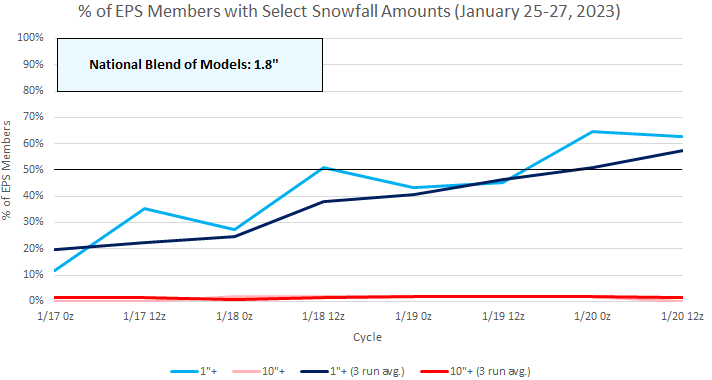
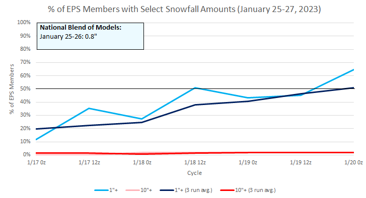
Today is the 317th consecutive day without measurable snowfall in New York City (4th longest streak). However, there remains ensemble support for measurable snowfall during the January 25-27 period. The 1/20 20z National Blend of Models has now increased snowfall to 1.8" during that time.
-
No one can reliably make 6 week weather predictions here or elsewhere. Beyond 2 weeks, even the best ensemble systems have limited skill. These are important points that should be kept in mind at all times. Yet, especially on some social media sites, long-range maps—even operational ones—are posted, frequently with accompanying claims, as if the events are essentially certain to unfold. Often the highlighted maps are the most extreme ones and they are deployed in a demonstration of confirmation bias. When the events don’t occur as forecast, one sees timelines adjusted e.g., the cold would be coming in early January, then mid-January, then late January and so one. Then, when a cold shot ultimately arrives, even if fairly unimpressive, forecasting “victory” is proclaimed. Instead, there was no real skill involved. No pattern lasts beyond a finite but irregular period. Thus, if one keeps claiming the “wolf” is coming, it will eventually show up. When it does, does this mean that there was forecasting skill? Of course, the same constraints on predictive skill apply in many other areas (financial market forecasts are rife with similar bold claims and lack of skill). The reality is that time comes with uncertainty. Longer forecasts can never be perfect.
-
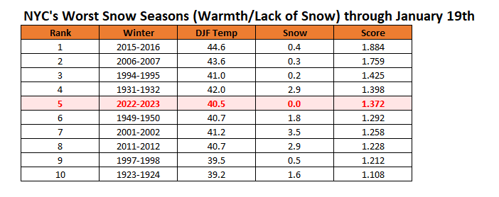
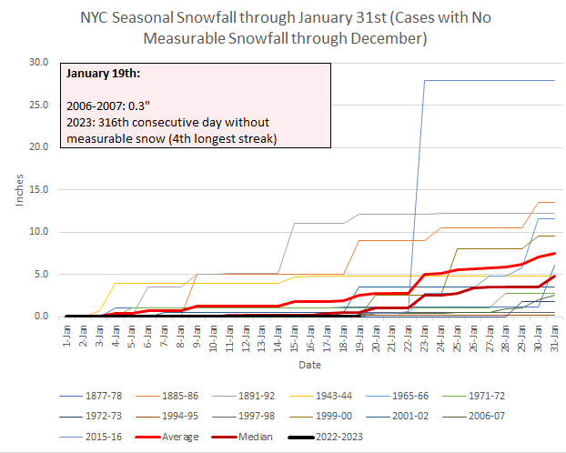
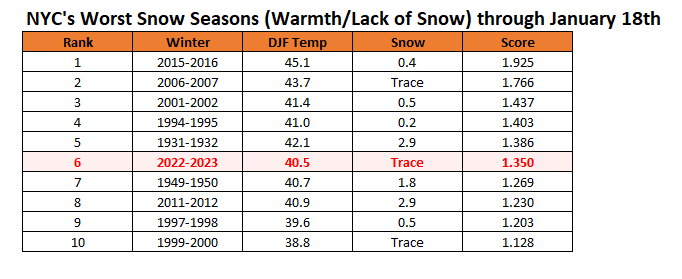
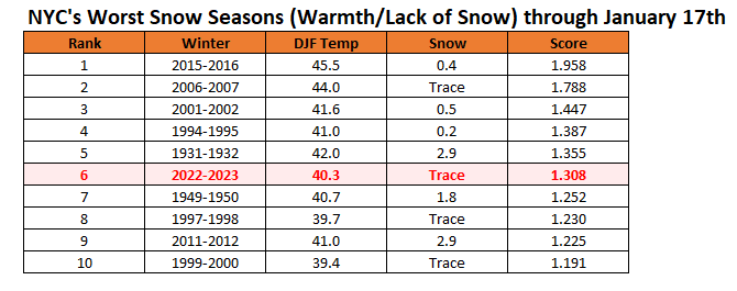
Snow season futility rankings through January 19th:
-
Unlike with recent storms going back to December, ensemble support has been increasing inside a week for potential measurable snow in New York City for January 25-27 (focus is on January 25-26). A big snowfall remains highly unlikely.
-
Morning thoughts… It will sunny and mild. High temperatures will reach the upper 40s in most areas. Likely high temperatures around the region include: New York City (Central Park): 48° Newark: 50° Philadelphia: 49° Temperatures will average above normal through the weekend. Normals: New York City: 30-Year: 39.1°; 15-Year: 39.7° Newark: 30-Year: 39.6°; 15-Year: 40.4° Philadelphia: 30-Year: 40.9°; 15-Year: 41.5°
-
Thunderstorm in Larchmont.

-
A reminder about the EPS weeklies. Beyond two weeks, skill disappears. So, temperature or 500 mb patterns shown for weeks 3-6 could be dramatically different from the actual outcomes. So, right now February could start cool but not severely cold. Moderation will then follow. Afterward, it’s uncertain how things will evolve.
-
Euro weekly guidance. The coolest week out of the next four:
-
Rain will end tonight or early tomorrow. A general 0.50"-1.00" remains likely in the region. Readings will remain above normal through at least the weekend. The lengthening measurable snow drought will persist in New York City and Philadelphia through at least the weekend. The next period of interest could be January 22-24. Ensemble support for measurable snow has fallen. The National Blend of Models shows no accumulations for New York City. A second storm could also impact the region a few days later. A cooler pattern will likely develop during the last 5-7 days of January. The duration of this cooler period remains uncertain. Should ridging develop in the East, a warming trend could develop during in early February following a cool start to the month. The ENSO Region 1+2 anomaly was -0.3°C and the Region 3.4 anomaly was -0.2°C for the week centered around January 11. For the past six weeks, the ENSO Region 1+2 anomaly has averaged -0.37°C and the ENSO Region 3.4 anomaly has averaged -0.82°C. La Niña conditions could fade to neutral conditions during late winter or early spring. The SOI was +6.36 today. The preliminary Arctic Oscillation (AO) was -2.221 today. On January 17 the MJO was in Phase 1 at an amplitude of 0.561 (RMM). The January 16-adjusted amplitude was 0.616 (RMM). Based on sensitivity analysis applied to the latest guidance, there is an implied near 100% probability that New York City will have a warmer than normal January (1991-2020 normal). January will likely finish with a mean temperature near 40.9° (7.2° above normal).
-
-
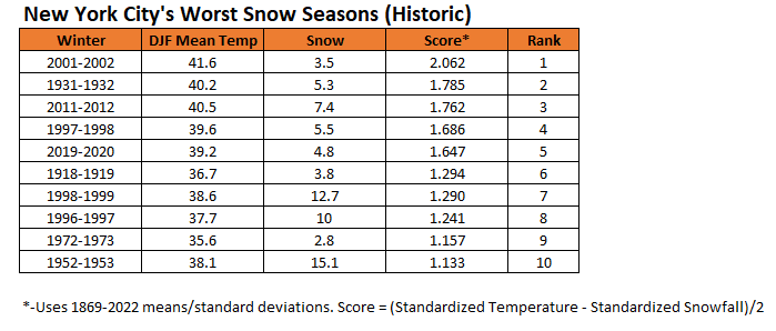
Winter 2001-2002 currently ranks 1st in terms of futility (warmth and lack of snow) for an entire snow season.
-
It very well could. Our best chance might be the January 25-27 system, but it is not a slam dunk. Things could well correct warmer than currently shown.
-
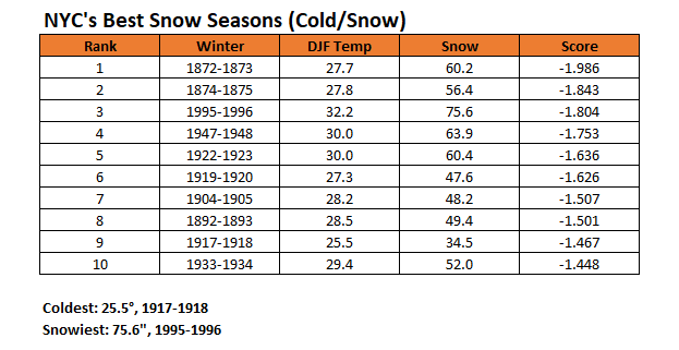
Overall, winter 1993-1994 wound up ranking 17th in terms of cold and snow. Without the relatively warm December, it would have ranked in the top 10. Winter 2010-11 ranked 14th. The cold is what has been absent from recent winters. 1995-1996 was the warmest of among the top 10 winters. That's why it ranked third on the combined scale (cold and snow are weighted equally).
-
2019-2020 had Central Park's 4th lowest snowfall. That there was the snowfall in May (no accumulation in the City) may have skewed perceptions about the duration of the period where there had been no measurable snowfall. Least snowy winters: 1972-1973: 2.8" 2001-2002: 3.5" 1918-1919: 3.8" 2019-2020: 4.8" 1900-1901: 5.1"
-
Occasional Thoughts on Climate Change
donsutherland1 replied to donsutherland1's topic in Climate Change
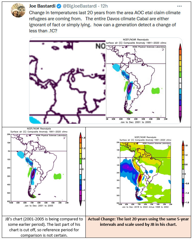
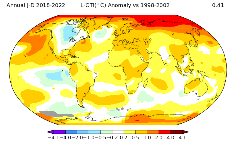
Today, Joe Bastardi made a claim that parts of South America have been cooling during the past 20 years. He included a map that references 2001-2005 as the most recent 20-year period while cutting off the date against which it is compared (the political components are ignored). The claim about temperatures is so flawed that I address it below. The actual data shows that warming has been strongest where the tweeted map alleges the strongest cooling has occurred based on comparing 2001-2005 to some earlier period (not the "last 20 years"). When one goes to the GISS maps for the 20-year comparison, one finds warming across much of South America, as well. In sum, the actual data demonstrate that the tweeted claim is incorrect.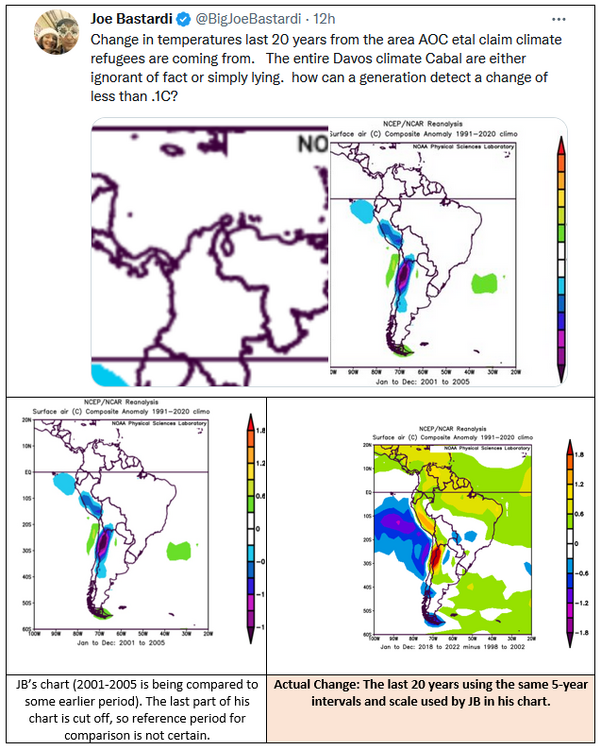
-
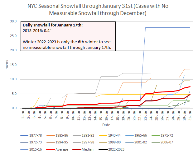
On this date in 2007, 0.3" of snow fell. That was Winter 2006-2007's first measurable snowfall of the season. Winter 2022-2023 will become only the fourth winter in New York City (Central Park) to have no measurable snowfall through January 19th. Records go back to January 1869. There is low ensemble support for some measurable snow during January 23rd. The National Blend of Models shows no snowfall. Most of the operational guidance has moved away from any accumulations in Central Park. Another system could bring at least the possibility of measurable snow during January 25-27. Ensemble support is moderate. Such support has also been higher than it was for the preceding event. The operational guidance generally shows little or no snowfall. In sum, New York City's measurable snow drought will very likely continue into at least early next week. There is some possibility that it could extend through the remainder of the month.
-
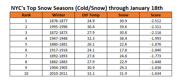
NYC's winter futility rankings through January 18th:
-
Morning thoughts… It will mostly cloudy, rainy, and mild. High temperatures will reach the middle and perhaps upper 40s in most areas. Likely high temperatures around the region include: New York City (Central Park): 45° Newark: 46° Philadelphia: 47° Temperatures will average above normal during the week. Normals: New York City: 30-Year: 39.1°; 15-Year: 39.8° Newark: 30-Year: 39.6°; 15-Year: 40.4° Philadelphia: 30-Year: 40.9°; 15-Year: 41.5°
-
Rain will arrive tomorrow and continue into Friday. A general 0.50"-1.00" appears likely in the region. Readings will remain above normal. The lengthening measurable snow drought will persist in New York City and Philadelphia through at least the weekend. The next period of interest could be January 22-24. Ensemble support for measurable snow had recently increased to moderate levels. However, the National Blend of Models shows no accumulations for New York City. A second storm could also impact the region a few days later. A cooler pattern will likely develop during the last 5-7 days of January. The duration of this cooler period remains uncertain. Should ridging develop in the East, a warming trend could develop during in early February following a cool start to the month. The ENSO Region 1+2 anomaly was -0.3°C and the Region 3.4 anomaly was -0.2°C for the week centered around January 11. For the past six weeks, the ENSO Region 1+2 anomaly has averaged -0.37°C and the ENSO Region 3.4 anomaly has averaged -0.82°C. La Niña conditions could fade to neutral conditions during late winter or early spring. The SOI was +6.36 today. The preliminary Arctic Oscillation (AO) was -2.695 today. On January 16 the MJO was in Phase 8 at an amplitude of 0.594 (RMM). The January 15-adjusted amplitude was 0.467 (RMM). Based on sensitivity analysis applied to the latest guidance, there is an implied near 100% probability that New York City will have a warmer than normal January (1991-2020 normal). January will likely finish with a mean temperature near 40.8° (7.1° above normal).
-
New York City's latest winter season futility rankings:
-
Morning thoughts… It will become partly sunny and mild. High temperatures will reach the upper 40s and lower 50s in most areas. Likely high temperatures around the region include: New York City (Central Park): 51° Newark: 53° Philadelphia: 53° Temperatures will average above normal during the week. Normals: New York City: 30-Year: 39.1°; 15-Year: 39.8° Newark: 30-Year: 39.6°; 15-Year: 40.5° Philadelphia: 30-Year: 40.9°; 15-Year: 41.6°
-
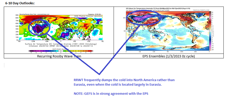
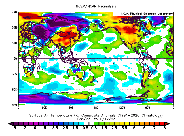
For purposes of illustration, here's how the January 8-13, 2023 period turned out. As noted regarding the RRWT's bias, it dumped the cold into North America when, in fact, the cold wound up in Eurasia as suggested by the EPS ensembles.
-
Tomorrow will be partly sunny and unseasonably mild. Temperatures will likely reach or exceed 50° in much of the region. After another mild day on Thursday, a storm will bring rain Thursday night into Friday. Readings will remain above normal. The lengthening measurable snow drought will persist in New York City and Philadelphia for at least several more days. The next period of interest could be January 22-24. Ensemble support for measurable snow had recently increased to moderate levels. However, the National Blend of Models shows no accumulations for New York City. A second storm could also impact the region a few days later. A cooler pattern will likely develop during the last 5-7 days of January. The duration of this cooler period remains uncertain. Should ridging develop in the East, a warming trend could develop during in early February following a cool start to the month. The ENSO Region 1+2 anomaly was -0.3°C and the Region 3.4 anomaly was -0.2°C for the week centered around January 11. For the past six weeks, the ENSO Region 1+2 anomaly has averaged -0.37°C and the ENSO Region 3.4 anomaly has averaged -0.82°C. La Niña conditions could fade to neutral conditions during late winter or early spring. The SOI was +1.65 today. The preliminary Arctic Oscillation (AO) was -1.878 today. On January 15 the MJO was in Phase 7 at an amplitude of 0.467 (RMM). The January 14-adjusted amplitude was 0.711 (RMM). Based on sensitivity analysis applied to the latest guidance, there is an implied near 100% probability that New York City will have a warmer than normal January (1991-2020 normal). January will likely finish with a mean temperature near 40.8° (7.1° above normal).
-