donsutherland1
-
Posts
23,765 -
Joined
Content Type
Profiles
Blogs
Forums
American Weather
Media Demo
Store
Gallery
Everything posted by donsutherland1
-
A brief shot of much cooler air will move through the region tomorrow and Wednesday. Tomorrow will likely see the temperature stay in the 50s in New York City and struggle to reach the lower 60s in Philadelphia. Noticeably warmer air will then return after midweek. The temperature could reach the upper 70s and perhaps lower 80s on Friday. A more sustained cool period could develop during or just after the next weekend and continue into the opening days of May. April 2023 remains on a trajectory that will likely rank it among the 10 warmest Aprils on record in the northern Middle Atlantic region. A cool end to the month won't be sufficient to avoid top 10 warmth. The most recent April case to rank among the 10 warmest was: Boston: 51.7°, 2019 (5th warmest) Bridgeport: 54.0°, 2017 (1st warmest) Islip: 51.9°, 2019 (6th warmest) New Haven: 50.8°, 2022 (6th warmest) New York City-Central Park: 57.2°, 2017 (2nd warmest) New York City-JFK Airport: 55.1°, 2017 (2nd warmest) New York City-LaGuardia Airport: 57.6°, 2017 (2nd warmest) Newark: 57.2°, 2017 (4th warmest) Philadelphia: 59.0°, 2019 (3rd warmest) Poughkeepsie: 53.0°, 2017 (3rd warmest) White Plains: 53.9°, 2017 (2nd warmest) The ENSO Region 1+2 anomaly was +2.7°C and the Region 3.4 anomaly was 0.0°C for the week centered around April 5. For the past six weeks, the ENSO Region 1+2 anomaly has averaged +1.77°C and the ENSO Region 3.4 anomaly has averaged -0.03°C. Neutral ENSO conditions will likely prevail through at least mid-spring. El Niño conditions will likely develop during the summer. The SOI was -7.43 today. The preliminary Arctic Oscillation (AO) was -0.955 today. On April 15 the MJO was in Phase 7 at an amplitude of 1.750 (RMM). The April 14-adjusted amplitude was 1.661 (RMM). Based on sensitivity analysis applied to the latest guidance, there is an implied 97% probability that New York City will have a warmer than normal April (1991-2020 normal). April will likely finish with a mean temperature near 57.8° (4.1° above normal). That would rank as the second warmest April on record.
-
Unfortunately, I am not aware of such data.
-
Following four consecutive 80° or above days, Madison is about to see 2"-5" of snow overnight into tomorrow. Should measurable snowfall be recorded today, that would be the first time Madison has ever seen measurable snowfall one day after an 80° or above reading. Madison has had 3 measurable snowfalls two days after such a temperature: April 2, 1978: 0.5", October 23, 1979: 0.2", and April 9, 1991: 0.5". No such wintry weather is likely anytime soon in the northern Mid-Atlantic region. However, it will turn briefly cooler this week. Tomorrow will be another mild day, but a brief shot of much cooler air will follow. Tuesday may see the temperature stay in the 50s in New York City and struggle to reach the lower 60s in Philadelphia. Milder air will then follow, but a more sustained cool period could develop next weekend. April 2023 remains on a trajectory that will likely rank it among the 10 warmest Aprils on record in the northern Middle Atlantic region. A cool end to the month won't be sufficient to avoid top 10 warmth. The most recent April case to rank among the 10 warmest was: Boston: 51.7°, 2019 (5th warmest) Bridgeport: 54.0°, 2017 (1st warmest) Islip: 51.9°, 2019 (6th warmest) New Haven: 50.8°, 2022 (6th warmest) New York City-Central Park: 57.2°, 2017 (2nd warmest) New York City-JFK Airport: 55.1°, 2017 (2nd warmest) New York City-LaGuardia Airport: 57.6°, 2017 (2nd warmest) Newark: 57.2°, 2017 (4th warmest) Philadelphia: 59.0°, 2019 (3rd warmest) Poughkeepsie: 53.0°, 2017 (3rd warmest) White Plains: 53.9°, 2017 (2nd warmest) The ENSO Region 1+2 anomaly was +2.7°C and the Region 3.4 anomaly was 0.0°C for the week centered around April 5. For the past six weeks, the ENSO Region 1+2 anomaly has averaged +1.77°C and the ENSO Region 3.4 anomaly has averaged -0.03°C. Neutral ENSO conditions will likely prevail through at least mid-spring. El Niño conditions will likely develop during the summer. The SOI was -12.40 today. The preliminary Arctic Oscillation (AO) was -0.848 today. On April 14 the MJO was in Phase 7 at an amplitude of 1.657 (RMM). The April 13-adjusted amplitude was 1.854 (RMM). Based on sensitivity analysis applied to the latest guidance, there is an implied 95% probability that New York City will have a warmer than normal April (1991-2020 normal). April will likely finish with a mean temperature near 57.6° (3.9° above normal). That would rank as the second warmest April on record.
-
Fog briefly rolls in:


-
Today was a variably cloudy and cooler day. Parts of the region saw some rain and even thunderstorms. Temperatures reached the lower and middle 70s in contrast to yesterday's upper 80s and lower 90s. Nevertheless, record heat persisted for another day across parts of Upstate New York, Vermont, and southern Canada. Numerous high temperature records were toppled in Ontario. Burlington reached 85°, which broke the daily mark of 82° from 2003. Tomorrow will be variably cloudy with some showers. Readings will top out mainly in the upper 60s and lower 70s. Next week could even see a day where readings struggle to get out of the 50s. Overall, warmth appears likely to define April in much of the East. If the long-range guidance is accurate the first three weeks of the month could put April 2023 on a trajectory that could rank it among the 10 warmest Aprils on record in the northern Middle Atlantic region. Afterward, the latest EPS weeklies suggest that the month could finish with near normal readings. The most recent April case to rank among the 10 warmest was: Boston: 51.7°, 2019 (5th warmest) Bridgeport: 54.0°, 2017 (1st warmest) Islip: 51.9°, 2019 (6th warmest) New Haven: 50.8°, 2022 (6th warmest) New York City-Central Park: 57.2°, 2017 (2nd warmest) New York City-JFK Airport: 55.1°, 2017 (2nd warmest) New York City-LaGuardia Airport: 57.6°, 2017 (2nd warmest) Newark: 57.2°, 2017 (4th warmest) Philadelphia: 59.0°, 2019 (3rd warmest) Poughkeepsie: 53.0°, 2017 (3rd warmest) White Plains: 53.9°, 2017 (2nd warmest) The ENSO Region 1+2 anomaly was +2.7°C and the Region 3.4 anomaly was 0.0°C for the week centered around April 5. For the past six weeks, the ENSO Region 1+2 anomaly has averaged +1.77°C and the ENSO Region 3.4 anomaly has averaged -0.03°C. Neutral ENSO conditions will likely prevail through at least mid-spring. El Niño conditions will likely develop during the summer. The SOI was -9.74 today. The preliminary Arctic Oscillation (AO) was -0.558 today. On April 13 the MJO was in Phase 7 at an amplitude of 1.863 (RMM). The April 12-adjusted amplitude was 2.005 (RMM). Based on sensitivity analysis applied to the latest guidance, there is an implied 95% probability that New York City will have a warmer than normal April (1991-2020 normal). April will likely finish with a mean temperature near 57.6° (3.9° above normal). That would rank as the second warmest April on record.
-
April will likely end cool. The GEFS appears to be too warm.
-
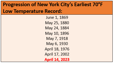
The progression of NYC's earliest 70° temperature record:
-
NYC recorded its earliest 70F minimum temperature on record yesterday. The prior earliest such low temperature occurred on April 17, 2002. It is only the 4th such reading on record in April. Records go back to 1869.
-
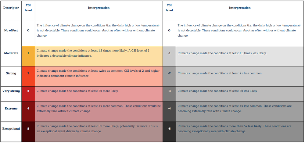
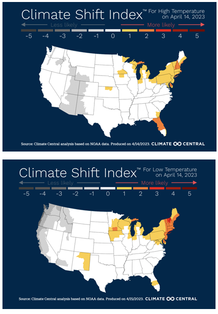
Good charts. It's mostly climate change. I've added Climate Central's instant attribution maps to my above comment.
-
In the big cities, UHI and climate change amplify the warmth. But in cities like New York that have a mature urban footprint, climate change is responsible for most of the recent warming. Today’s heat was made 1.5-4 times more likely due to climate change based on Climate Central’s instant attribution algorithm. Globally, there’s little doubt that climate change is responsible for most of the observed warming.
-
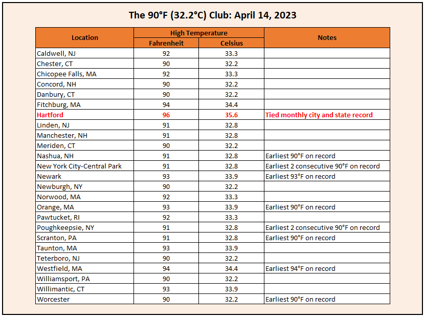
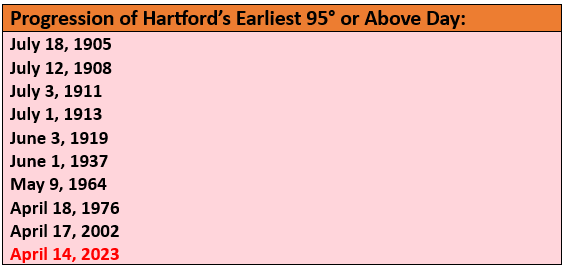
Today was a historic day for early heat in New England. Hartford tied its April record high and established New England's earliest 95° or above reading on record. Records included: Albany: 89° (old record: 83°, 1938 and 1968) Allentown: 88° (old record: 87°, 2018) Bangor: 76° (old record: 74°, 1949) Binghamton: 85° (old record: 79°, 1968) Boston: 83° (old record: 81°, 1945) Bridgeport: 87° (old record: 73°, 1949) ***Hottest temperature so early in the season*** Concord: 90° (old record: 84°, 1870) Hartford: 96° (old record: 82°, 1941) ***Tied monthly city and state record; Earliest 95° temperature in New England*** Islip: 84° (old record: 73°, 1977, 2002, and 2022) Manchester, NH: 91° (old record: 79°, 2014) Mount Pocono, PA: 84° (old record: 82°, 1941) New York City-Central Park: 91° (old record: 85°, 1941) ***Earliest 2 consecutive 90° days*** New York City-JFK Airport: 82° (old record: 78°, 1949) New York City-LaGuardia Airport: 89° (old record: 84°, 1941) Newark: 93° (old record: 88°, 1941 and 2022) ***Earliest 93° or above reading on record*** Portland: 79° (old record: 77°, 1941) Poughkeepsie: 91° (old record: 88°, 1941) Providence: 87° (old record: 83°, 1945) Scranton: 91° (old record: 84°, 1968) ***Earliest 90° reading on record*** Syracuse: 86° (old record: 83°, 1968) Worcester: 90° (old record: 79°, 1938) ***Earliest 90° reading on record*** Cooler weather will follow. Tomorrow will be variably cloudy with some showers. Readings will top out in the middle and perhaps upper 60s. Next week could even see a day where readings struggle to get out of the 50s. Overall, warmth appears likely to define April in much of the East. If the long-range guidance is accurate the first three weeks of the month could put April 2023 on a trajectory that could rank it among the 10 warmest Aprils on record in the northern Middle Atlantic region. Afterward, the latest EPS weeklies suggest that the month could finish with near normal readings. The most recent April case to rank among the 10 warmest was: Boston: 51.7°, 2019 (5th warmest) Bridgeport: 54.0°, 2017 (1st warmest) Islip: 51.9°, 2019 (6th warmest) New Haven: 50.8°, 2022 (6th warmest) New York City-Central Park: 57.2°, 2017 (2nd warmest) New York City-JFK Airport: 55.1°, 2017 (2nd warmest) New York City-LaGuardia Airport: 57.6°, 2017 (2nd warmest) Newark: 57.2°, 2017 (4th warmest) Philadelphia: 59.0°, 2019 (3rd warmest) Poughkeepsie: 53.0°, 2017 (3rd warmest) White Plains: 53.9°, 2017 (2nd warmest) The ENSO Region 1+2 anomaly was +2.7°C and the Region 3.4 anomaly was 0.0°C for the week centered around April 5. For the past six weeks, the ENSO Region 1+2 anomaly has averaged +1.77°C and the ENSO Region 3.4 anomaly has averaged -0.03°C. Neutral ENSO conditions will likely prevail through at least mid-spring. El Niño conditions will likely develop during the summer. The SOI was -9.52 today. The preliminary Arctic Oscillation (AO) was -0.047 today. On April 12 the MJO was in Phase 6 at an amplitude of 2.004 (RMM). The April 11-adjusted amplitude was 2.033 (RMM). Based on sensitivity analysis applied to the latest guidance, there is an implied 94% probability that New York City will have a warmer than normal April (1991-2020 normal). April will likely finish with a mean temperature near 57.5° (3.8° above normal). That would rank as the second warmest April on record.
-
April 12, 1977. The highest temperature in 1976 was 89.
-
They did. That tied the April monthly record from April 19, 1976.
-
Yes, the 2002 heatwave was the earliest on record.
-
Yes. It’s also New England’s earliest 95-degree reading on record.
-
It peaked at 91.
-
Hartford recorded its earliest 95° reading on record: New York City also recorded its earliest two consecutive 90° days. The old record was set during April 16-17, 2002.
-
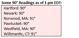
As of 11 am, daily records have already fallen at Hartford, Islip, New York City-JFK Airport, Providence and White Plains. Boston has tied its daily record.
-
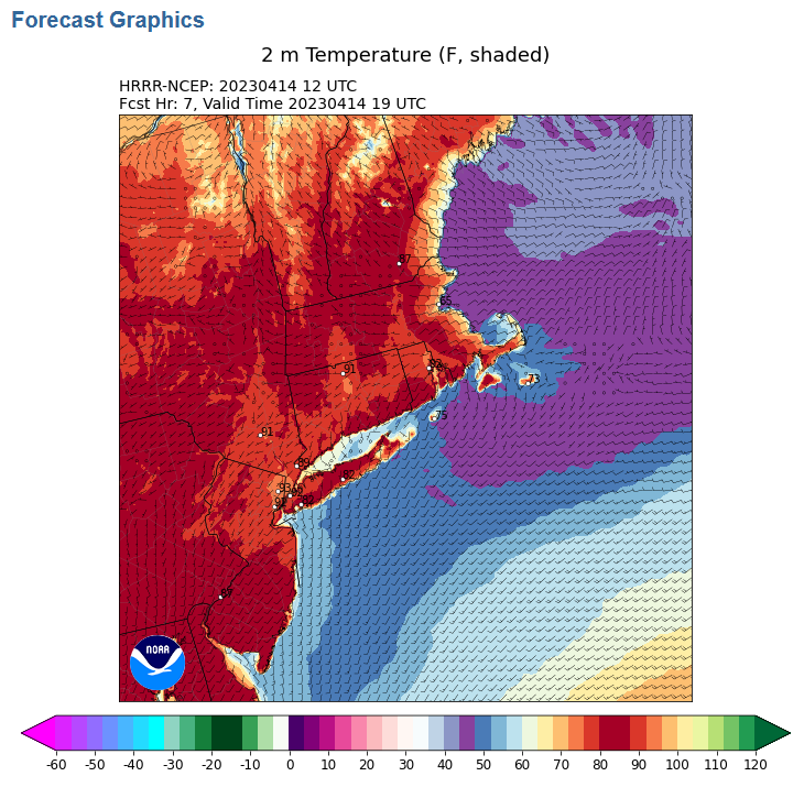
New high temperature records have already been set at Islip and White Plains. New Haven has tied its daily record. The 12z HRRR shows the temperature again rising to 90° or above in New York City and the lower 90s at Newark.
-
On April 7, 2010, JFK reached 87, LGA reached 91, and Central Park hit 92.
-
Under abundant sunshine, temperatures rose to record levels in much of the region. Records included: Albany: 89° (old record: 87°, 1977) Atlantic City: 87° (old record: 83°, 1977 and 2018) Binghamton: 86° (old record: 80°, 1977) Bridgeport: 79° (old record: 74°, 1968) Burlington: 88° (old record: 84°, 1945) ***Highest temperature so early in the season*** Concord: 88° (tied record set in 1945) Hartford: 92° (old record: 86°, 1977) Islip: 84° (old record: 82°, 1977) Manchester, NH: 90° (old record: 77°, 1945 and 1949) ***Highest temperature so early in the season*** Mount Pocono: 82° (old record: 81°, 1977) New York City-Central Park: 90° (old record: 88°, 1977) New York City-JFK Airport: 85° (tied record set in 1977) New York City-LaGuardia Airport: 89° (old record: 85°, 1977) Newark: 92° (old record: 86°, 1977) Ottawa: 85° (old record: 80°, 1945) Poughkeepsie: 90° (old record: 88°, 1945) Providence: 88° (old record: 85°, 1945 and 1977) Salisbury: 87° (old record: 86°, 1977) Scranton: 87° (old record: 85°, 1945) Syracuse: 86° (old record: 85°, 1945) Toronto: 84° (old record: 81°, 1977) Wilmington, DE: 88° (old record: 85°, 1977) Temperatures could reach the middle and upper 80s tomorrow, possibly challenging or breaking additional record highs. Afterward, cooler weather will follow. Next week could even see a day where readings struggle to get out of the 50s. Overall, warmth appears likely to define April in much of the East. If the long-range guidance is accurate the first three weeks of the month could put April 2023 on a trajectory that could rank it among the 10 warmest Aprils on record in the northern Middle Atlantic region. Afterward, the latest EPS weeklies suggest that the month could finish with near normal readings. The most recent April case to rank among the 10 warmest was: Boston: 51.7°, 2019 (5th warmest) Bridgeport: 54.0°, 2017 (1st warmest) Islip: 51.9°, 2019 (6th warmest) New Haven: 50.8°, 2022 (6th warmest) New York City-Central Park: 57.2°, 2017 (2nd warmest) New York City-JFK Airport: 55.1°, 2017 (2nd warmest) New York City-LaGuardia Airport: 57.6°, 2017 (2nd warmest) Newark: 57.2°, 2017 (4th warmest) Philadelphia: 59.0°, 2019 (3rd warmest) Poughkeepsie: 53.0°, 2017 (3rd warmest) White Plains: 53.9°, 2017 (2nd warmest) The ENSO Region 1+2 anomaly was +2.7°C and the Region 3.4 anomaly was 0.0°C for the week centered around April 5. For the past six weeks, the ENSO Region 1+2 anomaly has averaged +1.77°C and the ENSO Region 3.4 anomaly has averaged -0.03°C. Neutral ENSO conditions will likely prevail through at least mid-spring. El Niño conditions will likely develop during the summer. The SOI was +0.21 today. The preliminary Arctic Oscillation (AO) was +0.482 today. On April 11 the MJO was in Phase 6 at an amplitude of 2.033 (RMM). The April 10-adjusted amplitude was 1.921 (RMM). Based on sensitivity analysis applied to the latest guidance, there is an implied 91% probability that New York City will have a warmer than normal April (1991-2020 normal). April will likely finish with a mean temperature near 57.4° (3.7° above normal). That would rank as the second warmest April on record.
-
April 17, 2002 is the earliest.
-
Temperatures surged into the 80s across much of the region following a morning of record high minimum temperatures. Daily record high minimum temperatures included: Bridgeport: 53° (old record: 49°, 2017) Islip: 59° (old record: 51°, 2008) New York City-Central Park: 64° (old record: 58°, 1947 and 2017) New York City-JFK Airport: 56° (old record: 52°, 2017) New York City-LaGuardia Airport: 66° (old record: 54°, 1945, 1996, and 2017) Newark: 64° (old record: 59°, 2017) Temperatures could reach the middle and upper 80s tomorrow and Friday, possibly challenging or breaking some record highs. Some of the more aggressive guidance shows some 90° readings tomorrow. Overall, warmth appears likely to define April in much of the East. If the long-range guidance is accurate the first three weeks of the month could put April 2023 on a trajectory that could rank it among the 10 warmest Aprils on record in the northern Middle Atlantic region. Afterward, the latest EPS weeklies suggest that the month could finish with near normal readings. The most recent April case to rank among the 10 warmest was: Boston: 51.7°, 2019 (5th warmest) Bridgeport: 54.0°, 2017 (1st warmest) Islip: 51.9°, 2019 (6th warmest) New Haven: 50.8°, 2022 (6th warmest) New York City-Central Park: 57.2°, 2017 (2nd warmest) New York City-JFK Airport: 55.1°, 2017 (2nd warmest) New York City-LaGuardia Airport: 57.6°, 2017 (2nd warmest) Newark: 57.2°, 2017 (4th warmest) Philadelphia: 59.0°, 2019 (3rd warmest) Poughkeepsie: 53.0°, 2017 (3rd warmest) White Plains: 53.9°, 2017 (2nd warmest) The ENSO Region 1+2 anomaly was +2.7°C and the Region 3.4 anomaly was 0.0°C for the week centered around April 5. For the past six weeks, the ENSO Region 1+2 anomaly has averaged +1.77°C and the ENSO Region 3.4 anomaly has averaged -0.03°C. Neutral ENSO conditions will likely prevail through at least mid-spring. El Niño conditions will likely develop during the summer. The SOI was +1.73 today. The preliminary Arctic Oscillation (AO) was +1.262 today. On April 10 the MJO was in Phase 6 at an amplitude of 1.918 (RMM). The April 9-adjusted amplitude was 1.724 (RMM). Based on sensitivity analysis applied to the latest guidance, there is an implied 91% probability that New York City will have a warmer than normal April (1991-2020 normal). April will likely finish with a mean temperature near 57.5° (3.8° above normal). That would rank as the second warmest April on record.