

donsutherland1
-
Posts
23,766 -
Joined
Content Type
Profiles
Blogs
Forums
American Weather
Media Demo
Store
Gallery
Everything posted by donsutherland1
-
It is. The "normal" temperature has risen about 1° from 1961-1990 to 1991-2020. The anomalies are measured against an elevated and still warming baseline.
-
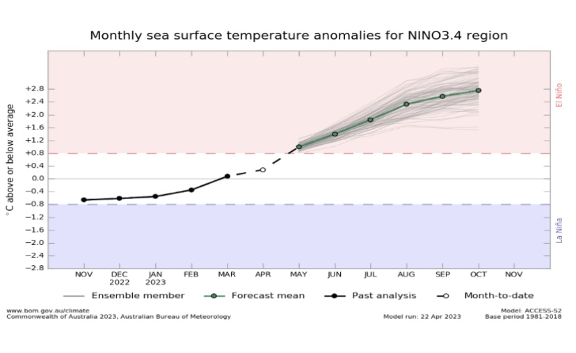
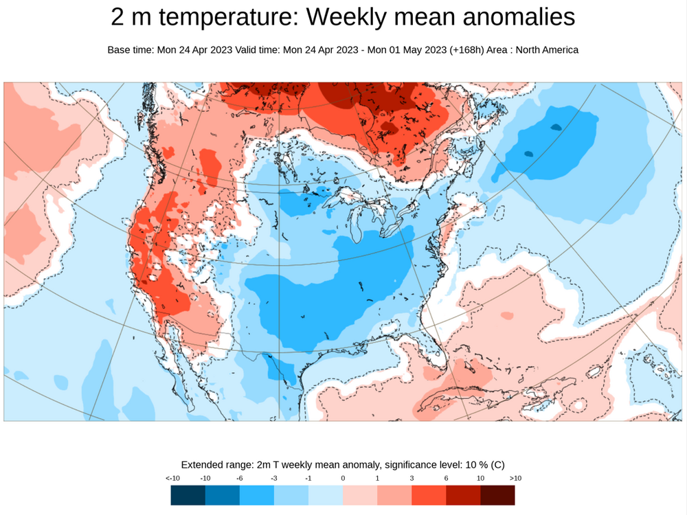
May has gotten off to an unseasonably cool start after a rainy end to an exceptionally warm April. Typically, a very warm April is followed by a somewhat cooler than normal May in the Middle Atlantic region. Whether that will be the case this year remains to be seen. The cool pattern will continue through the opening week of May. Afterward, temperatures will trend toward normal and above normal during the second week of May. The duration and magnitude of this warm period could determine the overall monthly temperature anomaly. The ENSO Region 1+2 anomaly was +2.4°C and the Region 3.4 anomaly was +0.4°C for the week centered around April 26. For the past six weeks, the ENSO Region 1+2 anomaly has averaged +2.37°C and the ENSO Region 3.4 anomaly has averaged +0.13°C. Neutral ENSO conditions will likely prevail through at least mid-spring. El Niño conditions will very likely develop during the summer. The SOI was +12.58 today. The preliminary Arctic Oscillation (AO) was -1.417 today. On April 29 the MJO was in Phase 3 at an amplitude of 1.328 (RMM). The April 28-adjusted amplitude was 1.393 (RMM).
-
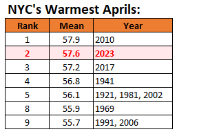
Very heavy rain brought flooding to parts of the region today. LaGuardia Airport saw 2.75" of rain through 7 pm following yesterday's 2.49". The last time LaGuardia Airport saw 2.40" or more rain on two consecutive days was August 12-13, 1955. Some additional rain and showers are likely overnight. A cool pattern remains in place. That pattern will continue through the opening week of May. Afterward, temperatures will trend toward normal and above normal during the second week of May. April 2023 was among the 10 warmest Aprils on record in much of the region. Preliminary monthly temperatures and rankings include: Boston: 50.8° (16th warmest) Bridgeport: 52.0° (5th warmest) Islip: 53.3° (3rd warmest) New Haven: 53.6° (1st warmest) New York City-Central Park: 57.6° (2nd warmest) New York City-JFK Airport 54.4° (3rd warmest) New York City-LaGuardia Airport: 57.0° (3rd warmest) Newark: 58.0° (1st warmest) Philadelphia: 58.3° (6th warmest) Poughkeepsie: 53.0° (3rd warmest) White Plains: 53.5° (3rd warmest) The ENSO Region 1+2 anomaly was +2.5°C and the Region 3.4 anomaly was +0.3°C for the week centered around April 19. For the past six weeks, the ENSO Region 1+2 anomaly has averaged +2.20°C and the ENSO Region 3.4 anomaly has averaged +0.08°C. Neutral ENSO conditions will likely prevail through at least mid-spring. El Niño conditions will very likely develop during the summer. The SOI was +12.76 today. The preliminary Arctic Oscillation (AO) was -1.480 today. On April 28 the MJO was in Phase 2 at an amplitude of 1.391 (RMM). The April 27-adjusted amplitude was 1.761 (RMM).
-
May 2023 temperature forecast contest
donsutherland1 replied to Roger Smith's topic in Weather Forecasting and Discussion
DCA _ NYC _ BOS __ ORD _ ATL _ IAH ___ DEN _ PHX _ SEA -0.8 -0.1 0.7 -0.5 -1.7 -0.4 -0.1 -1.0 1.8 -
A storm continued to bring rain to the New York City area this evening. The largest amounts had fallen in a general area that included Newark and New York City. Through 5 pm, New York City had seen 2.32" of rain. That easily surpassed the old daily mark of 0.91" from 1909. At Newark, 2.89" had fallen, washing away the daily record of 0.82" from 1958. Two-day rainfall at New York City (2.65") and Newark (3.30") was the highest two-day figure since October 26-27, 2021. After a mainly cloudy and cool night with some drizzle and light rain, another moderate to significant rainfall is likely tomorrow into Monday. Coastal flooding could also be possible at times of high tide. A cool pattern remains in place. That pattern will likely continue through the opening week of May. There remains some uncertainty beyond the first week of May, but support for a warming trend toward normal and then above normal during the second week of the month has increased. April 2023 remains on a trajectory that will rank it among the 10 warmest Aprils on record in the northern Middle Atlantic region. The potential exists for some locations to challenge their warmest April on record. A cool end to the month won't be sufficient to avoid top 10 warmth. The most recent April case to rank among the 10 warmest was: Boston: 51.7°, 2019 (5th warmest) Bridgeport: 54.0°, 2017 (1st warmest) Islip: 51.9°, 2019 (6th warmest) New Haven: 50.8°, 2022 (6th warmest) New York City-Central Park: 57.2°, 2017 (2nd warmest) New York City-JFK Airport: 55.1°, 2017 (2nd warmest) New York City-LaGuardia Airport: 57.6°, 2017 (2nd warmest) Newark: 57.2°, 2017 (4th warmest) Philadelphia: 59.0°, 2019 (3rd warmest) Poughkeepsie: 53.0°, 2017 (3rd warmest) White Plains: 53.9°, 2017 (2nd warmest) The ENSO Region 1+2 anomaly was +2.5°C and the Region 3.4 anomaly was +0.3°C for the week centered around April 19. For the past six weeks, the ENSO Region 1+2 anomaly has averaged +2.20°C and the ENSO Region 3.4 anomaly has averaged +0.08°C. Neutral ENSO conditions will likely prevail through at least mid-spring. El Niño conditions will very likely develop during the summer. The SOI was +10.89 today. The preliminary Arctic Oscillation (AO) was -1.686 today. On April 27 the MJO was in Phase 2 at an amplitude of 1.760 (RMM). The April 26-adjusted amplitude was 1.846 (RMM). Based on sensitivity analysis applied to the latest guidance, there is an implied near 100% probability that New York City will have a warmer than normal April (1991-2020 normal). April will likely finish with a mean temperature near 57.7° (4.0° above normal). That would be the second warmest April on record.
-
Earlier today, Richmond received 1.76" rainfall. That broke the daily record of 1.34" from 1923. At 5:45 pm, heavy rain was falling in Philadelphia. That rain will overspread the region this evening. A soaking rain is likely tonight into tomorrow. Much of the region will see a general 0.50"-1.50" of rain with locally higher amounts. Another moderate to significant rainfall is likely Sunday into Monday. A cool pattern remains in place. That pattern will likely continue through the opening week of May. There remains considerable uncertainty beyond the first week of May. Nevertheless, there are some hints that warmth could begin to return to the East while cooler weather returns to the West, as has been the case through most of the winter and spring so far. April 2023 remains on a trajectory that will rank it among the 10 warmest Aprils on record in the northern Middle Atlantic region. The potential exists for some locations to challenge their warmest April on record. A cool end to the month won't be sufficient to avoid top 10 warmth. The most recent April case to rank among the 10 warmest was: Boston: 51.7°, 2019 (5th warmest) Bridgeport: 54.0°, 2017 (1st warmest) Islip: 51.9°, 2019 (6th warmest) New Haven: 50.8°, 2022 (6th warmest) New York City-Central Park: 57.2°, 2017 (2nd warmest) New York City-JFK Airport: 55.1°, 2017 (2nd warmest) New York City-LaGuardia Airport: 57.6°, 2017 (2nd warmest) Newark: 57.2°, 2017 (4th warmest) Philadelphia: 59.0°, 2019 (3rd warmest) Poughkeepsie: 53.0°, 2017 (3rd warmest) White Plains: 53.9°, 2017 (2nd warmest) The ENSO Region 1+2 anomaly was +2.5°C and the Region 3.4 anomaly was +0.3°C for the week centered around April 19. For the past six weeks, the ENSO Region 1+2 anomaly has averaged +2.20°C and the ENSO Region 3.4 anomaly has averaged +0.08°C. Neutral ENSO conditions will likely prevail through at least mid-spring. El Niño conditions will very likely develop during the summer. The SOI was -0.15 today. The preliminary Arctic Oscillation (AO) was -2.064 today. On April 26 the MJO was in Phase 2 at an amplitude of 1.846 (RMM). The April 25-adjusted amplitude was 2.000 (RMM). Based on sensitivity analysis applied to the latest guidance, there is an implied near 100% probability that New York City will have a warmer than normal April (1991-2020 normal). April will likely finish with a mean temperature near 57.8° (4.1° above normal). That would be the second warmest April on record.
-
It’s sad. He either doesn’t know what the greenhouse effect is/the properties of greenhouse gases or he is deliberately posting misleading information.
-
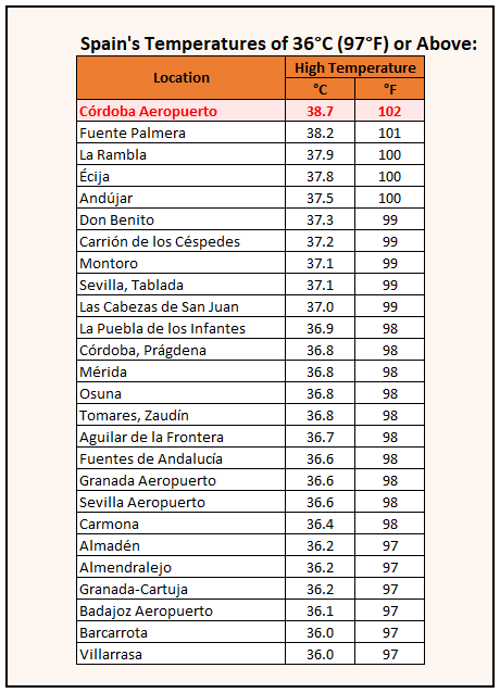
Earlier today, Portugal, Spain, and Morocco experienced their highest temperatures on record during April. The 102° high in Cordoba, Spain set a European April record. In the Middle Atlantic region, cool mainly cloudy weather prevailed. A cool pattern remains in place. That pattern will likely continue through the opening week of May. There remains considerable uncertainty beyond the first week of May. Nevertheless, there are some hints that warmth could begin to return to the East while cooler weather returns to the West, as has been the case through most of the winter and spring so far. The region could experience rain Friday night into Saturday. Afterward, a moderate to perhaps significant rainfall is possible Sunday into Monday. April 2023 remains on a trajectory that will rank it among the 10 warmest Aprils on record in the northern Middle Atlantic region. The potential exists for some locations to challenge their warmest April on record. A cool end to the month won't be sufficient to avoid top 10 warmth. The most recent April case to rank among the 10 warmest was: Boston: 51.7°, 2019 (5th warmest) Bridgeport: 54.0°, 2017 (1st warmest) Islip: 51.9°, 2019 (6th warmest) New Haven: 50.8°, 2022 (6th warmest) New York City-Central Park: 57.2°, 2017 (2nd warmest) New York City-JFK Airport: 55.1°, 2017 (2nd warmest) New York City-LaGuardia Airport: 57.6°, 2017 (2nd warmest) Newark: 57.2°, 2017 (4th warmest) Philadelphia: 59.0°, 2019 (3rd warmest) Poughkeepsie: 53.0°, 2017 (3rd warmest) White Plains: 53.9°, 2017 (2nd warmest) The ENSO Region 1+2 anomaly was +2.5°C and the Region 3.4 anomaly was +0.3°C for the week centered around April 19. For the past six weeks, the ENSO Region 1+2 anomaly has averaged +2.20°C and the ENSO Region 3.4 anomaly has averaged +0.08°C. Neutral ENSO conditions will likely prevail through at least mid-spring. El Niño conditions will very likely develop during the summer. The SOI was +9.30 today. The preliminary Arctic Oscillation (AO) was -1.738 today. On April 25 the MJO was in Phase 1 at an amplitude of 2.000 (RMM). The April 24-adjusted amplitude was 2.000 (RMM). Based on sensitivity analysis applied to the latest guidance, there is an implied near 100% probability that New York City will have a warmer than normal April (1991-2020 normal). April will likely finish with a mean temperature near 57.9° (4.2° above normal). That would tie the record for the warmest April on record.
-
Today was a historic day in Spain. A new national and European April record high temperature was set.
-
A cool pattern is underway. That pattern will likely continue through the opening week of May. There remains considerable uncertainty beyond the first week of May. Nevertheless, there are some hints that warmth could begin to return to the East while cooler weather returns to the West, as has been the case through most of the winter and spring so far. The region could experience rain Friday night into Saturday. Afterward, a moderate to perhaps significant rainfall is possible Sunday into Monday. April 2023 remains on a trajectory that will rank it among the 10 warmest Aprils on record in the northern Middle Atlantic region. The potential exists for some locations to challenge their warmest April on record. A cool end to the month won't be sufficient to avoid top 10 warmth. The most recent April case to rank among the 10 warmest was: Boston: 51.7°, 2019 (5th warmest) Bridgeport: 54.0°, 2017 (1st warmest) Islip: 51.9°, 2019 (6th warmest) New Haven: 50.8°, 2022 (6th warmest) New York City-Central Park: 57.2°, 2017 (2nd warmest) New York City-JFK Airport: 55.1°, 2017 (2nd warmest) New York City-LaGuardia Airport: 57.6°, 2017 (2nd warmest) Newark: 57.2°, 2017 (4th warmest) Philadelphia: 59.0°, 2019 (3rd warmest) Poughkeepsie: 53.0°, 2017 (3rd warmest) White Plains: 53.9°, 2017 (2nd warmest) The ENSO Region 1+2 anomaly was +2.5°C and the Region 3.4 anomaly was +0.3°C for the week centered around April 19. For the past six weeks, the ENSO Region 1+2 anomaly has averaged +2.20°C and the ENSO Region 3.4 anomaly has averaged +0.08°C. Neutral ENSO conditions will likely prevail through at least mid-spring. El Niño conditions will very likely develop during the summer. The SOI was +5.12 today. The preliminary Arctic Oscillation (AO) was -1.924 today. On April 24 the MJO was in Phase 1 at an amplitude of 1.999 (RMM). The April 23-adjusted amplitude was 2.076 (RMM). Based on sensitivity analysis applied to the latest guidance, there is an implied near 100% probability that New York City will have a warmer than normal April (1991-2020 normal). April will likely finish with a mean temperature near 58.0° (4.3° above normal). That would rank April 2023 as the warmest April on record.
-
From Australia’s Bureau of Meteorology: A forecast for a super El Niño.
-
An extended cool period will likely continue through the opening week of May. This sustained period of cooler than normal weather is shown on both the CFSv2 and ECMWF weeklies. There remains considerable uncertainty beyond the first week of May. The region could experience some rain Friday night into Saturday. Afterward, a moderate to perhaps significant rainfall is possible Sunday into Monday. April 2023 remains on a trajectory that will rank it among the 10 warmest Aprils on record in the northern Middle Atlantic region. The potential exists for some locations to challenge their warmest April on record. A cool end to the month won't be sufficient to avoid top 10 warmth. The most recent April case to rank among the 10 warmest was: Boston: 51.7°, 2019 (5th warmest) Bridgeport: 54.0°, 2017 (1st warmest) Islip: 51.9°, 2019 (6th warmest) New Haven: 50.8°, 2022 (6th warmest) New York City-Central Park: 57.2°, 2017 (2nd warmest) New York City-JFK Airport: 55.1°, 2017 (2nd warmest) New York City-LaGuardia Airport: 57.6°, 2017 (2nd warmest) Newark: 57.2°, 2017 (4th warmest) Philadelphia: 59.0°, 2019 (3rd warmest) Poughkeepsie: 53.0°, 2017 (3rd warmest) White Plains: 53.9°, 2017 (2nd warmest) The ENSO Region 1+2 anomaly was +2.5°C and the Region 3.4 anomaly was +0.3°C for the week centered around April 19. For the past six weeks, the ENSO Region 1+2 anomaly has averaged +2.20°C and the ENSO Region 3.4 anomaly has averaged +0.08°C. Neutral ENSO conditions will likely prevail through at least mid-spring. El Niño conditions will very likely develop during the summer. The SOI was -9.52 today. The preliminary Arctic Oscillation (AO) was -1.871 today. On April 23 the MJO was in Phase 1 at an amplitude of 2.074 (RMM). The April 22-adjusted amplitude was 2.023 (RMM). Based on sensitivity analysis applied to the latest guidance, there is an implied near 100% probability that New York City will have a warmer than normal April (1991-2020 normal). April will likely finish with a mean temperature near 58.0° (4.3° above normal). That would rank April 2023 as the warmest April on record.
-
The lack of change in temperature is very impressive.
-
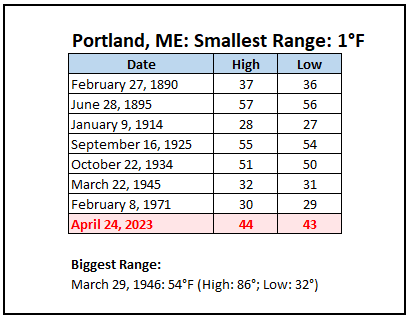
Yesterday, Portland set an April record and tied its all-time record for the smallest daily temperature range on record.
-
An extended cool period will likely continue through the opening week of May. This sustained period of cooler than normal weather is shown on both the CFSv2 and ECMWF weeklies. The opening days of May could also see the first period of much above normal warmth develop in the Pacific Northwest. There remains considerable uncertainty beyond the first week of May. April 2023 remains on a trajectory that will likely rank it among the 10 warmest Aprils on record in the northern Middle Atlantic region. The potential exists for some locations to challenge their warmest April on record. A cool end to the month won't be sufficient to avoid top 10 warmth. The most recent April case to rank among the 10 warmest was: Boston: 51.7°, 2019 (5th warmest) Bridgeport: 54.0°, 2017 (1st warmest) Islip: 51.9°, 2019 (6th warmest) New Haven: 50.8°, 2022 (6th warmest) New York City-Central Park: 57.2°, 2017 (2nd warmest) New York City-JFK Airport: 55.1°, 2017 (2nd warmest) New York City-LaGuardia Airport: 57.6°, 2017 (2nd warmest) Newark: 57.2°, 2017 (4th warmest) Philadelphia: 59.0°, 2019 (3rd warmest) Poughkeepsie: 53.0°, 2017 (3rd warmest) White Plains: 53.9°, 2017 (2nd warmest) The ENSO Region 1+2 anomaly was +2.5°C and the Region 3.4 anomaly was +0.3°C for the week centered around April 19. For the past six weeks, the ENSO Region 1+2 anomaly has averaged +2.20°C and the ENSO Region 3.4 anomaly has averaged +0.08°C. Neutral ENSO conditions will likely prevail through at least mid-spring. El Niño conditions will very likely develop during the summer. The SOI was -24.08 today. The preliminary Arctic Oscillation (AO) was -1.978 today. On April 22 the MJO was in Phase 1 at an amplitude of 2.022 (RMM). The April 21-adjusted amplitude was 1.754 (RMM). Based on sensitivity analysis applied to the latest guidance, there is an implied near 100% probability that New York City will have a warmer than normal April (1991-2020 normal). April will likely finish with a mean temperature near 58.0° (4.3° above normal). That would rank April 2023 as the warmest April on record.
-
The latest ECMWF weeklies for April 24-May 1. The May 1-8 timeframe is also cooler than normal before readings rebound to near normal levels in the East. Parts of the West will see their warmest readings relative to normal so far this year for the current week.
-
Heavy rain yielded to partly sunny skies during the afternoon. In response to the return of the sun, the mercury rose into the middle and upper 60s across the region. A few places topped 70°. Now, cooler air is beginning to filter into the region. An extended cool period will likely take hold and continue into the opening week of May. The opening days of May could also see the first period of much above normal warmth develop in the Pacific Northwest. There remains considerable uncertainty beyond the first week of May. April 2023 remains on a trajectory that will likely rank it among the 10 warmest Aprils on record in the northern Middle Atlantic region. The potential exists for some locations to challenge their warmest April on record. A cool end to the month won't be sufficient to avoid top 10 warmth. The most recent April case to rank among the 10 warmest was: Boston: 51.7°, 2019 (5th warmest) Bridgeport: 54.0°, 2017 (1st warmest) Islip: 51.9°, 2019 (6th warmest) New Haven: 50.8°, 2022 (6th warmest) New York City-Central Park: 57.2°, 2017 (2nd warmest) New York City-JFK Airport: 55.1°, 2017 (2nd warmest) New York City-LaGuardia Airport: 57.6°, 2017 (2nd warmest) Newark: 57.2°, 2017 (4th warmest) Philadelphia: 59.0°, 2019 (3rd warmest) Poughkeepsie: 53.0°, 2017 (3rd warmest) White Plains: 53.9°, 2017 (2nd warmest) The ENSO Region 1+2 anomaly was +2.7°C and the Region 3.4 anomaly was +0.1°C for the week centered around April 12. For the past six weeks, the ENSO Region 1+2 anomaly has averaged +2.03°C and the ENSO Region 3.4 anomaly has averaged +0.02°C. Neutral ENSO conditions will likely prevail through at least mid-spring. El Niño conditions will likely develop during the summer. The SOI was -16.44 today. The preliminary Arctic Oscillation (AO) was -2.497 today. On April 21 the MJO was in Phase 8 at an amplitude of 1.756 (RMM). The April 20-adjusted amplitude was 1.617 (RMM). Based on sensitivity analysis applied to the latest guidance, there is an implied near 100% probability that New York City will have a warmer than normal April (1991-2020 normal). April will likely finish with a mean temperature near 58.0° (4.3° above normal). That would rank April 2023 as the warmest April on record.
-
The current rainstorm has been impressive in parts of the NYC area. Newark has now picked up 1.01" of rain today, which ties the daily mark set in 1986. New York City has seen 1.51" of rain today and a two-day total of 2.19". Back in 2006, a much more intense rainfall occurred with daily amounts reaching 3"-6" across parts of Long Island into Connecticut, NYC and nearby Westchester County. The PNS from that 4/22-23 event is below: 000 NOUS41 KOKX 231935 CCA PNSOKX CTZ005>012-NJZ002>006-011-NYZ067>081-232300- PUBLIC INFORMATION STATEMENT...CORRECTED SPOTTER REPORTS NATIONAL WEATHER SERVICE UPTON NY 335 PM EDT SUN APR 23 2006 THE FOLLOWING ARE UNOFFICIAL RAINFALL OBSERVATIONS TAKEN DURING THE PAST 24 HOURS FOR THE STORM THAT HAS BEEN AFFECTING OUR REGION. APPRECIATION IS EXTENDED TO HIGHWAY DEPARTMENTS...COOPERATIVE OBSERVERS...SKYWARN SPOTTERS AND MEDIA FOR THESE REPORTS. THIS SUMMARY IS ALSO AVAILABLE ON OUR HOME PAGE AT WEATHER.GOV/NYC ********************STORM TOTAL RAINFALL******************** LOCATION STORM TOTAL TIME/DATE COMMENTS RAINFALL OF (INCHES) MEASUREMENT CONNECTICUT ...FAIRFIELD COUNTY... BRIDGEPORT 4.97 200 PM 4/23 ASOS DANBURY 3.20 200 PM 4/23 ASOS ...NEW HAVEN COUNTY... NEW HAVEN/TWEED 3.45 200 PM 4/23 ASOS ...NEW LONDON COUNTY... GROTON/NEW LONDON 0.59 200 PM 4/23 ASOS NEW JERSEY ...BERGEN COUNTY... TETERBORO 2.88 200 PM 4/23 ASOS ...ESSEX COUNTY... NEWARK 1.91 200 PM 4/23 ASOS CALDWELL 1.41 200 PM 4/23 ASOS ...HUDSON COUNTY... HARRISON 2.08 800 AM 4/23 CO-OP NEW YORK ...KINGS COUNTY... BROOKLYN 2.40 800 AM 4/23 CO-OP ...NASSAU COUNTY... PLAINVIEW 4.00 110 PM 4/23 SPOTTER FARMINGDALE 3.71 200 PM 4/23 ASOS LYNBROOK 2.80 850 AM 4/23 SPOTTER ...NEW YORK COUNTY... NYC/CENTRAL PARK 3.57 200 PM 4/23 ASOS ...ORANGE... MIDDLETOWN 1.95 930 AM 4/23 SPOTTER MONTGOMERY 1.12 200 PM 4/23 ASOS ...QUEENS COUNTY... NYC/LA GUARDIA 3.30 200 PM 4/23 ASOS NYC/JFK ARPT 2.88 200 PM 4/23 ASOS ...SUFFOLK COUNTY... HOLBROOK 6.63 145 PM 4/23 OFF DUTY NWS EMPLOYEE ISLIP 5.74 200 PM 4/23 ASOS UPTON 4.06 200 PM 4/23 NWS FORECAST OFFICE SHIRLEY 3.57 200 PM 4/23 ASOS WESTHAMPTON BEACH 1.57 200 PM 4/23 ASOS MONTAUK 0.14 200 PM 4/23 ASOS ...WESTCHESTER... WHITE PLAINS 3.61 200 PM 4/23 ASOS $$
-
Through 9 am EDT, New York City has seen 1.46” of rain today and a 2-day total of 2.14”. That’s the highest daily amount since December 23, 2022 & highest 2-day amount since October 4-5, 2022.
-
Showers and perhaps thundershowers are possible tonight into tomorrow morning. A general 0.50"-1.00" of rain is likely with some locally higher amounts. Afterward, the sun will return and it will remain mild for one more day. A sustained cool period will develop just after the weekend and continue into the opening days of May. The opening days of May could also see the first period of much above normal warmth develop in the Pacific Northwest. A cool period in the East is supported by the MJO's having moved into Phase 8, along with the development of strong Atlantic blocking. That blocking is forecast to fade during the first week of May leading to the possible development of a return of warmer conditions during the second week of the month. Given the timeframe involved, there remains considerable uncertainty beyond the first week of May. April 2023 remains on a trajectory that will likely rank it among the 10 warmest Aprils on record in the northern Middle Atlantic region. The potential exists for some locations to challenge their warmest April on record. A cool end to the month won't be sufficient to avoid top 10 warmth. The most recent April case to rank among the 10 warmest was: Boston: 51.7°, 2019 (5th warmest) Bridgeport: 54.0°, 2017 (1st warmest) Islip: 51.9°, 2019 (6th warmest) New Haven: 50.8°, 2022 (6th warmest) New York City-Central Park: 57.2°, 2017 (2nd warmest) New York City-JFK Airport: 55.1°, 2017 (2nd warmest) New York City-LaGuardia Airport: 57.6°, 2017 (2nd warmest) Newark: 57.2°, 2017 (4th warmest) Philadelphia: 59.0°, 2019 (3rd warmest) Poughkeepsie: 53.0°, 2017 (3rd warmest) White Plains: 53.9°, 2017 (2nd warmest) The ENSO Region 1+2 anomaly was +2.7°C and the Region 3.4 anomaly was +0.1°C for the week centered around April 12. For the past six weeks, the ENSO Region 1+2 anomaly has averaged +2.03°C and the ENSO Region 3.4 anomaly has averaged +0.02°C. Neutral ENSO conditions will likely prevail through at least mid-spring. El Niño conditions will likely develop during the summer. The SOI was -26.39 today. The preliminary Arctic Oscillation (AO) was -3.255 today. On April 20 the MJO was in Phase 8 at an amplitude of 1.615 (RMM). The April 19-adjusted amplitude was 1.635 (RMM). Based on sensitivity analysis applied to the latest guidance, there is an implied near 100% probability that New York City will have a warmer than normal April (1991-2020 normal). April will likely finish with a mean temperature near 58.0° (4.3° above normal). That would rank April 2023 as the warmest April on record.
-
Some photos from Earth Day at the New York Botanical Garden. It was mostly cloudy with a few intervals of sunshine. Temperatures were in the middle 60s.


-
Tomorrow will be variably cloudy. There could be some fog and drizzle in coastal areas. Showers and perhaps thundershowers are possible tomorrow night into Sunday morning. A sustained cool period will develop just after the weekend and continue into the opening days of May. The opening days of May could also see the first period of much above normal warmth develop in the Pacific Northwest. A cool period in the East is supported by the MJO's having moved into Phase 8, along with the development of strong Atlantic blocking. That blocking is forecast to fade during the first week of May leading to the possible development of a return of warmer conditions during the second week of the month. Given the timeframe involved, there remains considerable uncertainty beyond the first week of May. April 2023 remains on a trajectory that will likely rank it among the 10 warmest Aprils on record in the northern Middle Atlantic region. The potential exists for some locations to challenge their warmest April on record. A cool end to the month won't be sufficient to avoid top 10 warmth. The most recent April case to rank among the 10 warmest was: Boston: 51.7°, 2019 (5th warmest) Bridgeport: 54.0°, 2017 (1st warmest) Islip: 51.9°, 2019 (6th warmest) New Haven: 50.8°, 2022 (6th warmest) New York City-Central Park: 57.2°, 2017 (2nd warmest) New York City-JFK Airport: 55.1°, 2017 (2nd warmest) New York City-LaGuardia Airport: 57.6°, 2017 (2nd warmest) Newark: 57.2°, 2017 (4th warmest) Philadelphia: 59.0°, 2019 (3rd warmest) Poughkeepsie: 53.0°, 2017 (3rd warmest) White Plains: 53.9°, 2017 (2nd warmest) The ENSO Region 1+2 anomaly was +2.7°C and the Region 3.4 anomaly was +0.1°C for the week centered around April 12. For the past six weeks, the ENSO Region 1+2 anomaly has averaged +2.03°C and the ENSO Region 3.4 anomaly has averaged +0.02°C. Neutral ENSO conditions will likely prevail through at least mid-spring. El Niño conditions will likely develop during the summer. The SOI was -19.97 today. The preliminary Arctic Oscillation (AO) was -3.455 today. On April 19 the MJO was in Phase 8 at an amplitude of 1.635 (RMM). The April 18-adjusted amplitude was 1.766 (RMM). Based on sensitivity analysis applied to the latest guidance, there is an implied near 100% probability that New York City will have a warmer than normal April (1991-2020 normal). April will likely finish with a mean temperature near 58.0° (4.3° above normal). That would rank April 2023 as the warmest April on record.
-
Tomorrow will be a warm day except along the immediate coastal plain. The temperature could reach the upper 70s and perhaps lower 80s tomorrow in southern New Jersey and Philadelphia and lower 70s in New York City. A more sustained cool period could develop during or just after the weekend and continue into the opening days of May. April 2023 remains on a trajectory that will likely rank it among the 10 warmest Aprils on record in the northern Middle Atlantic region. The potential exists for some locations to challenge their warmest April on record. A cool end to the month won't be sufficient to avoid top 10 warmth. The most recent April case to rank among the 10 warmest was: Boston: 51.7°, 2019 (5th warmest) Bridgeport: 54.0°, 2017 (1st warmest) Islip: 51.9°, 2019 (6th warmest) New Haven: 50.8°, 2022 (6th warmest) New York City-Central Park: 57.2°, 2017 (2nd warmest) New York City-JFK Airport: 55.1°, 2017 (2nd warmest) New York City-LaGuardia Airport: 57.6°, 2017 (2nd warmest) Newark: 57.2°, 2017 (4th warmest) Philadelphia: 59.0°, 2019 (3rd warmest) Poughkeepsie: 53.0°, 2017 (3rd warmest) White Plains: 53.9°, 2017 (2nd warmest) The ENSO Region 1+2 anomaly was +2.7°C and the Region 3.4 anomaly was +0.1°C for the week centered around April 12. For the past six weeks, the ENSO Region 1+2 anomaly has averaged +2.03°C and the ENSO Region 3.4 anomaly has averaged +0.02°C. Neutral ENSO conditions will likely prevail through at least mid-spring. El Niño conditions will likely develop during the summer. The SOI was +2.88 today. The preliminary Arctic Oscillation (AO) was -2.955 today. On April 18 the MJO was in Phase 7 at an amplitude of 1.764 (RMM). The April 17-adjusted amplitude was 1.697 (RMM). Based on sensitivity analysis applied to the latest guidance, there is an implied 99% probability that New York City will have a warmer than normal April (1991-2020 normal). April will likely finish with a mean temperature near 58.0° (4.3° above normal). That would rank April 2023 as the warmest April on record.
-
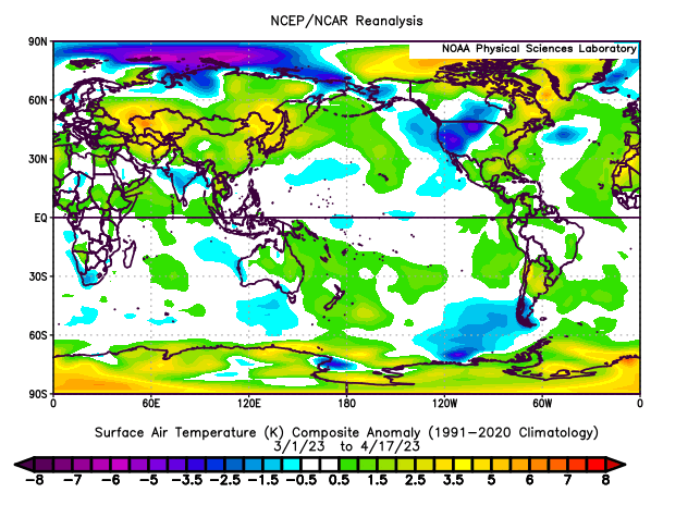
Through mid-spring, most of the Northern Hemisphere has seen a warmer than normal spring. Cold has remained largely confined to western North America while the East has been exceptionally warm.
-
Milder air will continue to overspread the region tomorrow. The temperature could reach the upper 70s and perhaps lower 80s on Friday in southern New Jersey and Philadelphia and lower 70s in New York City. A more sustained cool period could develop during or just after the weekend and continue into the opening days of May. April 2023 remains on a trajectory that will likely rank it among the 10 warmest Aprils on record in the northern Middle Atlantic region. The potential exists for some locations to challenge their warmest April on record. A cool end to the month won't be sufficient to avoid top 10 warmth. The most recent April case to rank among the 10 warmest was: Boston: 51.7°, 2019 (5th warmest) Bridgeport: 54.0°, 2017 (1st warmest) Islip: 51.9°, 2019 (6th warmest) New Haven: 50.8°, 2022 (6th warmest) New York City-Central Park: 57.2°, 2017 (2nd warmest) New York City-JFK Airport: 55.1°, 2017 (2nd warmest) New York City-LaGuardia Airport: 57.6°, 2017 (2nd warmest) Newark: 57.2°, 2017 (4th warmest) Philadelphia: 59.0°, 2019 (3rd warmest) Poughkeepsie: 53.0°, 2017 (3rd warmest) White Plains: 53.9°, 2017 (2nd warmest) The ENSO Region 1+2 anomaly was +2.7°C and the Region 3.4 anomaly was +0.1°C for the week centered around April 12. For the past six weeks, the ENSO Region 1+2 anomaly has averaged +2.03°C and the ENSO Region 3.4 anomaly has averaged +0.02°C. Neutral ENSO conditions will likely prevail through at least mid-spring. El Niño conditions will likely develop during the summer. The SOI was +4.47 today. The preliminary Arctic Oscillation (AO) was -2.459 today. On April 17 the MJO was in Phase 7 at an amplitude of 1.697 (RMM). The April 16-adjusted amplitude was 1.631 (RMM). Based on sensitivity analysis applied to the latest guidance, there is an implied 99% probability that New York City will have a warmer than normal April (1991-2020 normal). April will likely finish with a mean temperature near 58.0° (4.3° above normal). That would rank April 2023 as the warmest April on record.


