donsutherland1
-
Posts
22,981 -
Joined
Content Type
Profiles
Blogs
Forums
American Weather
Media Demo
Store
Gallery
Everything posted by donsutherland1
-
It's bad. Montreal reached 10° this morning for the first time this winter. The previous latest first 10° temperature occurred on December 29, 2015. Before that, the record was December 28, 2001.
-
2022 surpassed the ocean set record that was set just last year. Most recently, such heat records were also set in 2019 and 2020. Excerpts from a newly-published report: Driven by anthropogenic greenhouse gas emissions, there is an energy imbalance in the Earth’s climate system. More than 90% of the excess heat accumulated in the climate system is deposited in the world’s oceans. The ocean heat content (OHC) influences ocean–atmosphere interactions by providing thermal inertia to sea surface temperatures and thus exerts considerable control over the world’s weather. Rising ocean temperatures bolster the energy exchanges from ocean to atmosphere, increase the quantity of atmospheric moisture, and change the patterns of precipitation and temperature globally... [G]lobal OHC has increased steadily, regardless of the status of ENSO, owing to anthropogenic influences. When considered on an annual basis, 2022 is the hottest year ever recorded in the world’s oceans. Its OHC exceeds that of 2021 by 10.9 ± 8.3 ZJ according to IAP/CAS data, and by 9.1 ± 8.7 ZJ according to NCEI/NOAA data (for the 0–2000 m water depth)... The complete paper can be found here.
-
It is. Hopefully, its days are numbered.
-
WAR is what "Mother Nature" declared on our snow season. WAR = West Atlantic Ridge
-
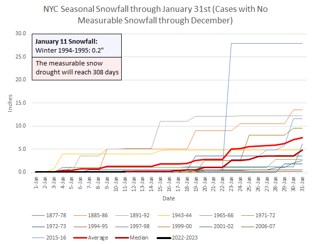
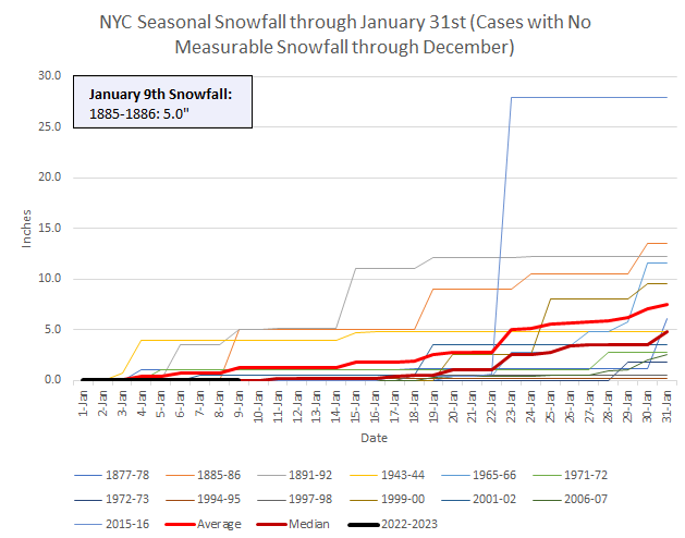
Central Park's measurable snow drought will reach 308 consecutive days today, which will rank as the 6th longest such streak. In addition, Winter 2022-2023 will become just the 7th winter to go through January 11th without any measurable snowfall.
-
Morning thoughts… Clouds will increase during the afternoon or evening following a variably cloudy morning. High temperatures will reach the lower and middle 40s in most areas. Likely high temperatures around the region include: New York City (Central Park): 40° Newark: 42° Philadelphia: 45° Rain is likely tomorrow night into Friday. Normals: New York City: 30-Year: 39.4°; 15-Year: 40.3° Newark: 30-Year: 39.9°; 15-Year: 41.0° Philadelphia: 30-Year: 41.2°; 15-Year: 42.1°
-
Tomorrow will be partly cloudy with readings that are a bit above normal.Clouds will increase tomorrow night as a storm moves toward Lake Erie and then up the St. Lawrence River Valley afterward. That storm will bring a period of rain to the region Thursday night into Friday. Following the storm, a seasonably cool air mass will overspread the region for the close of the weekend. However, milder weather will follow early next week. The ENSO Region 1+2 anomaly was -0.3°C and the Region 3.4 anomaly was -0.7°C for the week centered around December 28. For the past six weeks, the ENSO Region 1+2 anomaly has averaged -0.48°C and the ENSO Region 3.4 anomaly has averaged -0.87°C. La Niña conditions will likely persist through mid-winter before fading to neutral conditions. The SOI was +3.96 today. The preliminary Arctic Oscillation (AO) was -1.294 today. On January 8 the MJO was in Phase 7 at an amplitude of 0.870 (RMM). The January 7-adjusted amplitude was 0.673 (RMM). Based on sensitivity analysis applied to the latest guidance, there is an implied 98% probability that New York City will have a warmer than normal January (1991-2020 normal). January will likely finish with a mean temperature near 40.6° (6.9° above normal).
-
Winters 1915-16 and 1916-17 were the first with two consecutive 50" amounts. Later, Winters 2009-10/2010-11 and 2013-14/2014-15 matched that outcome.
-
Least snowfall during meteorological winter (Central Park): 1. 0.5", 1997-1998 (Season total: 5.5") 2. 1.1", 1918-1919 (Season total: 3.8") 3. 2.6", 1972-1973 (Season total: 2.8") 4. 2.7", 1931-1932 (Season total: 5.3") 5. 3.2", 1991-1992 (Season total: 12.6") 6. 3.5", 2001-2002 (Season total: 3.5") 7. 3.7", 2018-2019 (Season total: 20.5") 8. 4.5", 2011-2012 (Season total: 7.4") 9. 4.8", 2019-2020 (Season total: 4.8") 10. 5.0", 1989-1990 (Season total: 13.4") Most snowfall during meteorological winter (Central Park): 1. 60.9", 2010-2011 (Season total: 61.9") 2. 59.1", 1947-1948 (Season total: 63.9") 3. 58.8", 1995-1996 (Season total: 75.6") 4. 57.3", 2013-2014 (Season total: 57.4") 5. 56.3", 1872-1873 (Season total: 60.2") 6. 53.5", 1960-1961 (Season total: 54.7") 7. 51.4", 2009-2010 (Season total: 51.4") 8. 51.3", 1922-1923 (Season total: 60.4") 9. 45.9", 1904-1905 (Season total: 48.2") 10. 45.3", 1993-1994 (Season total: 53.4")
-
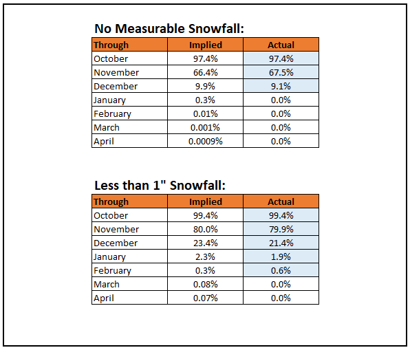
Today will become the 307th consecutive day without measurable snowfall in Central Park. That ties March 5, 1891-January 5, 1892 as the 6th longest such stretch. Winter 2022-2023 will become just the 8th winter on record that has seen no measurable snowfall through January 10th. Even as the measurable snow drought looks likely to continue through the near-term, the statistical probability of Central Park's having less than 1" seasonal snowfall is very low (a "near miss" occurred during Winter 1997-1998. The statistical probability of seeing no measurable snowfall is exceedingly low. Note: With the warming climate, the actual probabilities are likely higher than those reflected by the implied probabilities derived from Central Park's 1869-2022 climate record. For example, since 1990 the implied probabilities of no measurable snowfall in Central Park through December and January are 24.9% and 0.8% respectively. The actual probabilities since 1990 have been 21.2% and 0.0%.
-
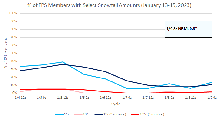
The updated EPS ensemble guidance for New York City is below. The probability of 1" or more snowfall has declined further. The National Blend of Models currently shows no accumulation for New York City.
-
Morning thoughts… It will be variably cloudy and mild. High temperatures will reach the lower and middle 40s in most areas. Likely high temperatures around the region include: New York City (Central Park): 43° Newark: 46° Philadelphia: 45° Dry and mild weather will continue through midweek. Normals: New York City: 30-Year: 39.5°; 15-Year: 40.3° Newark: 30-Year: 39.9°; 15-Year: 41.1° Philadelphia: 30-Year: 41.3°; 15-Year: 42.2°
-
The next several days will be largely dry and mild. Afterward, a storm could bring some rain to the region Friday into Saturday. There remains a low probability of measurable snowfall in New York City, but such an outcome is not assured. Following the storm, a seasonably cool air mass will overspread the region. However, milder weather will follow quickly. The ENSO Region 1+2 anomaly was -0.3°C and the Region 3.4 anomaly was -0.7°C for the week centered around December 28. For the past six weeks, the ENSO Region 1+2 anomaly has averaged -0.48°C and the ENSO Region 3.4 anomaly has averaged -0.87°C. La Niña conditions will likely persist through mid-winter before fading to neutral conditions. The SOI was +9.80 today. The preliminary Arctic Oscillation (AO) was -1.226 today. On January 7 the MJO was in Phase 7 at an amplitude of 0.669 (RMM). The January 6-adjusted amplitude was 0.997 (RMM). Based on sensitivity analysis applied to the latest guidance, there is an implied 97% probability that New York City will have a warmer than normal January (1991-2020 normal). January will likely finish with a mean temperature near 40.6° (6.9° above normal).
-
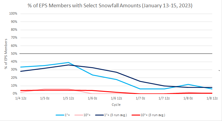
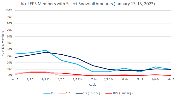
Prospects for measurable snow in New York City during the January 13-15 period remain low.
-
Winter 2022-2023 is poised to become just the 8th winter on record where Central Park had seen no measurable snowfall through January 9th.
-
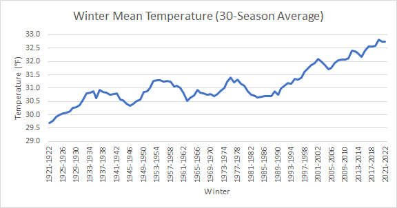
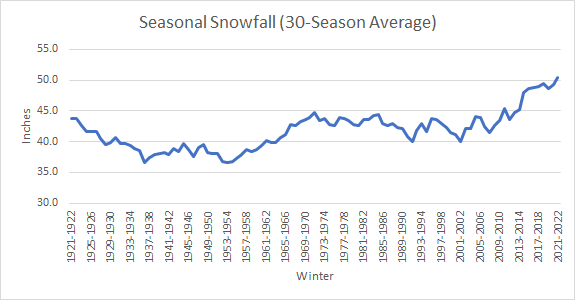
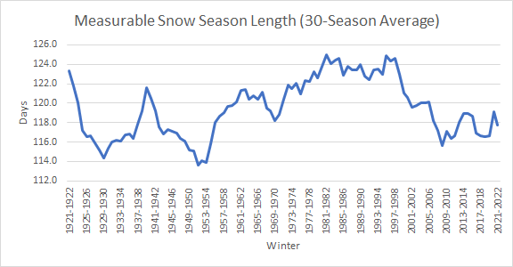
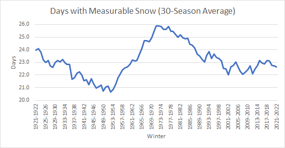
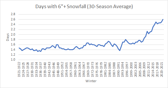
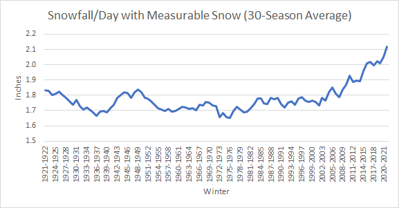
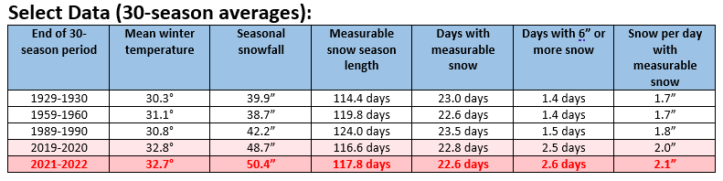
Given the discussion about snowfall and Boston's climate, some 100-year charts are below. Select findings: Winter temperatures (December-February) are warming and now routinely average or exceed 32°F Snowfall per day with measurable snowfall has recently been increasing The number of days with 6" or more snowfall has recently been increasing (this outcome would be expected with climate change during initial warming where the atmosphere holds more moisture, but it remains sufficiently cold for snow). If this is the case, one should begin to see fewer days with snowfall but a larger share with significant snowfall. It's somewhat early to make that call, but 5 of the 10 largest stretches without daily snowfall of 1" or more and 10 of the 20 largest stretches without daily snowfall of 1" or more have occurred since 2000. In part, aside from internal variability (which occurs within the context an enhanced greenhouse effect), the increase in the frequency of days with significant snowfall (6" or more), may be contributing to the recent increase in seasonal snowfall.
-
Only at LGA: 2001-02.
-
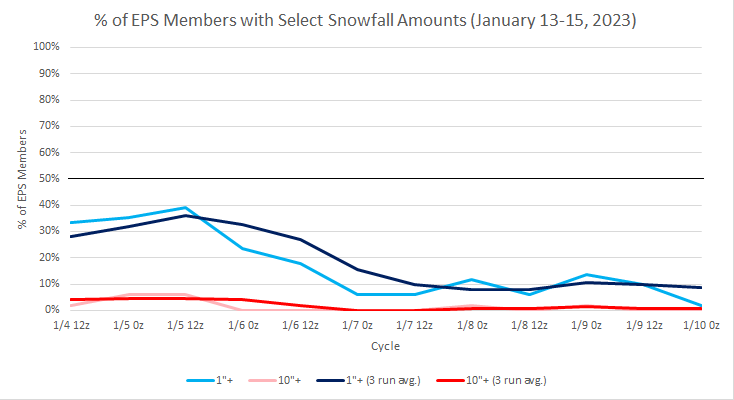
EPS guidance for NYC (January 13-15 period):
-
Morning thoughts… Light precipitation will end this morning. Clouds will give way to sunshine during the late morning or afternoon. High temperatures will reach the lower and middle 40s in most areas. Likely high temperatures around the region include: New York City (Central Park): 45° Newark: 47° Philadelphia: 47° Dry and mild weather will continue through midweek. Normals: New York City: 30-Year: 39.5°; 15-Year: 40.5° Newark: 30-Year: 40.0°; 15-Year: 41.2° Philadelphia: 30-Year: 41.4°; 15-Year: 42.3°
-
Statistically, a 50-degree December would be the equivalent of a 45.8-degree January (1991-2020 baseline) at Central Park. The December 2015 average would be the equivalent of a 46.6-degree January. The existing January record, which was set in 1932, is 43.2 degrees.
-
JFK: None LGA: 1998 and 2002 NYC: 1998
-
The 18z GFS showed about 1" of snow on Bufkit for LGA. The 18z NAM was lower. The National Blend of Models showed no accumulation. Overall, the idea of little or no accumulation seems reasonable. Thus, there is some potential for the first measurable snowfall of the season tomorrow in New York City, but such an outcome is not guaranteed.
-
Advancing cloud shield.
-
Clouds will increase overnight and light precipitation will overspread the region. Light precipitation will continue into tomorrow. New York City and coastal areas will see some light rain and snow. Little or no accumulation is likely. Interior sections could pick up a coating of snow. Mainly dry and mild weather will return following the precipitation. The once moderate support for snowfall during the January 13-15 period diminished sharply. Just 6% of 12z EPS members show 1" or more snow for New York City. 2022 became the 14th year during which New York City received no measurable snowfall through December 31st. During the 13 prior years, mean seasonal snowfall was 16.0" (median seasonal snowfall: 16.3"). Just 8% of those winters rallied to see 30" or more seasonal snowfall. 31% of those winters wound up with less than 10" of seasonal snowfall. Just under half (46%) had 20" or more seasonal snowfall. The lowest seasonal snowfall for those cases of 2.8" was recorded in 1972-1973. The highest seasonal snowfall for those cases was 32.8", which occurred during 2015-2016. The ENSO Region 1+2 anomaly was -0.3°C and the Region 3.4 anomaly was -0.7°C for the week centered around December 28. For the past six weeks, the ENSO Region 1+2 anomaly has averaged -0.48°C and the ENSO Region 3.4 anomaly has averaged -0.87°C. La Niña conditions will likely persist through mid-winter before fading to neutral conditions. The SOI was +22.15 today. The preliminary Arctic Oscillation (AO) was -1.264 today. On January 6 the MJO was in Phase 7 at an amplitude of 0.996 (RMM). The January 5-adjusted amplitude was 1.041 (RMM). Based on sensitivity analysis applied to the latest guidance, there is an implied 97% probability that New York City will have a warmer than normal January (1991-2020 normal). January will likely finish with a mean temperature near 40.5° (6.8° above normal).
-
Latest EPS ensembles concerning January 13-15: