

donsutherland1
-
Posts
23,765 -
Joined
Content Type
Profiles
Blogs
Forums
American Weather
Media Demo
Store
Gallery
Everything posted by donsutherland1
-
DCA _ NYC _ BOS __ ORD _ ATL _ IAH __ DEN _ PHX _ SEA 0.5 1.0 1.0 1.0 0.3 1.0 1.2 1.0 0.5 101 100 98 96 97 104 101 118 97
-
Tomorrow will start off with cool readings in the upper 50s in New York City and lower to middle 50s outside the City. The temperature will then recover to the middle and upper 70s. A wawrm weekend with highs in the upper 70s and lower 80s lies ahead. Afterward, most of next week will be dry with temperatures topping out in the upper 70s and lower 80s. Warm spots could reach the middle 80s. The latest summer guidance continues to suggest a warmer to much warmer than normal summer lies ahead. The ENSO Region 1+2 anomaly was -1.1°C and the Region 3.4 anomaly was +0.2°C for the week centered around May 22. For the past six weeks, the ENSO Region 1+2 anomaly has averaged -0.40°C and the ENSO Region 3.4 anomaly has averaged +0.45°C. Neutral conditions are imminent. The SOI was +15.95 today. The preliminary Arctic Oscillation (AO) was +0.169 yesterday. On May 28 the MJO was in Phase 3 at an amplitude of 1.457 (RMM). The May 27-adjusted amplitude was 1.609 (RMM). Based on sensitivity analysis applied to the latest guidance, there is an implied near 100% probability that New York City will have a warmer than normal May (1991-2020 normal). May will likely finish with a mean temperature near 65.1° (1.9° above normal).
- 1,603 replies
-
- 1
-

-
- spring
- cool temps
- (and 3 more)
-
Showers and possible thundershowers are possible tonight into the early morning. Afterward, tomorrow and Friday will see highs mainly in the lower 70s. Readings could return to the upper 70s and lower 80s during the weekend. The latest summer guidance continues to suggest a warmer to much warmer than normal summer lies ahead. The ENSO Region 1+2 anomaly was -1.1°C and the Region 3.4 anomaly was +0.2°C for the week centered around May 22. For the past six weeks, the ENSO Region 1+2 anomaly has averaged -0.40°C and the ENSO Region 3.4 anomaly has averaged +0.45°C. Neutral conditions are imminent. The SOI was +15.95 today. The preliminary Arctic Oscillation (AO) was +0.147 today. On May 27 the MJO was in Phase 3 at an amplitude of 1.609 (RMM). The May 26-adjusted amplitude was 1.691 (RMM). Based on sensitivity analysis applied to the latest guidance, there is an implied near 100% probability that New York City will have a warmer than normal May (1991-2020 normal). May will likely finish with a mean temperature near 65.2° (2.0° above normal).
-
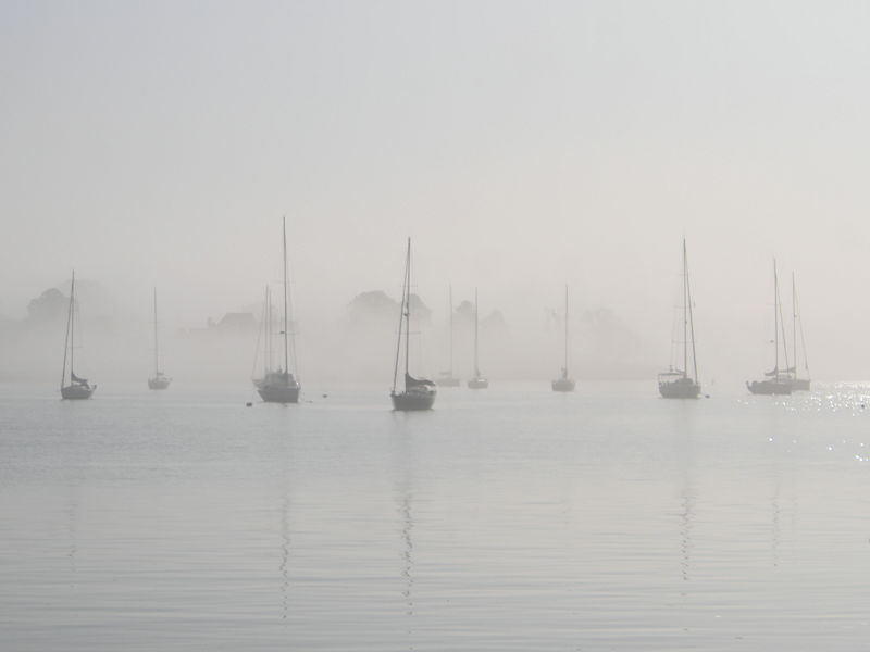
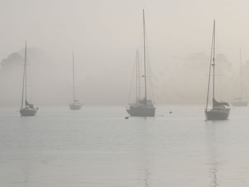
Two photos of this morning's fog:
- 1,603 replies
-
- 6
-
-
- spring
- cool temps
- (and 3 more)
-
I'm not sure. The climate baseline changes, so there may be differences depending which baseline is utilized.
-
Showers and thundershowers are possible tomorrow. Afterward, Thursday and Friday will see highs mainly in the lower 70s. Readings could return to the upper 70s and lower 80s during the weekend. The latest summer guidance continues to suggest a warmer to much warmer than normal summer lies ahead. The ENSO Region 1+2 anomaly was -1.1°C and the Region 3.4 anomaly was +0.2°C for the week centered around May 22. For the past six weeks, the ENSO Region 1+2 anomaly has averaged -0.40°C and the ENSO Region 3.4 anomaly has averaged +0.45°C. Neutral conditions are imminent. The SOI was +11.20 today. The preliminary Arctic Oscillation (AO) was +0.411 today. On May 26 the MJO was in Phase 3 at an amplitude of 1.691 (RMM). The May 25-adjusted amplitude was 1.584 (RMM). Based on sensitivity analysis applied to the latest guidance, there is an implied near 100% probability that New York City will have a warmer than normal May (1991-2020 normal). May will likely finish with a mean temperature near 65.3° (2.1° above normal).
-
Probably not until at least late fall. But that’s not guaranteed.
-
Tomorrow will be partly to mostly sunny and warm. The temperature will rise into the lower 80s. A few warmer spots could top out in the middle 80s. Cooler air will begin to arrive on Wednesday with the temperature reaching the upper 70s. Thursday and Friday will see highs mainly in the lower 70s. The latest summer guidance continues to suggest a warmer to much warmer than normal summer lies ahead. The ENSO Region 1+2 anomaly was -1.1°C and the Region 3.4 anomaly was +0.2°C for the week centered around May 15. For the past six weeks, the ENSO Region 1+2 anomaly has averaged -0.25°C and the ENSO Region 3.4 anomaly has averaged +0.57°C. Neutral conditions are imminent. The SOI was +9.44 yesterday. The preliminary Arctic Oscillation (AO) was +0.381 today. On May 25 the MJO was in Phase 3 at an amplitude of 1.584 (RMM). The May 24-adjusted amplitude was 1.671 (RMM). Based on sensitivity analysis applied to the latest guidance, there is an implied near 100% probability that New York City will have a warmer than normal May (1991-2020 normal). May will likely finish with a mean temperature near 65.3° (2.1° above normal).
- 1,603 replies
-
- 1
-

-
- spring
- cool temps
- (and 3 more)
-
Showers and thunderstorms are likely tomorrow, even as there could be some sunshine. A general 0.50"-1.00" rainfall with locally higher amounts is likely. Following the rainfall, Tuesday will likely see the mercury rise into the lower 80s. Cooler air will arrive to end the work week. The latest summer guidance continues to suggest a warmer to much warmer than normal summer lies ahead. The ENSO Region 1+2 anomaly was -1.1°C and the Region 3.4 anomaly was +0.2°C for the week centered around May 15. For the past six weeks, the ENSO Region 1+2 anomaly has averaged -0.25°C and the ENSO Region 3.4 anomaly has averaged +0.57°C. Neutral conditions are imminent. The SOI was +9.44 today. The preliminary Arctic Oscillation (AO) was +0.554 today. On May 24 the MJO was in Phase 3 at an amplitude of 1.671 (RMM). The May 23-adjusted amplitude was 1.719 (RMM). Based on sensitivity analysis applied to the latest guidance, there is an implied 99% probability that New York City will have a warmer than normal May (1991-2020 normal). May will likely finish with a mean temperature near 65.1° (1.9° above normal).
-
I have some concerns for late summer/early fall if the pattern evolves as I suspect it will.
- 1,603 replies
-
- 1
-
-
- spring
- cool temps
- (and 3 more)
-
Tomorrow will be another warm day with readings topping out mainly in the upper 70s and lower 80s. Temperatures will generally remain near or somewhat above normal through the remainder of May. Rain will overspread the region on Memorial Day. A general 0.50"-1.00" rainfall with locally higher amounts is likely. The latest summer guidance continues to suggest a warmer to much warmer than normal summer lies ahead. The ENSO Region 1+2 anomaly was -1.1°C and the Region 3.4 anomaly was +0.2°C for the week centered around May 15. For the past six weeks, the ENSO Region 1+2 anomaly has averaged -0.25°C and the ENSO Region 3.4 anomaly has averaged +0.57°C. Neutral conditions are imminent. The SOI was +1.17 today. The preliminary Arctic Oscillation (AO) was +0.772 today. On May 23 the MJO was in Phase 3 at an amplitude of 1.719 (RMM). The May 22-adjusted amplitude was 1.691 (RMM). Based on sensitivity analysis applied to the latest guidance, there is an implied 97% probability that New York City will have a warmer than normal May (1991-2020 normal). May will likely finish with a mean temperature near 65.1° (1.9° above normal).
-
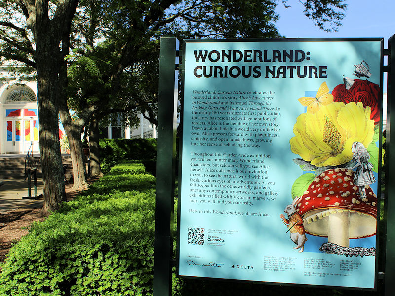
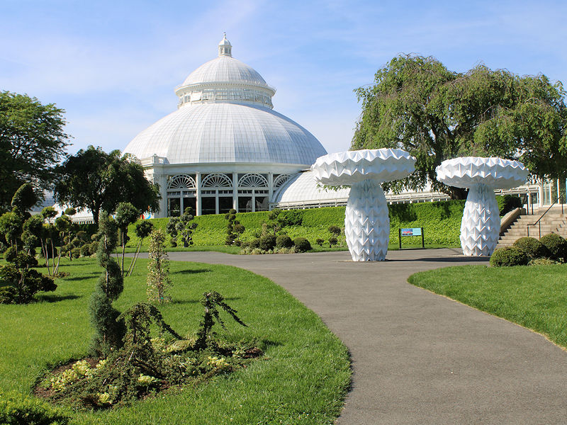
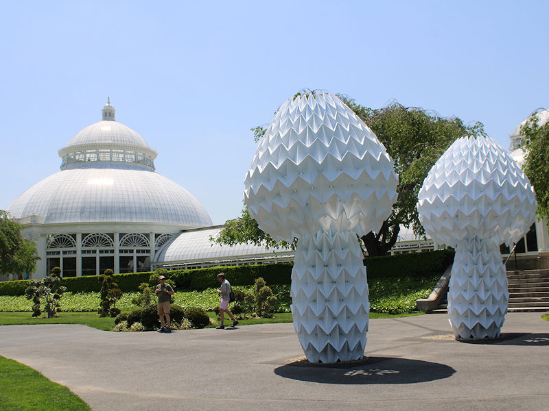
Additional photos from the New York Botanical Garden:

-
A warm weekend lies ahead. Temperatures will top out mainly in the upper 70s and lower 80s. Temperatures will generally remain near or somewhat above normal through the remainder of May. A general 0.50"-1.00" rainfall with locally higher amounts is likely on Memorial Day. The latest summer guidance continues to suggest a warmer to much warmer than normal summer lies ahead. The ENSO Region 1+2 anomaly was -1.1°C and the Region 3.4 anomaly was +0.2°C for the week centered around May 15. For the past six weeks, the ENSO Region 1+2 anomaly has averaged -0.25°C and the ENSO Region 3.4 anomaly has averaged +0.57°C. Neutral conditions are imminent. The SOI was -0.98 yesterday. The preliminary Arctic Oscillation (AO) was +0.277 today. On May 22 the MJO was in Phase 3 at an amplitude of 1.691 (RMM). The May 21-adjusted amplitude was 1.743 (RMM). Based on sensitivity analysis applied to the latest guidance, there is an implied 93% probability that New York City will have a warmer than normal May (1991-2020 normal). May will likely finish with a mean temperature near 65.0° (1.8° above normal).
- 1,603 replies
-
- 2
-
-
-
- spring
- cool temps
- (and 3 more)
-
Temperatures will reach the lower and middle 80s tomorrow. However, the humidity will be lower than it has recently been. Temperatures will generally remain near or somewhat above normal from the weekend through the remainder of May. Periods of rain are likely on Memorial Day. The latest summer guidance continues to suggest a warmer to much warmer than normal summer lies ahead. The ENSO Region 1+2 anomaly was -1.1°C and the Region 3.4 anomaly was +0.2°C for the week centered around May 15. For the past six weeks, the ENSO Region 1+2 anomaly has averaged -0.25°C and the ENSO Region 3.4 anomaly has averaged +0.57°C. Neutral conditions are imminent. The SOI was -0.98 today. The preliminary Arctic Oscillation (AO) was -0.172 today. Based on sensitivity analysis applied to the latest guidance, there is an implied 87% probability that New York City will have a warmer than normal May (1991-2020 normal). May will likely finish with a mean temperature near 64.9° (1.7° above normal).
- 1,603 replies
-
- 1
-
-
- spring
- cool temps
- (and 3 more)
-
Almost certainly many more to come in future years, as the climate continues to warm.
- 1,603 replies
-
- 2
-
-
- spring
- cool temps
- (and 3 more)
-
White Plains picked up 1.53” of rain from a heavy thunderstorm in the past hour. That is its second highest May hourly rainfall and 8th highest all-time.
- 1,603 replies
-
- 6
-
-
- spring
- cool temps
- (and 3 more)
-
Very heavy rain and gusty winds in White Plains. No hail.
- 1,603 replies
-
- 2
-
-
- spring
- cool temps
- (and 3 more)
-
Temperatures will again reach the lower and middle 80s tomorrow and Friday. Some showers or thundershowers are likely tomorrow. Beyond that, temperatures will generally remain near or somewhat above normal through the remainder of May. The latest summer guidance continues to suggest a warmer to much warmer than normal summer lies ahead. The ENSO Region 1+2 anomaly was -1.1°C and the Region 3.4 anomaly was +0.2°C for the week centered around May 15. For the past six weeks, the ENSO Region 1+2 anomaly has averaged -0.25°C and the ENSO Region 3.4 anomaly has averaged +0.57°C. Neutral conditions are imminent. The SOI was -4.04 today. The preliminary Arctic Oscillation (AO) was -0.347 today. Based on sensitivity analysis applied to the latest guidance, there is an implied 88% probability that New York City will have a warmer than normal May (1991-2020 normal). May will likely finish with a mean temperature near 64.9° (1.7° above normal).
- 1,603 replies
-
- 1
-
-
- spring
- cool temps
- (and 3 more)
-
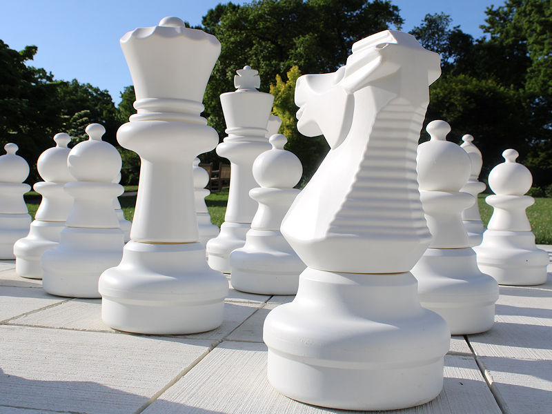
The Cheshire Cat is a costumed character who walks around the Garden during parts of the day. I have not yet run into it.
-
Three more photos:


-
A warming trend continues. The warmth will crest with temperatures peaking in the lower and middle 80s from tomorrow through Friday. Beyond that, temperatures will generally remain near or somewhat above normal through the remainder of May. Meanwhile, parts of Texas could experience their hottest temperatures on record for May during the upcoming weekend. Del Rio, which tied its monthly mark of 109° on May 9th and has had its warmest spring through May 20th by 2.1° could approach or reach 110°. Last summer was historically hot there with that city recording 11 of its 21 110° or hotter days on record. Records go back to December 1905. The latest summer guidance continues to suggest a warmer to much warmer than normal summer lies ahead. The ENSO Region 1+2 anomaly was -1.1°C and the Region 3.4 anomaly was +0.2°C for the week centered around May 15. For the past six weeks, the ENSO Region 1+2 anomaly has averaged -0.25°C and the ENSO Region 3.4 anomaly has averaged +0.57°C. Neutral conditions are imminent. The SOI was +2.24 today. The preliminary Arctic Oscillation (AO) was -0.188 today. Based on sensitivity analysis applied to the latest guidance, there is an implied 81% probability that New York City will have a warmer than normal May (1991-2020 normal). May will likely finish with a mean temperature near 64.6° (1.4° above normal).
- 1,603 replies
-
- 1
-
-
- spring
- cool temps
- (and 3 more)
-
I suspect that it will be the former. Summers during El Niño transitions to La Niña have often featured frequent high maximum and minimum temperatures.
- 1,603 replies
-
- 1
-
-
- spring
- cool temps
- (and 3 more)
-
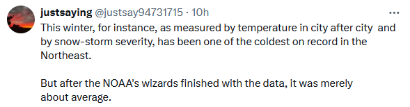
Some are now trying to recast Winter 2023-2024 as "one of the coldest on record" in the Northeastern U.S. In fact, Winter 2023-2024 edged out Winter 2001-2002 as the warmest on record in the Northeast. It was also among the least snowy ones on record. As a result, Boston reached 816 consecutive days without 4" daily snowfall today (old record: 711 days).
-
I will get more pictures in coming weeks.
-
A warming trend is underway. The warmth will crest with temperatures peaking in the lower and perhaps middle 80s during the middle of the week. Beyond that, temperatures will generally remain near or somewhat above normal through the remainder of May. The latest summer guidance continues to suggest a warmer to much warmer than normal summer lies ahead. The ENSO Region 1+2 anomaly was -1.1°C and the Region 3.4 anomaly was +0.2°C for the week centered around May 15. For the past six weeks, the ENSO Region 1+2 anomaly has averaged -0.25°C and the ENSO Region 3.4 anomaly has averaged +0.57°C. Neutral conditions are imminent. The SOI was +9.44 today. The preliminary Arctic Oscillation (AO) was -0.188 today. Based on sensitivity analysis applied to the latest guidance, there is an implied 78% probability that New York City will have a warmer than normal May (1991-2020 normal). May will likely finish with a mean temperature near 64.4° (1.2° above normal).
- 1,603 replies
-
- 2
-
-
- spring
- cool temps
- (and 3 more)
