
DopplerWx
-
Posts
3,398 -
Joined
-
Last visited
Content Type
Profiles
Blogs
Forums
American Weather
Media Demo
Store
Gallery
Everything posted by DopplerWx
-
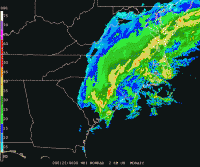
precip looks a bit further north on the gfs out to 69
-
as the 12z nam runs, just look at the northward shift in precip for weds before our event in the last 24hrs.
-
if the 00z euro had a bit more precip northward into nc i think we would have seen a 1-2" system, model just didn't have enough precip to spit out snow at the sfc level even though soundings looked near ideal for snow. would much rather have this issue than our usual fear of the warm nose screwing us. give me cold upper levels and ill worry about precip, especially in this pattern.
-
yep. sickening how it does the little jump above clt. at least i got 2 hours of really nice snowfall rates. hope to cash in on a big one later this winter.
-
Hrrr looks really good for late tonight with the back end. 3k nam showing it too. Hope it can help put down a legit 1-2”’of snow for those of us who got the shaft.
-
Hrrr still looking like a shot at some snow tonight Into tomorrow
-
Latest HRRR much better, nearly all snow for clt to rdu thru the end of the run
-
hrrr looking warmer out to hr18 vs the 12z run.
-
Yea initial rain then all snow until 5-6am or so in clt. 3k looks colder too
-
Brad PanovichVerified account @wxbrad 4m4 minutes ago More I shifted the snow a tad further south due to colder air & a longer duration of snow & sleet, but it still changes to ice Sunday pm. The ice threat keeps going up. #snOMG #cltwx #ncwx #scwx
-
same. moved from rdu to clt and they got 6" last year. even charleston, sc got 5"+. if i moved to Alaska they would likely go snowless and have sleetstorms.
-
soundings much improved for clt. i pray to god it is onto something.
-
we're toast. unless we get 4"+ the fv3 is dead to me.
-
happens every storm and then it trends away from us and snow crushes va and the mtns.
-
if we get frz rain rates will be heavy and temps marginal. these 1:1 frz rain maps likely won't even come close to verifying.
-
massive warm nose by hr 34 on the 3k nam in clt.
-
by hr 30 clt looks to be a snow sounding but it is very close. i think a lot of these shifts in rain/sleet/snow line is from the varying precip rates with each run moving north and south.
-
temps much warmer at 45 than 12z though. a lot of frz rain and sleet.
-
nam trends over the past 6 runs, temps cooler, precip slower.
.thumb.gif.c634ebddfe4be7886349abccf2fc6025.gif)
-
at 36 its pretty close to 12z, snow line may even be a bit south. precip just was slower.
-
18z run of the hrrr goes out to 36hr and is still running but i figured i would post it. shows rain but soundings have 2m temps at 46 (5 degrees higher than the forecast) so hopefully out to lunch.
-
yea are the WRFs worth anything this far out?
-
euro kuchera maps brought the snow line a tick north but nothing huge. 4-6" for clt on the front end snow before changeover.
-
fv3 holds serve, pretty close to 06z
-
12z nam with a mized bag. total snow increased a good bit each run since the 12z runs yesterday which is a good trend.


.gif.cec354eb2e06dc7deb2e67f4607ece96.gif)
