

frd
-
Posts
6,468 -
Joined
-
Last visited
Content Type
Profiles
Blogs
Forums
American Weather
Media Demo
Store
Gallery
Everything posted by frd
-
For those desiring a weaker early season PV. and this ........
-
HM was talking about the IOD, and wow to this spike up.
-
With the IOD at records highs it is one of the main drivers currently . The UKMET keeps it positive all winter. Although it does decline in time. Makes you wonder whether the impact of it can indeed produce an early winter arrival this year.
-
From a simply persistence point of view, you would have to think the boring and dry period we are having would likely reverse in time, and hopefully coincides with the colder months ahead.
-
Wonder if maybe the advance posting of the Watch is related to the wording, given the focus on the possible extreme severity of the storm's potential and the wording about setting a new benchmark. Of note to campers and hunters maybe getting caught off guard. Pretty crazy wording ! Extreme impacts possible, including to power infrastructure including power lines resulting in widespread power outages, agricultural interests; outdoor recreational interests including camping and hunting activities; and travel. Widespread significant tree damage is possible with heavy wet snow and strong winds impacting trees with foliage. * ADDITIONAL DETAILS...This early-season winter storm and/or blizzard has the potential to set a new benchmark for snow accumulations, cold temperature
-
Hoping the QBO continues its decline, seems it may have stalled out in September, possibly related to the SH SSWE and the BDO. Something like this happened before and it then resumed its decline by year end. However, this is a negative at this time, and it really needs to resume its decline to have an effect for the upcoming winter. Some additional comments within this post griteater @griteater Sep 18e The transition from + to - QBO is dropping from the upper stratosphere toward the middle stratosphere. It needs to drop quickly now in order to classify the upcoming winter as -QBO (to go along with the low solar) griteater @griteater Sep 18 More It could be on delay yes, but there’s still a bit of time for it to drop sharply to end the year. In theory, it would be better for winter blocking if it drops sharply (with solar min) 1 reply0 retweets3 likes
-
The Siberian High off to a good start .
-
Decent Met read looking at the upcoming winter. Courtesy 33andrain OHweather Member Meteorologist 164 36 posts Location: Hackettstown, NJ Posted September 13 Playing with some analogs right now...here are some analogs, discussion, and caveats, focused mainly on the U.S....FWIW, my temp map for work is not as cold as this analog composite would imply and allows some risk for a SE ridge to crop up should things trend too far in the wrong direction (read below). Here are my key assumptions when looking for analogs right now...the analogs used to compile the attached 500mb map were found by subjectively rating every possible analog on each of the following criteria. Ultimately I give ENSO, PDO and QBO the most weight along with the solar cycle, though all of these are considered. ENSO: Neutral, though can allow for weak El Nino or weak La Nina if the year featured warmer waters near the dateline. Extra preference if coming off of a weak or moderate El Nino the prior winter-spring. PDO: Neutral or positive (it's positive right now though not strongly) QBO: Positive trending negative, expecting the 30mb winds to flip to negative at some point in the early to mid-winter Solar: Minimum Indian Ocean: Positive IOD in the fall, can trend downwards during the winter Off-equator Pacific SSTs: A positive to strong positive PMM (it's very positive right now), with more weight given if it stays positive through winter Atlantic: Neutral or positive AMO (it is positive right now though not strongly) Tried to find matches based on similar tropical forcing in mid-late summer as this year, though not as strong of a weight. Tried to find matches based on years with significant spring/summer high-latitude blocking, though was not as strong of a weight. The analogs I went with for this exercise are...1958-59, 1966-67, 1969-70, 1978-79, 1980-81, 1985-86, 1990-91, 1993-94, 1995-96*, 2003-04, 2004-05*, 2013-14*, 2014-15, 2017-18. Stars denote highest scoring matches when considering all of the above and double weighting. Obviously some of these are very cold winters for the eastern U.S. and the composite look is cold. There is a strong signal for Alaskan ridging and a -EPO, which is not a warm pattern for the central and eastern U.S., though where exactly the cold dives in can make a difference for the eastern U.S. with more mixed signals on an NAO. A neutral-ish ENSO and +QBO to start winter aren't great signals for a -NAO, though the deep solar min is and the QBO will be improving through the winter. The SSTs up there support a -NAO, but aren't a strong forcing mechanism on their own. There is not a strong correlation between negative summertime NAO and subsequent winter NAO and the forcing mechanisms are different, so the persistent -NAO this summer doesn't really help or hurt. In terms of what to watch for in the eastern U.S. in terms of swinging warmer or locking in cold...I'll be watching to see if we hang on to the warm waters near the Dateline in the Equitorial Pacific and the +IOD as we head into fall. If we keep those we are more likely to see convection near the Dateline this winter which usually forces an Alaskan/western Canadian ridge. If we see a stronger push towards La Nina and lose the warmth near the Dateline, the risk for a more amped SE U.S. ridge increases...we don't need the Nino region 3.4 anomaly to be above 0C to have a cold winter in the east, but region 4 is pretty important and needs to stay warmer IMO. Based on the persistent -SOI and forecast generally weak trades over the central and western Pacific over the next week or so, there won't be a big La Nina push in the near-term, though the recent easterly trade surge did nudge things in that direction over the last couple of weeks and there's still a lot of time for that to resume. The waters near the Dateline and just west remain fairly warm both at and below the surface, and until that goes away some move back towards a weak Modoki El Nino also can't be ruled out. As we saw last winter, a SSW can really enhance tropical forcing/convection over the West Pac warm pool (which is usually warm for the eastern U.S.), so an initially +QBO and seemingly low risk for an early SSW may give some margin for error...but if the SST pattern becomes unfavorable between Australia and S. America for convection near the Dateline the pattern more likely supports eastern U.S. warmth this winter. The analogs that have an Aleutian low in October generally had much colder subsequent winters than the ones that have an Aleutian high and subsequent trough over western Canada in October. I'm aware of what the longer range guidance hints at to start October up there, but wouldn't lock it in yet. A continued drop of the QBO heading into the fall is also important for increased high-latitude blocking prospects as we head into winter and a lower risk for the Pacific jet to be too strong/zonal into the west coast, which would likely result in quite a bit of warmth for North America given how mild the entire Pacific is. An additional caveat is the northern hemisphere water temperatures from the tropics up to the polar regions where there was another near-record sea ice melt are ON FIRE. Do older analogs break down as we continue to warm? If so, how do things change? The warming baseline gives less margin for error (you probably don't luck into below-average or even average temps, you either have cold signals or you torch). Lots of food for thought...I definitely don't hate the prospects for a snowy winter from the Ohio Valley and Great Lakes into the Northeast, and the warm PMM and any remaining warm ENSO influence can bring some snow prospects to the mountains out west, but the pattern can turn warm quickly if we lose the warm equatorial waters closer to the Dateline.
-
Certainly I can see this as a big player, ( Arctic warming, but also how computer modeling is really struggling with winter seasonal outlooks ) . It has been a NH Russian Roulette the last few years. Our region was not lucky but memorable severe snow and cold hit many cities during the winter. So many players on the field, and you have to think extremes are the new normal. https://buffalonews.com/2019/09/18/climate-change-likely-to-throw-wrench-into-winter-outlooks/
-
Take with a grain of salt, but snow cover to the North builds through October despite the lower 48 very warmish. Can't hurt.
-
interesting post from bluewave here it is worth a mention ..... <<<< 10 hours ago, bluewave said: Looks like the more active MJO is shifting us back to a warmer pattern for the rest of September. Much more Niña-like pattern with the big ridge building north of Hawaii. So we are shifting away from the big Canadian high pattern that has dominated since August. Going forward we have to monitor the ridging north of Hawaii. That was one of the factors that spoiled last winter. If this ridge becomes more established north of Hawaii, then that record warm SST blob could shift west with it. Probably too early to know for winter. But just something to monitor going forward. >>>>>
-
If you believe his hype and so-called proof it really doesn't matter one way or another, but I still feel it is much better to have a decent cryosphere. I personally don't weight the SAI but I do like to see a lot of snow up North. Last year started great, and then as many of you remember, we lost huge amounts of NA snow cover after the excellent start. I still prefer to see it snow covered than not up North. So that's the reason for this post. A decent start so far.
-
I like this very much and could help us here. Maybe forcing will be dateline centered, while the Eastern Pac cools off.
-
Yes, nice read ( his break down is very detailed ) and the QBO is favoring us, as others have said as well, including Mitchnick as well. Wonder if the winter comes on like a rubber band snapping back, with a sudden change to cold. Seems Ray implies at the end of his outlook a colder and drier scenario, but mentions above normal precip along the East Coast. If anything seems that the SH may provide a clue as well. And for us here in the NH as we get deeper into the cold season wonder about the effects on our PV from various factors.
-
Meanwhile Alaska is melting ....... below ground perma frost is thawing quickly. More records set this month there in terms of high temps. And the waters to the West and SW are very warm.
-
A further look at the seasonal
-
I hate seasonal models but if you want a feeling this far out it looks pretty grim for snow in the Mid Atlantic. Seems the general atmospheric set up portrayed by the various models and super model blends look to favor a Western Winter and cold and snowy up in the Great Plains. Maybe the continued tendency for a warmer climate is making it harder and harder for winters to deliver below 40 North. A warm snow-less winter in these parts would not surprise me, nor would a complete failure of the models leading to a more traditional cold and snowier winter in the East.
-
Some cool info on the warm blob. The article is not hyping , but just bringing up some comparisons and why the warm blob may simply fizzle away. https://www.forbes.com/sites/allenelizabeth/2019/09/05/another-warm-blob-is-forming-in-the-pacific-ocean/#78dc8d9a14af
-
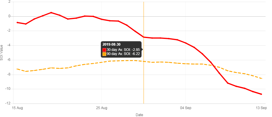
Nice to see, regardless of outcome at this time of year.
-
Dive continues 30 day Av. SOI 90 day Av. SOI Daily contribution Date Tahiti (hPa) Darwin (hPa) Daily Contribution 30 day Av. SOI 90 day Av. SOI 13 Sep 2019 1013.56 1016.10 -28.88 -10.70 -8.55 12 Sep 2019 1014.46 1016.25 -24.42 -10.34 -8.18 11 Sep 2019 1015.25 1014.90 -11.70 -9.91 -7.91 10 Sep 2019 1014.70 1014.25 -11.11 -9.63 -7.72 9 Sep 2019 1013.50 1014.80 -21.51 -9.19 -7.49 8 Sep 2019 1013.95 1015.15 -20.92 -7.80 -7.03 7 Sep 2019 1014.10 1014.35 -15.27 -6.34 -6.71 6 Sep 2019 1014.09 1013.55 -10.58 -5.17 -6.55 5 Sep 2019 1013.81 1013.60 -12.54 -4.27 -6.55 4 Sep 2019 1013.73 1013.90 -14.79 -3.66 -6.54 3 Sep 2019 1013.36 1013.85 -16.70 -3.23 -6.43 2 Sep 2019 1012.96 1014.15 -20.86 -3.06 -6.33 1 Sep 2019 1013.31 1013.40 -14.32 -2.99 -6.29 31 Aug 2019 1013.01 1013.35 -11.90 -3.00 -6.32 30 Aug 2019 1012.61 1014.40 -20.70 -2.85 -6.22 29 Aug 2019 1014.44 1015.30 -15.05 -2.05 -6.07 28 Aug 2019 1015.17 1014.90 -8.19 -1.22 -6.10 27 Aug 2019 1015.16 1013.85 -1.88 -0.64 -6.12 26 Aug 2019 1014.85 1013.20 0.18 -0.61 -6.17 25 Aug 2019 1014.30 1013.55 -5.28 -0.40 -6.33 24 Aug 2019 1015.25 1014.80 -7.10 -0.03 -6.48
-
Rather quiet ......... not sure I believe the CM predictions.
-
The warm pool near the date line as modeled supports this, so no surprise there.
-
More to come......
-
Will be interesting to see if we can buckle or slow the Pac jet this Winter and late Fall. Last winter several records were broken in regards to the West to East jet stream speed. Even happened in the spring as well.
-
@C.A.P.E.this I was unaware of, each model has its own bias when it comes to the forecasts of the early PV . Some go strong and cold , others weak and not as cold. Also, each model has inherent noise and this needs to be taken into account as well.


