Boreal
-
Posts
427 -
Joined
-
Last visited
Content Type
Profiles
Blogs
Forums
American Weather
Media Demo
Store
Gallery
Everything posted by Boreal
-
Central PA Winter 25/26 Discussion and Obs
Boreal replied to MAG5035's topic in Upstate New York/Pennsylvania
Bangor PA. Still some light snow here but barely hanging on as it’s 35°. -
Central PA Winter 25/26 Discussion and Obs
Boreal replied to MAG5035's topic in Upstate New York/Pennsylvania
Bangor PA. 33° Light snow. 0.25” but mostly melted now. -
Bangor PA 26° light snow. 0.5”
-
Central PA Winter 25/26 Discussion and Obs
Boreal replied to MAG5035's topic in Upstate New York/Pennsylvania
Interesting snippet from Binghamton NWS AFD (issued prior to the 12z runs) Of particular note is the colder trend in the model guidance for Friday with the surface low track trending further to the south and a high to the north supplying colder air to the region. Should this trend continue, temperatures on Friday would be much colder than previously expected, with upper 20s to mid 30s for highs, rather than upper 30s to near 50 degrees for highs. In fact, the change from the 01Z NBM to the 07Z NBM shows this exact drastic difference. This would also mean snowier scenario for Friday, rather than a wintry mix to rain scenario. This will continue to be closely monitored with our upcoming forecast packages. -
Central PA Winter 25/26 Discussion and Obs
Boreal replied to MAG5035's topic in Upstate New York/Pennsylvania
Bangor PA. 29° Moderate Snow. Back edge approaching up here. Over 5” now. -
Central PA Winter 25/26 Discussion and Obs
Boreal replied to MAG5035's topic in Upstate New York/Pennsylvania
Bangor PA. 32° Snow. 1.5” -
Central PA Winter 25/26 Discussion and Obs
Boreal replied to MAG5035's topic in Upstate New York/Pennsylvania
Bangor PA. 33° snow, 0.5” -
Central PA Fall Discussions and Obs
Boreal replied to ChescoWx's topic in Upstate New York/Pennsylvania
Infinitesimal flurries. 21° -
Central PA Fall Discussions and Obs
Boreal replied to ChescoWx's topic in Upstate New York/Pennsylvania
Tempest -
Central PA Fall Discussions and Obs
Boreal replied to ChescoWx's topic in Upstate New York/Pennsylvania
Well - like many, it started out as 4-6, and was gradually reduced to 1-2 (per NWS). Decent, quick event. -
Central PA Fall Discussions and Obs
Boreal replied to ChescoWx's topic in Upstate New York/Pennsylvania
Just crept above 32°. Ended with 3.0” here in Bangor PA (far northeastern Northampton County). (I prefer to post here vs. NY / Philly forums because it’s always been a generally better vibe) -
Central PA Fall Discussions and Obs
Boreal replied to ChescoWx's topic in Upstate New York/Pennsylvania
Bangor PA. 29°, SN , 1.50” as of 10 AM -
Central PA Fall Discussions and Obs
Boreal replied to ChescoWx's topic in Upstate New York/Pennsylvania
Bangor PA: Temp 26°/ Dew Pt 19° -
Bangor Pa - 30.7° Light snow 3.1” on the ground
-
Bangor Pa - 30.7°/27.3° flurries (coating)
-
Far to the east in Bangor PA (elev. 675’) 33.6° T / 31.3 D with steady snow
-
Looks like sleet/zr is impacting NAM totals particularly in MD/LSV. It will be telling how long the snow holds on down your way. PS: appreciate all the reports from this group.
-
Bangor PA 28.6°/27.1° Moderate Snow 4.75”
-
Keep it up. Much appreciated.
-
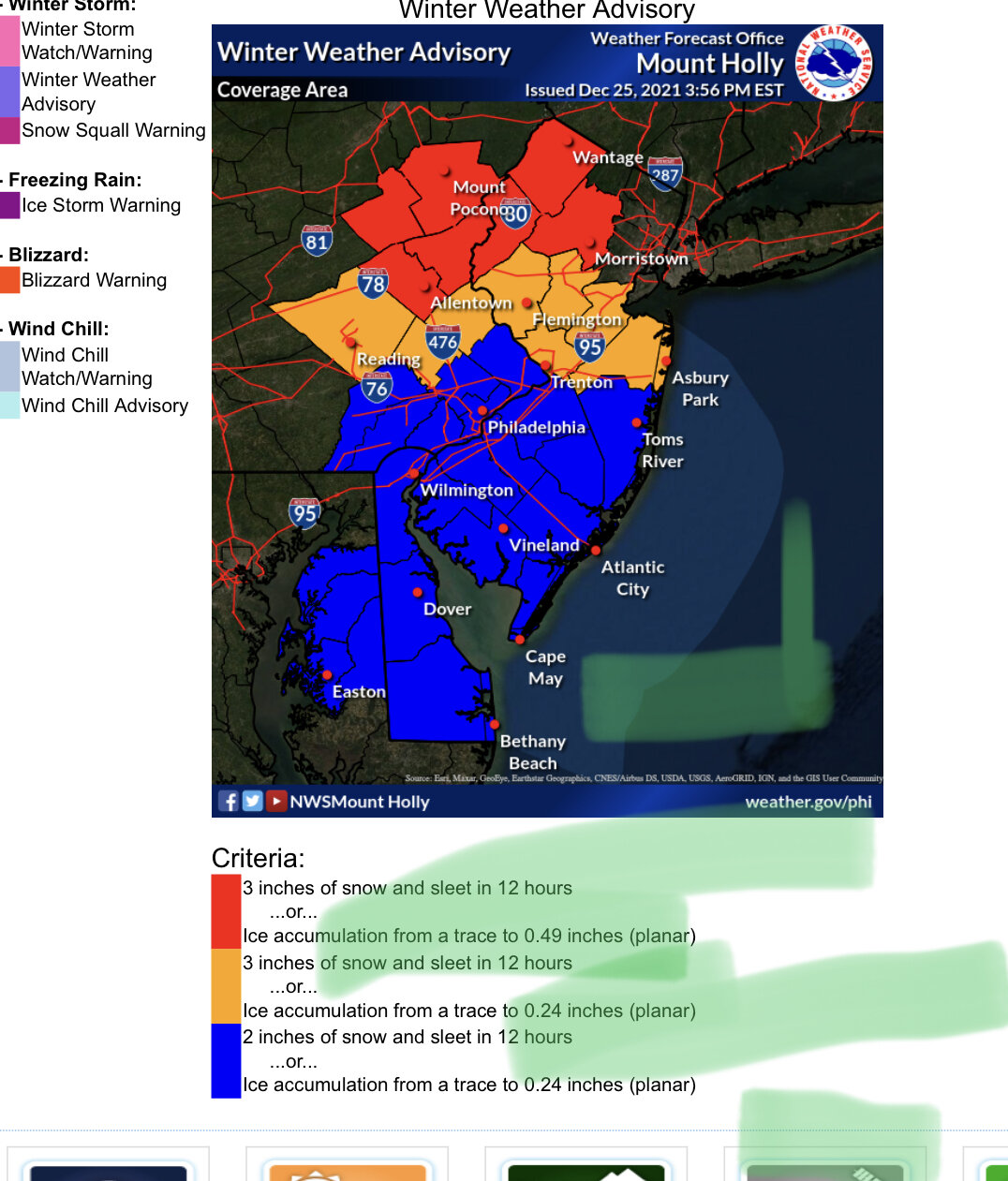
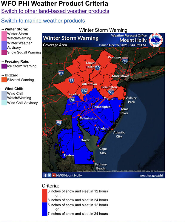
So true that Rt 78 is always a mess in any weather, especially Lehigh-Berks portion. Per the latest AFD Mt. Holly seems to be aware of the potential for some increased snow totals in the NW 1/3 of the forecast area: “…My current feeling is that totals on the coast may be a little on the high side given a potential positive snow-ratio forecast bias, but may be a little on the low side in the northwest CWA (where snow ratios may be higher, and where forecasts have trended west with QPF in recent model suites).…”. Today’s snow has been in the forecast for many forecast cycles, but it’s far too little to warrant an advisory, and also may be too far removed from the potential additional snowfall tomorrow to even get the area to advisory level snows (the NWS criteria is 3” in 12 hours). I am more frustrated seeing the potential big snows to the east than by anything else, but hopefully some of the modeled snow trends continue and we get to join the party.

-
January 31-February 2, 2021 Major Winter Storm Observations
Boreal replied to Ralph Wiggum's topic in Philadelphia Region
In a long duration event like this one, melting, sublimation, wind and compaction ongoing during the event can help maintain a decent disparity between snow depth and total snowfall. Personally, I am not a trained spotter, but I am a vigilant and am fairly precise while attempting to follow the NWS guidelines for snow measurement. I am long time winter weather enthusiast and strive to maintain accurate records for posterity. Interestingly enough, my personal experience in this storm sounds very similar to what you described above. I measured a storm total of 30.3” at my location. I later learned that a trained spotter from the same municipality reported 30.5” from the event. I also happened to record a time lapse video for the duration of the event, focused on my snow stake which shows 1 inch increments up to 24”. The snow depth at the stake never quite made it to 22”. While there may be some exaggeration out there and even intentional misrepresentation of snowfall figures, I think most folks on this and similar forums do an honorable job in reporting their totals.