WxUSAF
-
Posts
28,452 -
Joined
-
Last visited
Content Type
Profiles
Blogs
Forums
American Weather
Media Demo
Store
Gallery
Everything posted by WxUSAF
-
Can you please post much less? Thanks!
-
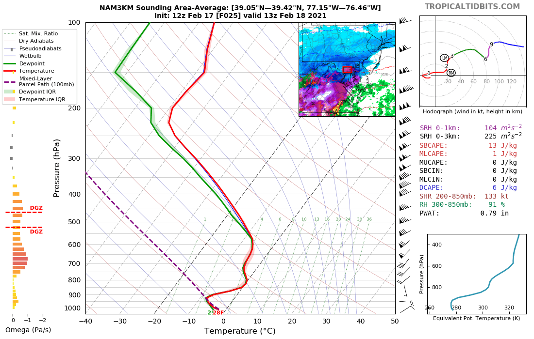
Interestingly (?) the NAM has dramatically reduced the 700mb warm layer that was showing up yesterday. Look at the difference between 12z yesterday and today for my area. Warm layer now is 800-850mb, which was also present yesterday. Eventually, the 700mb warm layer does punch in, but several hours slower than shown previously.

-
Just keep in mind that the Super Bowl storm showed the I-95 corridor being the precip max right up until the start. Meso bands are not well predicted ahead of time.
-
I hate that little blue blob right over my house surrounded by yellow. But can’t say it’s wrong. Every major storm this winter has basically been 3-4” of snow plus mixing. Don’t see a reason to change that for tomorrow.
-
Post mortems before the storm is over are weird, but I’ll say this. The NAM held onto the OH valley primary idea way longer then other guidance. That’s a big part of that reason it was showing so much more mixing than the globals in the last 48hrs. That certainly looks like it’s going to be wrong. Now there seems to be decent agreement with the mesos and the globals on track and the slight differences are due to location and strength of the warm layer aloft.
-
I can’t decide which is worse: 10:1 snow maps that include sleet or snow depth maps that must be based on measuring on top of your running car’s hood.
-
Still seems aggressive at this point but whatevs. I’m fully expecting tomorrow to be Rug Pull: Episode V, Revenge of the NAM.
-
Thankfully the RPM jackpots me so I’m hugging
-
Dew point has dropped over 20F!
-
I like it for our backyards. Sleet line gets so close I'd probably be able to hear it.
-
I'll feel comfortable with the 6z Thursday runs. Thankfully, I'll be asleep when they come out so oh well.
-
Snow's all going to melt before April
-
For sure, especially this year. But we're ~36 hours out and still moving the right direction so far.
-
The claw in precip total may be real, but you can really ignore the snow maps here. St. Mary's County isn't getting 14" of snow while Baltimore gets 8-10".
-
Almost as cold as the Euro and wetter. Dang son.
-
850mb clearly colder on 18z vs 12z. Not a ton, but noticeable shift toward colder/SE solution. 700mb pretty much a wash across the region compared to 12z.
-
With that initial WAA band pre-dawn Thursday, we get an extra 2-4", then another ~1" of snow, and then the sleet bomb (maybe 1-2" of sleet?). I'd take that verbatim.
-
SLEET PARTY
-
That initial WAA snowband on the 3k NAM was well into PA on 12z and now is just north of DC into MD with the 18z run.
-
Didn’t realize it was so recent.
-
For sure. I expect that’s overdone, but teens for lows seems likely.
-
Weird echo in here
-
Euro says single digits for everyone outside the city centers Sunday morning.
-
700 colder than 0z also. Still trending the right direction on euro at least with <48hrs to go.
-
It’s a pretty weenie run for MD north of DC. Probably all snow or nearly all snow.