WxUSAF
-
Posts
28,700 -
Joined
-
Last visited
Content Type
Profiles
Blogs
Forums
American Weather
Media Demo
Store
Gallery
Everything posted by WxUSAF
-
My kids say there's ice on the trees and what happens if one of those branches falls on a kid walking to school?!? Thoughts on that dangerous situation, @mattie g?? Shame on HoCo schools for not closing
-
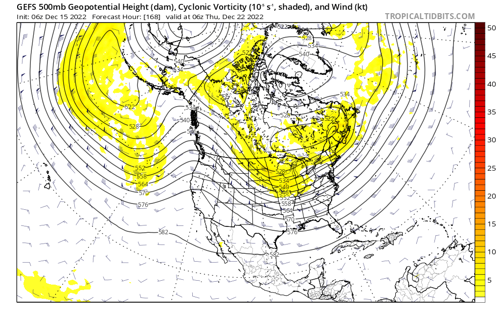
Ensembles work by perturbing the intensity and location of features to account for errors and uncertainty. At D7-8, it’s perfectly normal to have a much broader area of low pressure than what will ultimately occur. Plus, always be a little more skeptical when a model suite’s solutions are playing up its biases: 1. Progressive bias for GFS 2. over amplified bias for Euro 3. wonky 2m temps for GGEM
-
Hot damn. This checks all the boxes for big east coast winter storm. Elongated PV toward the 50-50 region? Check. -NAO in Baffin Island region? Check. -AO? —-AO! +PNA with inland ridge axis? Check. Big shortwave diving south? Check.

-
We’ve definitely gotten nice trends on the Atlantic side the last 24 hours or so. More mixed out west it seems. I’d love for that ULL to dig for Memphis, but haven’t seen any sign of that. Still time for large changes.
-
Impressive precip signal too
-
#CAPEStorm2022
-
The last few cycles have left that shortwave up in the Yukon, which is cutting off our PNA ridge. Not sure entirely what that entails for us or what we’d want… taller PNA ridge would help our storm dig farther south.
-
It was *this* close to producing a massive Miller B early on the 24th.
-
We get a dusting! No taint!
-
Hopefully if the 23rd fails, by the time we know that we'll be already busy tracking something for after the holiday
-
An all coastal storm scenario looks pretty unlikely at this moment, but I'd also lean against a pure cutter. So I think some sort of redeveloper scenario like the Op runs today portray makes the most sense. But there's a pretty huge range of options in there in terms of sensible outcomes for us. Good news is that I think we get *some* snow in most of those redeveloper scenarios, but that could range from a dusting-2" with the arctic front to a MECS/HECS.
-
You're correct. If this sort of redeveloper scenario ends up happening, it all depends on where the energy transfer occurs and how strong the Lakes low will be as that's happening. If you look closely, GGEM and Euro have a little snow from the coastal at the start today, then quick change to rain, then snow with the arctic front. Very complicated and lots of subtle details. For now, we want the strong shortwave to enter the Plains farther east and dig farther south.
-
That single person who lives in San Diego and likes winter will be disappointed
-
Massive improvements on the euro vs last 2 runs. Couple more similar shifts and we're in business
-
Trough near Hawaii and that Aleutian low are very Nino-like and should keep things pretty active.
-
Low of 21 at BWI. Solid.
-
0z GFS is not the 12z GGEM precisely, but it’s the upper end advisory/low end warning version. All snow, no taint.
-
Much more of a coastal-dominant lean on the 18z GEFS vs 12z

-
That event had an unexpected mesoscale low form along the front which produced that boom in snow totals. I think what the gfs just spit out would be way more dynamic synoptically.
-
That’s wild. And that snow along the arctic front on the GFS is “real” and not an illusion like sometimes happens on the backside of storms on certain plots.
-
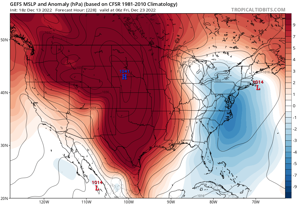
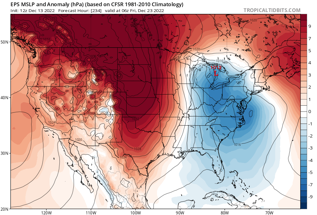
This is some useful info from the EPS I found on Twitter just now. Here’s the MSLP anomaly next Friday. And this shows MEDIAN temp departure at the same time. Median avoids outliers, which in this case would be the Op on the warm end and perhaps earlier passing storms on the cold side. Temps in the teens…

-
@psuhoffman, maybe a lot again comes back to what people mean for “cash in.” I know some are HECS or bust. I’m not and maybe that’s my befuddlement. I’ve said a few times that something like 3” for DCA and ~6” for IAD and BWI would be wins in my book for December. That’s like 200% of normal! And if that comes via a front end thump that eventually mixes or changes over and then is followed by arctic air…bring it on I say.
-
^That 987mb off Wallops Island would be acceptable I think.
-
Looks disastrous. Better pack it up and maybe we get lucky in March before spring arrives for good.
-
As I said earlier, the Op runs have been wanting to phase in the PV and make it dig deep in the Rockies over the last day or two. Not sure why, but the ensemble means want nothing to do with that. If that dichotomy continues through ~Sunday, then I'll start to get mildly concerned.