

WxUSAF
-
Posts
24,680 -
Joined
-
Last visited
Content Type
Profiles
Blogs
Forums
American Weather
Media Demo
Store
Gallery
Posts posted by WxUSAF
-
-
Snowing in Columbia now enough that normies would notice. My PWS at 32.7.
-
 2
2
-
-
A few tiny flakes with mist
-
Starting to mist again in Columbia. Don’t hate the radar…just needs to get here.
-
1
-
-
Temp down to 34. Tough call for schools. Dry slot going to mean the heaviest snow will be as busses start after the 2hr delay…
-
1
-
-
Asked my parents in Bel Air if it’s snowing yet. They respond “not yet, dusting on the mulch and street covered”


-
 8
8
-
-
@wxmvpete already reporting 1” of snow northeast of Westminster
-
1
-
-
1 minute ago, nw baltimore wx said:
The dryslot is a bummer but there’s precip redeveloping to the southwest and with the pivot, I think there still could be a few hours of good snows this morning.
Yeah I think it’s still coming. We’ll see how much accumulation happens.
-
2
-
-
Just now, Scraff said:
#Ifonlyitwasprecipitating
Yeah that too…
-
Been awhile since I’ve seen a pivot on radar like this #ifonlyitwascolder
-
1
-
-
7 hours ago, psuhoffman said:
Strongest signal it’s had yet.
0z more of a cutter look booooo
-
Would have guessed over 1” of rain with how loud it was overnight, but actually only about 0.65”. Temp is 35.6 here in the dryslot.
-
Ok f it. Hugging the hrrr and going down with the ship. Gonna stop looking at guidance so I’m not disappointed until I wake up in the morning lol
-
7
-
-
EPS looked decent for the PSU storm


-
7
-
 1
1
-
-
Temp plummeting. 43/41. At this rate should be in the low 20s by morning
-
 3
3
-
-
10 minutes ago, aldie 22 said:
It's raining

And it’s in the 40s! Bust incoming?
-
6
-
 1
1
-
-
Just now, StormyClearweather said:
Ahem

Weenies should drive in the westbound lanes on the north side of 495. All rain for eastbound losers.
-
2
-
17
-
-
1 minute ago, high risk said:
Goddamnit, y'all. I have literally worked as a RAP/HRRR developer, and I would still use the JMA or NAVGEM before I used the RAP/HRRR system for snow amounts.
")
Think the ratios are too low at 10:1???
-
14
-
-
3 minutes ago, rjvanals said:
My concern w the storm is we’re counting on dynamics to get us cold enough for a marginal snow event from a system that’s been weaker than modeled over the past 24 hours
Putting aside my weenie bun, this is a very good point
-
1
-
-
3 minutes ago, WVclimo said:
This seems like the perfect setup for you to get the jackpot in our region. Hope you get pasted.
I think @mappy is in a real good spot for this a bit farther east
-
1
-
-
Channeling @Deck Pic
48/43 excited for my snowstorm
-
3
-
9
-
-
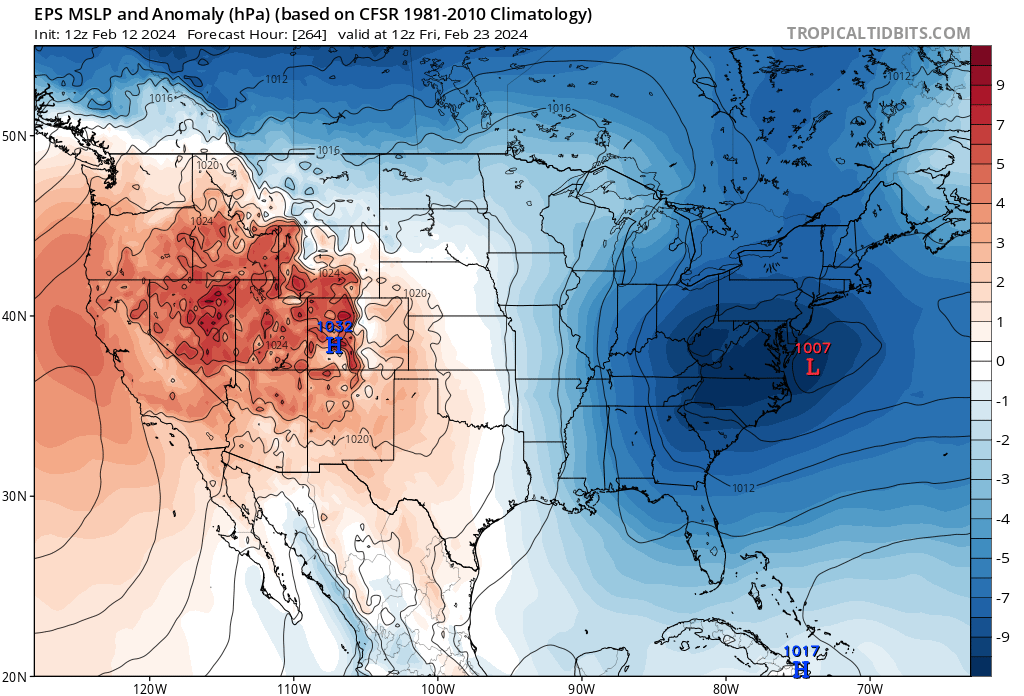
29 minutes ago, Ji said:
eps must not of been horrible for next week
.thumb.png.e6ff08650a79becca5b0842e9cf8eec6.png)
Nice. Still a lot of members with more snow after tomorrow.
-
2
-
-
27 minutes ago, Ji said:
i just dont understand what happened....
Mostly it seems we don’t have a huge 4SD retrograding -NAO anymore. The pattern this upcoming weekend and through the following week still looks “decent/workable/fine”. Some periodic +PNA, continuing -AO…it’s not a bad pattern by any means! Just doesn’t look epic anymore.
-
4
-
-
17 minutes ago, ORH_wxman said:
This is one of the worst modeled systems i can remember in the past 10-15 years. Guidance has been really bad with this. Reminds me a little of the 1/27/11 event in that respect, but that one actually started coming back in the final 12 hours....this one better reverse course soon if it wants to match that progression.
Not sure what all your perspectives may be, but one of my takeaways for this entire winter has been that the northern stream has been way more involved than I expected. With a strong Nino I was figuring we’d have some number of big honking southern lows and the only question would be how cold it was and where. But for the most part the southern lows have gotten bullied around and that looks to continue the next 7-14 days with our previously classic Nino pattern.
-
1
-
-
7 minutes ago, Maestrobjwa said:
I don't get what's going on with this window in general...I mean is that the ceiling of potential here, or is this just one part of it? Sucks seeing all that moisture getting suppressed on these runs...although seems a bit less suppressed this time. I wonder what would happen if the ns wave were to slow down and dive in behind instead of going on top or ahead. Complicated setup?
I think there’s been potential for phasing the entire time with this, but outside of a few random op runs, there hasn’t been much support for it. Mostly guidance has suggested that in some way the northern stream squashes the southern wave. For now seems our best chance for snow is with the northern shortwave alone. Honestly it’s not much different than the second storm of our January week of winter. Can we get another short range favorable trend??
-
1
-
.png.8da0ecf89fe00cfee76a136a6e787be2.png)
2024 Valentines Day Who the Hell Knows - Comeback Thread
in Mid Atlantic
Posted
Measured 0.2” of slush on the snowboard. Should add more. Temps ended up being not a major issue for us at least.