

EasternLI
-
Posts
3,361 -
Joined
-
Last visited
Content Type
Profiles
Blogs
Forums
American Weather
Media Demo
Store
Gallery
Posts posted by EasternLI
-
-
Something funky about this year. I've been saying since November. Just peeking at the extended 00z eps. The look from the 12z yesterday has held serve.
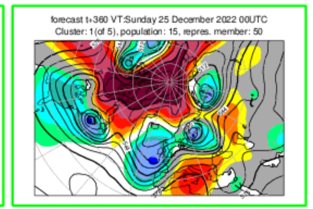
What raised an eyebrow for me is this curious little move on the cluster analysis. Check out the arctic profile on last night's leading cluster. That was the 2nd place cluster on yesterday's run. So last night it takes the lead? Thought that was a bit interesting. They're centered on Europe, so rotate your screen accordingly. (Green border just means -NAO profile)
.thumb.png.86a74894791e0118ea8f1a567b1b61d5.png)

-
 2
2
-
-
37 minutes ago, MJO812 said:
Eps is full of winter
Arctic outbreak look. Cross polar flow on this.
.thumb.png.bd34c6ae6fe1b3a4bc3517076dd88534.png)
-
3
-
-
34 minutes ago, Volcanic Winter said:
@EasternLI about to get arrested for aggravated assault on the SPV.
I’ll bail you out brother.
Appreciate it. I'm in position with the brass knuckles.

-
1
-
 2
2
-
-
7 hours ago, bkviking said:
Please say clearly your thoughts
I'm increasingly thinking we're heading right for the -AO winter scenario. The vortex is in rough shape. Certainly not strengthening rapidly like it should be at this time of year. In addition, the tropical looks are starting to resemble phase 6, if not phase 7. That's according to both gefs and eps this morning at the end of those runs. This would also be a very bad development for the vortex. Precursors have also displayed themselves this season already. The Urals blocking is an example of that. There's signs pointing towards this outcome, and we haven't deviated from that path. If anything, we're further along that path in my eyes.
-
1
-
-
-
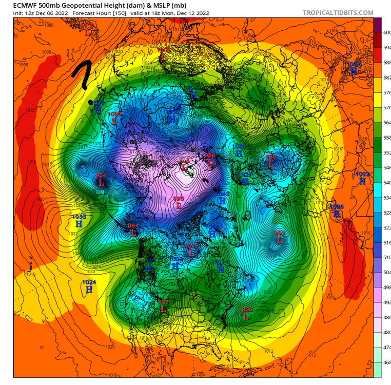
Look at the tilt through the vertical column. That is not good, bordering on terrible for the vortex. It's been having a bad year with no signs of stopping.
.thumb.png.85b2fdd06883fab0b8d73c5fd0f04003.png)
.thumb.png.6c432796c2cb55e06d5b11f5b0584a1c.png)
-
2
-
-
It's not a happy PV on guidance I'm seeing either. It's still up and running, but doing so with 2 black eyes and a broken arm at the end of most runs. Not only that, but increasingly. Definitely interested.
-
1
-
-
5 minutes ago, EastonSN+ said:
AO region is completely different. PV was over Canada. We do have a neg AO though so could be very interesting.
Took a little exotic maneuvering, but we're making progress again.

-
2
-
3
-
-
Eps was not interested in 92W at all originally. Now caving to the GEFS. I think what ultimately happens with this feature will be important.
-
2
-
-
2 hours ago, Allsnow said:
This -epo really popped the last few days on the ensembles. Looks like more of a 14/15 type pattern now
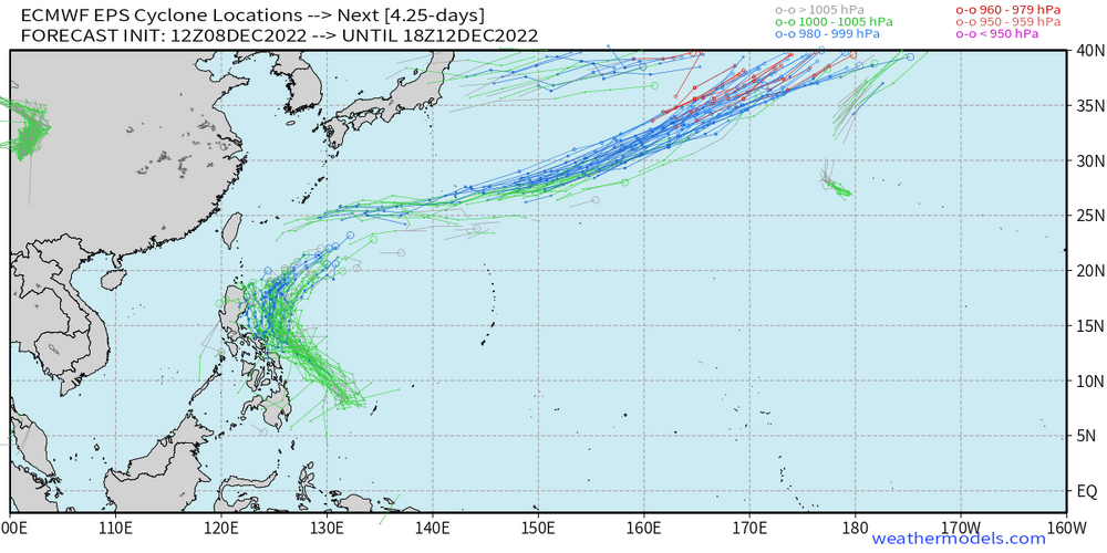
Yeah, I think 92W is giving a boost there. It really only popped up on modeling a few days ago. Then started trending to recurving to get mixed up in the Pacific Jet. I think this explains how the EPO snuck up on guidance.
.thumb.png.beb64fb783812094832f4912ac4523be.png)
-
2
-
-
5 minutes ago, EastonSN+ said:
I am pretty confident of a 6 to 12 storm before we go all RNA. I think the wave that is showing up sooner, currently modeled as rain, will end up being more south and a potential hit.
I'm not overly sure about the period beyond about 5 days right now. I'm just not thinking much about the extended range. There's just a lot going on. In all aspects of everything lol. I like the chances, just enjoying the show for now. I'm not so confident tropical layouts will be terribly unfavorable later on either TBH. Lots of spread there, many options. Entertaining times for model watching. No time for shutting the blinds

-
1
-
-
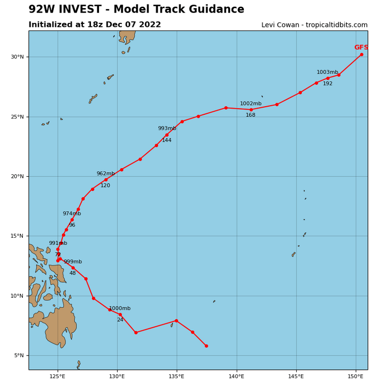
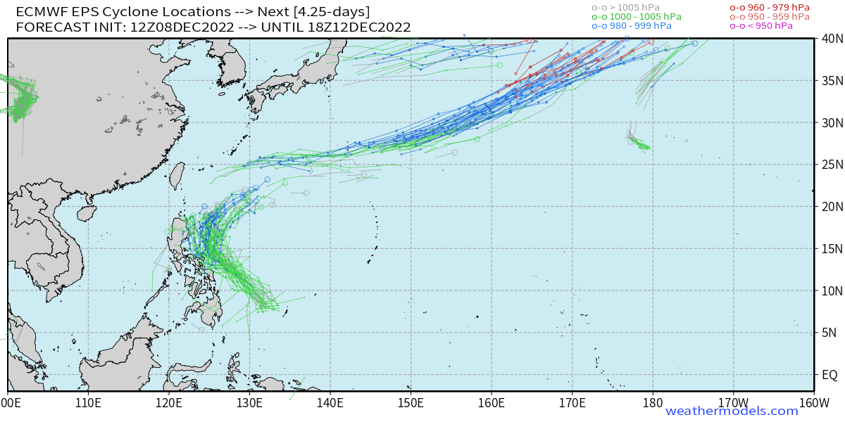
The west pacific TC has been trending to recurving like the gfs had on that previous run. Euro losing on that. There is actually a real feature there now, 92W. It's being picked up by ensembles more and more as well. I think this is giving the boost to the EPO we've been seeing recently. Could help explain why the EPO ridge started trending, and perhaps lend some merit to that.
.thumb.jpg.ea45b059c75b6a20354476f0ea2541df.jpg)
-
1
-
-
Put me down for an order of this. It's just nice to look at.
.thumb.png.b80db26a125d8969ab63421c3facedce.png)
-
7
-
 1
1
-
-
6 minutes ago, EastonSN+ said:
This is really looking more and more like 12/13. December blocking and PAC have similarities. We all know the fun that ensued February and March that year! No two winters are exact but I like the potential. Something that Winter caused the December and subsequent Feb. March blocking.
I think the potential is good this year. The million dollar question is does it pay off or not. We're certainly in a better position than where we could have been without any blocking at all.
-
5
-
1
-
-
9 hours ago, Itryatgolf70 said:
It's kinda amazing to me that we have a pretty negative -ao/nao and still can't get cold lol. It shows you the importance of the pacific to be somewhat favorable. Not sure if a split would do us good with the above diagram you posted. This is my two cents. I believe we need to focus on the mjo and where the main convection is and what needs to happen to get it into the western hemisphere. If it stays in the eastern hemisphere, most likely we will be chasing unicorns all winter. Something to think about.
It's a fair point. There's a reason for that too though right now. The blocking has the TPV pinned by the sea of Okhotsk. So the real cold is pinned in siberia with it. However, the location where it's pinned is also detrimental to it with blocking over the top and near the Urals. The hope for me is that we can nuke it. Which is actually a realistic possibility this year. That would unravel that thing and spread the cold more willingly around the mid latitude belt. Plus, keep the blocking going in the arctic. The Pacific will be variable this season in my eyes. So I'm hopeful for a long lasting -AO this season to work with the times when there are Pacific improvements. That's where my head is at this season. It sure will be interesting to see how it goes.
-
4
-
-
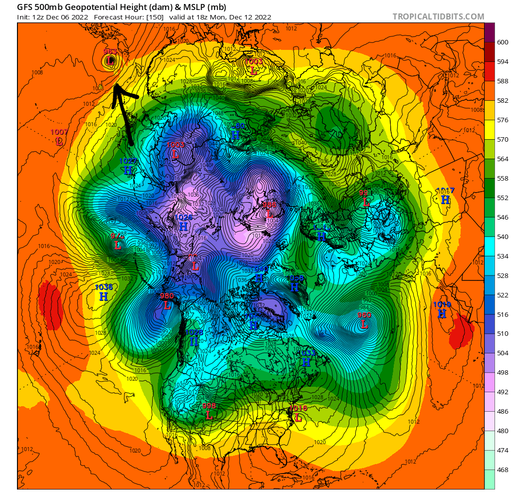
Just to further complicate matters. Don't know if anyone had noticed or not.
Some models, like the gfs here, have been recurving this TC out in the far west pacific in 5-7 days. Absorbing it into the Pacific jet.
Is that thing real, or not?
Gfs says yes. Euro says no.
There is nothing there currently.

-
2
-
-
Seems to me like just a lot of spread towards the end. Except for a miserable vortex again
.thumb.png.d7b6002f50df832d1808d7e488a1f995.png)
-
3
-
-
Day 9 on today's edition
.thumb.png.16784dccfb78a229acf4dacf9198878c.png)
-
1
-
2
-
-
4 minutes ago, EastonSN+ said:
GEFS much improved on PAC side too!
There's a lot going on. It's very complicated for modeling to figure everything out right now. I'm having a blast watching everything though lol.
-
2
-
-
Keep it coming....
.thumb.png.cde9689be18b875a0aa9c3723850cf41.png)
.thumb.png.2df959262d45c7461ba424841dadf18d.png)

-
6
-
-
12 minutes ago, EastonSN+ said:
It's over, I was amped up and holding steady until I saw the 18z GFS. Next year may hold promise.

-
1
-
5
-
-
1 hour ago, MJO812 said:
I think people are getting impatient because they want quick results of the blocking but most of the time it takes time.
Hey who doesn't want snow near the holidays
")
Yup.
But hey it's only December 5th. Who's to say there is no snow near the holidays
-
1
-
-
3 minutes ago, MJO812 said:
Not shocking since the block is enormous .
Yes. And I'm rooting for the SSW hard this year. Well, we've had some precursors too actually so it is very interesting.
But why? Because it would be accompanied by blocking, already set up at 500mb. Whenever you get to do that, you don't need to wait for effects. Like we're used to seeing. The effect from this would be immediate. It's a very rare opportunity, and we're still very much in the hunt.
-
2
-
-
33 minutes ago, brooklynwx99 said:
EPS is absolutely drool-worthy. again, it looks like the date is the 15th with a chance for wintry precip with the 12-14th system

When I see this loop. I see a PV in severe distress. The absolute last thing that it ever wants to do is have itself shoved out to the Aleutians like that. If we want that thing to come unraveled. That would help the cause. A lot. Just look at that poor thing, that's a miserable life for the vortex.
-
3
-
2
-
.png.9598ebbf0b40c2512f4813b5ff95a4d4.png)
.png.77f185e3525e1ab1d7045fd6de2a6fae.png)
.png.57359c9cf542525570a5707bad31c45d.png)

.png.8dcbf2de26b40d8ee4598005922d12be.png)
.png.c12f3375573cdbe30a226491a2feae92.png)
.png.71d5cd41625675cad9d2787b1f9457e1.png)
.jpg.0cbabbf985bf6cfd2fbaef801ab80103.jpg)

.png.82095766a26a8a868ab36297616e7d65.png)

.png.5bc2efaf3ce87c16258c99227debce6a.png)
.png.278394c9d53d03f68c719ca688cdd97f.png)
.png.ecde96bb520d5dc214f3db9bc4db6088.png)
.png.d2d264c45d9dedbf47507e3709bf1dd7.png)

December 2022
in New York City Metro
Posted
06z gfs waits until Monday, but at least showing something this time.