

EasternLI
-
Posts
3,372 -
Joined
-
Last visited
Content Type
Profiles
Blogs
Forums
American Weather
Media Demo
Store
Gallery
Posts posted by EasternLI
-
-
29 minutes ago, North and West said:

.
-
 2
2
-
-
1 hour ago, Volcanic Winter said:
Winter 2023
How it started:

How it's going:

-
 1
1
-
2
-
-
5 minutes ago, jm1220 said:
Western ridge axis is way too far west and no blocking. To me this just means that behind the cutters it gets colder which if it's possible I hate even more because in the winter there's nothing worse than warm cutter to cold/dry. Maybe this can promote some front end snow going into one of the cutters.
Yup, that's probably exactly what we're looking at too. Just kick us while we're down.
-
2 minutes ago, Allsnow said:
Gefs basically kicked the can again….0.0 here we come
Yeah, I'm not seeing much come out of this either. Looks like cutter cold front then ridge on this.

-
2
-
-
3 minutes ago, LibertyBell said:
Maybe because La Nina is really about a warmer west pac?
They seem so destructive I would be perfectly fine with climate engineering that would blunt or at least make la ninas much less frequent.
Oh yeah, it's absolutely about that. That goes back to the gradients conversation too. Without that, it's not going be very effective. That warm pool is going to be a real problem too I think. As it keeps getting warmer. I forsee trouble stemming from that thing, increasingly. I'm not just talking snow either.
-
2
-
-
Oh nice! I got 2 feet in that.
Oh crap, read the room.
*runs away*

-
1
-
2
-
-
5 minutes ago, LibertyBell said:
I wonder why we don't have multi year el ninos, at least triple year el ninos are unheardof in the modern record
There's a reason for that. It's complicated. At least as far as it's understood. This stuff is constantly being studied. It's interesting though, would be cool to check out a much longer record.
-
1 minute ago, LibertyBell said:
Looks like la nina is the normal base state of the Pacific Ocean
Well, from the research I've read. It cycles. On many different timescales too. So you can have a la nina cycle like that where it's more heavily biased la nina. But that alternates too. Some periods are an El nino cycle instead where it's biased in that direction. There's 10 year cycles, 100 year cycles, plus others have been discussed. You still get both types during either cycle. That one is a stark example though. I just wonder how these differences play into how the atmosphere responds. I'm sure it makes at least some difference somehow. I also wonder if you could get some absolute monster events when these cycles line up just right.
-
2
-
-
That's a curious case, 1972-73. Strong el nino in the midst of a ocean of la ninas.
70-71, 71-72
73-74, 74-75, 75-76
All La Nina. A couple strong ones too.
-
2
-
-
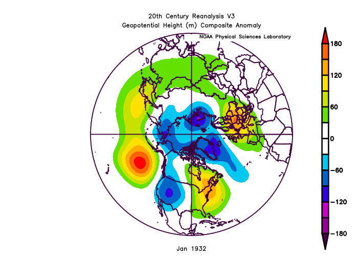
6 minutes ago, EastonSN+ said:
Was 1933 the same as that was a torch too.
Also in the above, is that a south based NAO linking with the SE ridge?
1933 looks very similar in the Pacific. To me, these just look like a huge SE ridge more than anything. I see what you're saying about the first one though.
.png.48cd75b21e46f93f49a94dacc951e60c.png)
-
 2
2
-
-
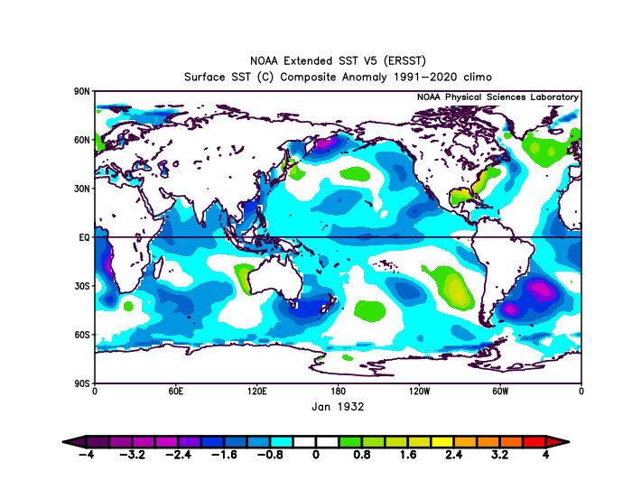
53 minutes ago, LibertyBell said:
Bigger question is, can we catch 1932?
What happened that year to make January so warm? And the climate was much colder back then.
Yeah, that motivated me to take a peek at that year. Interestingly, looks like it was a la nina. Looks like it was a central Pacific one too. Which would make an atrocious Pacific totally plausible. Which it was, apparently. Terrible arctic on top of that. What's more interesting though, to me anyway, is how this is a decaying la nina this year. So with that, the eastern part starts warming up before the western part. So we're in sort of a similar place with respect to that positioning. So it's a little interesting to see us dealing with a horrible Pacific this year too isn't it? Obviously everywhere is much warmer now though being as that was so so long ago, but just focusing on that one aspect. The placement of la nina.
-
2
-
1
-
-
5 minutes ago, EastonSN+ said:
Yeah I was pondering the head-fakes of this year. That being said, we are kind of following the la Nina blueprint so far. Early season snow for half the forum and neg NAO with potential in December occurred (the 2nd storm messed up the 3rd but that's another discussion). The warm/snowless January and potentially Feb.
Late February and March are typically the other window in la Ninas. Sure we could go 11/12 warmth but return of blocking when occurence in December, la Nina tendencies, make me think that this could be legit.
Oh that's totally fair reasoning. If there is a jet extension, that's favorable for mjo propagation too. So we'll have to keep an eye on it. I'm just wrapped up nice and tight in caution flags

-
2
-
-
4 minutes ago, EastonSN+ said:
It's really early, however I have to start wondering if CPK can go through the season with under 1 inch.
If will be difficult with the favorable period coming up as well as the late season volatility, however going into Feb under 1 you have to start contemplating.
Per the below we may be heading towards phase 8 earlier than expected in February. That may be the make or break period of the 5 to 7 day window in Early Feb fails.
I believe Phase 8 leads to Blocking, which would follow the guideline of blocking late season after realizing blocking in December.

A bit of caution from me on that MJO forecast. That may not be what you would think. We've already had a jet extension give us a false signal once. Seeing it rocket east like that now, brings up the memory of that. Just something to consider. We'll see.
-
2
-
-
Felt like looking at the failed ssw attempt a little closer. It's not going to work out, but I like to try to learn why. As I was saying from the earliest mention of it. It's highly dependent upon how the troposphere progresses. Always is, this is where the wave driving happens to cause the warming. To me, in hindsight, it was just a little off. It was close, but it looks like the Pacific just didn't quite get it right. Everything else is there, but again, it's a little off. This one is mainly about the Pacific though I think. I could absolutely be wrong, but that's my guess.
-
2
-
2
-
-
31 minutes ago, snowman19 said:
NAM caved to the RGEM
Euro stopped trying and isn't even out yet
-
1
-
-
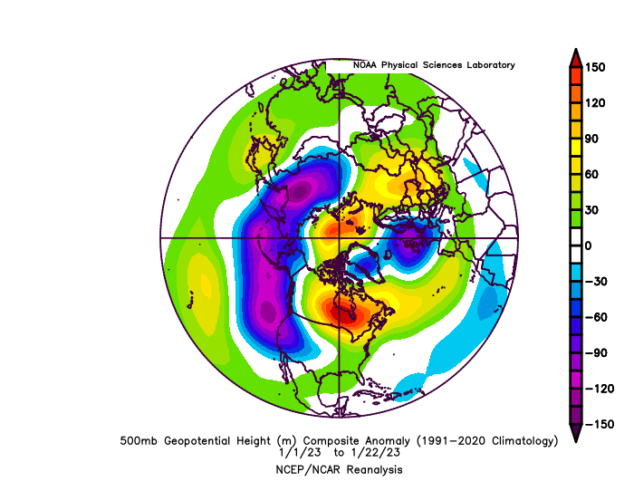
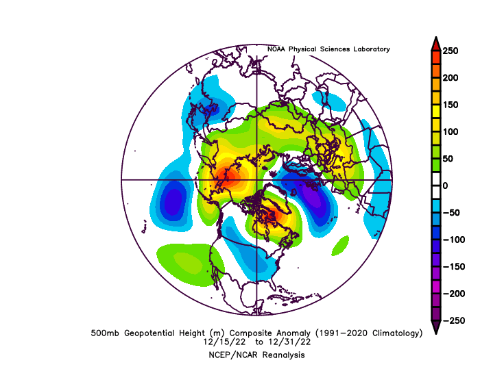
"Gradient pattern"
-
6
-
-
7 minutes ago, Volcanic Winter said:
Is the SE ridge becoming a more permanent fixture of our winter weather? Or is it more due to the recurring La Niñas we’ve been having? I have no way of analyzing that outside of finding it concerning how it’s a recurring problem almost regardless of the pattern, and how it seemed to pop up intrusively less often in the past.
Again this is beyond the scope of my knowledge but if it’s conclusively tied to SST’s in the Atlantic that seems like it’ll continue to be a big problem. I’m sure there’s more to it than that (I hope so).
Just wondering aloud.
JMHO, I feel like it's la nina. It feels semi permanent because we're dealing with this multi year la nina. There was a time I recall, some years ago now, where the +PNA was viewed in the same way. When we had a more el nino like phase going on. It'll likely change, it all works in cycles.
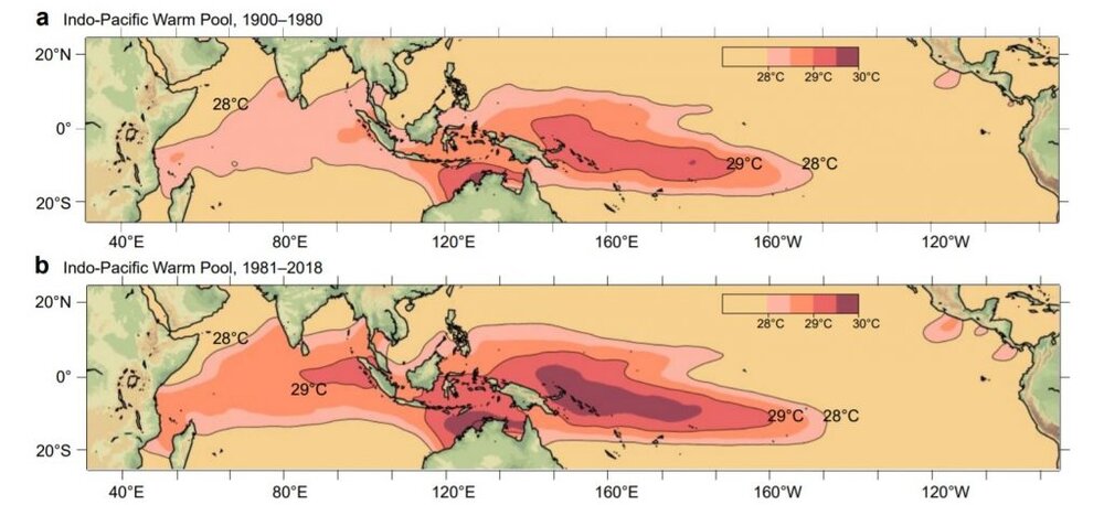
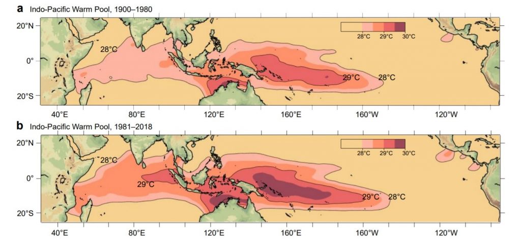
We need to be careful though in current times. The Pacific warm pool area likes to drive a -PNA. Depending upon how it's positioned. This is why la nina often does that. It's a prominent component in these. That area is also expected to continue to expand and get warmer as the years go by. It's a huge reason why we'll often bring up that particular feature. It's very important. But recall the discussion about gradients. La nina amplifies this effect by increasing that gradient with cool water to the east.
-
1
-
-
10 minutes ago, snowman19 said:
It might propagate out into the Pacific in early March? I don’t know, I’m starting to think March isn’t going to be all that good. If the SPV restrengthens mid-late February, I think it’s overLag effects from the imminent phase 3 forcing is going to want to shift the vortex towards Alaska beyond what we're seeing now I think. March I'm not sure, always a tricky month. But I feel like north America could be in rough shape in terms of cold if it plays out like that.
-
2
-
-
12 minutes ago, EastonSN+ said:
So far the Blocking has not returned as it typically does following blocking in December.
I know we all expect it/fear if for April.

We have zero shot at that blocking for the reliably foreseeable future IMO. With the failed ssw attempt pushing down +AO conditions upon the troposphere. That would need to subside first. Then, after that, something needs to force it. We've got no signs of any of that happening anytime soon. This is why I was viewing that event as being very important.
-
3
-
-
Feels like watching a bad rerun of a TV show looking at ensembles. There is some cold going to be dumped on this side of the planet. True. Due to the ridging over Alaska. Problem I'm seeing, is that it's dumping into western Canada first and would need time to bleed east. This is normal but this is all still in motion.
.thumb.png.d59af1cec9dde9d2e79889b6f11d48f0.png)
It looks like there's a Pacific wave break which will give this a shove to the east. So yes, this would suggest a cold shot in our area. In early February as a result.
.thumb.png.b79b10c7048de80884a0b90567d2430c.png)
However that looks really transient as by doing this, once that trough is pushed east it breaks. Because another Pacific wave break pinches off the ridge by Alaska and it starts to retrograde to Russia.
.thumb.png.a3e86f6a2488e80f7a8fad9518b1a31d.png)
So when that trough breaks in the east it is replaced with a ridge. As we've seen displayed before during this season. So I think this all means a very transient cold shot in early February. There's a chance to pull off something with this progression as some select few ensemble members suggest. However it would take some impeccable timing to accomplish. Which we have yet to witness with basically anything this season. This is all based off what the ensemble means are showing this morning anyway. Gefs displays the same general idea as well.
-
3
-
1
-
-
4 minutes ago, jm1220 said:
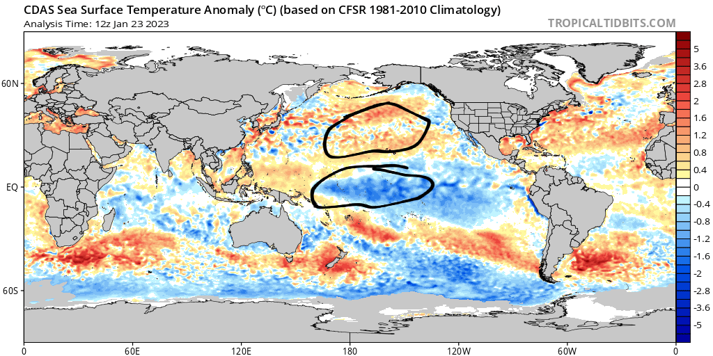
Most attention goes to the E Pacific for the ENSO SST changes but it's also about the contrast with the W Pacific. The cold Nina E Pacific isn't all that cold, but the scorching W Pacific enhances the Nina pattern. It'll be interesting to see if the next Nino can cause that to shift.
Exactly.
These are the important factors to watch for. This also applies to the PDO. It's perhaps far more important than it gets credit for from most. Check out this year. La nina with negative PDO. So there's a contrast, albeit it was stronger earlier in the season.
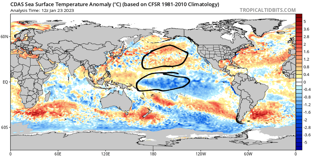
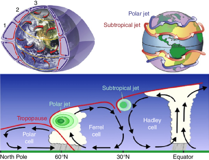
Whatever enso is, are less effective in the Pacific without this contrast. Not saying zero, just less. This is a weakening la nina, probably not the best example. It's the same thing for el nino, but opposite anomalies. It becomes a lot easier for one to see the difference between enso events and their outcomes, with these general concepts. We get the same general idea from the jet diagram. It's easy to see how these contrasts factors into the equation in a big way by strengthening or weakening these circulations. It's all such a fine balance, which I know you know. Maybe this helps others understand how it all goes together.
-
1
-
-
11 minutes ago, EasternLI said:
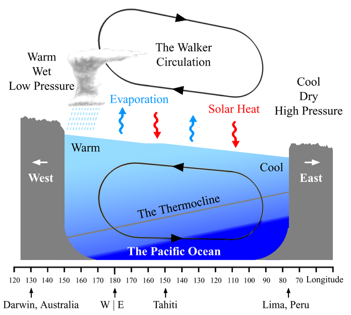
I know a lot of people are excited to hear El nino is likely, and it is. However, the last one we had (18-19) didn't have much in the way of sst gradients. I've done some reading which explains this is a factor that is significant. We'd like to see some cooler water around the Pacific warm pool area with it. Or at least have the el nino stronger than the warm pool. Could behave more enso neutral like otherwise. It's interesting and makes sense if you think about it. It's really the gradients that make things happen with our weather too.
Don't remember where I read that. But it's because of the walker circulation.
-
1
-
-
10 minutes ago, LibertyBell said:
I wonder what the chances are of a 2002-03 or 2009-10 type of el nino. Granted, getting to high end moderate doesn't mean it's going to be cold or snowy, 1994-95 and 2006-07 were like that too.
I know a lot of people are excited to hear El nino is likely, and it is. However, the last one we had (18-19) didn't have much in the way of sst gradients. I've done some reading which explains this is a factor that is significant. We'd like to see some cooler water around the Pacific warm pool area with it. Or at least have the el nino stronger than the warm pool. Could behave more enso neutral like otherwise. It's interesting and makes sense if you think about it. It's really the gradients that make things happen with our weather too.
-
1
-
-
52 minutes ago, brooklynwx99 said:
not really sure. it's probably just bad luck... if the shortwave that led to the cutter came in a day later, it would have been a huge coastal storm, but the ridge was too far W
and then the follow up wave was a day too late and the ridge broke down out west. just really bad timing, could have been a very good stretch. luck is always in our winters here
I think the lack of a 50/50 did us in. Although we were modeled to get one for a time. Totally agree with your point here. Our timing has just been off. We just can't time anything to workout favorably. Anywhere with anything it seems like. If that makes sense. Including big picture stuff. All season long. It's amazingly annoying. This block belongs in the trash let us never speak of this block again lol.

-
1
-


.png.1563911e7bba0e1021423c231f755496.png)
.png.cac45bc2093d2a3fff22cf9a50724623.png)
.png.3c617cca2f56f05a4fe7dc6cc7c75860.png)
January 2023
in New York City Metro
Posted
That was slightly intriguing from 12z. I thought the gfs was on drugs trying to pull up some blocking to Greenland later in the run. Bit eyebrow raising to see the euro trying to do that too at the end though. So this is a little bit different now from the gfs. That was the first run trying to push down some of the weakening winds from upstairs into the troposphere. Not sure if the euro is trying that too. Curious to see if that keeps showing up now though.