

Tyler Penland
-
Posts
2,244 -
Joined
-
Last visited
Content Type
Profiles
Blogs
Forums
American Weather
Media Demo
Store
Gallery
Posts posted by Tyler Penland
-
-
Just barely under 11" and dumping in Foscoe.
-
 2
2
-
-
9.5" and dumping. I think I'll finally get my first foot of snow this time.
-
1
-
-
Not sure where we at but it's adding up quick. Pouring right now. Flakes have gotten a little bigger.
-
1
-
-
Finally some flakes here. Down to 33. Here's to waking up to a foot.
-
Still waiting here in foscoe. Snowing everywhere around me it seems like.
-
Nothing in Boone 20 minutes ago. Still nothing a few miles south of town right now. Should start soon though.Managed to drop a doe approximately an hour ago, before dressing weighed around 140 so decent size. Still no flakes but hoping to maybe hit some as I drive back to Boone here in a bit-
1
-
-
18z 3km NAM. This was through hr42. Haven't had a chance to check and see if it got more.
What I’d do to see that come to fruition. Which model run?-
1
-
-
For posterity and entertainment. 38" bullseye South of Boone.

-
1
-
-
Morning folks! Busiest day my store has ever seen yesterday. Crazy stuff. I see the 6z NAM was super juicy for the northern mountains. Good luck to all!
-
Ha. Mt Mitchell gonna get hammered.

-
Per his Twitter he's in Asheville. Mostly rumors. I seen Watauga roads posted it on fb though.Cantore is headed to boone!-
1
-
-
They always come NW a little. Always.So...not too get too excited...but that 18z NAM has the low MUCH closer to the coast, get any closer and we've got a chance at a longer duration of heavy precip...This might be worth watching on that aspect. -
Models swing and miss on northern edge precip a lot. Obviously the SW mountains will be in a better spot but I'm guessing we do just fine.To your point Ashe, I guess these are a few things we need to keep an eye on. I've seen all of these happen and sometimes all at the same time. From Ray.....
Caveats....
Factors that would limit snow totals: 1) latest computer guidance limits precipitation on the northern edge of the system, 2) relatively warm temperatures aloft have me nervous (mixing with sleet or freezing rain would greatly limit totals). 3) "Convective robbing" where thunderstorms along the Gulf Coast limit the transport of moisture northward can often be a factor in a system like this.
-
Is it just me or is radar already way juicier than it's supposed to be?
-
1
-
-
NAM much wetter.
-
Where are you pulling that from?GEFS mean back up to near 17 inches at KAVL, QPF 2.6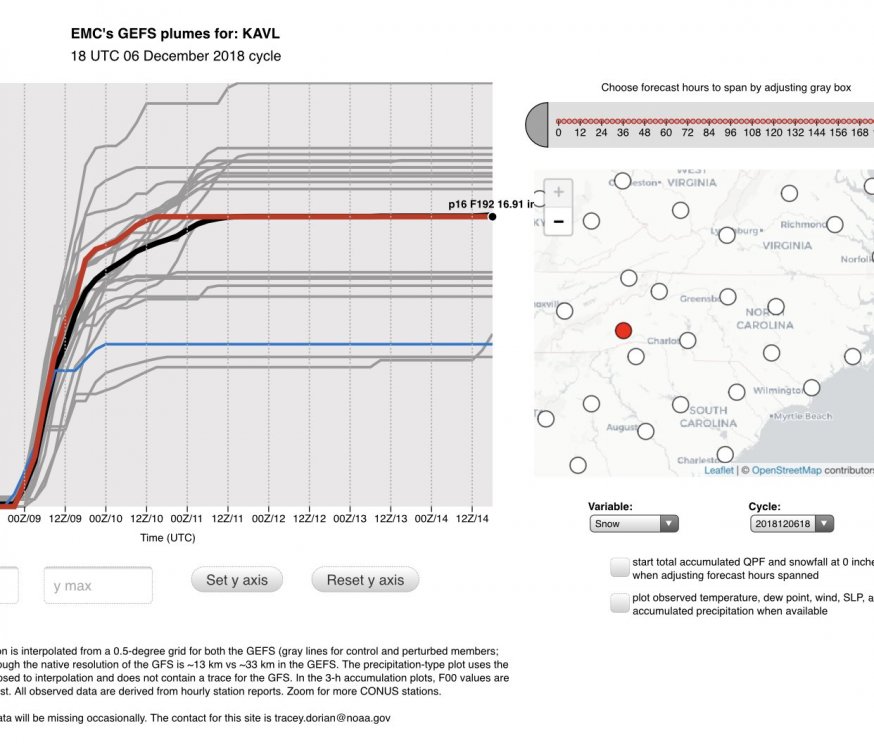
-
Ukmet on board too, no? I didn't see the 12z cause I was slavin'.To think that the FV3 and Euro are both showing close to the same solution... Makes you wonder. -
-
Holy hell the 18z fv3 is juiced up.

-
4 minutes ago, HKY1894 said:
Yeah way to early to call bust especially northern mountains globals all look absolutely great right now only bad model is nam and it’s not even bad in mountains still drop 14 or more in Boone. More worrisome for Asheville area but if globals are closer to reality even you guys are gonna get hit hard. The NAM past 48 hours has been a total joke in the Midwest with this even so it’s laughable to even consider it right now
.The skew-t's for the Asheville area don't really show a major warm nose on the NAM. Literally looks like it takes part of the column above 850 just *barely* above freezing. Still easily overcome by even decent rates IMO.
-
2
-
-
SkewT for the NAM at the one frame it shows sleet for Boone. Entire column well below freezing at 69 and 75 so I would think any sleet would be very brief and fairly easily overcome by rates.

-
1
-
-
I'd go with spruce pine. Better infrastructure to power back or get out. There ain't nothing out around Sparta lol.Still 48hrs out, but starting to look at Spruce Pine vs Sparta.-
2
-
 1
1
-
-
Still snowing pretty good here in Vilas. Amazed this is still going tbh.
-
Aaaand near whiteout again.
Sent from my SM-G960U using Tapatalk


2018/2019 Mountains and Foothills Fall/Winter Thread
in Southeastern States
Posted
About 10 3/4" in foscoe. Pouring right now. Over an inch in the last hour.
Of note no wind at my locale.