Tyler Penland
-
Posts
2,523 -
Joined
-
Last visited
Content Type
Profiles
Blogs
Forums
American Weather
Media Demo
Store
Gallery
Everything posted by Tyler Penland
-

2022-2023 Fall/Winter Mountains Thread
Tyler Penland replied to BlueRidgeFolklore's topic in Southeastern States
Euro and GFS have both actually been on this one for the past few days. GFS more than the Euro but they both have had some "good" runs (good if you want more cold and snow, which I do not). We made 33.1 this morning. Sent from my SM-S911U using Tapatalk -
2022-2023 Fall/Winter Mountains Thread
Tyler Penland replied to BlueRidgeFolklore's topic in Southeastern States
What happened to spring? I have a day off and suddenly it's 43 and raining. Still went fishing but it wasn't as fun. Sent from my SM-S911U using Tapatalk -
2022-2023 Fall/Winter Mountains Thread
Tyler Penland replied to BlueRidgeFolklore's topic in Southeastern States
You can sign up for free notifications from spaceweatherlive.com and it'll send push notifications for flares and geomagnetic activity. I just changed phones and didn't have them enabled yet or I'd have been out earlier yesterday. I really caught the tail of the best conditions. Sent from my SM-S911U using Tapatalk -
2022-2023 Fall/Winter Mountains Thread
Tyler Penland replied to BlueRidgeFolklore's topic in Southeastern States
It was a weird storm. No flares that we know of, just a perfect set of circumstances that got the Bz to tip south. Sent from my SM-S911U using Tapatalk -
2022-2023 Fall/Winter Mountains Thread
Tyler Penland replied to BlueRidgeFolklore's topic in Southeastern States
Not ground weather related but space weather news. Caught the auroras last night up north of Boone. 3rd time seeing them from down here which is awesome. Eventually I'll get a chance to go north and see the big ones. Sent from my SM-S911U using Tapatalk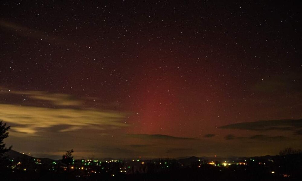
-
Mid to Long Range Discussion ~ 2023
Tyler Penland replied to buckeyefan1's topic in Southeastern States
EPS isn't setting the world on fire either. Sent from my SM-S911U using Tapatalk -
2022-2023 Fall/Winter Mountains Thread
Tyler Penland replied to BlueRidgeFolklore's topic in Southeastern States
All I had to do was fly out to Portland and suddenly winter decides to actually produce. Sent from my SM-S911U using Tapatalk -
2022-2023 Fall/Winter Mountains Thread
Tyler Penland replied to BlueRidgeFolklore's topic in Southeastern States
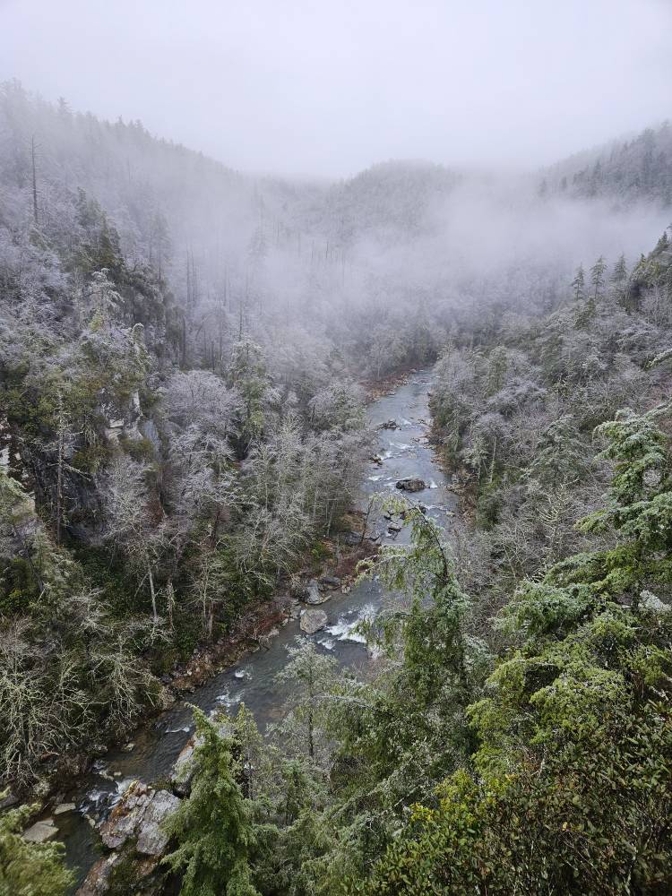
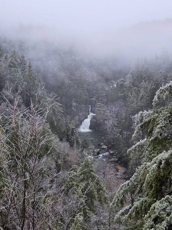
Stopped at Linville Falls on the way down to Asheville. Few cell phone shots. Absolutely gorgeous, albeit miserable hiking conditions. Sent from my SM-S911U using Tapatalk.jpg.10f09ea221b1c1725a4f32f81cf1883e.jpg)

-
2022-2023 Fall/Winter Mountains Thread
Tyler Penland replied to BlueRidgeFolklore's topic in Southeastern States
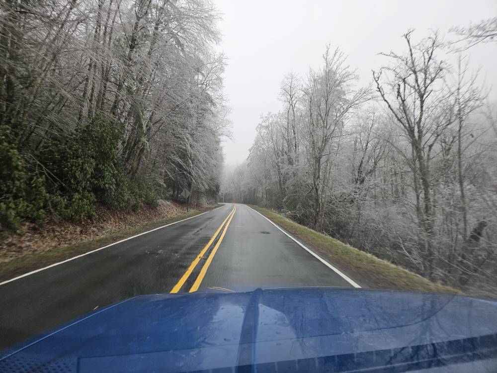
Sleet early and a quarter inch of freezing rain now. Yay? Sent from my SM-S911U using Tapatalk -
2022-2023 Fall/Winter Mountains Thread
Tyler Penland replied to BlueRidgeFolklore's topic in Southeastern States
Down to 35 under crystal clear skies. Definitely getting some nice radiational cooling going for now. Sent from my SM-S911U using Tapatalk -
2022-2023 Fall/Winter Mountains Thread
Tyler Penland replied to BlueRidgeFolklore's topic in Southeastern States
Good look from the HRRR. Sent from my SM-S911U using Tapatalk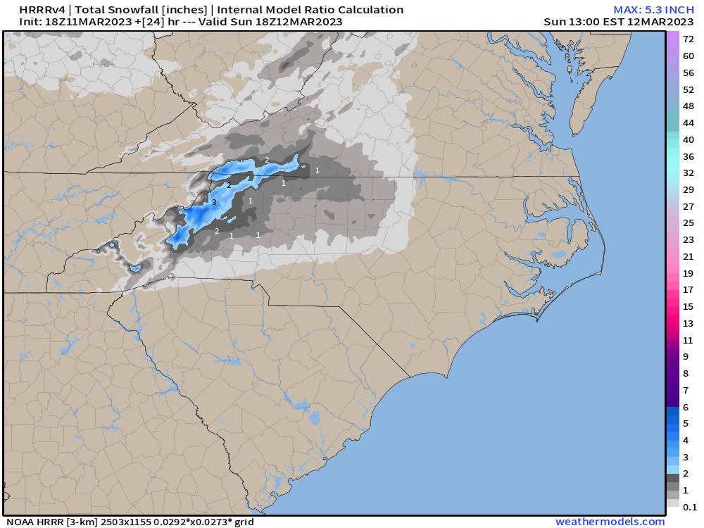
-
Sunday March 12th white rain tracking
Tyler Penland replied to olafminesaw's topic in Southeastern States
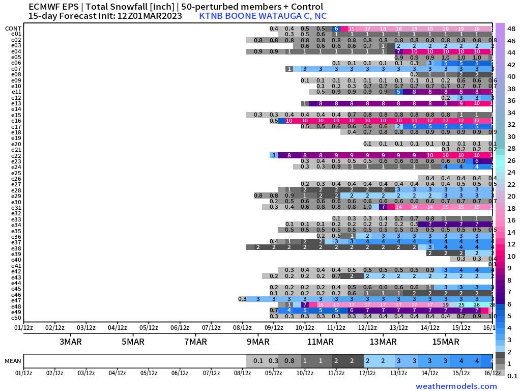
With a little luck Boone could quadruple the official snow total for the winter with this one. Of course the airport is currently at a half inch on the season so it's not like it's gonna take much. Concerned about sleet mixing in but if we can avoid that I wouldn't be surprised for some spots up here to get 3-4" Sent from my SM-S911U using Tapatalk -
2022-2023 Fall/Winter Mountains Thread
Tyler Penland replied to BlueRidgeFolklore's topic in Southeastern States
HRRR actually looks dang close to staying all snow through lunch tomorrow. 12z is a snow/sleet mix as is. Sent from my SM-S911U using Tapatalk -
2022-2023 Fall/Winter Mountains Thread
Tyler Penland replied to BlueRidgeFolklore's topic in Southeastern States
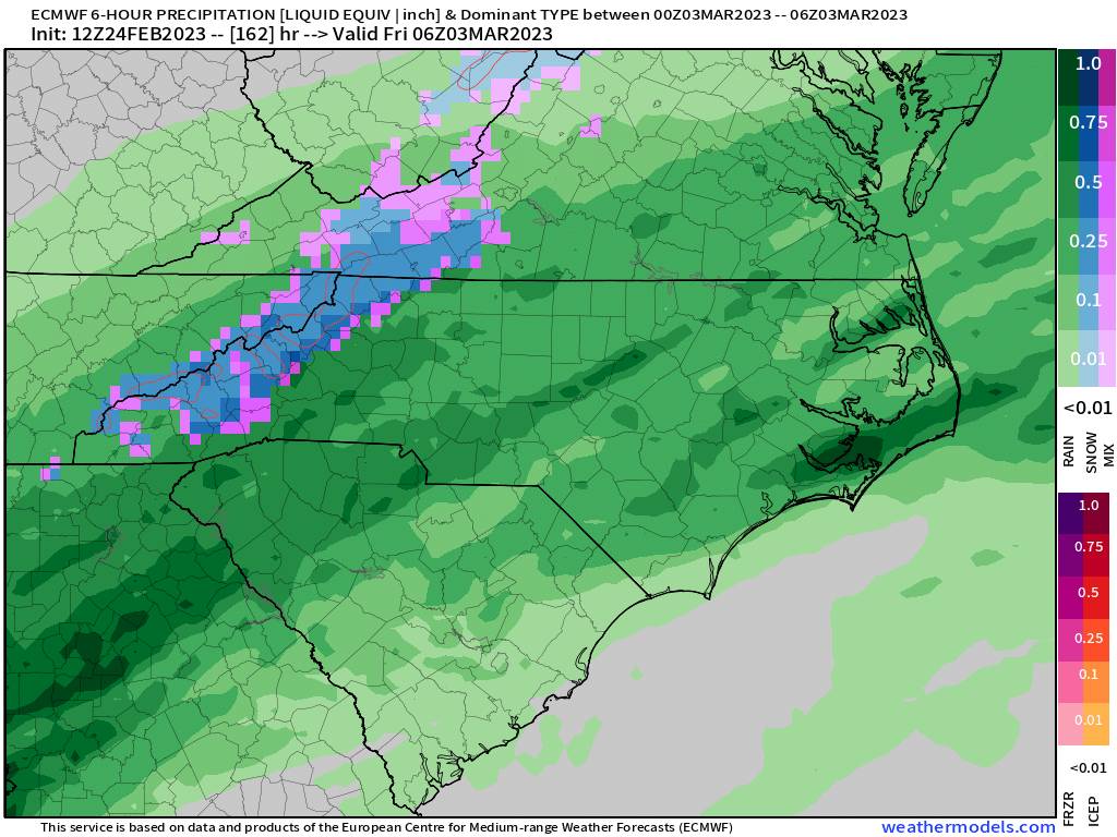
Lots of ZR/IP Sunday on the NAM. Having the globals in agreement concerns me about this one. Good news I suppose is how warm we've been lately and temps come up towards freezing very quickly. Sent from my SM-S911U using Tapatalk -
2022-2023 Fall/Winter Mountains Thread
Tyler Penland replied to BlueRidgeFolklore's topic in Southeastern States
If anybody has any photos from the Blizzard of '93 from SW NC or especially NE GA (story is for a website in Habersham) I would love to use them in a story I'm doing on the 30th anniversary. Having a hard time finding photos. -
Mid to Long Range Discussion ~ 2023
Tyler Penland replied to buckeyefan1's topic in Southeastern States
The EPS has been pretty consistently showing the potential on Sunday for the past week or so, at least for Boone. Also NASCAR will be in Atlanta on the 19th so you can pretty much guarantee that cold snap. They bring the best weather with them everywhere, including snow to Fontana, CA. Sent from my SM-S911U using Tapatalk -
2022-2023 Fall/Winter Mountains Thread
Tyler Penland replied to BlueRidgeFolklore's topic in Southeastern States
EPS has been honking this storm on and off. Definitely concerning but I'm waiting for the hi res. Sent from my SM-S911U using Tapatalk -
2022-2023 Fall/Winter Mountains Thread
Tyler Penland replied to BlueRidgeFolklore's topic in Southeastern States
0z EPS ticked up snow. Starting to see more members jump on Thu/Fri time frame. -
2022-2023 Fall/Winter Mountains Thread
Tyler Penland replied to BlueRidgeFolklore's topic in Southeastern States
Weirdly calm here in Blowing Rock but it's been dumping rain for an hour. -
2022-2023 Fall/Winter Mountains Thread
Tyler Penland replied to BlueRidgeFolklore's topic in Southeastern States
Looking a little rough with the storms and wind later today. -
2022-2023 Fall/Winter Mountains Thread
Tyler Penland replied to BlueRidgeFolklore's topic in Southeastern States
12z for Boone. I'm supposed to be flying out to Portland on the 13th, looks interesting to say the least lol.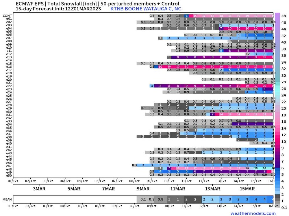
-
2022-2023 Fall/Winter Mountains Thread
Tyler Penland replied to BlueRidgeFolklore's topic in Southeastern States
Air temp has gone up 9 degrees in the last couple hours as the wind has picked up. What a weird February. -
2022-2023 Fall/Winter Mountains Thread
Tyler Penland replied to BlueRidgeFolklore's topic in Southeastern States
0z Euro was close for the northern mountains. GFS took a step in that direction as well. -
2022-2023 Fall/Winter Mountains Thread
Tyler Penland replied to BlueRidgeFolklore's topic in Southeastern States
Um. OK then Euro.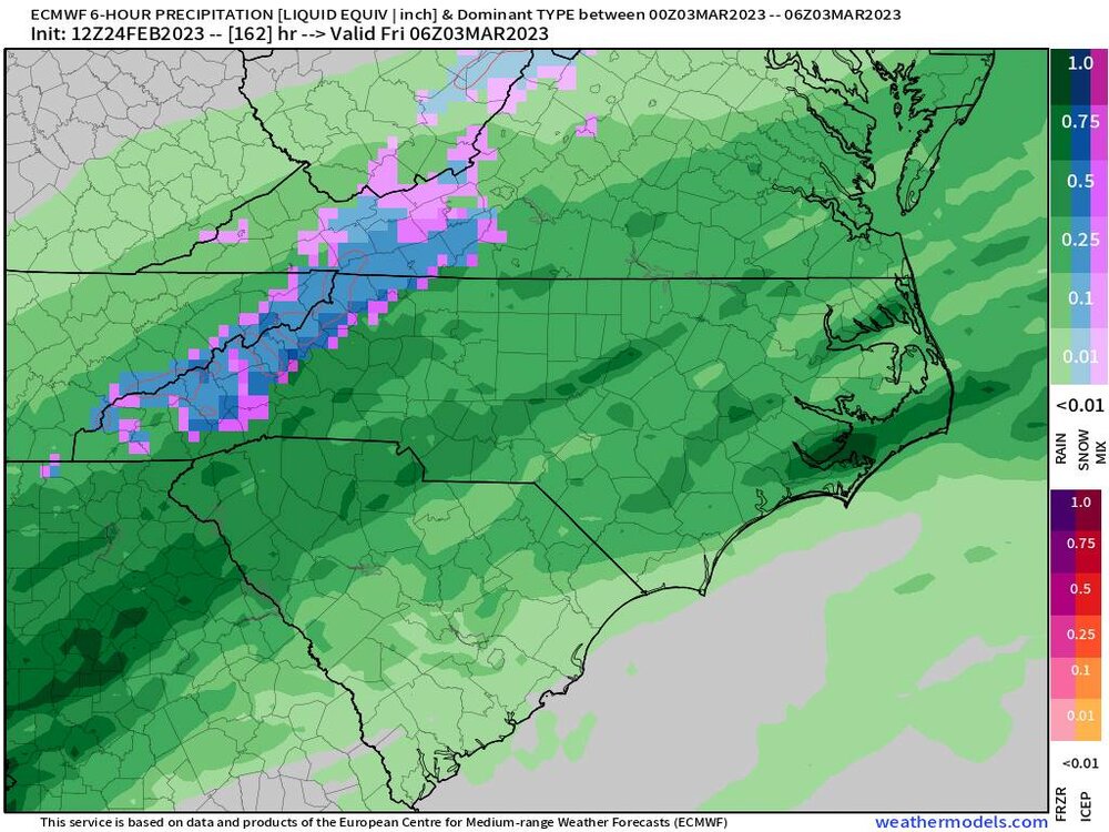
-
2022-2023 Fall/Winter Mountains Thread
Tyler Penland replied to BlueRidgeFolklore's topic in Southeastern States
Blowing snow here in Blowing Rock now.