nzucker
-
Posts
10,771 -
Joined
-
Last visited
Content Type
Profiles
Blogs
Forums
American Weather
Media Demo
Store
Gallery
Everything posted by nzucker
-
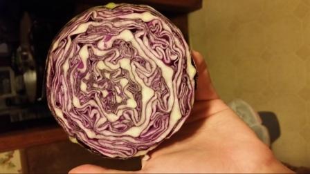
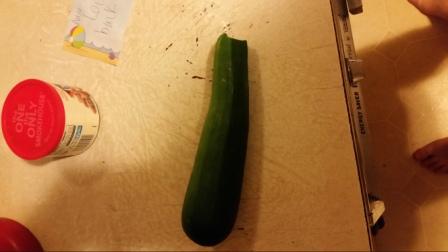
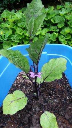
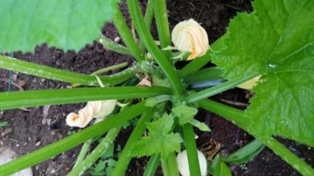
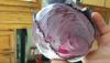
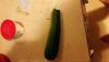
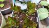
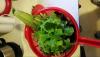
LOL, thanks for calling me out...Got some new stuff coming along in the garden. This was one of the smaller red cabbages I harvested... Inside of a large red cabbage freshly picked. Eggplant now has a fruit, was just developing in this photo. My first zucchini, although powdery mildew and cool weather has slowed plant down. It hasn't been that hot here this year, although the last few days in the mid 80s has pushed the garden along. I should be harvesting cherry tomatoes within a week or so, regular sized tomatoes in 2 weeks, along with eggplant and zucchini. I am still harvesting cabbage, and a big green one is almost ready to be picked. Cabbage has been one of my highlights this year, excellent crop with delicious flavor. I also made a bunch of pesto with all my basil, as I have at least 20 plants. Will update this thread more as the garden warrants...

-
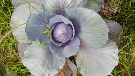
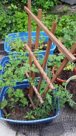
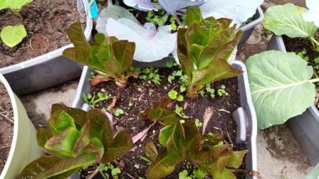
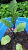
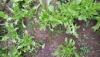
Here are some pics from this year.. Usually grow Apollo Arugula but this variety with serrated leaves is good too, looks a bit like frisee. Red cabbage planted in early April, almost ready...also have the green variety. These guys get huge. Growing slowly with the cool weather. Love fresh eggplant though, makes pasta delicious. Tomato plants have a few flowers but also suffering from lack of heat. Lettuce has gone nuts this year, bought this early April and has yielded for almost 2 months. Can't wait to harvest my first zucchini. Has some powdery mildew though... Love making salads with fresh greens from the garden.


-
Great thread, always follow it closely. I live north of NYC on a small suburban property so have a cooler climate and less space, but I manage a garden. Here is what I have: 8 lettuce plants, mostly oakleaf 8 cabbage, some red, some green 2 varieties arugula, mostly Apollo 1 kale 20 basil/purple basil 4 tomatoes, cherry, beefsteak, Lemon Boy and Brandywine 4 peppers, sweet and hot 2 zucchini 2 eggplant, Black Beauty and Japanese 1 winter squash, Guatemalan blue oregano dill wild mint thyme sage tarragon I have harvested a lot of greens and herbs, especially arugula and oakleaf lettuce which went nuts. Basil has gotten huge. Zucchini has several fruits but not big enough to harvest.Tomatoes are flowering and so are eggplants but no fruits yet. I have a second round of arugula getting ready. We don't have nearly the heat...most days this June have been in the 70s, a few in the 60s, and the first two days of June had highs of 58F and 54F. So it's a little different up here...I have been gardening since 2008 and learned a lot. Just started composting again, and can't wait for this year's harvest.
-
Definitely something wrong with the Teterboro ASOS...well north of PHL and TTN but more 90 degree days. Seems fishy.
-
We won't make the 2010 record with the trough moving in by later in the week, even if we don't snap the streak tomorrow morning.
-
You mean a good good night?NYC has been sitting just short of 90F today...85F there right now as clouds are preventing forecast highs from being realized.
-
Almost definitely.
-
August will probably be the coolest month of the summer with what models are showing and the developing Nino. It wouldn't surprise me to see a taste of fall early.
-
I started posting in Summer 2008, so I was on for the 08-09 winter...I was home from Middlebury in Westchester for the Dec 19-21 storm...had about 8" or so from the 12/19 event, then 3" plus icing from the second wave although it turned to rain in NYC proper. It was a huge double-barreled event in Vermont with about 10" from each storm. The New Year's mega torch ruined most of the snowpack but January 2009 was just epic in Vermont, had the fluff clipper early in the month and then the monster SW flow event on 1/28 that dropped over a foot. I left to study in Chile a few weeks later but what a great front-loaded winter that was. Your posts have been great man...you are a wonderful contributor to the forum.
-
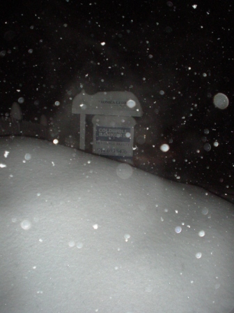
This was Dobbs Ferry during the 1/27 blitz...great memories: Amazing to think how bad this winter is: last year I had nearly 30" of snowpack at 350' right outside NYC; this year, I'm thankful for a coating on the ground at 1200' in the Monadnocks.

-
That was probably very solid here, just managed like 8" in Dobbs Ferry. I know lots of CT/MA had 15-20" with Feb 01 though. Birch Hill Dam, MA located quite near here had 24" in that storm, and received 31.5" that month. I guess it's partially a false impression that the interior can't get big Nor'easters because of the sharp cut-offs with the last few years such as 12/26/2010 and 2/10/2010 when the coastal areas got far more than expected from climatology. I'm sure it will shift back to the interior areas and we'll see some stretched like Jan 2002 or March 1958 where the Poconos/Catskills/NY capital district/interior NNE cash in.
-
2/25 was not an elevation event in Central VT....Middlebury got 20" at the bottom of the Champlain Valley. We had a nice slug of moisture moving due north with that coastal low forming, classic signal for the CPV to get blasted. We barely stayed all snow though. I think interior NNE is favored with the -QBO/Nina. I'm really liking where I'm sitting though Rindge probably isn't the best place for 20"+ events since it's fairly far from the coast.
-
Alaska/Western Canada obs and discussion
nzucker replied to patrick7032's topic in Central/Western States
I saw +SN at the Columbia Icefields in Banff/Jasper in August 2000. We went out on the snowcat and had a great time. -
Alaska/Western Canada obs and discussion
nzucker replied to patrick7032's topic in Central/Western States
Wow, the Yukon is beautiful...those pictures are absolutely stunning. I love the contrast of the foliage from the birches with the coniferous species that inhabit the area as well. -
Alaska/Western Canada obs and discussion
nzucker replied to patrick7032's topic in Central/Western States
I am loving your updates from the Yukon, can't wait to hear from you in the winter. And yes, the fall colors are beautiful. Are those mostly aspen in the Yukon? We just have a few trees turning here in New England, still a good month before peak foliage season here. Someday will make it up that way. Have been to the Rockies in Banff/Jasper so have a bit of a taste for alpine Canada, but the Yukon mountains are another level of extreme. -
If I remember correctly, it started out as a SW flow event that transferred to a coastal. I recall the NYC people getting really excited about the 2/24 storm, and I told them they should forget about the first event since it was a SW flow situation with no arctic high to the north (you can see the -20C contour on the reanalysis maps is barely touching Northern Labrador), and concentrate on the 2/25 Snowicane. This turned out to be a prescient forecast as NYC was all rain in the first storm, but Central Park got 20" in the Snowicane while places 50 miles to the north like Highland Mills NY and Harriman NY saw over 30". I may have gone downhill since with my mediocre Winter 10-11 forecast, but I was on a hot streak in forecasting at this point....I was repeatedly criticized in the NYC threads for suggesting that the 2/24 storm was going to be a rain event, but I went on our radio show on WRMC at Middlebury with Andrew and called for 16-20" at Middlebury (about 48 hours out) when the NWS was only forecasting like 6-10". Everyone played the storm extremely conservatively including both the BTV NWS and the TV stations, but Skier and I were convinced it was going to be solid for the Champlain Valley because we had a strong moisture stream coming south out of the Hudson Valley, which has a direct feed into the CPV, and heavy precipitation in a short period of time, which tends to reduce the downsloping effect and allow the Champlain Valley to do well compared to the more elevated areas. Usually, long-duration, light precipitation storms are when downsloping gets the best of the Middlebury area, but this was an 8-hour thump that could maximize accumulations at low elevations with marginal temperatures. Skier called for 12-16" while I went pedal to the metal and called for 16-20", both of which were FAR more than the NWS forecasts, and we ended up doing very well on the event. The campus, according to our measurements, received 20" of paste, some of the heaviest snow I'd ever seen...made for a beautiful sight on all the old buildings. When I woke up the morning of the Snowicane back in NYC, I immediately said I thought Central Park would get 20"+ based on the strong radar echoes streaming from the NE and the fact that Central Park had started as mostly snow whereas other stations like HPN/White Plains were reporting rain at 32/32 or 33/32. This was also a good forecast as they had a bit over 20", and suburbs to the north like mine got pasted. This was the most snow I'd seen in 2 days, 46". I drove home right after the 2/24 storm, steering carefully on the snowy Vermont roads at 1am in an attempt to get home for the Snowicane despite a very heavy workload in the middle of 2nd semester of senior year. I arrived home to a rain/snow mix, slept for 6 hours, awoke to a whiteout. Those were two great storms....the first was just so unexpected because the BTV NWS and the Vermont TV stations did not give the storm the proper billing, and the Snowicane was an absolute nail-biter with the 0C 850 contour right over Westchester County...somehow I stayed all snow at 350' elevation despite mixing to my west near Nyack NY and to my northeast at HPN/White Plains Airport. The 26" I measured was not indicative of downtown, however, as I took my final measurements in the woods behind my house closer to 400' altitude. The Scarsdale Wunderground station, which is a more built-up area a couple hundred of feet lower, was at 33.9F for much of the day and did not accumulate as well. I'd say the town of Dobbs Ferry had 21-22", though I didn't measure there, just noticed the drop-off. This was such a weenie period of my life....never mind that I was in the middle of my thesis and last semester at Midd, I walked around all day during the 2/24 storm, hiking up to a hill at 800'...then I arrived home at 4am the next morning to see the Snowicane. I was glad I forecasted the event well as we had people like environmentalist Bill McKibben and a couple environmental science professors sometimes tuning in to our show.
-
But I only got 14"!!!!
-
We got 20" of absolute cement in Middlebury VT from the 2/24 event, but the snowpack was devastated quickly by the heavy rain that followed in the 2/25 retrograde Snowicane.
-
Unbelievable shots, Will, telling the story of the Dec 2008 storm that ended tragically for parts of elevated SNE. Impact was minimal in Middlebury as the trace of ice on top of the 7" snow was the only sign of the destruction further south, but I was delayed for quite a few days trying to take Amtrak home...the train had to cross some of the harder-hit terrain north of ALB. Really incredible what some of those areas went through, rivals Quebec in Jan 1998.
-
Those winters give a pretty cold picture nationally, especially in the Northern Tier, definitely related to the gradient you have mentioned:
-
What other examples do we have of cold ENSO/-QBO/-PDO? How do winters like 74-75 and 83-84 compare?
-
-
I think most people are expecting a -NAO. Consensus seems to be we'll have a decent winter with a weak Nina, -QBO/low solar, and -NAO cycle. No one really knows though, that's why weather is fun! Here was my snowpack:
-
High was 86.8F, about 2F above average. Unfortunately, it's another mild night despite the clear skies, so the AC has gone back on. FAIR 73.4/62