patrick7032
-
Posts
1,026 -
Joined
-
Last visited
About patrick7032

- Birthday 03/16/1973
Recent Profile Visitors


-
That's interesting. I'll have to try using that method...compared to the one I used as a student volunteer when I was at DTX and GRR. The way that I was taught was to take the height (in meters) of the freezing level...and multiply by 0.013. I still use this today...but just add 5 to whatever value the VOD was and it seems to work good. At my office we pay more attention to the height of the 50 dbz echos and have certain thresholds that we pop the SVR warning on.
-
Alaska/Western Canada obs and discussion
patrick7032 replied to patrick7032's topic in Central/Western States
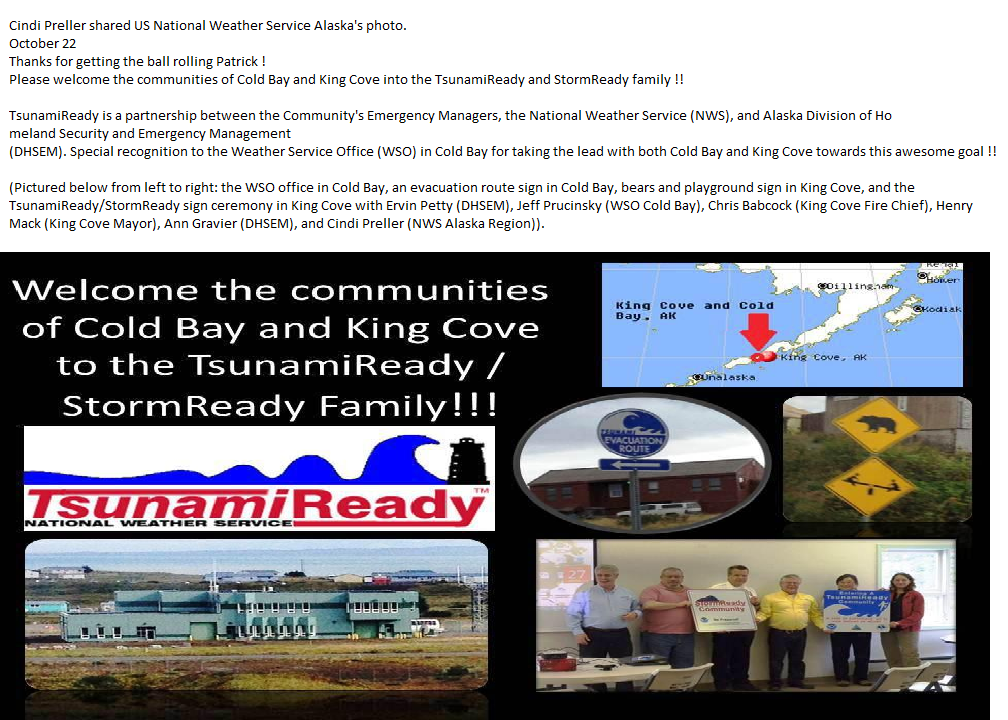
On a side note...congrats to Cold Bay and King Cove on getting Tsunami Ready and Storm Ready. More information and other interesting stories...about different events/forecasts...can be found on the page below. http://www.facebook....vice.Alaska.gov
-
Alaska/Western Canada obs and discussion
patrick7032 replied to patrick7032's topic in Central/Western States
One of the videos from when I launched a radiosonde in moderate winds at Cold Bay before getting promoted/transferring to Texas. At the time we had southeast winds of 38G46KT. -
Alaska/Western Canada obs and discussion
patrick7032 replied to patrick7032's topic in Central/Western States
You're correct bud....975mb there is like 1002mb in the midwest....wait for the winter when you get the sub 950 or even 940mb lows and have Hurricane Force warning in the Bering. Remember one last year we had winds SE 70kt gusts to 80kt seas of 34 building to 42 feet. You're gonna have a blast forecasting those storms. -
Alaska/Western Canada obs and discussion
patrick7032 replied to patrick7032's topic in Central/Western States
Been loving the heat....had several days of afternoon storms too. This week will be another hot one as temps will be in the 103-107 range. Norm is 96....but with the mid level high over the pandhandle....what can ya do. -
Alaska/Western Canada obs and discussion
patrick7032 replied to patrick7032's topic in Central/Western States
You'll enjoy it bud. You're up there and now I'm down here. Seems we tend to move about the same time....lol. -
Alaska/Western Canada obs and discussion
patrick7032 replied to patrick7032's topic in Central/Western States
PUBLIC INFORMATION STATEMENT NATIONAL WEATHER SERVICE COLD BAY AK 708 AM AKDT TUE APR 3 2012 ...A RECORD MONTH IT WAS IN COLD BAY... THE MONTH OF MARCH WAS ONE OF THE COLDEST AND SNOWIEST MONTHS IN RECENT MEMORY. THERE WERE 9 RECORDS SET DURING THE MONTH INCLUDING 7 OF THEM FOR TEMPERATURE. THE MONTH ENDED WITH 43.3 INCHES OF SNOWFALL WHICH WAS JUST 1.2 INCHES SHORT OF THE ALL TIME RECORD FOR THE MONTH. THIS BROUGHT THE SEASONAL SNOWFALL TOTAL TO 108.5 INCHES WHICH PLACES THIS YEAR IN SECOND PLACE. THE SEASONAL SNOWFALL RECORD IS 115.9 INCHES WHICH WAS SET DURING THE 1983-84 SEASON. RECORDS FOR THE MONTH: DATE: CATEGORY: NEW RECORD: MONTHLY PRECIPITATION 7.13 INCHES MARCH 2ND SNOWFALL 7.40 INCHES MARCH 13TH LOW TEMPERATURE +3 DEG F MARCH 13TH LOW MAXIMUM TEMPERATURE +15 DEG F MARCH 19TH LOW MAXIMUM TEMPERATURE +11 DEG F MARCH 20TH LOW TEMPERATURE +5 DEG F MARCH 20TH LOW MAXIMUM TEMPERATURE +13 DEG F MARCH 21ST LOW MAXIMUM TEMPERATURE +11 DEG F MARCH 22ND LOW TEMPERATURE - 3 DEG F $$ DOLL APR 12 -
Alaska/Western Canada obs and discussion
patrick7032 replied to patrick7032's topic in Central/Western States
Okay enough is enough....we have more than doubled our monthly snowfall and the month is half over....a record low temperature earlier in the month....and for the second time this month this.... SXAK78 PACD 201005 RERCDB RECORD EVENT REPORT NATIONAL WEATHER SERVICE COLD BAY AK 205 AM AKDT TUE MAR 20 2012 ...RECORD LOW MAXIMUM TEMPERATURE SET AT THE STATE AIRPORT IN COLD BAY... A NEW RECORD LOW MAXIMUM TEMPERATURE WAS SET YESTERDAY IN COLD BAY WHEN THE MERCURY ONLY ROSE TO 11 DEGREES ABOVE ZERO BREAKING THE OLD RECORD OF 15 DEGREES ABOVE ZERO. $$ DOLL MAR 12 -
Alaska/Western Canada obs and discussion
patrick7032 replied to patrick7032's topic in Central/Western States
Glad we can help....although I'm hoping to be back in the lower 48 soon....been bidding on jobs. -
Alaska/Western Canada obs and discussion
patrick7032 replied to patrick7032's topic in Central/Western States
After a relatively warm month here in most of Alaska (even the southwest in central interior spent a week in the 30s-40s) a return to a wet and snow pattern looks to continue. Here in Cold Bay for the month of February we had 6.01 inches of precip which is well above or normal of 3.06. we also had 27.3 inches of snow which again was well above the 12.9 average. As we enjoyed the warmer weather especially last week a large chunk of energy dived down into the lower 48 which helped the Tornado outbreak. After the nice respite it looks like the pattern is begging to "reload" up here and perhaps "calm down" some in the lower 48 as the jet pattern changes..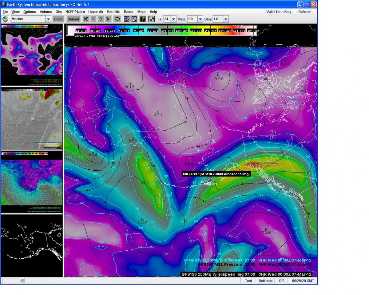
-
Alaska/Western Canada obs and discussion
patrick7032 replied to patrick7032's topic in Central/Western States
Nice pics MTBLANC....every month I fly from Cold Bay, Alaska to Detroit, Michigan and the last return trip at about 1am and 36,000 ft looking towards your area seen a great display. Listed below are some links to the pictures/movies of Northern Lights in Alaska this past few weeks. http://www.facebook.com/profile.php?id=100000552091561&ref=tn_tnmn#!/media/set/?set=a.301604916559575.83400.137686999618035&type=3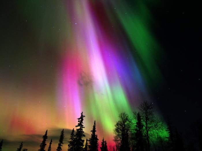
-
Alaska/Western Canada obs and discussion
patrick7032 replied to patrick7032's topic in Central/Western States
-
Alaska/Western Canada obs and discussion
patrick7032 replied to patrick7032's topic in Central/Western States
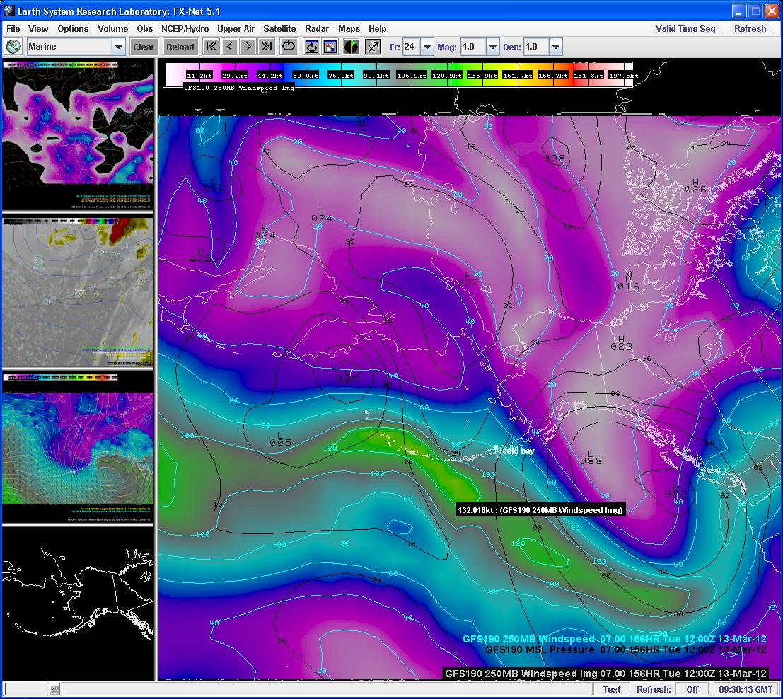
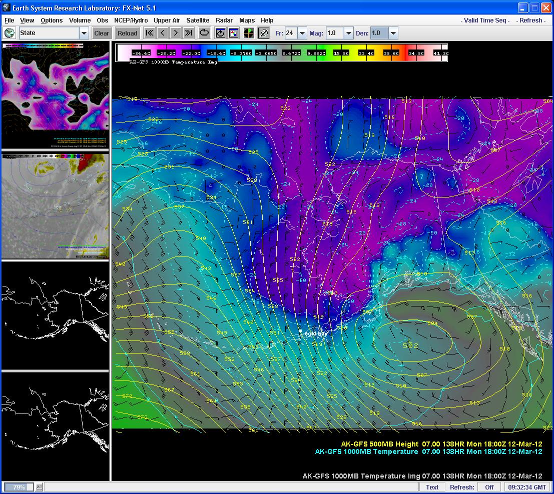
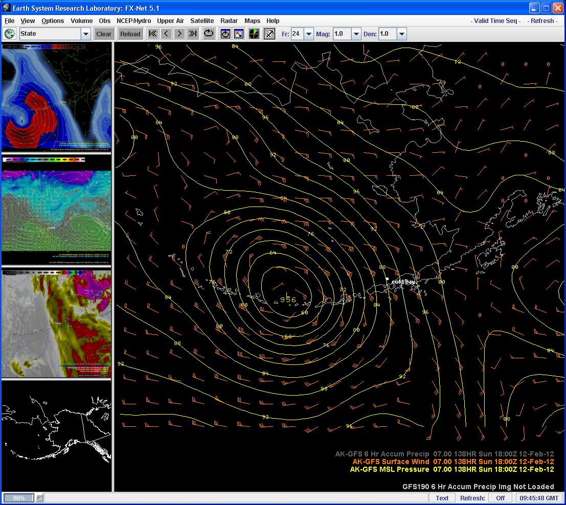
Interesting weather pattern continues for the Aleutian chain....and quite an interesting pattern at 500 mb....have another storm impinging on the Alaska peninsula with another very respectable system expected Sunday....fun times out here and hopefully some of the energy will spill south in time to give the lower 48 some much needed snow.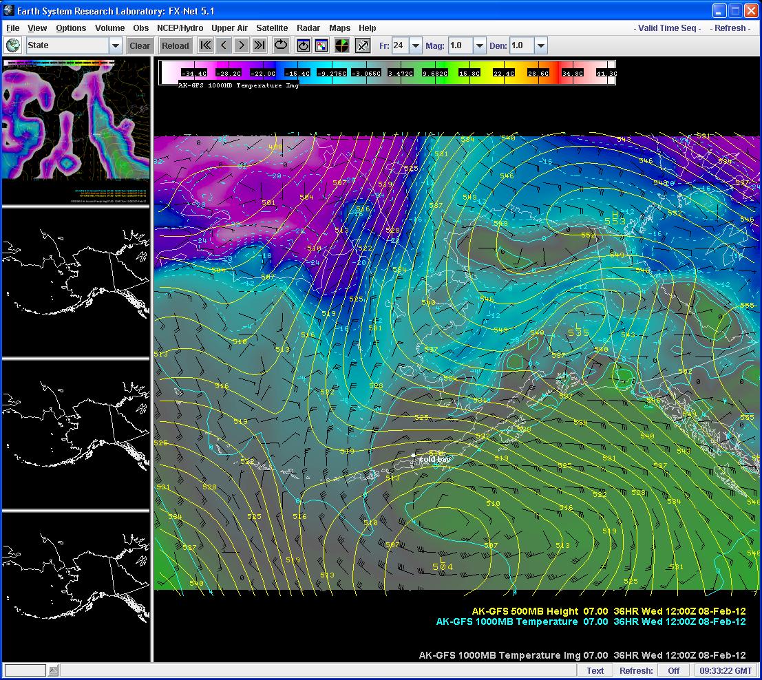
-
Alaska/Western Canada obs and discussion
patrick7032 replied to patrick7032's topic in Central/Western States
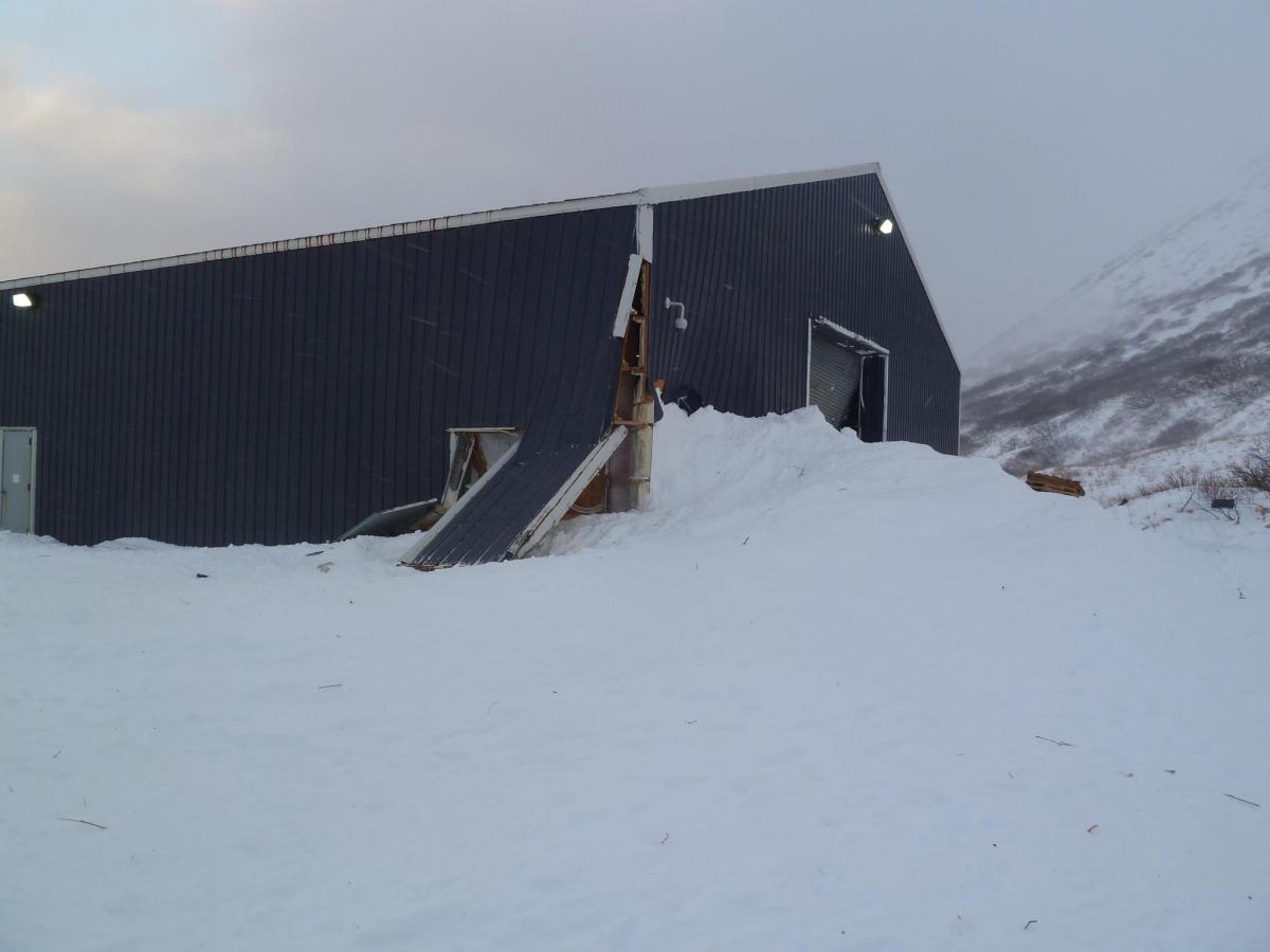
After a month where we averaged 8.9 degrees below normal on highs and 11.0 degrees below normal on lows with 4 records set for snow....low temps....and a record low minimum high....this also involved 10 BLIZZARD WARNINGS and 2 HIGH WIND WARNINGS (out here we don't issue HIGH WIND WARNINGS in the Aleutian chain until they meet hurricane force criteria)....you would think it may calm down some....nope....we had a blizzard Tuesday where winds peaked at 89 with damage to a building (see attached pictures)....then another blizzard Thursday with a record low temp of 1 above....the blizzard lasted 18 hours....then a 6 hour break before a 48 hour long storm with winds of 45-70....looks like our anemometer on the ASOS got damaged from it as it's down (not working for over a day now)....love how active it has been as the shifts go by fast.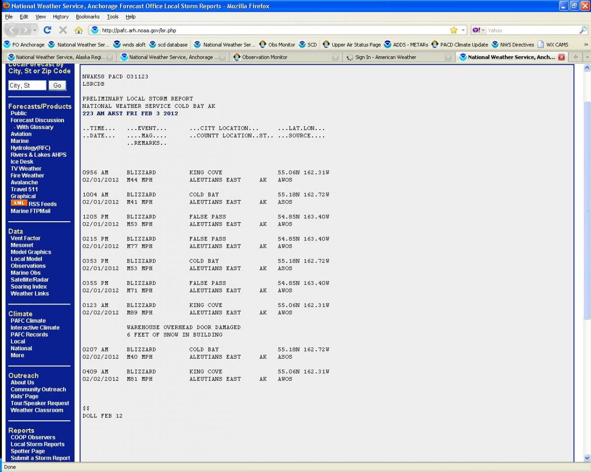
-
Alaska/Western Canada obs and discussion
patrick7032 replied to patrick7032's topic in Central/Western States
One word....BBBRRRR.... WWAK41PAFG_AKZ203 ----------------- AKZ203-261500- /X.CON.PAFG.WC.W.0004.000000T0000Z-120126T1500Z/ CENTRAL BEAUFORT SEA COAST- INCLUDING...NUIQSUT...PRUDHOE BAY...ALPINE...DEADHORSE...KUPARUK 946 PM AKST WED JAN 25 2012 ...WIND CHILL WARNING REMAINS IN EFFECT UNTIL 6 AM AKST THURSDAY... A WIND CHILL WARNING REMAINS IN EFFECT UNTIL 6 AM AKST THURSDAY. * LOCATION...ALONG THE COAST. * WIND CHILL VALUES...TO 85 BELOW. * WINDS...WEST TO 15 MPH. * TIMING...WIND CHILLS WILL BECOME LESS HARSH THURSDAY MORNING AS THE WINDS DECREASE. * IMPACTS...EXPOSED FLESH WILL FREEZE IN LESS THAN TEN MINUTES RESULTING IN FROSTBITE. PRECAUTIONARY/PREPAREDNESS ACTIONS... A WIND CHILL WARNING MEANS THAT DANGEROUSLY LOW WIND CHILLS WITH SUSTAINED WIND SPEEDS OF 15 MPH OR MORE ARE OCCURRING OR EXPECTED. IF OUTDOORS...COVER EXPOSED SKIN TO PREVENT FROSTBITE. && $$ FPAK51PAFG_AKZ203 ----------------- AKZ203-261545- CENTRAL BEAUFORT SEA COAST- INCLUDING...NUIQSUT...PRUDHOE BAY...ALPINE...DEADHORSE...KUPARUK 334 PM AKST WED JAN 25 2012 ...WIND CHILL WARNING IN EFFECT UNTIL 6 AM AKST THURSDAY... .TONIGHT...INCREASING CLOUDS. PATCHY ICE FOG. LOWS 50 TO 55 BELOW. SOUTHWEST WINDS 10 TO 20 MPH...STRONGEST NEAR THE COAST. WIND CHILL TO 85 BELOW NEAR THE COAST. .THURSDAY...MOSTLY CLOUDY. PATCHY ICE FOG. HIGHS 40 TO 45 BELOW. WEST WINDS 10 TO 20 MPH. WIND CHILL TO 85 BELOW IN THE MORNING ALONG THE COAST. .THURSDAY NIGHT...MOSTLY CLOUDY. SCATTERED FLURRIES IN THE EVENING. PATCHY FOG THROUGH THE NIGHT. LOWS 40 TO 45 BELOW. WEST WINDS AROUND 15 MPH. WIND CHILL TO 70 BELOW. .FRIDAY...MOSTLY CLOUDY. PATCHY FOG. HIGHS 30 TO 35 BELOW. SOUTHWEST WINDS AROUND 15 MPH. .FRIDAY NIGHT...MOSTLY CLOUDY. LOWS 40 TO 45 BELOW. SOUTHWEST WINDS AROUND 15 MPH. .SATURDAY...MOSTLY CLOUDY. HIGHS NEAR 40 BELOW. .SATURDAY NIGHT...CLOUDY. LOWS NEAR 45 BELOW. .SUNDAY...MOSTLY CLOUDY. HIGHS NEAR 40 BELOW. .SUNDAY NIGHT...MOSTLY CLOUDY. LOWS NEAR 45 BELOW. .MONDAY...MOSTLY CLOUDY. HIGHS NEAR 35 BELOW. .MONDAY NIGHT...MOSTLY CLOUDY. LOWS NEAR 40 BELOW. .TUESDAY...MOSTLY CLOUDY. HIGHS NEAR 35 BELOW. .TUESDAY NIGHT...MOSTLY CLOUDY. LOWS NEAR 40 BELOW. .WEDNESDAY...MOSTLY CLOUDY. HIGHS NEAR 35 BELOW.