

Jackstraw
-
Posts
2,268 -
Joined
-
Last visited
Content Type
Profiles
Blogs
Forums
American Weather
Media Demo
Store
Gallery
Posts posted by Jackstraw
-
-
Kinda crazy how the Canuk is just locked on to the streamer off of Lake Michigan. None of the other models are nearly as robust. Will be interesting to see how that pans out. Also, has the northern stream energy even been sampled yet?

-
4 hours ago, Chinook said:
No matter what happens, I will try to post some 4- or 5-day loops of GFS 500mb plot, GFS surface/precip, NWS surface analysis, possibly GFS 700-400mb moisture, possibly IR satellite pics, possibly regional radar for Ohio.

-
 1
1
-
-
Boundary temp hell we all will be in (insert Yoda emoji)
-
 3
3
-
-
Saw that. Euro is a wash, rinse, repeat at the surface from the impending mess. Could hardly buy any App runners the last couple years. Be a shame to waste 'em all this early lol.
-
1
-
-
Save some gas. Just head up to the west slope mountains NC/TN even WV. Less chance of slop with altitude and much much better scenery lol.
-
1
-
-
I'm taking my streamer and running with it


-
1
-
2
-
-
2 hours ago, Hoosier said:
Seems like it might be setting up the ol foreign vs American model camps, especially if the 00z Euro looks anything like the 18z run.
Think you're correct. As of now looks like the Euro/Canuk camp vs the GFS/NAM camp with the rebellious UKIE not buying any of it lol.
-
On 11/26/2020 at 5:33 PM, IWXwx said:
If that fetch plays out, you'll get in on the good stuff. It's been a few years since I've seen streamers all the way to CVG. I remember some LES from Lake Michigan hitting DAY a couple of years ago.
Now that's a streamer off the lake lol...

-
1
-
-
The Canuk has been much more consistent with it's own H5 forecast for midnight Monday than than the GFS and even the Euro. Very little deviation since Wed. Not saying it's right just seems more consistent against itself.
-
00z GFS is pretty wonky. Bounces that surface low around like its in a pachinko machine.
-
Euro also trying to give the western part of the sub some sloppy love right behind this one lol.

-
1
-
-
Euro slop fest for sure. More typical app runner kitchen sink storm like we're used to lol.
-
56 minutes ago, Hoosier said:
I did look at it a bit, and yes, it would not be your classic colder LES event. The thermodynamics are mediocre, but the duration and at least potential for a very long fetch could still result in some pretty decent amounts somewhere imo. And likely to spread well inland given the robust low level flow.
Can maybe see it on Kutchera ratio. Nice stripe of low ratio cement off the lake on this mornings GFS.

-
1
-
-
1 minute ago, Stebo said:
The Euro whoo boy. It stalls the low east of here and just keeps dumping snow. This was probably one of the wilder runs I have ever seen.
Definitely a tick up for you!
-
Euro looks a bit slower and weaker than it was 00Z last night. It's cutting off from the northern jet much later this run. A lot of those crazy totals on the previous runs were a perfect long lasting northerly fetch along almost the entire length of a warm Lake Michigan for upwards of 36 hours. LES on steroids. This run, still anaomolis for this time of year, makes a little more sense, to me anyways. GFS is moving closer to this also. I think in the end could see a foot in some places maybe a more wide spread 6-10. Kuchera ratios are lower so a percentage could be sloppy.


-
2
-
-
Extended has been and is still looking parched....

-
1
-
-
13 hours ago, SandySurvivor said:
Always cool to get to the “s” storm on the list but this storm paled in comparison to the last time we had an “s” storm which was sandy
after extensively reviewing damage photos and storm reports it’s clear that damage from sally is minimal compared to sandy
That's because This Old House has only been on air for 41 years. Norm (screw Vila, freakin Home Depot sellout) tried but couldn't rebuild the entire NE US. Learn how to build houses in Yankeeville like they do in the south instead of screwing up the hot dog and blindly following a never gonna happen Jets resurrection (They died with the AFL, give it up!)
")
End Sally banter here? lol
-
45 minutes ago, JakkelWx said:
Waters still very cold off the Gulf of Mexico coast as a result of Laura's upwelling.
Wish I could make meme's but there's Penguins in Antarctica who've strapped Evinrudes to those collapsed ice shelves and are heading north to the Gulf
-
3
-
-
4 hours ago, Calderon said:
It's an internet board that I've been part of since EasternUSWX, and I'm also 33 forecasting in an active war zone. I really don't care on here.
I gotcha. Maybe I'm just getting old, I mean I still have maps with thumb tack holes in them from the 80's. I tracked Hugo and Andrew on a thumbtack map, even took the map with me to Kendall trying to get my uncle to leave at the time. Yes, I thumb tacked map storms every day listening to the updates on the radio of what y'all see on the NHC website today. The analogy of I walked to school through feet of snow applies lol.
The only thing that bothers me is when bandwagon riders jump a thread with statements like "is that an eye? "Looks like its weakening" or "it's gonna blow up".
Back yourself up. Jumping on a storm thread and being to lazy to go back 6 10 pages to either learn or see what was discussed is just that, lazy. You disrespect the others that have been a little more diligent than you. That discussion probably has already been had, learn from it, then throw your opinion. Scientific method for the masses if you will.
Do it like me. If I fall asleep, when I wake up and have time for the board I will scorch a candle and spend 30 minutes reading what I missed. Most of us aren't experts which is why we have these boards. The fun and challenge is in the learning at least to me.
Ive learned more in life by it being pointed out I'm a dumbass at times than getting a cookie the few times I'm right
-
3
-
 1
1
-
-
Top it all off TS "Karina" just formed in the E Pacific. Wth? This year is just getting too weird and I like weird.
-
Wave train is chuggin'

-
Just my armchair opinion as we move into the peak over the next week but I've said it before this season. The pattern over the Conus since about mid July has been anything but normal. Up here in the lower great lakes where I am we've had 4 nights below 50 and a string of sub 80 degree days in August, that's kinda nuts. The trough anomalies - placement, strength and depth have been consistent for the last 6 weeks, consistently from the upper midwest down through TX. We're moving into a similar pattern again over the next 10 days. We do have a bit of weaker ridging over the Atlantic currently but there's signals in the ensembles for that to be temporary and begin to build a stronger WAR by the end of the week. Anything that develops off of Africa quickly will more than likely be shark food. But weaker waves that would be less likely to feel any weakness in the ridging prior to 50W could very well roll into a favorable environment and steering to threaten the states I especially think the GOM is far from done if this Conus pattern persists and we possibly could see an abnormal increase in the number of GOM storms by seasons end. As WxWatcher007 has pointed out the tepid west pacific season just hasn't been energizing the northern jet and this has enabled the pattern over the Conus to be rather stale, allowing some rather stout stubborn ridging in the SW and deeper slow moving troughing over the central US. If we don't get some west pac energy rounding into the northern jet over the conus we could still get into these slow pattern locks like we've seen.
Just based on that rather weak analysis lol, to me, I think the chances of any storms that either make it to or begin organizing past 50 or 60W and south of 20N the possibility of any affecting the states is higher than normal unless we see a substantial pattern change over the Conus. Where the troughing is currently settling it's going to be able to draw anything north into the GOM or pull something into the EC. It would be nice if the troughs were digging 3 or 4 hundred miles farther E providing a shield for the EC and driving southern storms west. West coast of Fl.'s season is coming up in a few weeks, end of Sept. into Oct. If the pattern shift waits until then it could get interesting. I'm not a landfall wisher by any means, just my uneducated guess moving forward.
And one more thing, where the hell are the TUTT's this year? Anyway sorry for the long post, takes me a while to form an armchair opinion nowadays
-
2
-
-
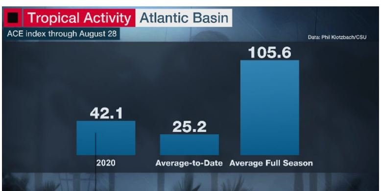
Currently 2020 is the 9th most active season through the end of August in the satellite era when using ACE index with the number at about 42 so far. With "peak" still a week away and initial ACE forecasts of 130 to 160 there's still a lot of time for some big things to happen if those forecasts pan out. One thing I'm thinking about is we are just now entering "major hurricane season". The higher percentage of majors occur from now moving forward. Sure it's not been exciting from a "headlines" standpoint so far but as others have said we're just now heading into the active period that statistically has the highest threat of stronger storms. Now if we do get 3 or 4 more majors with an ACE of 150 for the season this year along with weaker storms and the majors all are fish,will folks still be saying this season's a bust? Probably lol......
Cat 3 by month

Cat 4 by month

Cat 5 by month

-
Winter 2020-21 Medium/Long Range Discussion
in Lakes/Ohio Valley
Posted
When Cyclone and Hawkeye are zzzzz it usually means those of us that live in the east ghetto around I70 have something to look forward to lol.