

Jackstraw
-
Posts
2,383 -
Joined
-
Last visited
Content Type
Profiles
Blogs
Forums
American Weather
Media Demo
Store
Gallery
Posts posted by Jackstraw
-
-
1 minute ago, Stebo said:
The Euro whoo boy. It stalls the low east of here and just keeps dumping snow. This was probably one of the wilder runs I have ever seen.
Definitely a tick up for you!
-
Euro looks a bit slower and weaker than it was 00Z last night. It's cutting off from the northern jet much later this run. A lot of those crazy totals on the previous runs were a perfect long lasting northerly fetch along almost the entire length of a warm Lake Michigan for upwards of 36 hours. LES on steroids. This run, still anaomolis for this time of year, makes a little more sense, to me anyways. GFS is moving closer to this also. I think in the end could see a foot in some places maybe a more wide spread 6-10. Kuchera ratios are lower so a percentage could be sloppy.


-
 2
2
-
-
Extended has been and is still looking parched....

-
1
-
-
13 hours ago, SandySurvivor said:
Always cool to get to the “s” storm on the list but this storm paled in comparison to the last time we had an “s” storm which was sandy
after extensively reviewing damage photos and storm reports it’s clear that damage from sally is minimal compared to sandy
That's because This Old House has only been on air for 41 years. Norm (screw Vila, freakin Home Depot sellout) tried but couldn't rebuild the entire NE US. Learn how to build houses in Yankeeville like they do in the south instead of screwing up the hot dog and blindly following a never gonna happen Jets resurrection (They died with the AFL, give it up!)
")
End Sally banter here? lol
-
45 minutes ago, JakkelWx said:
Waters still very cold off the Gulf of Mexico coast as a result of Laura's upwelling.
Wish I could make meme's but there's Penguins in Antarctica who've strapped Evinrudes to those collapsed ice shelves and are heading north to the Gulf
-
 3
3
-
-
4 hours ago, Calderon said:
It's an internet board that I've been part of since EasternUSWX, and I'm also 33 forecasting in an active war zone. I really don't care on here.
I gotcha. Maybe I'm just getting old, I mean I still have maps with thumb tack holes in them from the 80's. I tracked Hugo and Andrew on a thumbtack map, even took the map with me to Kendall trying to get my uncle to leave at the time. Yes, I thumb tacked map storms every day listening to the updates on the radio of what y'all see on the NHC website today. The analogy of I walked to school through feet of snow applies lol.
The only thing that bothers me is when bandwagon riders jump a thread with statements like "is that an eye? "Looks like its weakening" or "it's gonna blow up".
Back yourself up. Jumping on a storm thread and being to lazy to go back 6 10 pages to either learn or see what was discussed is just that, lazy. You disrespect the others that have been a little more diligent than you. That discussion probably has already been had, learn from it, then throw your opinion. Scientific method for the masses if you will.
Do it like me. If I fall asleep, when I wake up and have time for the board I will scorch a candle and spend 30 minutes reading what I missed. Most of us aren't experts which is why we have these boards. The fun and challenge is in the learning at least to me.
Ive learned more in life by it being pointed out I'm a dumbass at times than getting a cookie the few times I'm right
-
3
-
 1
1
-
-
Top it all off TS "Karina" just formed in the E Pacific. Wth? This year is just getting too weird and I like weird.
-
Wave train is chuggin'

-
Just my armchair opinion as we move into the peak over the next week but I've said it before this season. The pattern over the Conus since about mid July has been anything but normal. Up here in the lower great lakes where I am we've had 4 nights below 50 and a string of sub 80 degree days in August, that's kinda nuts. The trough anomalies - placement, strength and depth have been consistent for the last 6 weeks, consistently from the upper midwest down through TX. We're moving into a similar pattern again over the next 10 days. We do have a bit of weaker ridging over the Atlantic currently but there's signals in the ensembles for that to be temporary and begin to build a stronger WAR by the end of the week. Anything that develops off of Africa quickly will more than likely be shark food. But weaker waves that would be less likely to feel any weakness in the ridging prior to 50W could very well roll into a favorable environment and steering to threaten the states I especially think the GOM is far from done if this Conus pattern persists and we possibly could see an abnormal increase in the number of GOM storms by seasons end. As WxWatcher007 has pointed out the tepid west pacific season just hasn't been energizing the northern jet and this has enabled the pattern over the Conus to be rather stale, allowing some rather stout stubborn ridging in the SW and deeper slow moving troughing over the central US. If we don't get some west pac energy rounding into the northern jet over the conus we could still get into these slow pattern locks like we've seen.
Just based on that rather weak analysis lol, to me, I think the chances of any storms that either make it to or begin organizing past 50 or 60W and south of 20N the possibility of any affecting the states is higher than normal unless we see a substantial pattern change over the Conus. Where the troughing is currently settling it's going to be able to draw anything north into the GOM or pull something into the EC. It would be nice if the troughs were digging 3 or 4 hundred miles farther E providing a shield for the EC and driving southern storms west. West coast of Fl.'s season is coming up in a few weeks, end of Sept. into Oct. If the pattern shift waits until then it could get interesting. I'm not a landfall wisher by any means, just my uneducated guess moving forward.
And one more thing, where the hell are the TUTT's this year? Anyway sorry for the long post, takes me a while to form an armchair opinion nowadays
-
2
-
-
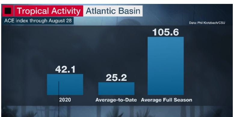
Currently 2020 is the 9th most active season through the end of August in the satellite era when using ACE index with the number at about 42 so far. With "peak" still a week away and initial ACE forecasts of 130 to 160 there's still a lot of time for some big things to happen if those forecasts pan out. One thing I'm thinking about is we are just now entering "major hurricane season". The higher percentage of majors occur from now moving forward. Sure it's not been exciting from a "headlines" standpoint so far but as others have said we're just now heading into the active period that statistically has the highest threat of stronger storms. Now if we do get 3 or 4 more majors with an ACE of 150 for the season this year along with weaker storms and the majors all are fish,will folks still be saying this season's a bust? Probably lol......
Cat 3 by month

Cat 4 by month

Cat 5 by month

-
-
I can guarantee, there's one guy whose got the bow of his airboat chained to a big 'ol Cypress with the ass facing south cranked at full throttle with Cranky next to him wearing goggles and a bicycle helmet yelling "keep it up, we;re shearing the hell out of it!" Now that would be a Cohen Brothers ending lol.

-
1
-
-
Real landfall beginning
-
1 minute ago, the ghost of leroy said:
jeff p is such a weiner
dont get me wrong, i am going to keep his stream on but he's just embellishing the heck out of these 40mph winds in lake charles rn
like...why do that? in an hour you're gonna be getting pants shitting level video...
He learned from early Cantore, have a guy out of camera shot with a hose flooding your feet and shaking the bushes behind ya lol
-
There's gonna be a blizzard of the millenium this winter and right when it hits 300 tapatalk posters are gonna say they found 2 snowflakes just alike. I won't mention what forum that likely is
-
9 minutes ago, the ghost of leroy said:
smoked a couple bowls and hit the dog park...did i miss anything good?
Ha! So did I, gone for an hour with the dogs went back on the main thread, 200+ new posts??? Can't see the forest for the trees shit there lol.
-
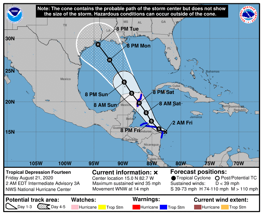
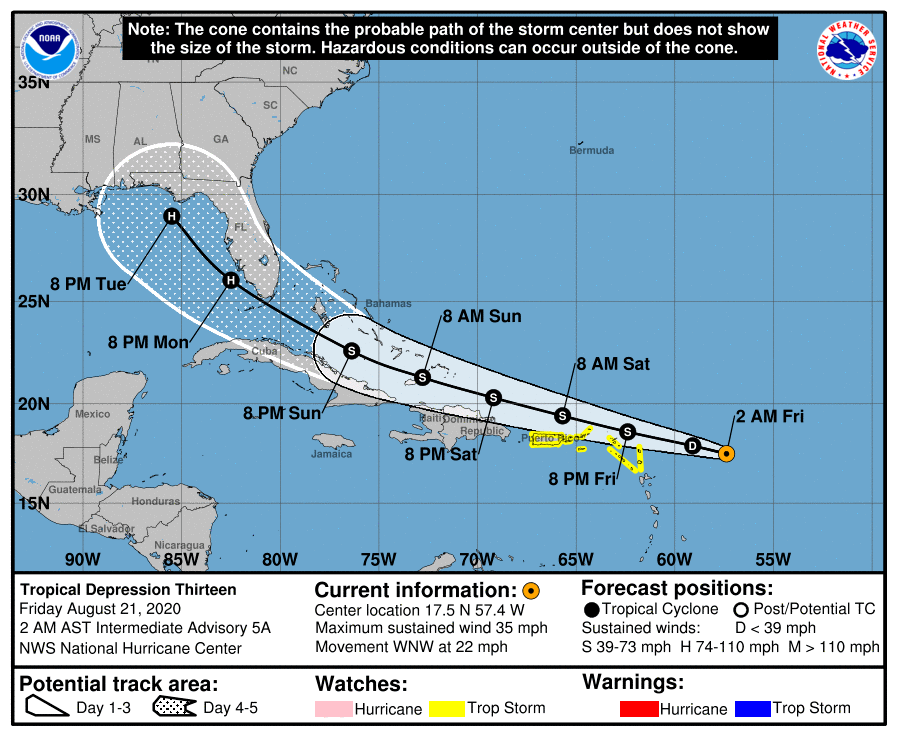
Well, we're a far cry from the double whammy simultaneous scenario forecasted early Friday morning. Granted, a fatally injured Marco is dragging himself to his original forecasted LF point like a tearjerker ending in a Hollywood survival movie. Another reason to be patient with these things 5 days out and we're still not done. Think there's still time for 1 or 2 more surprises from Laura. As I thought these storms have not disappointed from a tracking standpoint.
Go Marco go, you can do it!
-
1
-
-
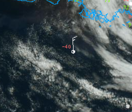
Think there's still an elongated LLC moving up towards LA, can kinda see it on shortwave IR, but it sure looks like the mid level vort got scooped and is taking off NNE. Could let that ridge to the east build in faster. There seems to be some pretty deep easterly flow south of Marco back down around the Yucatan. Weak strugglers gotta love 'em, or hate 'em if you're at the NHC.
https://www.star.nesdis.noaa.gov/GOES/floater_band.php?stormid=AL142020&band=07&length=12
-
1
-
-
Yeah, looks like maybe the speedmax on the east side of that trough is a little farther east and taking a little longer to lift NE cutting Marco at his 500mb knees. We could be looking at a chugga chugga choo choo 50KT swirl moving NW by morning. Or not, stranger things have happened lol.
-
SAL/dry air has shut down anything currently coming across/off Africa but there's 3 fairly stout waves following this last episode of very dry air. It's a wait and see if any can make a run into the Atlantic towards the end of the week. Also, link to a sat view of a pretty strong dust storm over the west central Sahara I thought was cool
http://tropic.ssec.wisc.edu/real-time/sal/msg_rgbdust/movies/msg_rgbdust.html
-
2
-
-
I don;t know if it's the prolonged lack/reduction of aircraft data across the CONUS or for that matter across the Atlantic, but the models have been off the past 4 or 5 months more than usual, especially forecasting upper level features, which usually the globals have a general agreement inside 120 hours. I know up where I'm at they've been s#%t outside 48 hours. I think someone whose across the pond posted in one of the threads they've been crap over there also. I posted Thursday that the next 7 days were going to be a challenge simply because what the models were spitting out I've never seen. Also none of them were consistent with upper CONUS features earlier in the week, not even focusing on the potential storms themselves at the time. Just habit from when I lived in the Clearwater area for 11 years and whenever I saw models pushing something into the GOM the first thing I looked at was what the forecast was over the CONUS. I do like tracking weaker storms because I think there's a lot to be learned there. I've seen storms do crazy things in 30 years so no matter how good the models have gotten anything they spit out comes with some suspicion, but this year has been kinda nuts. Maybe its like Vortex95 said, too much of a good thing lol. I know one thing, when the CMC is running a tight race over time on verification scores with the big boy's somethings up.

Edit: Sorry thought I was in the 2020 Hurricane season thread

-
1
-
-
9 minutes ago, vortex95 said:
Problem we are seeing with Macro is similar to Laura, just not quite as bad. Note how recently convection waned over the center, re-fired in a small blob, and now is waning again. That's a sign of dry air entertainment. Also, the larger more intense convective blob just to its NE -- surrounding large blobs like this discrete from the center are not good b/c that area will collapse and send out outflow at low levels into the LLCC. Also, it interferes with the anticyclonic smooth outflow aloft that tries to get established over the central convection.
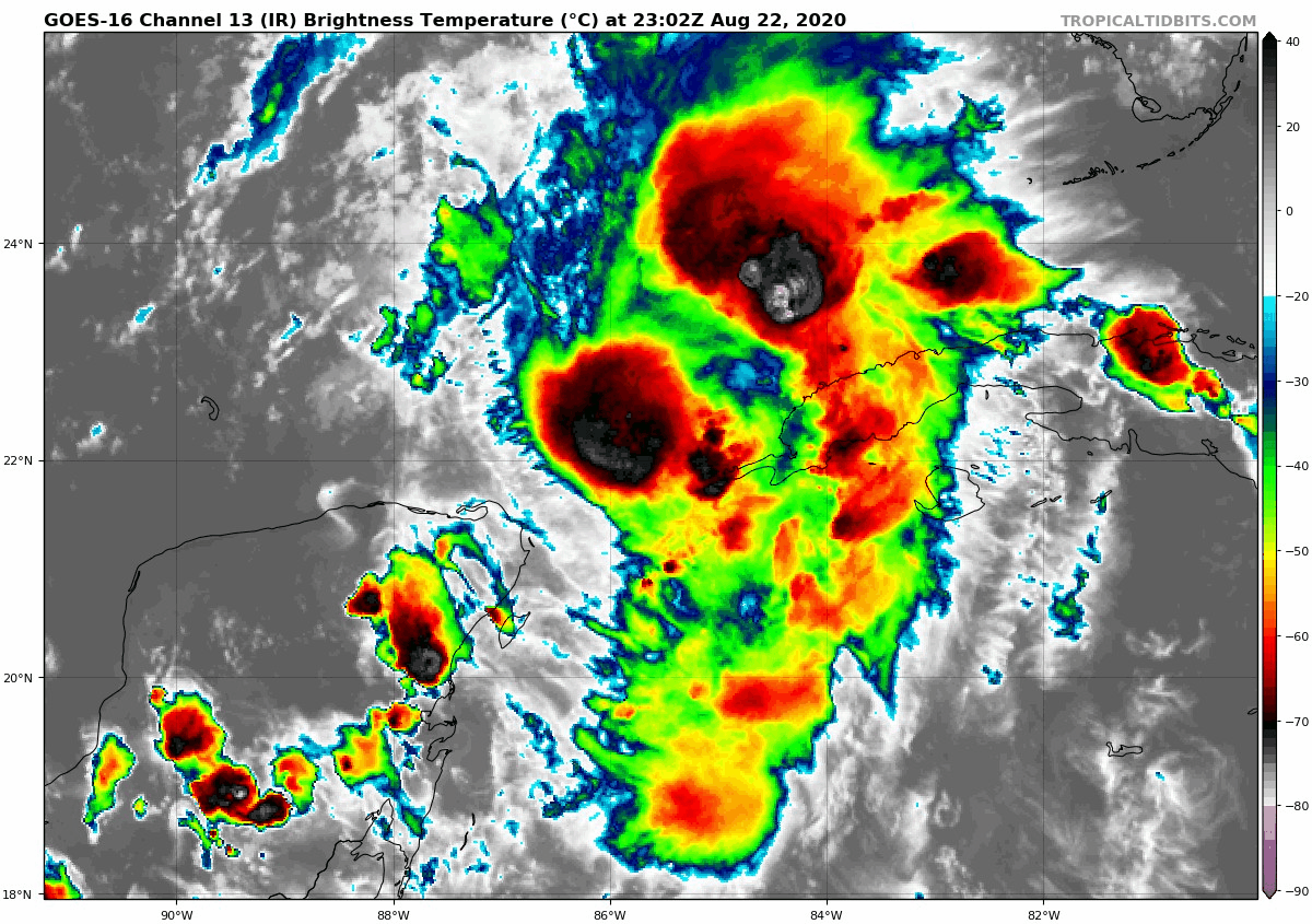
Gotcha, thanks for that. With all of the focus on the shear it's easy to lose focus on some of the other factors.
-
I'd like to see them do a drop from 10k on the NW side of the storm before they leave, get a bit of a snapshot of mid to upper level shear velocities/direction.
-
Dew's rising significantly at flt level in that drop. SHIPS thinks a decent chance at another 25KT over the next 24-36 hours.....
SHIPS Prob RI for 20kt/ 12hr RI threshold= 36% is 7.3 times climatological mean ( 5.0%) SHIPS Prob RI for 25kt/ 24hr RI threshold= 66% is 6.0 times climatological mean (10.9%) SHIPS Prob RI for 30kt/ 24hr RI threshold= 44% is 6.4 times climatological mean ( 6.9%) SHIPS Prob RI for 35kt/ 24hr RI threshold= 33% is 8.4 times climatological mean ( 3.9%) SHIPS Prob RI for 40kt/ 24hr RI threshold= 20% is 8.1 times climatological mean ( 2.5%) SHIPS Prob RI for 45kt/ 36hr RI threshold= 45% is 9.7 times climatological mean ( 4.6%) SHIPS Prob RI for 55kt/ 48hr RI threshold= 35% is 7.6 times climatological mean ( 4.6%) SHIPS Prob RI for 65kt/ 72hr RI threshold= 20% is 3.8 times climatological mean ( 5.2%)-
1
-

November 30-December 2 *Potential* Winter Storm
in Lakes/Ohio Valley
Posted
Can maybe see it on Kutchera ratio. Nice stripe of low ratio cement off the lake on this mornings GFS.