

Jackstraw
-
Posts
2,268 -
Joined
-
Last visited
Content Type
Profiles
Blogs
Forums
American Weather
Media Demo
Store
Gallery
Posts posted by Jackstraw
-
-
Real landfall beginning
-
1 minute ago, the ghost of leroy said:
jeff p is such a weiner
dont get me wrong, i am going to keep his stream on but he's just embellishing the heck out of these 40mph winds in lake charles rn
like...why do that? in an hour you're gonna be getting pants shitting level video...
He learned from early Cantore, have a guy out of camera shot with a hose flooding your feet and shaking the bushes behind ya lol
-
There's gonna be a blizzard of the millenium this winter and right when it hits 300 tapatalk posters are gonna say they found 2 snowflakes just alike. I won't mention what forum that likely is
")
-
9 minutes ago, the ghost of leroy said:
smoked a couple bowls and hit the dog park...did i miss anything good?
Ha! So did I, gone for an hour with the dogs went back on the main thread, 200+ new posts??? Can't see the forest for the trees shit there lol.
-
Well, we're a far cry from the double whammy simultaneous scenario forecasted early Friday morning. Granted, a fatally injured Marco is dragging himself to his original forecasted LF point like a tearjerker ending in a Hollywood survival movie. Another reason to be patient with these things 5 days out and we're still not done. Think there's still time for 1 or 2 more surprises from Laura. As I thought these storms have not disappointed from a tracking standpoint.
Go Marco go, you can do it!

-
 1
1
-
-
Think there's still an elongated LLC moving up towards LA, can kinda see it on shortwave IR, but it sure looks like the mid level vort got scooped and is taking off NNE. Could let that ridge to the east build in faster. There seems to be some pretty deep easterly flow south of Marco back down around the Yucatan. Weak strugglers gotta love 'em, or hate 'em if you're at the NHC.
https://www.star.nesdis.noaa.gov/GOES/floater_band.php?stormid=AL142020&band=07&length=12
-
 1
1
-
-
Yeah, looks like maybe the speedmax on the east side of that trough is a little farther east and taking a little longer to lift NE cutting Marco at his 500mb knees. We could be looking at a chugga chugga choo choo 50KT swirl moving NW by morning. Or not, stranger things have happened lol.
-
SAL/dry air has shut down anything currently coming across/off Africa but there's 3 fairly stout waves following this last episode of very dry air. It's a wait and see if any can make a run into the Atlantic towards the end of the week. Also, link to a sat view of a pretty strong dust storm over the west central Sahara I thought was cool
http://tropic.ssec.wisc.edu/real-time/sal/msg_rgbdust/movies/msg_rgbdust.html

-
2
-
-
I don;t know if it's the prolonged lack/reduction of aircraft data across the CONUS or for that matter across the Atlantic, but the models have been off the past 4 or 5 months more than usual, especially forecasting upper level features, which usually the globals have a general agreement inside 120 hours. I know up where I'm at they've been s#%t outside 48 hours. I think someone whose across the pond posted in one of the threads they've been crap over there also. I posted Thursday that the next 7 days were going to be a challenge simply because what the models were spitting out I've never seen. Also none of them were consistent with upper CONUS features earlier in the week, not even focusing on the potential storms themselves at the time. Just habit from when I lived in the Clearwater area for 11 years and whenever I saw models pushing something into the GOM the first thing I looked at was what the forecast was over the CONUS. I do like tracking weaker storms because I think there's a lot to be learned there. I've seen storms do crazy things in 30 years so no matter how good the models have gotten anything they spit out comes with some suspicion, but this year has been kinda nuts. Maybe its like Vortex95 said, too much of a good thing lol. I know one thing, when the CMC is running a tight race over time on verification scores with the big boy's somethings up.

Edit: Sorry thought I was in the 2020 Hurricane season thread

-
1
-
-
9 minutes ago, vortex95 said:
Problem we are seeing with Macro is similar to Laura, just not quite as bad. Note how recently convection waned over the center, re-fired in a small blob, and now is waning again. That's a sign of dry air entertainment. Also, the larger more intense convective blob just to its NE -- surrounding large blobs like this discrete from the center are not good b/c that area will collapse and send out outflow at low levels into the LLCC. Also, it interferes with the anticyclonic smooth outflow aloft that tries to get established over the central convection.
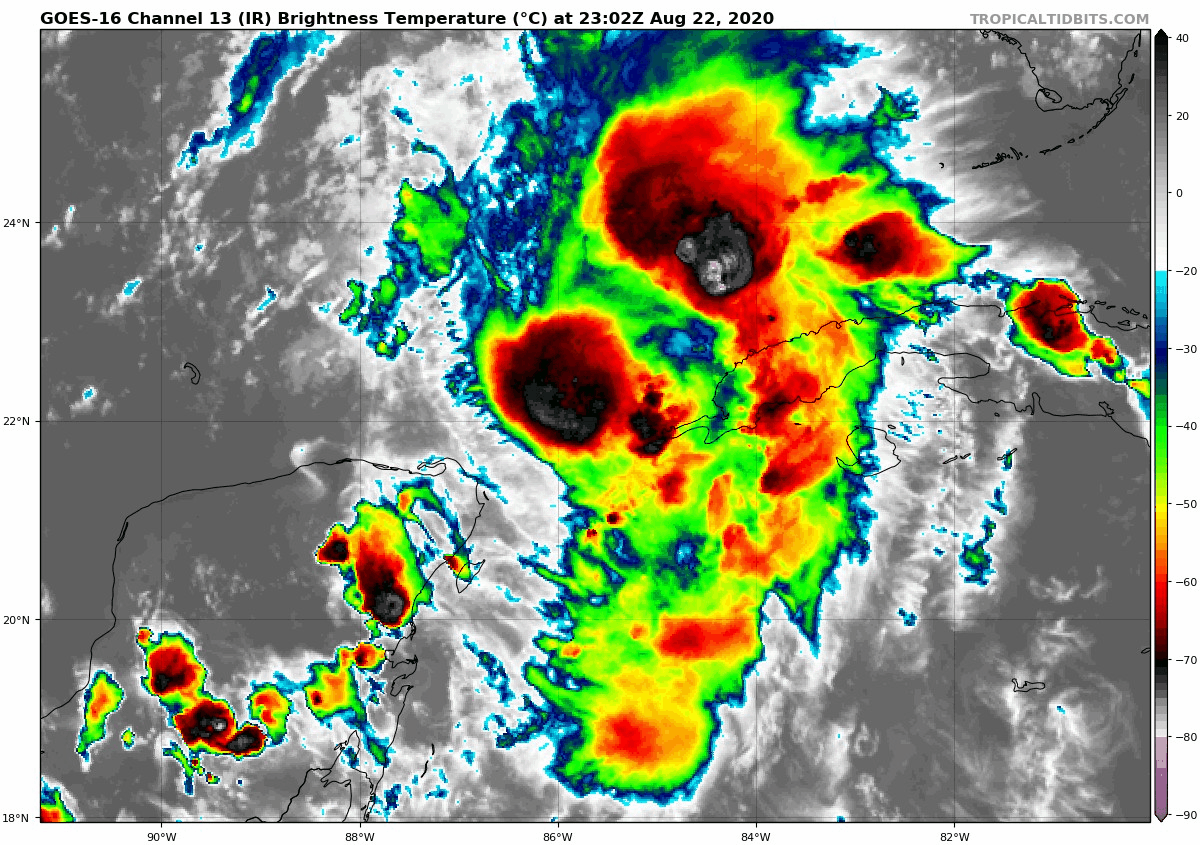
Gotcha, thanks for that. With all of the focus on the shear it's easy to lose focus on some of the other factors.
-
I'd like to see them do a drop from 10k on the NW side of the storm before they leave, get a bit of a snapshot of mid to upper level shear velocities/direction.
-
Dew's rising significantly at flt level in that drop. SHIPS thinks a decent chance at another 25KT over the next 24-36 hours.....
SHIPS Prob RI for 20kt/ 12hr RI threshold= 36% is 7.3 times climatological mean ( 5.0%) SHIPS Prob RI for 25kt/ 24hr RI threshold= 66% is 6.0 times climatological mean (10.9%) SHIPS Prob RI for 30kt/ 24hr RI threshold= 44% is 6.4 times climatological mean ( 6.9%) SHIPS Prob RI for 35kt/ 24hr RI threshold= 33% is 8.4 times climatological mean ( 3.9%) SHIPS Prob RI for 40kt/ 24hr RI threshold= 20% is 8.1 times climatological mean ( 2.5%) SHIPS Prob RI for 45kt/ 36hr RI threshold= 45% is 9.7 times climatological mean ( 4.6%) SHIPS Prob RI for 55kt/ 48hr RI threshold= 35% is 7.6 times climatological mean ( 4.6%) SHIPS Prob RI for 65kt/ 72hr RI threshold= 20% is 3.8 times climatological mean ( 5.2%)-
1
-
-
6 minutes ago, WxWatcher007 said:
This is a fun track. Watching the environment and in-situ obs with little to no backup.

Too bad both are going to make landfall and people need actual confidence in the forecast.
Like forecasting in the 60's when real men drew the charts lol. I'm already half way through my case of popcorn. Lights are flashing, take your seats for Act II
-
Never underestimate the energy available in 89F degree water
-
1
-
-
32 minutes ago, Amped said:
Never seen a TC with a 500mb vorticity field like this.

It is a model in the future and yes it's a bit strange. The Euro shows something similar but not as vigorous. My take would be it's a signal of rising air riding the western side of maybe a mid level ridge. Pretty stale winds off to the east so could induce some vorticity along that line. 200mb winds are from the SW almost on top of that and maybe stretching the latent vorticity NE? Might be a feature in the models that prevents some big dog strengthening. I'm sitting in a recliner with my dog watching Shipping Wars, what the hell do I know lol.
-
I think it's in the final stages of mixing out dry air that's been prevalent to it's N and NW the last couple of days.. I would venture to guess that we see some fairly significant sustained convection during DMAX overnight. If it misses the peninsula altogether there's not a lot in it's way until it hits potential forecasted shear in a few days. Not saying RI or anything but I do think it will be Marco by 5am at the latest. It sure is in a historical area to blow up
-
Yes it is going to be interesting to say the least. Been waiting all week to see where the initial placement of the pieces will be. I've been watching everything but the 2 potential storms looking for some consistency in model trends for placement of the bumpers in the giant pinball game and I don't see 1 or 2 dominant features that could make the forecast of these 2 potential storms any easier. There are several features from the west coast all the way into the mid Atlantic and as far north as Canada that are currently evolving. Subtle changes in any of these from current modeling will be problematic in any track/intensity forecast. I wouldn't be surprised to see extra ROAB launches from TX to the Carolinas at some point. I would say the level of uncertainty as it stands now is at a higher than usual level. The next 120 hours are definitely going to keep the NHC on their toes. Popcorn is out, let the show begin
-
1
-
-
15 minutes ago, WxWatcher007 said:
Progress today. Not a lot of posts on this system, but it’s a sleeper if it can organize nicely pre-Yucatán.
A tropical wave and accompanying broad area of low pressure is
producing a concentrated area of showers and thunderstorms over the
central Caribbean Sea. This system is gradually becoming better
organized, and a tropical depression is likely to form in a couple
of days when the system reaches the northwestern Caribbean Sea.
This low pressure area is moving westward, and interests in Honduras
and the Yucatan Peninsula should closely monitor its progress.
Regardless of development, this disturbance will likely produce
heavy rains across a large portion of Central America and
southeastern Mexico late this week and this weekend.
* Formation chance through 48 hours...high...70 percent.
* Formation chance through 5 days...high...80 percent.
Yup. Been waiting to see what happens as it distances itself from S. America (or vise versa as the coastline begins to recede lol)' If it can get it's act together and minimal if no interaction with the peninsula it's got plenty of fuel ahead of it and there will be no doubt of a landfall. The SE Gulf/NW Caribbean has a bit of a history of storms ramping up quickly. This one I'm a little more concerned with some collapse of steering IF it develops and gets into the SE GOM.
-
The proverbial figure skater pulling her arms in lol
-
2
-
-
If anything develops I think a lot is going to depend on the evolution of that monster SW conus ridge. GEFS and EPS along with the OP's show it breaking down to varying degrees around day 7 in general. There are trends toward zonal flow across the northern conus after that for a few days farther out into fantasy land across the board. A setup like that, IF it were to happen can sometimes lead to headaches forecasting a track for anything in the SE Bahamas, S GOM or the W Caribbean. Weaker steering and/or something getting trapped under a conus ridge-WAR battle. Stalls, left turns and loops oh my.
-
1
-
-
Nice depiction of inner core formation on MIMIC. This should be a fun one to watch over the next day.
-
1
-
-
3 hours ago, Windspeed said:
You mean the season so far or just the hype? The season so far is not really indicative of the potential that exists in a few weeks. If we're hearing crickets by the second week of September, then I'd start considering a bust. Still, we have had two hurricanes already, albeit not a lot of ACE withstanding. Yet, more than double climatological mean for this date. At any rate, a busy four-to-five week stretch can produce a lot of hurricanes. Too many examples of that to even mention. You can look up most active years and see when they really took off.
I would also add that as far as seasonal forecasts, a very real bust is certainly possible, though I think it is rather unlikely that we miss out on an active season. A bust for hyperactive forecasts is obviously still very much in play simply due to their rarity. That we had so many forecasts favoring hyperactivity is due to many favorable factors coming into play for the height of the season, which, we are not there yet. We're still waiting for all of those ingredients to produce. Also, bust or no bust, yes, we could have a nightmare hurricane landfall and if we do not reach sufficient ACE and numbers, it would still be a bust. I know most of you, if not all, realize this. But therein lies the rub, even if we do have a bust, those factors likely do produce some majors that track into the Caribbean. We don't have the same setup as 2010 and 2011. We're going to see some strong long-tracking hurricane impacts in 2020.
Edit: Err.. 2011, not 2013. lol... That an entirely different scenario. Just, no.
Also, I keep adding on and on to this post, sorry, however, I also want to point out that[mention=1541]Scorpion[/mention] never said anything about a bust. They were referring to hyperactive seasons with no major hurricane impacts. I just brought up the bust discussion because it seems to be floating around already in this thread and I was already rambling besides.
This. My biggest concern is exactly that. There's been consistent modeling of relaxed shear in the Caribbean for some time now, especially the eastern Caribbean. While normally the eastern Caribbean shear tends to relax during the peak it doesn't usually do it for very long, there always seems to be a retrograding TUTT that throws a fly in the ointment for any long track storm that gets in there and tries to traverse south of Cuba. Most years that shear tends to keep anything traversing the eastern Caribbean at least in check if not ripping it apart. Of course some have made it through if the timing's right but the eastern Caribbean is usually a tough place for any storm. The consistent modeling of a relaxing of that shear for an extended period of time increases the chances for a southern long tracker to sustain intensity right into the GOM. May not happen at all but I think there's increasing chances of that possibility.
-
On 8/3/2020 at 6:55 PM, A-L-E-K said:
love money
It's not real

-
31 minutes ago, WinterWolf said:
Well, if it’s going to be as active and anomalous as it’s predicted to be...then the shear and the dry air better be going away pretty soon!?
An average season of 10-12 has 2-3 named storms by now with 75% occurring over the next 6-8 weeks. This anomalous beginning is accounting for almost half of the very active season being forecasted. Since we already have 9, even and average Aug - Oct would put us upwards of 20. So it doesn't necessarily mean the tropics have to "blow up" soon in order to meet the current forecast. A moderate above average Aug - Oct, say 10-12, as opposed to the Aug - Oct 8-10 average could hit the threshold of some of the forecasts. I think that's an important perspective. We've almost got a 3rd of a high end 25 storm forecast in the bank by the first week of August. Even an average or slightly below average Aug- Oct portion will still put the entire season as well above average.
So the question is, has the anomalous above average season being forecasted already occured?
Edit: Just trying to point out that moving forward could be an average season in the timeframe left. Some people may be disappointed if storm after storm doesn't start cranking soon and think the forecasts are off. I'm putting odds on a normal, maybe slightly above normal Aug - Oct storm count.
-
1
-
 1
1
-

The "Double Trouble" Banter Thread
in Tropical Headquarters
Posted
I can guarantee, there's one guy whose got the bow of his airboat chained to a big 'ol Cypress with the ass facing south cranked at full throttle with Cranky next to him wearing goggles and a bicycle helmet yelling "keep it up, we;re shearing the hell out of it!" Now that would be a Cohen Brothers ending lol.