

Jackstraw
-
Posts
2,383 -
Joined
-
Last visited
Content Type
Profiles
Blogs
Forums
American Weather
Media Demo
Store
Gallery
Posts posted by Jackstraw
-
-
Just now, KokomoWX said:
Very light icing in Kokomo. I am seeing power flickers. Sigh.
Weird, I'm melting off the roof here. Windshield is water drops. Had some ice on the porch a few hours ago but it's melted. I'm up to 32.5 now. Gone up a degree an hour since 4am.
-
As I typed that the surface freeze line moved N of Indy. I'll be above 0C by 9am. Looks like if anyone is going to get ice it'll be NW IL/ SE IA. Most of MO at or above 0C now except for far NW. I really am surprised a 1006 low is lifting this much warmth this aggressively. I was thinking noon to 2pm to hit 0C from an overnight low of -5C. Not complaining, only thing I hate more than ice is mud. My temps up to 31F now. Guess I'll get the greater of 2 evils lol.
-
 1
1
-
-
24 minutes ago, IWXwx said:
For my Indiana guys, mike Ryan just posted this in NWSChat:
Happy New Year everyone! Freezing rain is the story this morning, and the band east-west through the Indy metro is producing the steadiest rates so far this morning. As this band moves north over the next 30 minutes, precipitation coverage looks to be a bit more scattered. Also of note, the 32 degreee line appears to be following a county or so south of the location of the band. Bloomington has gone above freezing in the last hour and Terre Haute appear poised to do likewise within the next hour. Still think the Indy metro pulls above freezing from south to north in the 830-10 am timeframe. Road temps are in the 30-32 range over north central Indiana, 31-33 in the Indy metro and above freezing south of I-70. Finally, a trend we've noticed all night back into Missouri is that ice accrual seems to be roughly half to two thirds of the precipitation totals. That has held here...BMG had 0.11 inches precip and 0.06 ice accrual. in the last hour.
Was watching this earlier. Surface freezing is just south of I70 right now. According to meso analysis 925 freeze line is up to Ft. Wayne and 850's are already half way through MI. Had some light ZR a little while ago, maybe some ZR drizzle now with a surface temp of 30 and climbing already. WAA is going to blow through most of IN if this keeps up. Don't think we have much to worry about except lots of cold ass rain. I would venture to say even points to the far NW may come out better. Looks like as always the WAA overperforms the models. Kinda surprised. I would think as this thing shears out the pump would weaken. Mediocre Pacific heat pumped by that extra tropical storm NE of HI last week along with untouched GOM torch water and damn near 0 arctic air mass leads to the GFS solution Saturday for us. A freakin mess lol.
-
 1
1
-
-
How the hell can a warm blooded hairy ass animal go outside for 30 min and come back in looking like a frozen freak show? I have a new ZR gauge.
-
2
-
-
Just let the dogs in. No precip 30 min ago when I let them out. They look like Billy Idol twins now, freakin frozen Godzilla spikes on their backs lol.
-
 7
7
-
-
This is a bit surprising, or not lol. Freezing level is really really shallow already, maybe 2k feet. Depth of the warmth is under 700 mb right now. Models had it deeper yesterday.....

-
06Z HRRR sounding in my area around 10am Fri. Some deep saturation and pretty strong forcing. That's a deep ass warm tongue if I've ever seen one. Similar soundings a couple hours either side. Will be interesting if it pans out....

-
1
-
-
Ripped a Gomer surprise 1.5" earlier. Slick as a Witches T$%t out.
-
3
-
1
-
-
42 minutes ago, Hoosier said:
Multiple sites in northern IL are reporting freezing rain with temps above freezing.
I have noticed that before. Not sure why it happens. I wonder if it's more common when dews are a few degrees below freezing, which is the case right now.
That would make sense. Not sure how cold for how long they were up there but hard surface temps would lag behind air temp increases also, especially if air temps were jumping up quickly. We had some decent ice here about 3 years ago with the air temp around 27 over the dark hours rising to 35 by early morning when the precip hit. Had a nice glaze over everything by noon with a temp, and the sun, of around 35-36 before it crashed. It was weird because the glaze all thawed at once on a sunny afternoon and just started falling off the trees all at once.
-
Be interesting to see where the confluence zone sets up between the 2 waves. Couple models were pinstriping some decent snow just north of it yesterday morning. My temps have been actually dropping as opposed to rising as forecasted. Been at 32 most of the day now down to 29 and 0 precip thus far. Precip shield is well N/NW still. Hey man, I can dream

-
21 minutes ago, hlcater said:
Final total of 9.2" taken from average of snow boards around the yard. Well forecast and very respectable event. Quite a bit of FZDZ out there currently and it's quite nasty. Should end up with solid glaze by morning. Temp 30.
Honestly the first event I can remember where I'm left thinking ... Damn did the canadian do a good job.
I was surprised how well it did (at least against itself) with the tropics this year. It was pretty tight on the H5 anomalies over the summer which could've made it look good tropic wise especially with GOM tracks. To be honest, this past summer the H5 setup resembled what's going on now.
-
1
-
-
Cudos to those that got the hammer. Those that got the sink, models seem to be giving you a second chance SE bump with wave 2. Looks like there will even be a moisture starved wave 3 that could toss those of us in the orphanage an inch here and there maybe Sunday. NYD is forecast to be the warmest at KIND since 2000, ROCK! There's plenty of consistency over the next 10 days from the models... for absolutely nothing. WTF do they know! lol

-
1
-
-
18 minutes ago, hawkeye_wx said:
My snow total is 8.5". The 12" report just south of me sure seems like a lot.
This was the most satisfying snowstorm in years.
Nice and most deserving of late. Looks like you're gonna get to keep it for at least a week too.

-
2
-
-
As the mania of the front end thump wanes to the reality of the 850 devil, it can be very depressing so feel free to message me, it's the story of my winters lately here in the hinterlands and I have a way to deal with it

-
1
-
-
45 minutes ago, cyclone77 said:
Feels like I'm in LAF on 2/1/11. Raging sleet shower right now hammering the east windows.
-
2
-
2
-
-
Just now, StormChaser4Life said:
Yea models did depict dry slot well. It just seems like this moved out so fast. Maybe I'm wrong. Cutious to see what model did best so we know which one to watch closer for 2nd storm.
The models recently are like watching NeckCar at Talladega. Whomever is leading, the next lap they're liable to be 20th the following lap. But there's gonna be 2 or 3 big ones they catch, just a matter of where east of the Mississippi it happens

-
2
-
-
8 minutes ago, cyclone77 said:
Mostly freezing rain with a few pingers now here. Went out and removed the snow before it became encased in a crusty layer. Picked up 4.5" snow.
Good job, now put it back when it's over and you can act like the nasties never happened!
-
1
-
-
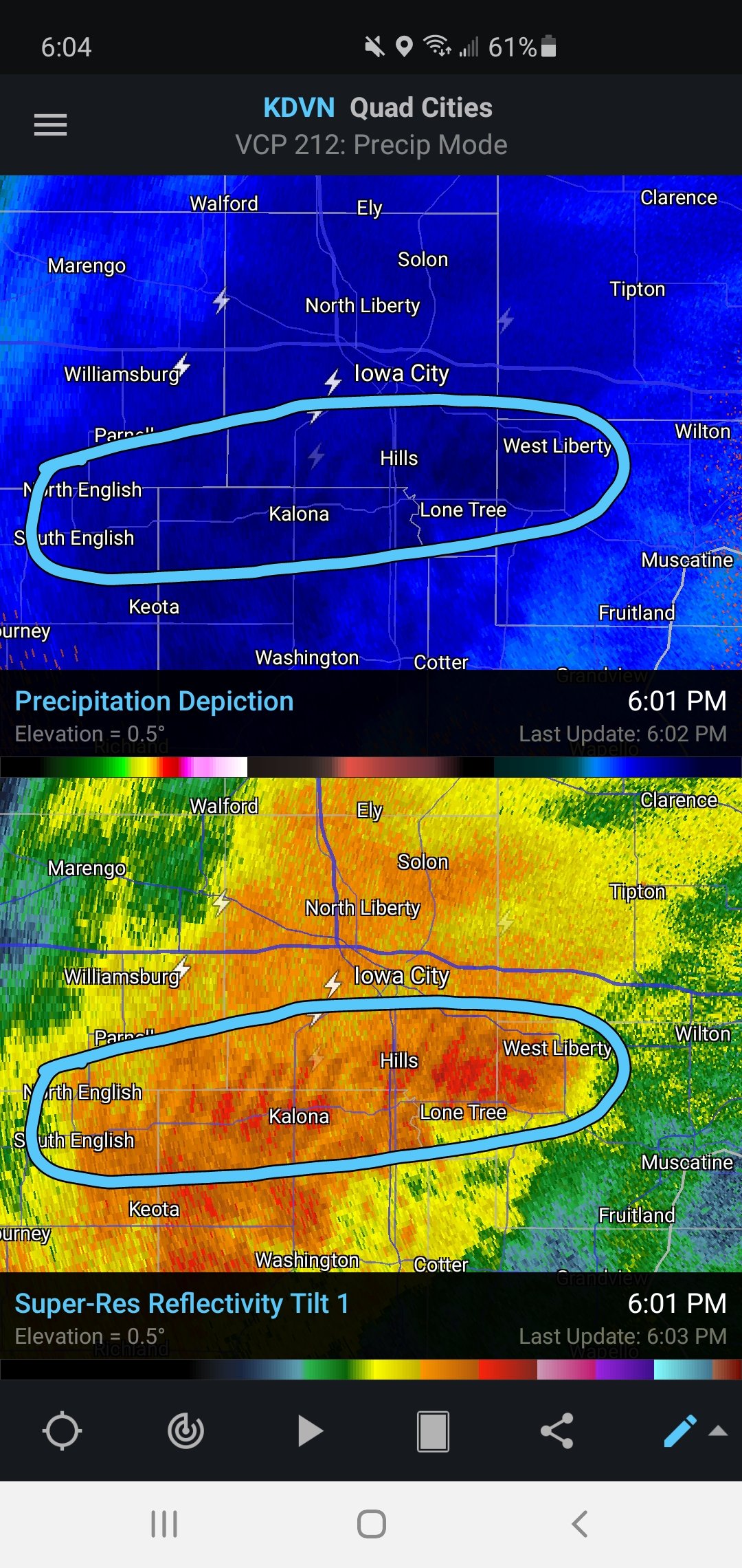
7 minutes ago, StormChaser4Life said:
The convective nature of the snow in Iowa was very impressive. Tons of lightning strikes showing up near and north of the transition line. You can see gravity waves on reflectivity. Pretty awesome.
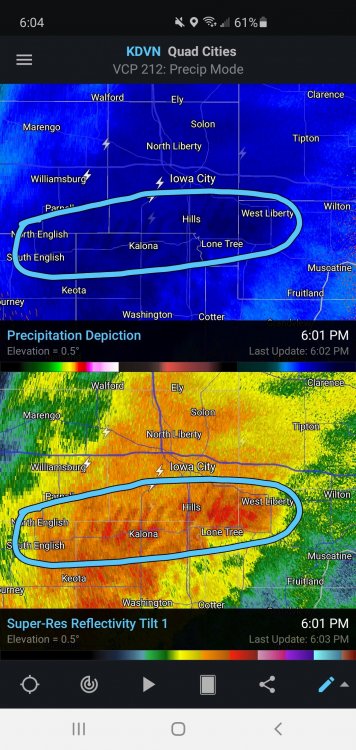
Saw that on Scope also (seeing as how it's the only decent radar left!). Meso was showing some decent 6-6.5 lapse rates moving up ahead of the mixing line. Don't think I've ever seen gravity wave depictions on radar in a winter storm.
-
1
-
-
I'm down near the end of that proboscis band and my sounding is almost as good... except it'll last 5 minutes lol....

-
1
-
-
Pretty rippin' sounding in Chicago Tues. evening...

-
4
-
-
The 00Z GFS is just a big fat icey, sleety, rainy kiss my ass kitchen sink mess. Just what I'm used to the past few years

-
1
-
3
-
-
Nice LR discussion from Ryan at KIND.....
.LONG TERM /Wednesday Night through Sunday/...
Issued at 241 PM EST Sun Dec 27 2020

The second part of the storm system set to impact the region the
second half of the week remains the primary focus for the extended
and unfortunately at this stage of the game...is offering more
questions than answers on specific impacts for central Indiana on
New Years Eve and New Years Day.

A strong ridge across the eastern half of the country will be slowly
but steadily flattened by a strong upper low that will pinwheel out
of northern Mexico and across Texas Wednesday night and Thursday
before lifting north into the Great Lakes by late Friday. There has
been a noted westward shift in the model suite over the last 24 to
36 hours with respect to the upper low track due to more energy
aloft carving out the massive trough over the central portion of the
country and a strengthening of the upper ridge off the Florida
coast. The upper low takes on a negative tilt which pulls it further
west as well.

That being said...the model suite is all over the place with its
handling of the secondary surface wave set to develop along the
frontal boundary and lift northeast towards the Ohio Valley by late
Thursday. While there has been a westward shift at the surface as
well...the main operational models with the exception of the GGEM
are further west than the ensemble means. It should be noted that a
surface wave track due north or slightly east of north off the
Louisiana coast is a bit of a climatologically unfavorable track for
a surface wave. Just another point to toss into the jumble of
thoughts this afternoon. A general blend at this point is preferred
until better model agreement can develop.

So...what can we take away at this point 4-5 days out? Confidence is
high in a higher impact storm moving through the Ohio Valley and
central Indiana for New Years Eve and New Years Day. But that is
about all that can be said right now. The lack of model agreement
and fluidity of the entire suite lends no confidence into the
details of the forecast and impacts...namely precip type duration
and intensity. The storm will have access to a rich plume of
moisture from the Gulf of Mexico which will ensure modest precip
amounts from Wednesday night into Friday. Expect rain to continue as
the precip type to start Wednesday night with the potential for some
wintry mischief on the northern flank of the precip shield late
Wednesday night into Thursday morning as low level thermals become
marginal. There is likely to be a lull in precip coverage on
Thursday before moisture returns with the approach of the second
surface low late Thursday into Friday. Storm track will become
critical at this point in determining precip type but the potential
for at least some snow and/or ice accums is a possibility that needs
to be considered. A track that ends up east would bring a greater
risk for either snow or ice but even should the track of the low
remain further west...an easterly flow in the low levels Thursday
night into Friday morning as the low approaches could present some
problems over the forecast area with an increased potential for an
icy mess in the form of freezing rain and/or sleet.

Expect at least another 36-48 hours before we can gain more clarity
on the details with this storm system and the likely impacts locally
here in central Indiana. The primary area of upper energy will come
onshore over California on Monday with better sampling of the
feature coming thereafter. At this point...prepare for a higher
impact winter storm over the Ohio Valley from the second half of
Wednesday into New Years Day with locally heavy rainfall...a wintry
mix or perhaps some accumulations of snow and/or ice all within the
range of possibilities. Dry and chilly weather will follow the
departure of this system for next weekend.
-
Final call, frozen mud stalagmites and some dandruff falling
. I wasn't touching this one with a 10 ft North Pole lol.
-
1
-
1
-
-
Woke up to a nice fluffy 4. Finally looks like winter out
-
6
-
Dec 29-Jan 2 potential storm event
in Lakes/Ohio Valley
Posted
HRRR been trimming the southern extent of ice in Indiana but cranking it in northern IN and far southern MI and NW OH over the last 6 hours....
.