

snywx
-
Posts
10,484 -
Joined
-
Last visited
Content Type
Profiles
Blogs
Forums
American Weather
Media Demo
Store
Gallery
Everything posted by snywx
-
Already down to 3 here.. prob will be below 0 by midnight.. deep deep winter up here
-
 7.2” here 22.6” for the season so far
 -
Looks like 7.2" is gonna be my final here. Most of that fell in a 2-3 hr period
-
Looks like a general 6-8" fell in the HV from Orange to Dutchess
-
22° w/ Lgt snow 7.2" on the board.
-
Agreed.. that’s why I specifically mentioned for amounts only in this area
-
They failed miserably for the interior. GFS wasn’t too bad but overall in terms of amounts for our area, Canadians won
-
25° w/ Moderate snow 6.2" on the board
-
5.8" here It has lightened up considerably. An additional 1-2" would be nice
-
26° w/ Lgt snow falling I think we have one more round of heavy snow to deal with up here before it shuts off. 5.8" on the board
-
We were always forecasted to get 6-8". The forecast never really changed for those NW of NYC.
-
28° w/ Heavy snow Close to 2" an hr rates now 4.0" on the board
-
28° w/ heavy snow Easily 1-1.5" rates right now 2.5" on the board
-
28° w/ Lgt snow Lull for the past 20 mins but starting to pick back up 1.5" otg
-
28 w/ moderate snow 1” otg
-
29 w/ steady lgt snow coating on all surfaces
-
30° w/ very lgt snow falling - 3 mi W of Middletown NY
-
Temp is 30 w/ overcast skies expecting 4-6” up this way. Less than what was Initally expected due to lower precip amounts.
-
Yeah having to rely on ratios isn’t gonna cut it up here. 3-5” looks to be the consensus up here now. LI up into ENE look to potentially cash in on those 6”+ amounts. If it snows in central/eastern Suffolk can almost guarantee we will be on the outside looking in. Seen this movie a few times before
-
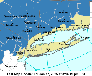
Good map.. not much has really changed other than areas a bit further east getting in on advisory level snows.
-
This is true.. still expecting 6-10” here. 3-6” I think is a good call for the city-eastward with highest amounts on the coast being concentrated in and around the 5 Boros
-
18Z RGEM is an absolute crush job up here. 10"+
-
Did you expect anything else?
-
As expected.. General 6-8" NW of the TZB
-
Classic interior event on the CMC/RGEM


