weatherwiz
-
Posts
79,817 -
Joined
-
Last visited
Content Type
Profiles
Blogs
Forums
American Weather
Media Demo
Store
Gallery
Everything posted by weatherwiz
-
Hopefully we get a solid MCS...been quite some time since we had a solid legit MCS roll through
-
Don't models tend to poorly handle MCS propagation, especially in these regimes? Models in general though seem to struggle with how convection behaves when you have sharp instability gradients. In real time the convection will follow the instability axis but models tend to place a greater emphasis on other variables. Anyways look at the GFS and where it tracks the MCS then look at MUCAPE...if we were to fast forward to verification time my bet would be the MCS making a sharp turn across southwestern NY into PA.
-
My initial wondering/thinking is whether the models are too far northeast with the MCS. Verbatim I am wondering if this would track to our southwest as that is where the instability gradient is most defined.
-
Likely some certainly helping but I think they've also been along an instability gradient and there have been subtle vorts moving through
-
I wouldn't focus on model 2m output this far out...outside of looking at it for fun. As always, there are going to be several factors which are going to determine exactly how high temperatures get and these are more for the mesoscale time frame. If anything is going to hinder us it will end up being high clouds passing through. This would be something MOS won't pick up so as we get closer if MOS has 101 or 102's...better be checking potential for high clouds and what MOS has for dews and whether it looks overmixed
-
Where is ineedsnow
-
there will be two corridors for tomorrow. Climatologically PHL-NYC does extremely well in these setups.
-
Nadocast can be weenish but that's some impressive probs for this part of the country
-
you probably need to delete attachments...probably don't have enough space
-
well that was not phrased properly
-
I foresee me working Ray's weenie OT over the next two days Finally some exciting severe to post about
-
Yeah not sure what is playing into the HRRR but we have decent height falls tomorrow, increasing dynamics, steep lapse rates, and moderate instability. I know the main forcing/cold front is west...but more times than not our convection develops with the pre-frontal trough and not the actual cold front. But I would not be shocked to see the HRRR ramp up as we get closer. Same thing with the mid-western states...HRRR I think underplaying, especially Mississippi Valley
-
Storm mode will evolve to be linear quickly and flow aloft is predominately unidirectional, however, enough turning of the llvl winds that there is certainly a risk for an embedded tornado or two, particularly within the Hudson and Connecticut Valley where the backed flow will be enhanced some. Also looks like a bit of a theta-e ridge which will locally enhanced llvl CAPE and decent sfc vorticity. The line arrives coinciding with an increase of the LLJ as well and models want to hang around the steeper lapse rates. If we can get discrete cells ahead of the line (big if) there will be risk for multiple tornadoes.
-
I think the HRRR is underplaying aerial coverage tomorrow
-
We shall be seeing an enhanced risk tomorrow for at least western MA and western CT
-
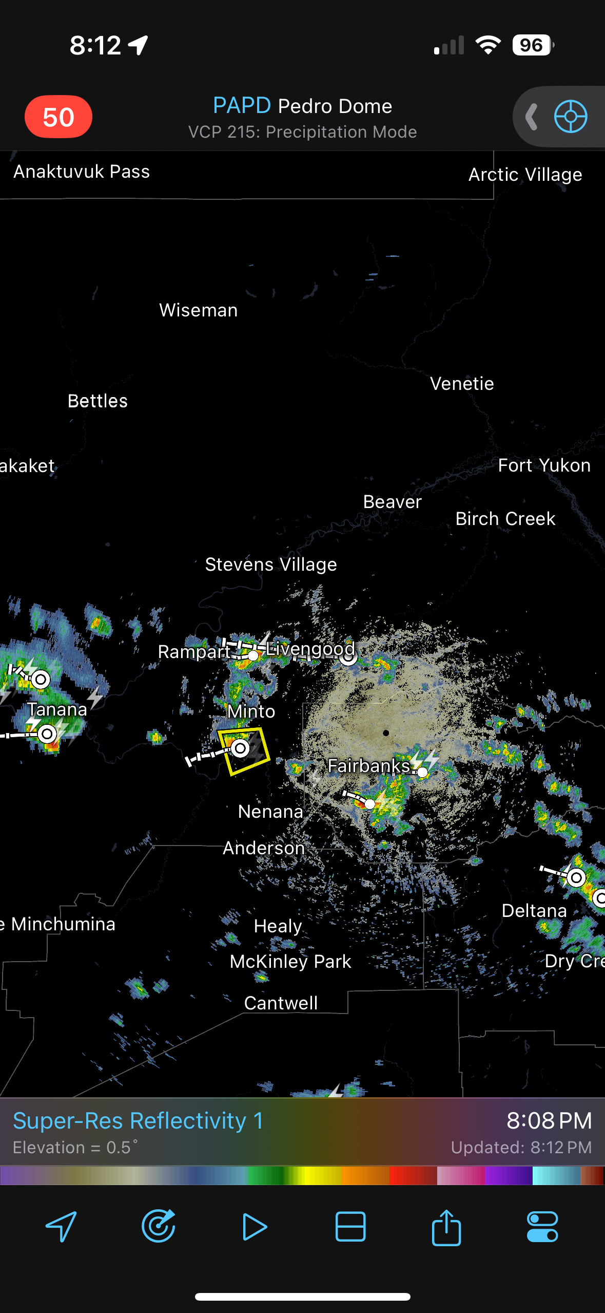
It lightens up for a bit and then back to a moderate rain.
-
This rain is RELENTLESS. Been a moderate rain much of the day with some periods of light rain.
-
yup...miserable today. Not sure what time the rain started here but took the dog out around 6:30 AM and it was raining pretty good.
-
Later today I am going to make a special thread for what is upcoming...focusing on convection but there will be other goodies
-
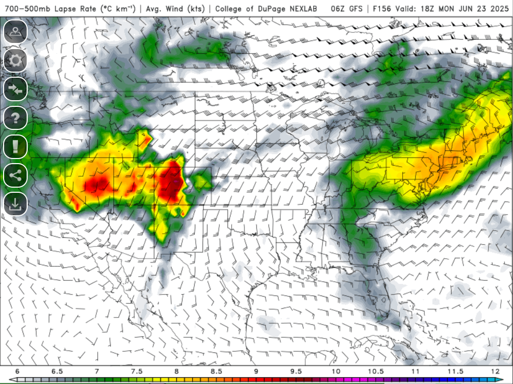
At least on the NAM anyways...pretty big differences between GFS/NAM with the thermodynamic environment due to whether we can get that EML plume to move through. It's possible the environment across the Great Lakes/Ohio Valley region becomes convectively overturned but NAM has ~1500 J MUCAPE traversing the region overnight...not bad
-
Could see a few thunderstorms tomorrow night make there way in from PA/southern NY. Pretty good elevated CAPE around if storms can hold
-
Too bad no vort coming through

-
Those that didn't install are going to be in deep, deep trouble. Time is running out folks. Once this heat/humidity comes it isn't going away for quite some time. You've been warned
-
This is what we live for