

weatherwiz
-
Posts
76,560 -
Joined
-
Last visited
Content Type
Profiles
Blogs
Forums
American Weather
Media Demo
Store
Gallery
Posts posted by weatherwiz
-
-
18 minutes ago, ORH_wxman said:
Seems like wiz lost the point. He started talking about March making up for the entire season of snowfall deficit when the discussion was really about any decent storm at all.
Yeah, it’s pretty unlikely we get enough snow in late February and March to get back to average snowfall in most areas of SNE.
But it’s not unlikely that we get another good event...say, high end advisory or better.
I think March has potential to be quite warm...if the AO remains as strongly positive as it is...which seems plausible combined with the look of the Pacific...once we start
lengtheningshortening the wavelengths as we near spring we could roast. I think we'll have to get lucky and time something right with a shot of cold air...that's not going to happen with this end of the week shot so we'll have to wait for the next one...which may not be until sometime next week...which may not even come out to be much if the AO rises like it seems to do-
 1
1
-
-
Just now, powderfreak said:
I totally get the seasonal vibe everyone is quoting as a reason to give it up, but it surprises me every year how many of you have no faith in March as a winter month.
March at BDL averages pretty much the same snowfall that December does...6-7”.
It isn’t outlandish to think it *might* snow.
But it's more than just the seasonal vibe...it's what's occurred through the season. It would be totally different if the atmospheric state was different and we were just missing events...but that hasn't been the case. The entire hemispheric pattern has been pretty horrific...especially regarding the Arctic and that circulation has not only been strong but it's been dominating. This just isn't going to change overnight or in a week or two. There needs to be significant impact and disruption for changes to occur and there is typically a good 2-4 week lag from when those disruptions occur to the evolution of the pattern.
All winter long...all winter long has been nothing but "500 looks good in 10 days" "EPS looking good in the long range" "GEFS and EPS agree it's coming" blah blah blah blah
There is a reason why everything is shown at D10 and then the signal just completely disappears inside D5-6...models are always, always way too fast to completely change a pattern and there was never anything which supported the Arctic circulation changing...outside of what ensembles or D10 progs have shown...where there are disruptions occurring at the present that's when you can expect these D7-10 solutions to hold merit.
I understand the theme is winter, cold, and snow and people don't want to hear things which dispute that...but when facing hard core reality the drawing has been on the board since the end of December/early January how this winter was going to unfold.
People can do all they want to try and hold out hope that March will deliver...and then try and toss some past years which delivered to make them feel better or as a method to install hope. Even all winter (like what typically happens) those who have been "poo-pooing" winter and any threats get **** on but at the end of the day they've been spot on.
People who like cold and snow just don't want to hear anything that disputes those possibilities.
-
1
-
-
When you have to hope for March to deliver to make things up....:

Has it happened before...sure, but the odds aren't great.
It's like being 20-games out of a playoff spot with 21-games left...it's over...it sucks but move on. "Hoping" isn't going to make things change
-
2 minutes ago, Damage In Tolland said:
Sounds similar to snowy late Feb and Morch calls
I can already smell the tulips
-
 1
1
-
 1
1
-
-
We could really be heading towards a snooze fest of a pattern...to me it seems like a pattern we would see between the transition from fall to winter...where things sort of quiet down after the fall and then we establish our winter pattern. But there seems to be strong support for large high pressure to become established over a major chunk of the U.S. Patterns like that can hold for quite a while too. I'm guessing after that pattern we could bold right into a late spring type pattern.
-
1 minute ago, RUNNAWAYICEBERG said:
You do it all the time already. We get it. You hate social media and snow maps while having a problematic compulsive behavior towards any hint of convection, globally.
Only part of this statement is fully accurate...though the jest of it is true.
-
3 minutes ago, CoastalWx said:

One of these days when I have time I'm going to go on a nice ranting blog post about this and snow maps. Perhaps I'll do that this upcoming Sunday.
-
3
-
-
11 minutes ago, mahk_webstah said:
I like Tips posts, especially in the context of today’s text and abbreviate culture. We have collective cultural ADHD. The thought of having to actually sit and think and read and think more to make sense of something seems to be a shrinking skill. Damn I sound old. But weather patterns are complicated and can’t always be reduced to a tweet. We Should be greatful for the skilled posters who are willing to take the time to really dissect something, and Tip is not the only one.
Couldn't agree anymore here...people are willing to wait hours in line for food or shopping, but when it comes to reading something forget it. Same goes to forecasting...constructing an excellent forecast requires a great deal of time and detail. Forecasters who spend the time to look over all variables and use knowledge to determine "what makes the most sense" are going to be more accurate than those who don't. Forecasting now is almost becoming a joke b/c it's just rip and read off a few products and go from there.
-
3
-
-
23 hours ago, Dr. Dews said:
Hopefully this severe season will be as amazing as this winter
We'll be tracking severe wx in June and people will still be holing out hope for a pattern change and snow
-
 1
1
-
-
3 minutes ago, Ginx snewx said:
Nah, climate talk severe talk it’s all relevant in a February thread


-
1
-
1
-
-
18 minutes ago, radarman said:
2008 also had the crazy long tornado in NH
2012 had the only tornado on BID and the landphoon
2014 had that notable tornado that hit the Boston area (Revere esp)
2015 was pretty meh I think, may have been a tornado near Hubby
and last year was all about Cape Cod
yeah the Swanzey one which happened like 10:00 AM in 2008
2012 I think even had a couple in CT from that same event
could even go back to 2007 (which had the supercells on June 5) and 2006 (derecho in August and a major event July 18
1 minute ago, Dr. Dews said:hurricane and tor talk, this is great. Let's not forget the march 13th? supercell back in 2010, was it?
that was April I think...went to the Baseball HOF that day...if we're thinking same event
-
1
-
-
4 minutes ago, radarman said:
If you mean baseball scoring and monster tornadoes, that was 2011. 2010 had the June 6th mod risk day, that mostly busted, though not entirely.
3 minutes ago, HoarfrostHubb said:
Dude, what about the Springfield/Monson tornados in 2011?!?! Those were about as severe as New England getsughhhh that's what I thought but I edited and revered them.
My memory isn't what it used to be.
I'm going to re-edit back so it's correct
-
 1
1
-
-
The past decade has been pretty solid for severe too.
2008 was wild with the cold pool hail events (that year alone accounted for like 15% of NYS hail reports...from 1950-2008).
2009 sucked
2010 had back-to-back tornado watch days
2011 had June 1st
2012 I don't remember
2013 I think was the year CT had the 4 weak tornadoes in July (though this could be argued it was the same tornado that kept jumping)
2014 don't remember
2015 don't remember
2016 we had that major outbreak in February
2017 I think this was a second half of summer driven with the nocturnal lightning producing events
2018 had May 15 then September/October was kinda wild. Tied record year for tornadoes in CT
2019 kinda sucked actually
2020...Going to Oklahoma!!!!!!
-
1
-
1
-
-
Just now, weathafella said:
That’s 1936-37. 9 inches for Boston’s all time low. FYI 2011-12 was 9.3 inches.
Just now, NorEastermass128 said:Yep. 1936-37 I believe. The rattiest of ratters that ratted.
Thank God social media didn't exist then
-
1
-
-
Is that not even 10'' just before 1940? ouch
-
1937-1938 looked like a poop winter


-
Just now, TauntonBlizzard2013 said:
We aren’t even getting clown snow anymore. 384 hour clown map through March 1 on the gfs offer 0 snow south of the NH MA border. That’s pretty incredible for this time of year. I mean we start getting faux clown snow in like September
About the time of year where we transition from 384-hr snow maps to 384-hour CAPE maps..well you have to hover over each hour b/c obviously there is no "total cape".
With that here's 318-hours


-
2
-
-
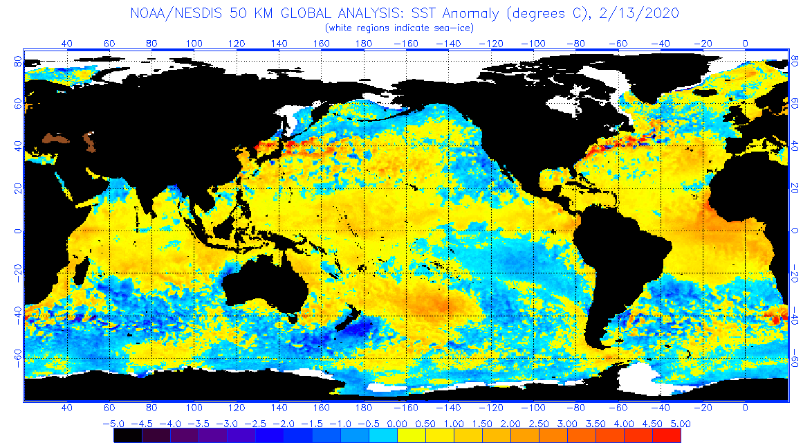
Waters off Africa are quite warm...just based off of looking seems like you have to go back to 2016 to find similar anomalies at the same time frame. I think that was an active Cape Verde season? If that persist into the summer with ENSO neutral or ENSO negative...maybe an active Atlantic season.
Anyways, sometimes I like staring at these maps (though haven't done so in a while) and think about how these anomalies help to shape and configure the pattern and what relation/role they have in some of the major oscillations/teleconnections.
-
1 minute ago, Ginx snewx said:
You know that Australian wildfires have occurred which burned more acres right? We get in the way by not allowing open burns trying to control the natural way. Same with building on barrier beaches. Sand moves. The problem is us and our decisions. Being smarter is tough when people make decisions based on money or fear.
Excellent post...true and very valid points.
I have read that regarding those wildfires...I guess what seemed to be the larger concern was how these intense fires started well before their "actual" wildfire season...?
-
16 minutes ago, Ginx snewx said:
Finding good news doesn't always have to be bad. I like to think nature finds a balance perhaps it will.
I strongly agree here...in fact, I think one could argue that the result of some of what is going on is tied into the balance trying to be re-stored. I know the Earth goes through cycles and the Earth has gone through periods of extreme warmth before...but when you account for the population now compared to back then the scale of the impacts are much more extreme.
Obviously it can be argued whether humans are directly related to the changes in climate or not...but whether humans are to blame doesn't really change the fact that changes in climate are resulting in significant disruptions to lives/nature. Australia is a great example...now perhaps centuries or thousands of years ago the Hadley cell went through a similar shift to what is occurring now and human-induced climate change isn't to blame...but that's minute. At the end of the day millions of people and wildlife are being impacted.
-
2 minutes ago, WinterWolf said:
Oh GOD....I'm so Concerned LMAO. Meanwhile the ICE in the Arctic as Steve pointed out has increased..but nobody wants to talk about that lol.
Yes it's increased but still well below what it should be.
Meanwhile, in Antarctica ice sheets bigger than big cities are breaking off.
anyways, I know this stuff belongs in climate change (and for obvious reasons) but this is always a subject that people will agree-to-disagree on but at the end of the day people's opinions on the subject mean absolute crap b/c what is occurring will continue to occur whether people want to believe it or not. People's opinions aren't going to change how climate will continue to evolve moving forward or that ramifications it will have.
-
2
-
1
-
-
1 minute ago, HoarfrostHubb said:
Poke this
If that is true to size then I pass
-
3
-
1
-
-
2 minutes ago, Damage In Tolland said:
Yup. Everything is pointing to that. Even have ridging poking up into E Canada. Nothing to stop the warmth
Let start cranking those SST's and limit marine taint once severe season ramps up here
-
1
-
-
It's crazy the models are already poking into March. This means in two months they will be poking into May!
-
1
-
4
-
February to Forget Volume 2 - 2020
in New England
Posted
I meant to say shorten...not lengthen.
If we were in a completely different state I wouldn't be so quick to write off March but I just don't see the changes needed to completely disrupt things. Some winter the PAC completely dominates and when it's an unfavorable PAC we can be screwed big time...this time it's the Arctic. The signal is just too overpowering.