

weatherwiz
-
Posts
71,228 -
Joined
-
Last visited
Content Type
Profiles
Blogs
Forums
American Weather
Media Demo
Store
Gallery
Posts posted by weatherwiz
-
-
18z sounding. This is pretty ridiculous.

-
 1
1
-
-
It's shaping up to be a pretty big day tomorrow too from LA to the FL Panhandle.
-
Some interesting CC returns over Muskogee right around where the rotation is. Like right over the city
-
That's a nice looking couplet/inflow notch
-
RAP is projecting around 200 J of 3km CAPE around the DFW area later on with as much as 2000 J of MLCAPE. Anything discrete is quickly going to become tornadic
-
1
-
-
41 minutes ago, Bob's Burgers said:

that supports an upgrade to high
-
2 minutes ago, METALSTORM said:
Even if they don't go with a high risk their will probably be a PDS tornado watch for that area in the late evening
agreed.
-
1 minute ago, Bob's Burgers said:
You could probably extend that further into AR if you believe that latest HRRR trends. The Super Tuesday analogue seems less comical now than it did a few days ago
Yeah definitely couldn't rule out a farther expansion of that area...especially if you want to consider the damaging wind aspect...I sorta focused more on tornado probs but if I were to include winds it would have been much bigger
-
If we see an upgrade to high risk b/c of tornado probs this is the area I'm thinking. Latest guidance really hammering in on this area

-
1
-
-
4 minutes ago, CheeselandSkies said:
Yeah, that is a lot less 850-500mb veer-back than was shown in most NAM forecast soundings 24-36 hours ago. Much more favorable wind profile in the low to mid levels.
Much cleaner look for sure.
-
I wouldn't sleep on southern MO either...wouldn't be shocked to see probs expanded farther north...maybe ENH into southern MO

-
12z sounding out of DFW...yikes

-
3
-
-
3 minutes ago, cstrunk said:
It seems like the biggest discrete supercell tornado threat this afternoon will be initially near I-35 from central TX northward into Oklahoma. We may get a cell or two a bit further east in TX but it's much more conditional.
More concerning is the latest HRRR which show a nasty QLCS moving through NE TX, while a string of cells forms ahead of the line near the TX-LA border. Those could be our dangerous nocturnal tornado producers, aside from the QLCS itself.
It wouldn't surprise me if a bunch of people start crying bust by 7-8 pm and the main show begins shortly thereafter.
Yeah this is something to definitely watch and I think hi-res models are starting to hint more and more at this possibility. Given the environment you would think outflow from the QLCS could be vigorous enough to produce updrafts out ahead of it.
I think there are two windows here for tornadic supercells...initially (or early on in the game) and then again moving into the overnight...especially with the nocturnal increase in the LLJ...this coincides with another burst of instability (due to increasing llvl theta-e).
Could be a long night from SE TX into LA and perhaps even as far north as AR (in terms of tornadoes).
-
1
-
-
Moderate risk to be expanded farther east with the new outlook.
Seems like there is pretty good agreement across guidance that the greatest overall tornado threat may be across southeast OK into northeast TX...though I still would watch out across southeastern TX...I'm not totally sold either that there isn't more discrete than what is currently shown...there are some hints at it but nothing glaring.
The damaging wind threat though is looking pretty legit.

-
3 minutes ago, Drz1111 said:
This strikes me as a warm-season plains chaser mindset, when this is a cool season Gulf Coast / Dixie Alley setup. "Widely visible tornadoes" isn't really relevant when storms are moving at warp speed and LCLs are scraping the ground.
Can also throw in the fact that the greatest tornado potential also extends into the overnight hours
-
This is in SE TX right around when the NAM peaks the STP. Most striking thing is seeing MLCAPE values just under 2000 J/KG. Also it's pretty backed in the lowest km.

-
7 minutes ago, JasonOH said:
Mean wind isn’t on the hodograph (In that sounding) so storms should naturally turn right. The VBV doesn’t necessarily inhibit tornado genesis unless it’s below 750mb. I have noticed that on a lot of violent tornado days there is a bit (not a ton) of VBV at just above 700mb.
I'm sure too the overall environment would certainly play a factor too? For example, there is going to be extremely favorable ingredients in the lowest 3 and especially 1 km's...plenty of directional shear, pretty low LCL's, and more than sufficient instability...should see plenty of sfc vorticity juxtaposed with ample 3km CAPE
-
This continues to look scarier and scarier...especially when you consider the best ingredients lining up at night. NAM showing a rather large area too of 1500+ MLCAPE...quite alarming given the other parameters in place. Forcing and s/w support not lacking either
-
I think this is looking rather concerned across eastern TX into LA. That's a pretty significant EML advecting in from the Mexican Plateau characterized by mlvl lapse rates which may be in excess of 8.5-9 C/KM...typically I would be concerned about extremely strong capping, however, not with this forcing present. What this CAN, however, result in is a "less messy" warm sector with stronger heating than modeled...when you're talking about mlvl lapse rates that steep with sfc dews ~70...CAPE can become significant...1500-2000 J/KG of MLCAPE is very possible. bufkit soundings (IAH) also indicating > 500 J of 6km CAPE with > 45 m/s of shear...yikes.
Obviously shear orientation will result in a mixed storm mode, but we could be looking at a long-lived QLCS (I saw derecho mentioned and certainly can't disagree) with embedded tornadoes (perhaps a significant one) along with discrete supercells (especially Friday afternoon into early overnight) capable of tornadoes and a few intense tornadoes. There may also be some pretty large hail too...
-
-
That is going to pass extremely close to Alexandria International airport (AEX)
I have their METAR up and trying to find airport web cams!!!!
-
Just now, dendrite said:
We unpress?
Do you know of any place where you can access any airport web cam???? Need one QUICK
-
3 minutes ago, dryslot said:
In years past, It has performed well in these types i have always thought, Not so much in Miller A's or B's though.
with totals?
I have always thought that they handled well such aspects as where the max totals will be and hinting at what the upper range of totals may be
-
2 minutes ago, ORH_wxman said:
Here's an example....look at the 6 hourly snowfall between 12z and 18z....notice that really sharp gradient just N of the pike. The QPF doesnt look like that either...it's only the snow that does. Yet the snow line at 12z is still down in central CT/RI. So it is assuming that the changeover to sleet happens in the BOS-ORH corridor extremely fast after 12z and then halfts for 4-5 hours just north of them....which isn't very realistic. So you get these weird banded looks on the clown maps. It's a good example why not to rip and read them....esp if you are in a zone that transitions between snow and another ptype in between 6 hour panels.
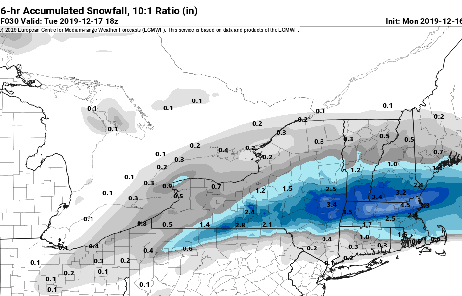
yup...not only are they garbage to begin with but add p-type issues into the picture and they become worse than garbage. Only thing perhaps realistic about that is the potential max area
Just now, dryslot said:Some had laughed at the GFS but it has been pretty steadfast BL issues not included bringing this pretty far north from being the outlier to most all the others moving towards it.
That should have always been a player on the table...scenarios like that are not uncommon in these setups

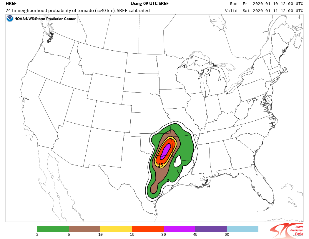


January 10-11 Severe Weather Threat
in Central/Western States
Posted
It’s very unstable ahead of main line with excellent shear. As forcing increases farther East I would watch the next 1-2 hours for discrete development. It’s still relatively early in this event...biggest potential was never really until a bit later on. Outflow from this line could be a major focal point moving through these next several plus hours