

weatherwiz
-
Posts
79,820 -
Joined
-
Last visited
Content Type
Profiles
Blogs
Forums
American Weather
Media Demo
Store
Gallery
Everything posted by weatherwiz
-
 Even if the 6z Euro "verified" there would be more precip northwest of where it is indicating
 -
The 6z Euro I don't think looks terrible overall. It's not drastically different with the mid-levels than other guidance is. It seems like maybe its a bit more east with H7 than it is east-northeast? I wouldn't worry about the 6z Euro
-
I killed a spider in the bathroom this morning. First spider kill of the season. It was on my sink. Probably came inside to avoid the foot of snow. Unfortunately he wasn't able to avoid the toilet paper that got him. I'm still like the mid-levels for a good chunk of SNE. Obviously that gradient in cutoff is going to be brutal somewhere.
-
GFS is pound town.
-
Think many area going to get crushed.
-
Pounding for BOS too. 35-40 units of omega too. Tampa Bay Lightning may not be the only lightning in Boston Tuesday. Looks pretty gusty too as Tuesday morning progresses.
-
NAM bufkit for BDL...that banding is going to be hellacious
-
Yup...just it, tools. Dollar store tools but still tools
-
Simple: It's best to use 10:1....never It's best to use Kuchera...never
-
Are we going to discuss weather or bicker like 5 year olds??? Putting the damn snow maps aside there's a quite a bit going on with the 0z NAM guidance. It's quite interesting that the NAM is keeping the best fronto tucked much closer to the lows. This probably is why the gradient has shifted south.
-
Does the 3km NAM have some sort of funky dry slot going on? or dry punch
-
can't ask for much more
-
0z looks stronger with the southern stream and faster with the northern stream through 15z Tuesday. It's even closed off again at H5
-
Still the HRRR at the extending but not showing anything funky so that's good to see. I'm wondering about the ratios on the HRRR though...its pretty warm at the sfc...not warm enough for PTYPE concerns but that would be a paste for many. Would certainly see some power concerns, even well into the interior.
-
The HRRR doesn't look terrible at all, just judging by SLP track. Happy to see so weird lows or dual lows. The low is more elongated which may help with a more expansive banding/QPF field? A tighter circulation would introduce potential for more in the way of banded precip? This is where my overall lack of knowledge on winter storm climo bites me in the fanny...I knows its been discussed before about differences between a more elongated low vs. tighter circulation.
-
Took a few longer swigs of beer to prevent hyperventilating
-
Yeah I'm not sure why anyone would want to really do that, that analysis doesn't tell you anything at all. If you're seeing changes I would think you'd want to look at what the root cause is and look for any changes in evolution, structure, lift, etc. Sure the 18z GFS may be "south" but it was more juiced overall. That's a ton of QPF being thrown into some intense lifting.
-
I'm not so sure the difference is north/south as much as it is structural/evolution differences. It's easy to say there is a shift just comparing the snow maps (which is awful) and QPF maps, but there may be much more it to than just shifting.
-
Boston could get smoked. I just realized something...the big storm on 01/07 the Bruins played the Lightning in Boston and SMOKED them. Bruins play the Lightning again this Tuesday...Lightning may not be the only thing getting smoked in Boston Tuesday.
-
Still pretty impressive stuff on the 18z GFS bufkit for BDL. 45 units of omega into the SGZ is pretty wild stuff. I am still a little nervous about getting widespread 12''+ (but did that anyways) given how quickly this race through. Cobb technique does have ratios under the banding around 13:1. If we can get ratios that high then 12''+ should happen
-
I don't think there would be thundersnow. But I usually overplay it so now that I say there won't be we'll have thunder galore.
-
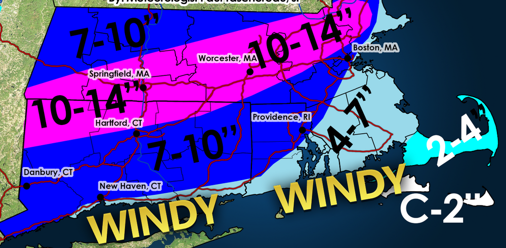
Not as confident out towards the Cape. I always have low confidence out there since I never go into great depth looking. Spent alot of time trying to digest the banding potential and highest total swath. I almost didn't want to include that area and go with a larger range because its going to be very difficult to determine how that evolves.
-
Forecast https://weatherwiz.blogspot.com/2024/02/tuesday-february-13-2024-winter-storm.html
-
I wonder if the NAM is chasing convection here
-
It is. The 3km NAM also aligns more with my thinking currently. I've never been big on the NAM for this type of system and was just more curious with how it would handle banding over anything else. The NAM has been more inconsistent run-to-run than most other models. I am inclined to toss it...but there is always that worry it "sniffs" something out. Working on a snowfall forecast now.


