

weatherwiz
-
Posts
71,087 -
Joined
-
Last visited
Content Type
Profiles
Blogs
Forums
American Weather
Media Demo
Store
Gallery
Posts posted by weatherwiz
-
-
5 minutes ago, CoastalWx said:
GFS really nails HFD to BOS and NW with decent fronto I think.
GFS looks damn good. Interesting with H7 though...doesn't seem to develop a closed off circulation until its well east. But that 850 low track is damn perfect for that corridor of HFD to BOS
-
8 minutes ago, Typhoon Tip said:
is there a graphic for dummies seasonal snow 'normals' product out there? yeah yeah one can search the web themselves but if anyone has that link off hand ...
going into the internet and searching for that sort of thing is far less successful now that the internet has become something other than shared information, rather an enterprise for economic ambition and petty greed. it just makes one angry -
I'd be curious if something exists as well. I'm sure something has too. This is where I wish I knew Python and had the brain for that stuff. All you need is to gather data and then you can create anything you want.
-
I think BDL is like 15'' below the seasonal average for snowfall. That deficit could be eliminated.
-
2 minutes ago, ORH_wxman said:
I've become more and more disillusioned with clown maps...they are lazy and often too wrong...looking at mid-levels and soundings is way better.
That's exactly how I feel. When they first became a thing they were fun to look at and interpret them but I seriously think they are a detriment to the field. When I was at school and there were winter storm threats the first thing most everyone did when the models came out were go right to the snow maps. It's really sad. At least for me, part of the storm enjoyment is the hardcore analysis and assessment.
-
2 minutes ago, ORH_wxman said:
This is poundtown look at H7
This is so much more visually appealing and stimulating than a snow map

I'm thinking of calling a congrats Kevin on this one.
-
2 minutes ago, Brian5671 said:
Better come down heavy or it's alot of colder surfaces type accums
Temps will be more of a concern along eastern coastline like Will said, maybe even along coastal CT but ultimately temperatures are going to be tied into precipitation and rates as well. If we're getting crushed with banding or heavy precip its going to be snow. But I think there needs to be a bit more thought about power outage potential.
-
7z NBM has BDL right around 33 for much of the storm and BOS mid 30's during the pre-dawn and then like 34-35 for the storm.
-
1 minute ago, CoastalWx said:
Hrrr is a torch still. BL blows which has been my worry all along. But I’m a Debbie.
yeah just looked at that lots of 33-34

-
HRRR looks like a crusher from BOS to HFD to DXR
-
 2
2
-
-
6 minutes ago, allgame830 said:
Agreed. Also the EPS mean was better
Even if the 6z Euro "verified" there would be more precip northwest of where it is indicating
-
2
-
-
The 6z Euro I don't think looks terrible overall. It's not drastically different with the mid-levels than other guidance is. It seems like maybe its a bit more east with H7 than it is east-northeast? I wouldn't worry about the 6z Euro
-
I killed a spider in the bathroom this morning. First spider kill of the season. It was on my sink. Probably came inside to avoid the foot of snow. Unfortunately he wasn't able to avoid the toilet paper that got him. I'm still like the mid-levels for a good chunk of SNE. Obviously that gradient in cutoff is going to be brutal somewhere.
-
-
1 minute ago, DavisStraight said:
What are we looking at Paul?
Think many area going to get crushed.
-
 1
1
-
-
Pounding for BOS too. 35-40 units of omega too. Tampa Bay Lightning may not be the only lightning in Boston Tuesday. Looks pretty gusty too as Tuesday morning progresses.

-
2
-
 2
2
-
-
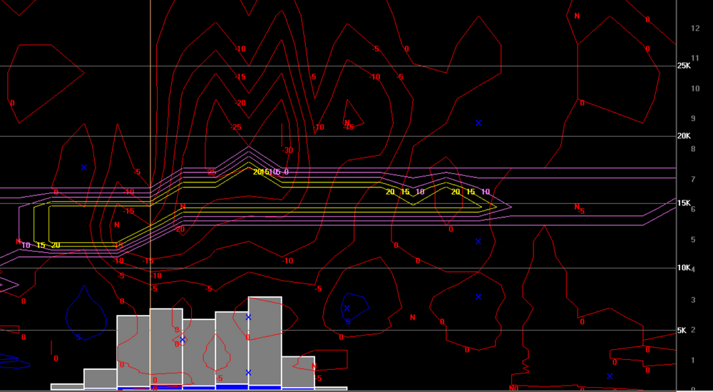
NAM bufkit for BDL...that banding is going to be hellacious
-
2
-
-
Just now, 40/70 Benchmark said:
They are tools....up to the forecaster to make a forecast.
Yup...just it, tools.
Dollar store tools but still tools

-
 2
2
-
-
Just now, moneypitmike said:
I have no idea when to use that vs 10:1
Simple:
It's best to use 10:1....never
It's best to use Kuchera...never
-
5
-
-
Are we going to discuss weather or bicker like 5 year olds???
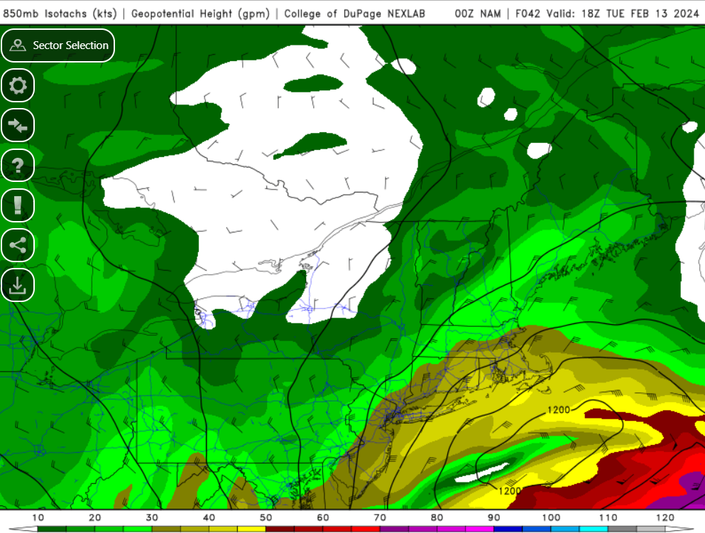
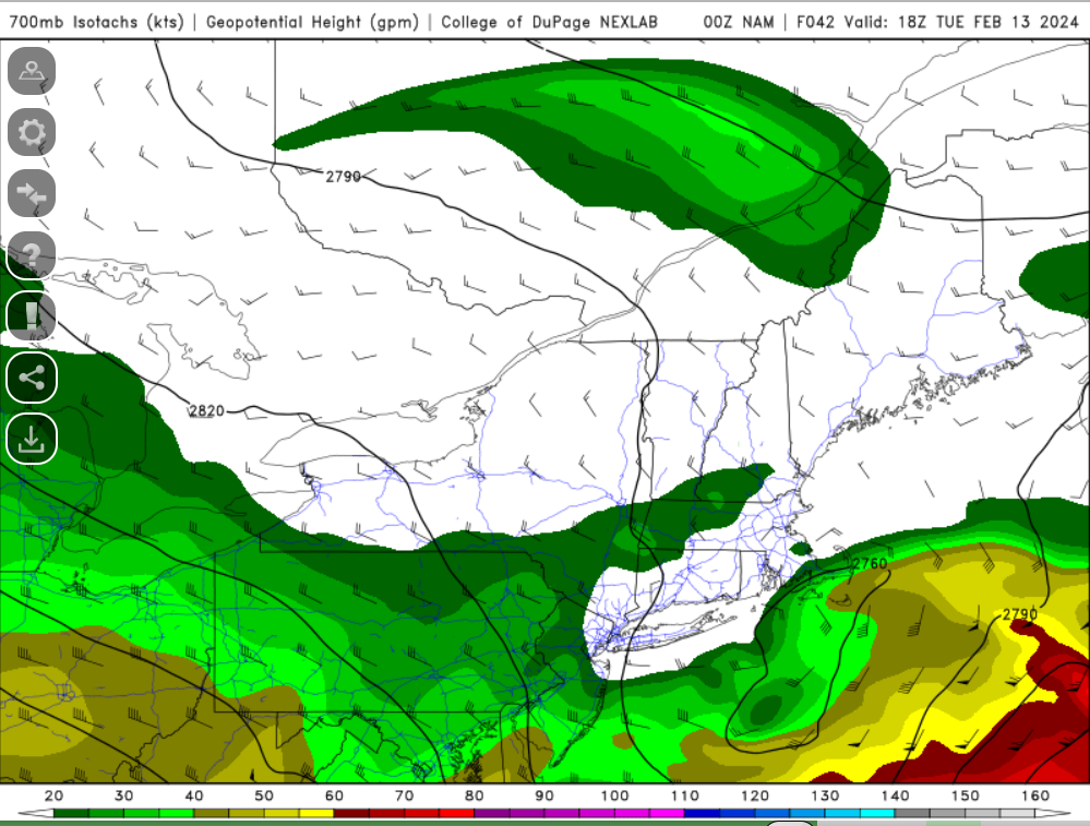
Putting the damn snow maps aside there's a quite a bit going on with the 0z NAM guidance. It's quite interesting that the NAM is keeping the best fronto tucked much closer to the lows. This probably is why the gradient has shifted south.
-
1
-
-
Does the 3km NAM have some sort of funky dry slot going on? or dry punch
-
1
-
-
-
0z looks stronger with the southern stream and faster with the northern stream through 15z Tuesday. It's even closed off again at H5
-
2 minutes ago, DavisStraight said:
Ill take this

Still the HRRR at the extending but not showing anything funky so that's good to see.
I'm wondering about the ratios on the HRRR though...its pretty warm at the sfc...not warm enough for PTYPE concerns but that would be a paste for many. Would certainly see some power concerns, even well into the interior.
-
The HRRR doesn't look terrible at all, just judging by SLP track. Happy to see so weird lows or dual lows. The low is more elongated which may help with a more expansive banding/QPF field? A tighter circulation would introduce potential for more in the way of banded precip? This is where my overall lack of knowledge on winter storm climo bites me in the fanny...I knows its been discussed before about differences between a more elongated low vs. tighter circulation.
Following a Miller A/B hybrid type coastal potential, Feb 13th ... As yet untapped potential and a higher ceiling with this one
in New England
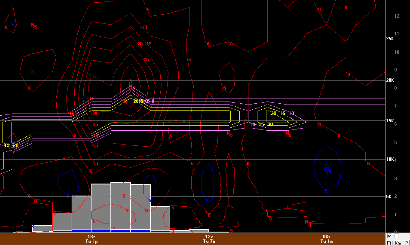
Posted
12z NAM bufkit for BDL. Confidence certainly increasing we're going to see 2'' per hour rates and maybe even upwards of 2.5''. Can't ask for a better signature than this.