

weatherwiz
-
Posts
70,757 -
Joined
-
Last visited
Content Type
Profiles
Blogs
Forums
American Weather
Media Demo
Store
Gallery
Posts posted by weatherwiz
-
-
5 minutes ago, STILL N OF PIKE said:
January averaged above to normal there just looking at the NOAA jan Temp color anomaly map so I can’t see it being close to the the coldest
coldest and snowiest doesn’t usually go together in a cold pattern- winter wonderland land , I would guess coldest is also usually drier
I'm pretty sure January was solidly below-average for Anchorage. They had some prolonged stretches of extreme cold.
-
8 minutes ago, Typhoon Tip said:
Coldest?
I thought it was just snowy...
could be wrong...thought I had come across something recently that it was one of their coldest to.
-
Certainly not happy with this forecast at all. Maybe it looks “fine” for Connecticut but an absolute disaster along the Mass Pike area and I essentially pulled the plug and called bust for Connecticut Monday evening.
now ultimately one could say all I had to do was just shift this down some miles and tighten the gradient. If I had more time/energy I would have made an updated map but l would have not made those changes. I would have went significantly less for Connecticut and maybe do 4-7” southern and 2-4” so it would have been much worse if I did something so this map makes the forecast better than it would have been.

-
 2
2
-
-
What a winter for Anchorage. One of their coldest/snowiest on record then they roll in with a daily record high yesterday. They must be jumping for joy...unless they like the cold.
-
11 minutes ago, mahk_webstah said:
it is an impressive system as it comes thru the upper midwest. I know they lose some juice sometimes coming across the mountains, but sometimes they maintain themselves more than expected, and that helps the Atlantic get involved sooner.
There is a narrow, but large swath of WWA's and even some winter storm warning's along the expected path of this clipper so we'll certainly want to see how that ends up performing.
Something else to watch is whether the core of the system passes over the Great Lakes as sometimes that can provide the system with additional moisture.
-
1
-
-
1 minute ago, ORH_wxman said:
It’s going to be a relatively fast band of snow for anyone south of MA/NH border because we’re south of the low track…so we’ll get the WAA burst in front of it and then it dryslots.
But yeah, some of these soundings look nice and if they continue to look like that tomorrow, then I could see a quick 2” in spots. But it could also end up a bit shredded if that vort trends a little north. We want to root for that vort to dig a little more
Yeah you can see the dry slot on guidance punch right into SNE after that quick WAA burst potential. I think there is room to dig that vort a bit more given the jet streak hasn't yet rounded the base of the trough as it is crossing NNE but that flow is pretty fast and the digging may happen too late for us.
I'd watch for some advisory snows in southwest Maine into parts of New Hampshire. There also looks to be a bit of an inverted trough signal.
-
2 minutes ago, ORH_wxman said:
GFS actually has a nice burst of omega right in the DGZ tomorrow night over MA including BOS. I don’t know if it’s correct but that would prob drop a couple inches.
NAM has a similar look on the soundings but a bit more paltry on QPF.
I think the QPF is being underdone. Dynamics are pretty impressive and RH fields look good (though I didn't look at any soundings so maybe they are showing some dry layers). But that is a potent H5 jet streak moving in, looks like the nose of it coincides with the best lift/forcing too. I would anticipate precip could break out across much of the region.
-
1
-
-
19 minutes ago, brooklynwx99 said:
there is no support for that, so there is no reason why I would do that... there will be opportunities for snow through the 25th, then a hiatus until perhaps mid-March? the evolution has certainly changed for the worse, no mincing words there. i don't just make shit up
however, no reason to be an asshole about it, either. i also wasn't the only one getting excited about the upcoming pattern. there was widespread excitement about it. it made sense in so many ways, but the storm that dropped 6-12" over a wide swath of the Northeast (which you persistently shit all over, mind you), "ruined it." i guess it's ok that the classic pattern got ruined by a SECS. one in the hand is worth two in the bush
Don't even respond to them. The value and knowledge you bring is immense. It's a refresher to be able to divulge deep into the meteorology and not just scroll past 1000 snow maps 300 hours out. When we're discussing patterns and potential nobody is guaranteeing anything will happen, if people are taking it that way that is their issue. It's meteorology 101 that when you're looking medium range and beyond to gauge the pattern and use knowledge of how those patterns have performed historically. But they know this...they just like to troll.
-
5
-
-
2 minutes ago, mahk_webstah said:
NAM shows maybe .15-.2 for up here. That could be 2-4" I'm eager to see what other meso guidance gives later today and overnight.
I would not be surprised to see mesos continue to beef up a bit more throughout the day. I haven't look in tremendous detail yet to see if this is something which will be a larger, more uniform precipitation shield or something that is more along the line of scattered-to-numerous squalls. I think the HRRR may have a solid idea of a more uniform precip shield further north, closer to the vort with squalls from PA through SNE.
-
1
-
 1
1
-
-
1 minute ago, WinterWolf said:
That would be nice…add to a thick pack here. Cold deep winter feeling morning here with fresh snow cover, and a breeze that was adding to the feel.
Yeah I stepped outside like 30 minutes ago to grab a package...it certainly felt like winter. While I don't have much of a snow pack here I am loving today. Despite the cold/wind the sun makes it much better.
-
Tomorrow night could certainly overperform I think. NAM has the s/w amplifying as it moves across the region. Some pretty steep lapse rates involved too. Could be some hefty snow squalls. Maybe even some thunder/lightning across Pennsylvania with squalls which could propagate across southern New England. I could see some spots picking up 1-2''.
-
2
-
 1
1
-
-
1 hour ago, dendrite said:
Sounds like a good time to install.
I just uninstalled my bedroom A/C the other day
-
Working on a little (well shouldn't say little it will be a bit long) blog post doing a bit of a recap. Won't finish tonight because the Bruins are on in 30 min. Probably won't be able to finish tomorrow because doing Valentine's Day dinner after work. Maybe I can finish Thursday after work before the Bruins game.
-
3 minutes ago, radarman said:
That cannot be right...
that report was from just before 7 AM. They had to get around 6'' or so I'd guess based on surrounding reports.
-
1
-
-
1 minute ago, powderfreak said:
Where are you in reference to like Ryan’s station totals? Big gradient.
I'm in Springfield...the northeastern side of Springfield (about 10 min from downtown).
-
1
-
-
-
Just now, CT Rain said:
15.2" in West Hartford here at the station. Nuts.
WOW!!!!
-
1
-
-
10 minutes ago, codfishsnowman said:
Four down. Light snow and breezy
I was just about to go out and measure but that is what about I was eyeballing.
-
5 minutes ago, Ginx snewx said:
Why I didn't waver. Have to open the hood the check the engine and all signs were positive here.
Exactly. This is why I get so bent out of shape with the snow maps. They're just leading to lazy forecasting. Ultimately, forecasting is a science which requires a great deal of time and effort. Now, I get in today's day and age where everyone is so busy and has so many responsibilities that it's difficult to put that effort in, but we're only hurting ourselves that way.
Fundamentals are important. Take sports for example, you can have the most talent team, best players, but if you can't execute the fundamentals, you aren't winning in the end.
When forecasting, the fundamentals should be applied first and always. If one is going to look at snow maps or QPF and see there is a cut-down, the questions needs to be asked as to why that is and whether it makes sense. When looking back at how all guidance was handling the mid-levels, the evolution of the mid-levels, jet enhancement, the QPF cuts should not have made sense.
I guess though hindsight is 20-20...its always easier said than done in the end, but you can't ignore the fundamentals and forget why fundamentals are important.
-
2 minutes ago, Typhoon Tip said:
I dunno ...
I think this qualifies pretty clearly as a 'saved by the bell' event.
Look, every storm is going to jade some zones. That's just the way it is. I remember back to some whopper storms of lore that shadowed CT. This time they fared better while the typical FIT Ma takes one for the team - so to speak.
It's life.
I'm really vastly more fascinated by the the crazy very late/short range wholesale model failure. It's actually encouraging in some respects, because that means there's still Dec 23 1997, or a Dec 9 2005 possible going the other way. - although I do think there's a bit of a weird model cinema reliance for mood control thing that's evolved over the years, which ironically ... that's tantamount to using an uncontrollable vector as a mood management control - hence the
 . That shouldn't be, but it is what it is.
This storm deserves one helluva case study. Ultimately though, this storm is a prime clear-cut example of why snow maps are garbage but why analyzing "trends" in the snow maps is pure garbage. When it comes to modeled QPF, I feel like models have improved on this significantly over the past 10-15 years but this was probably a case too where analyzing QPF trends was probably not a great idea.
Despite what the Euro was doing, the mid-level presentation argued for a crushing along and south/east of I84. I think dendrite mentioned it earlier, but models can often struggle with QPF under the banding signal. I honestly think all the clues were still there for a crushing. Even with the lower QPF, forecast soundings were still showing great lift into the DGZ. Saturation was not an issue so naturally lift into the DGZ was going to produce snow.
I believe we are also in the entrance region of the ULJ.
-
1
-
-
1 minute ago, Damage In Tolland said:
Going to be some 15+ amounts
I guess the 15-18'' I mentioned you could get may work out after all

-
Must be sucking subsidence here or something. crappy snowgrowth and tiny flakes.
-
Just measured 2''...may even be a bit more
-
Very good snowgrowth here. Coming down decently too. Might go our for a measurement at 9
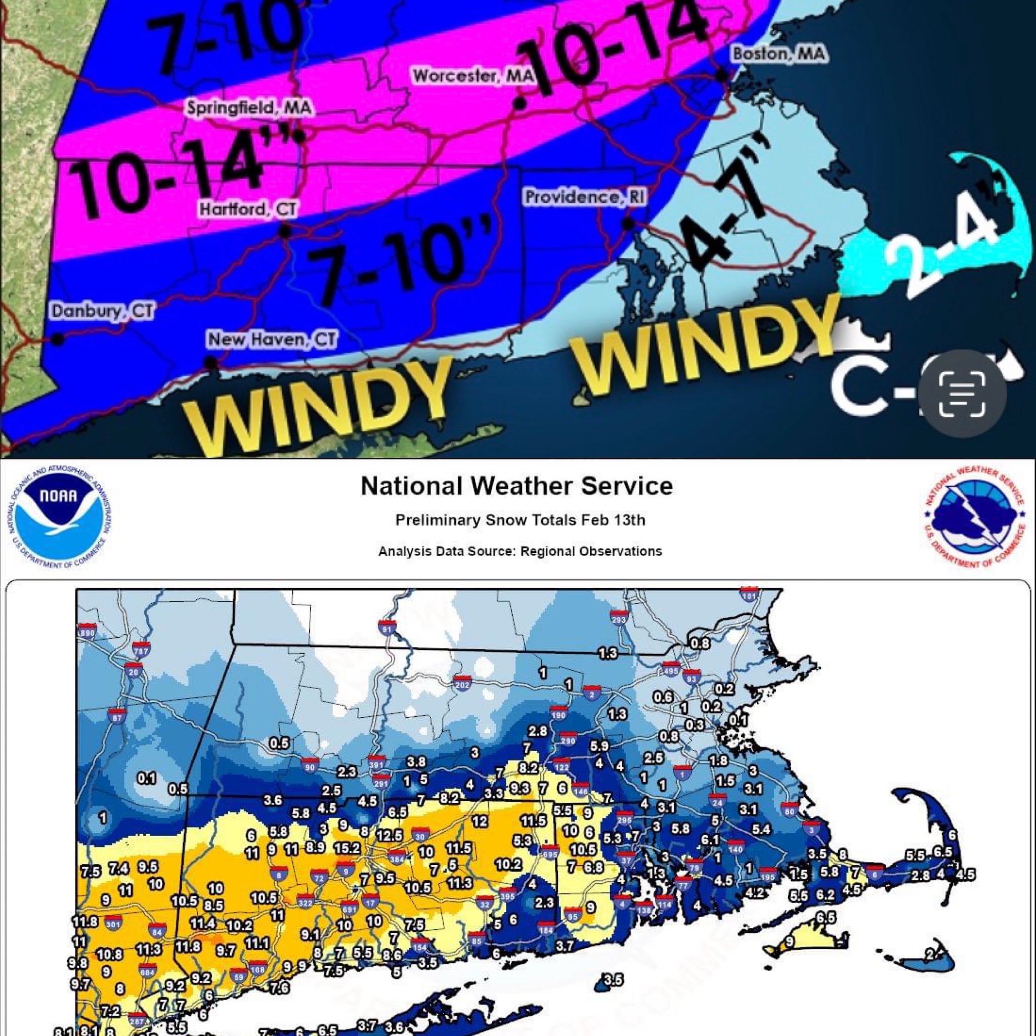
Following a Miller A/B hybrid type coastal potential, Feb 13th ... As yet untapped potential and a higher ceiling with this one
in New England
Posted
Yeah right. What a brutal place to live really. Get hardly any thunderstorms, 90% of the state could be in the lower 80’s and they’re still in the 60’s. Awful