

weatherwiz
-
Posts
71,102 -
Joined
-
Last visited
Content Type
Profiles
Blogs
Forums
American Weather
Media Demo
Store
Gallery
Posts posted by weatherwiz
-
-
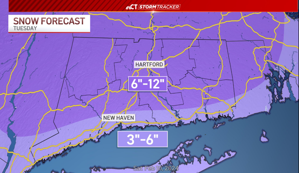
I’m thinking like 12” for me. Not 11.5, not 11.8, not 10.2, not 13.1, not 12.1”…but a nice solid foot
-
 3
3
-
 1
1
-
-
3 minutes ago, Patrick-02540 said:
I agree. Surprises, surprises. All upside, though.
For some yes…but I think there will be some downside surprises as well. It’s just natural in this type of setup.
-
2 minutes ago, ORH_wxman said:
Much less impressive aloft that run but that’s gonna happen. It’s why we’re not forecasting 1-2 feet. But I think the general idea of a favorable track puts a floor of about 7-8” there. Exact dynamic evolution still TBD which will determine whether it’s 8-10” or 12-18” in your area.
If that banding materializes quick enough I think Ray has a good shot for 15” or so. This one will have lots of surprises, on the high and low side. It will be what it will be
-
 1
1
-
-
Well considering I may get a foot of snow and wet snow I finally uninstalled the A/C in the bedroom.
-
2
-
-
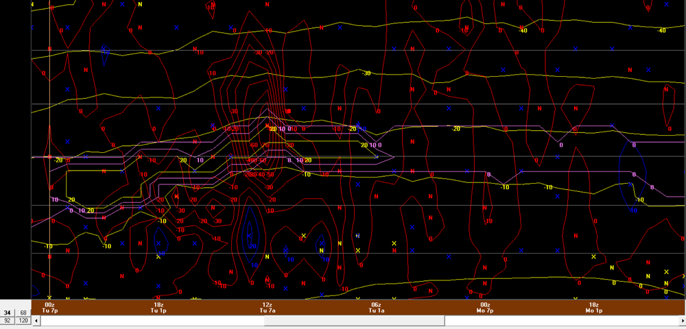
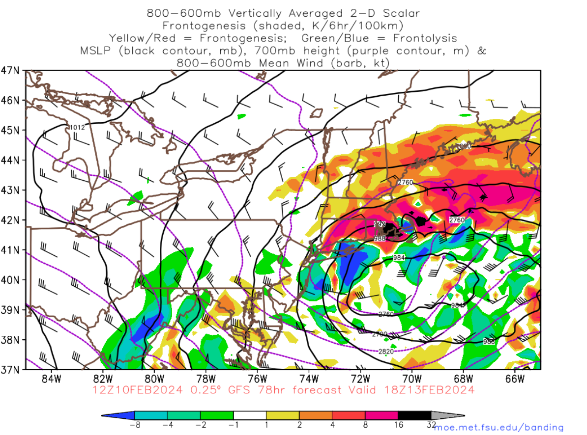
BDL 18z GFS bufkit...holy crap.
-
1 minute ago, CT Rain said:
Here's our first call. Only thing I don't like about the 18z GFS is that it brought the 700mb low a bit farther north. Have to watch that south of the Pike I think.
Yeah there's alot with the 700 low that has me nervous. I think this is going to be a nice storm but still lots of questions to resolve.
-
I'm not sure how I feel about these elongated llvl + mlvl lows. This is going to be an insanely difficult forecast. There will be busts in the higher direction and the lower direction I think and I'm not even sure how you portray that within a forecast.
-
1
-
-
6 minutes ago, WinterWolf said:
No way to pinpoint exactly where this sets up, especially at this stage. ‘13 in the February blizzard, the death band was forecast to set up over eastern/northeast areas, and it came back this way. That was not forecast even the day of. So I mean we can take a guess of course, but in the end it’s just a guess.
6 minutes ago, Sey-Mour Snow said:Wait another cycle and it will be somewhere totally different . Last run 700mv low was in central Jersey . Could either go back south or end up over BDL next run
Yes, there is a great deal of uncertainty with it and there is no way to know for sure right now exactly where it holds up. That's why I've held off on making any type of forecast at this point. But what I'm looking at is as we get closer, how will the modeled band be in relation to what occurs? My thinking is at verification time, the banding is going to end up being northwest of where the models are pinpointing. Looking at where the models show the highest QPF axis 12 hours out and saying that is the sweet spot may not work out that way.
-
Just now, 40/70 Benchmark said:
Only 6 hour intervals...12Z

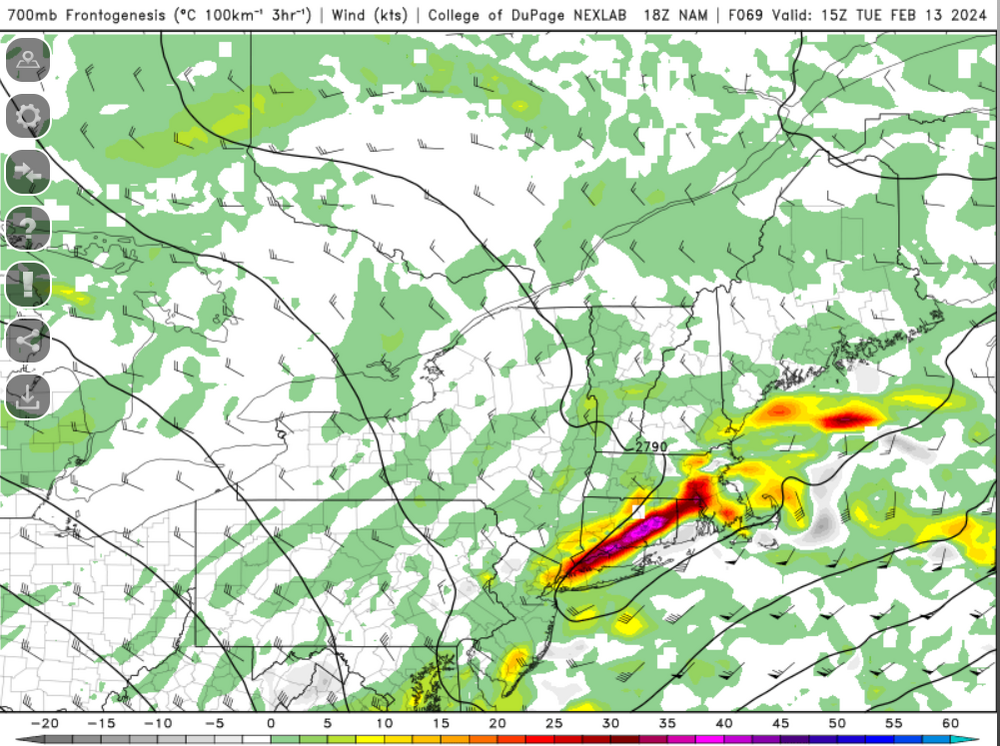
I really hope there won't be much subsidence south of the band. Haven't divulged too much into those details yet but that is always a concern. I am also a bit nervous by this placement b/c the most intense banding (I think in this case) would be displaced towards the northwest side of this fronto...so the highest totals would be like S VT/S NH....then south of there could have several different issues going on.
-
1
-
-
Just now, CoastalWx said:
It should move pretty quick, I think
yeah that's what I'm thinking...that's why I think it is going to be difficult to exceed a foot with this, though not impossible. Right now though I'm thinking 10-16'' for max zone but I'll do a forecast tomorrow.
-
Just now, 40/70 Benchmark said:
The demon-death band is just NW of this H7 fronto

what does 15z look like?
-
bufkit has some decent winds down at HVN
-
1 minute ago, ORH_wxman said:
NAM starting to figure it out. Still south but not total fringe jobs like 06z/12z.
boom
-
1
-
 1
1
-
-
Does anyone who have Weatherbell (or maybe Storm vista) have access to EPS at the 700mb level? Weathermodels doesn't have it but I am curious to see what the EPS do with the mid-levels
-
Art least for my spot, I feel somewhat confident I may end up in the range of higher totals from this but I'm getting a bit worried the most intense banding is going to be even north of me.
-
Trying to get a feel for ratios right now. Obviously the farther south you go, the ratios won't be as great but I think ratios for the most part should be relatively good for most. Maybe right around 10:1 for most and then under the intense banding, maybe 13:1 to as high as 15:1? Again, where sfc is a bit more marginal, ratios probably a bit less than 10:1.
-
I'm in the general thunderstorm line

-
1
-
-
17 minutes ago, Sey-Mour Snow said:
I agree, that was just the high end tease of what’s possible ..
I didn't even see your post...we must have posted at the same time

But my post wasn't in reference to what you were saying at all, the way the posts lined up it looked like I was refuting your post but that wasn't the case.
I agree with you, that is the high end tease...maybe we can slow this down a bit and achieve that.
-
1
-
-
This thing is hauling. It may be difficult for anyone to achieve more than a foot. I was thinking a 12-16 or 12-18 was certainly doable but that is going to be very difficult I think.
-
1
-
-
4 hours ago, Ginx snewx said:
I do it everyday. Got another foster pup. Comet another lab mix. 4 months old.

Adorable

-
1
-
-
1 minute ago, ORH_wxman said:
Yeah tossing the mesos until we’re another 24 hours closer.
The only use mesos will be with this one is helping pinpoint banding and intensity of banding.
-
4 minutes ago, MJO812 said:
So you think this will be amped ?

I am starting to like the increasing consistency with the GFS/Euro, at least with some of the pieces involved. Not sure or really interested what the snow maps or showing. Based on how this would likely evolve, however, I would think that the best banding and heaviest snow is going to be quite north and west of the sfc low...so even if there was a track which favored say NYC or the south coast, the heaviest banding would likely be north. I think things tighten up too late to really get the banding to collapse south towards the center until eastern areas.
-
At this time I'm leaning towards an interior northeast Massachusetts for jackpot zone extending into northeast Connecticut (but not quite to tolland).
-
3
-
-


Following a Miller A/B hybrid type coastal potential, Feb 13th ... As yet untapped potential and a higher ceiling with this one
in New England
Posted
Was just looking at 6z GFS bufkit for BDL and its pretty wild. Should see a good 3-4 hours where rates are anywhere from 1.5''/HR to as high as 2.5''/HR.