

weatherwiz
-
Posts
71,645 -
Joined
-
Last visited
Content Type
Profiles
Blogs
Forums
American Weather
Media Demo
Store
Gallery
Posts posted by weatherwiz
-
-
17 minutes ago, Sey-Mour Snow said:
I agree, that was just the high end tease of what’s possible ..
I didn't even see your post...we must have posted at the same time

But my post wasn't in reference to what you were saying at all, the way the posts lined up it looked like I was refuting your post but that wasn't the case.
I agree with you, that is the high end tease...maybe we can slow this down a bit and achieve that.
-
 1
1
-
-
This thing is hauling. It may be difficult for anyone to achieve more than a foot. I was thinking a 12-16 or 12-18 was certainly doable but that is going to be very difficult I think.
-
1
-
-
4 hours ago, Ginx snewx said:
I do it everyday. Got another foster pup. Comet another lab mix. 4 months old.

Adorable

-
1
-
-
1 minute ago, ORH_wxman said:
Yeah tossing the mesos until we’re another 24 hours closer.
The only use mesos will be with this one is helping pinpoint banding and intensity of banding.
-
4 minutes ago, MJO812 said:
So you think this will be amped ?

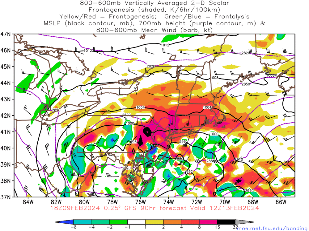
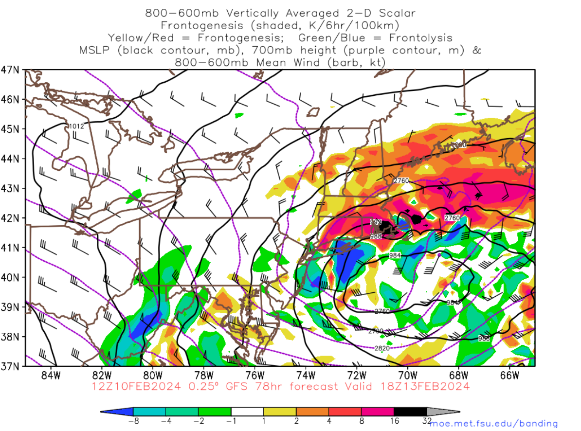
I am starting to like the increasing consistency with the GFS/Euro, at least with some of the pieces involved. Not sure or really interested what the snow maps or showing. Based on how this would likely evolve, however, I would think that the best banding and heaviest snow is going to be quite north and west of the sfc low...so even if there was a track which favored say NYC or the south coast, the heaviest banding would likely be north. I think things tighten up too late to really get the banding to collapse south towards the center until eastern areas.
-
At this time I'm leaning towards an interior northeast Massachusetts for jackpot zone extending into northeast Connecticut (but not quite to tolland).
-
3
-
-
-
4 minutes ago, 40/70 Benchmark said:
Whiffle ball with the kids, weenie ball with the freaks.
I actually should take some time and pull one of Steve's favorite chores...picking up dog poop. There's a few month surplus out in the backyard.
-
 1
1
-
-
1 minute ago, HIPPYVALLEY said:
I'm mildly concerned about 8 hours of arctic sand N of RT 2.
probably tomorrow start paying closer attention to snow growth, lift, snow ratios, etc. I feel like there are going to be alot of challenges with this one. Several red flags and several green flags (or whatever is used to refer to something good lol).
-
1
-
-
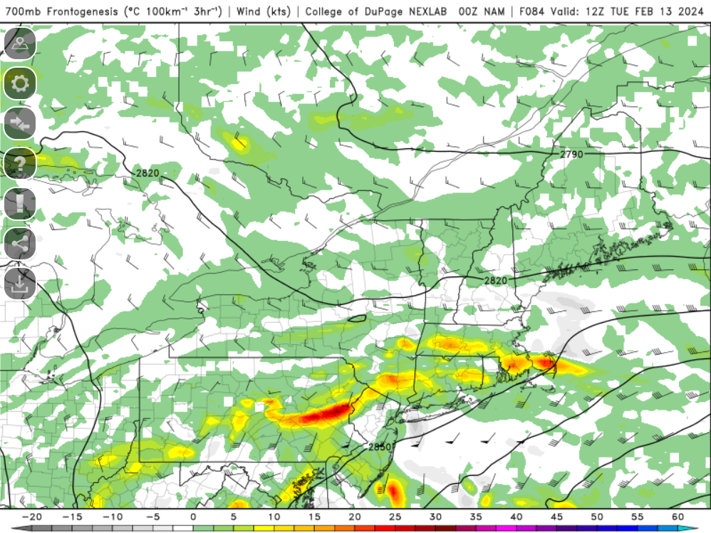
The NAM would deliver the goods to many.
-
Tomorrow is going to be a fun day. With temperatures around 60 I'm going to sit outside and watch the Bruins game...all while tracking a big snoowstorm...love it!!
-
5
-
-
2 minutes ago, RUNNAWAYICEBERG said:
Right. The temp range is static but not the layer where the range is located.
Correct. sorry...misunderstood what you were asking.
-
Just now, RUNNAWAYICEBERG said:
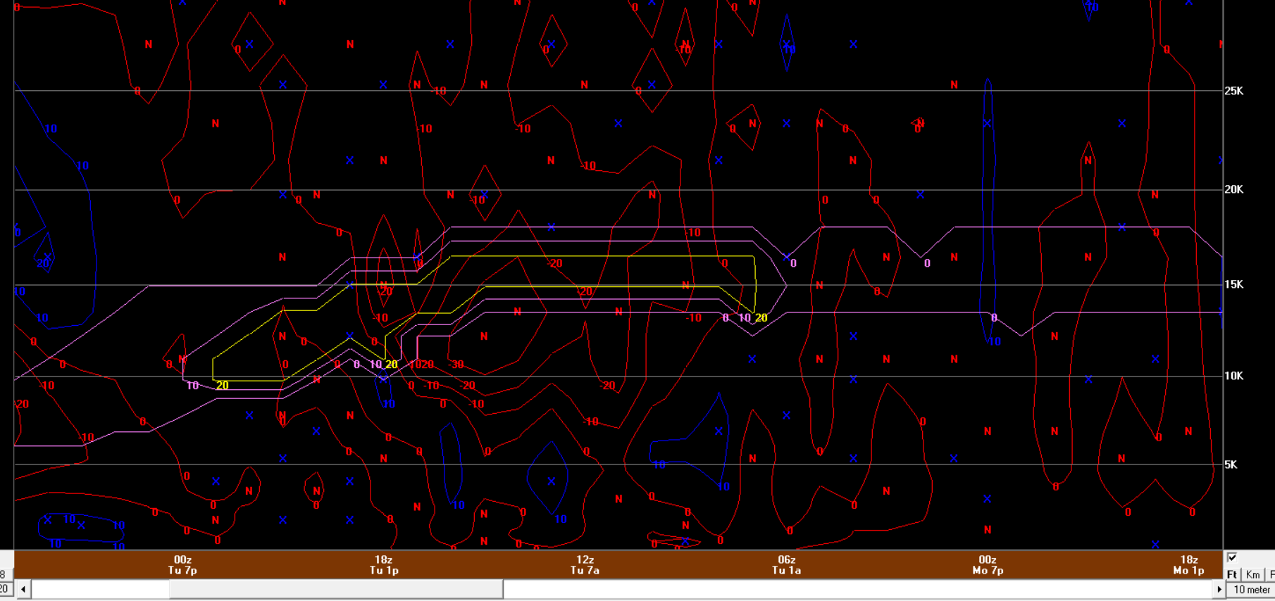
And time is right to left, weird but ok, and the SGZ lowers as the atmosphere saturates? I always though it was stagnate.
The SGZ can vary. The snowgrowth zone is denoted within the level of the atmosphere in which temperatures range between -12C and -18C. This is the temperature rage where the best dendrites are produced. So in a colder airmass, the bottom of the snowgrowth zone will start at a lower height level within the troposphere. So you're seeing the SGZ lower there because the airmass is getting colder.
Yes, time goes right to left.
-
 1
1
-
-
Just now, RUNNAWAYICEBERG said:
I never know how to interpret these.
the purple/yellow box denote the snowgrowth zone (I always forget though what the difference between the purple/yellow are).
The red contours are omega (rising motion). you want the best omega right within the snowgrowth zone (crosshair signature). This is a great signal for heavy snow with intense rates.
-
BDL - I'll take this come verification

-
To Tip's point about getting totals that high, that band will be zipping along
-
16 minutes ago, Typhoon Tip said:
By fall rates? perhaps .. I'm thinking 12" might be more common due to speed of system translation. Maybe a couple 13.5ers for bragging rights.. which technically justifies the top side of that range but the interquartile density/distribution is 12" Now, someone pops one of those zomb 7" hours with a couple of CG .. that makes that easier. But I'm not sure CSI is very factor-able being on the left exit-left entrance side of the jet.
12" in 4 hours is good stomp and I don't see the heaviest axis lasting very long in any location ... in and out.
It's likely to go down hill outside really fast. You see it start snowing so you run out to the store, and by the time your coming home your wondering if that was such a good idea type visibility problems. The lifting mechanics will move in/through quite fast
The speed of the storm could certainly be a factor in obtaining those higher ranges. That always needs to be factored in when thinking go big or go home type ordeals. Not setting that potential into stone yet, but something I think is viable if everything falls together correctly.
11 minutes ago, 40/70 Benchmark said:Discounted.
IDK...probably more likely it can be discounted but I'm not going to do so just yet. I'm giving until 0z/6z guidance before totally dismissing it. I mean even at this stage we're seeing large spread within the northern stream and still some differences with the southern stream.
-
6 minutes ago, RUNNAWAYICEBERG said:
There is the possibility of it being shredded but I’m more concerned of the best goods being north of 84, again.
Yeah I would certainly be concerned for that as well if I were you. But given how the band should be pretty large, hopefully that would result in your area getting into it too. Still lots to iron out through the weekend.
-
10 minutes ago, RUNNAWAYICEBERG said:
The op is on the nw cluster.
While I am getting excited I am still nervous that this could end up south and we get skunked. I don't think that should be discounted yet.
-
1
-
-
I'd watch for Monday to be a bit colder than guidance, especially if thick cloud cover gets in here earlier in the day.
-
1
-
-
I think a 12-16'' max zone is absolutely doable with this and I agree with Kevin in that it should be entertained.
-
2
-
-
The differences in the speed of the northern stream between the 18z/12z are insane.
-
This is almost over my fanny but I'm too skinny to get directly over my fanny. Not bad!

-
1
-
-
One thing that may help alot of people out with this is that deform band isn't going to be some narrow zone. It's going to be a pretty large (in terms of geographic coverage) band.
-
3
-


It was a Flop... February 2024 Disco. Thread
in New England
Posted
I'm in the general thunderstorm line