

weatherwiz
-
Posts
71,646 -
Joined
-
Last visited
Content Type
Profiles
Blogs
Forums
American Weather
Media Demo
Store
Gallery
Posts posted by weatherwiz
-
-
1 minute ago, 40/70 Benchmark said:
Given the N stream's reluctance to completely join the fray, its commital to abandon ship altogether has ascended this from a marginal, amorphous bag of unrealized potential to a relatively short duration, high impact ordeal.
Indeed, the duration of the storm as a whole may not be that long, but the period of high intensity could be pretty wild. I don't mind having this arrive during the daylight others either, don't have to kill yourself staying up all night and losing sleep

-
 1
1
-
-
Been trying not to have much in the way of excitement or expectations for this yet given how much uncertainty there has been but looking over things this morning I am starting to get quite excited. Still lots to iron out and I hope we get some more consistency but you can't hate what the past 24 hours have looked like in the modeling field.
-
4
-
-
1 minute ago, 40/70 Benchmark said:

@dendrite can you add an angry emoji to the reaction list?
-
 2
2
-
-
6 minutes ago, RUNNAWAYICEBERG said:
Wizzy would like a clown map.
I'd rather have 37 and drizzle on July 4
-
3
-
-
1 minute ago, Greg said:
I did indicate 1983 as you saw I stated. Depends upon one's definition of a big storm. and what area coverage.
This is a great point, but this also raises conflict. If you're discussing this stuff taking a scientific approach, you can't have a million definitions and criteria otherwise there is just mass confusion. I suppose though having a ton of different definitions is fine, but the criteria needs to be established and there also needs to be sound reasoning.
-
Just now, 40/70 Benchmark said:
Most strong el Nino winters have a KU....
It still boggles my mind, even after all the discussion this summer, how some still think that a strong EL Nino mean no snow or little snow. We have had strong EL Nino's with plenty of snow. There are also plenty of EL Nino's with lots of snow and plenty with little snow.
-
3 minutes ago, Ginx snewx said:
That and hills and trees. Living near the ocean however rivals the Midwest for winds.
True...to some extent the ocean can certainly give the Midwest a run with the winds. I would love to experience a true Midwest blizzard though, I would have to think its something that would be more epic than what we ever see here. I mean how often do we see portions of 84/91/95 close due to a winter storm? Portions of I80, I90, I94, I29 will close multiple times per winter and sometimes for multiple days. Conditions just get too dangerous to even have plows going out.
-
It would be sick if we got the winds they did in the Great Plains with their major storms. That's what really separates their storms from ours in terms of impact.
-
Thank God for brooklynwx99. It's great to see comparisons at H5 to illustrate differences in either model run to model run or model to model vs. using snow maps to illustrate trends/differences.
-
5
-
-
Well even if this one doesn't work out, at least through much of the remainder of the month both the northern and southern streams look active. I think the northern stream being active in we can get good storms from northern stream alone. I like the southern stream being active, and coincident with the northern stream, in that it offers potential for significant cyclogenesis off the EC. chances will not be limited.
-
5
-
-
7 minutes ago, jbenedet said:
There's still huge discrepancies just on how strong the southern stream vort is, and speed of it,, pretty early on around day 4 nevermind phasing. Kinda shocked by this, actually.
What really sucks about this too is, if these discrepancies remain over the next few days there isn't a heck of a lot we can do. It's not like the error is resulting from sampling or lack of sampling. It looks like its just a result of how quickly the southern stream reaches maturity and exactly how strong the jet streak gets as it rounds the base of the trough and when this starts to occur. There are so many factors which can play into this that we may not know for sure until real-time Monday morning.
-
Just now, jbenedet said:
There's still huge discrepancies just on how strong the southern stream vort is, and speed of it,, pretty early on around day 4 nevermind phasing. Kinda shocked by this, actually.
Yeah the divergence in the southern stream around that time is pretty eye opening.
-
1
-
-
1 minute ago, HoarfrostHubb said:
Just waiting for Charlie Brown to get reeeeaallly close to the football
If we're comparing GFS to that then I would still feel much better having Charlie Brown behind the football than Chad Ryland in terms of our hope for a hit.
-
1
-
1
-
-
Just now, 40/70 Benchmark said:
I think that was the first event in March 2018...I know the first one in that parade was a bust, but it may have been due to rain.
yeah you might be right on that...March 2018. I remember I was in my final semester and I graduated Dec 2018. Long Island got destroyed in that one...I think they got like 18-24'' across the north shore.
-
1 minute ago, 40/70 Benchmark said:
I don't see much of a path to a big snow event for SNE...I feel like its another game of #pickapork...which porking would you like, ie in which direction would you like to be bent? its either going to phase and hit NNE, or not face/succumb to confluence and be a pedestrian event squashed to the south with insuffficent dynamics to overcome a crap antecedent airmass.
I agree with this, I think its either a dumping for NNE or we see a southern track with light snows/accumulations into the region. People need to be really careful with this one and focus on the confluence and forget the model snow maps (and I'm serious with this one). This reminds me a bit of a setup in 2018 I think it was (not saying the setup is similar) where QPF/snow maps were destroying us, even a day or two out, and confluence won. I remember some forecasts for southern CT were like 10-18'' (maybe even more) and we got like 2-3'' in Danbury when I was at school.
Just now, Spanks45 said:GFS might end up winning this one in the end....still out of Nam range, so plenty of time
I have a feeling no one model is truly going to win this one. There has already been so much spread from run-to-run and model-to-model. While this isn't anything new for this stage of the game, I think it's something we continue to see until we're within inside 2 days. I am not sure how the NAM will handle this, but I would suspect it will be the worst of them all (I guess that isn't saying much though).
-
1
-
-
1 hour ago, brooklynwx99 said:
just a note... the GFS is farther south because it has more confluence from the northern stream, not because it's less amplified. it's actually way more amped with the southern stream than the ECMWF
so, although it's farther south, it doesn't seem to be due to its typical bias. for the record, I still think it's wrong, but it has a bit more validity this time since the differences between it and the other models is actually pretty small, and the northern stream can absolutely destructively interfere instead of phasing
I think confluence is going to end up being a large factor in the evolution/outcome of this.
-
3
-
-
8 minutes ago, WinterWolf said:
So why not just discuss there then? I mean it doesn’t matter either way obviously, but it goes both ways on that premise.
That thread gets clogged up with enough crap, at least the crap can be reduced and contained elsewhere. We all know this thread will probably be 40 pages by Saturday...so at least it keeps the Feb thread 40 pages less...which that thread was 40 pages before February even began
-
1
-
2
-
 1
1
-
-
Having this thread is fine, what's the difference if it is discussed here or in the February thread?
-
1
-
-
5 minutes ago, Sey-Mour Snow said:
I agree ensemble storm tracks have been extremely volatile this year. Need to wait this one out until we get multiple cycles of consistency
Phasing events should always be treated in their own category. Phasing is really all about timing. Even if you have spot on consistency for multiple cycles and for multiple days, as you get closer something could muck up the timing. Until the energy within the two streams is being sampled well and models are initializing with consistency and there is a solid understanding of the downstream pattern, these can be a pain. We've seen some storms in the past where it looked like timing wasn't going to work out and then around D3...boom.
-
1
-
-
4 minutes ago, Sey-Mour Snow said:
Faster and less interaction no run to run continuity yet. Much worse for most . We will get something vastly different at 00z I assume
Yup...very hard to gauge any kind of expectations right now. Just too much inconsistency. I wouldn't even put much stock into the ensembles right now either.
-
There are other maps to analyze besides snow maps.
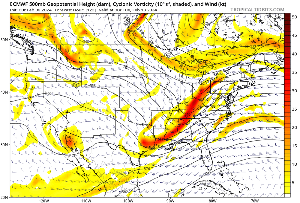
Anyways, here is the Euro at 120. Definite differences versus the GFs with both streams
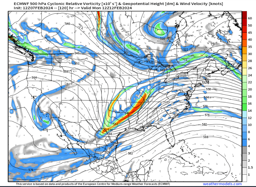
-
1
-
-
What ends up helping everyone out too is how the entire system closes off as it is passing just to our east. Would see some a good deal of dynamic cooling in that scenario and very hefty CCB which would more than likely traverse the entire region. Essentially, if this solution were to verify I don't think I'd complain.
-
 1
1
-
-
Just now, 40/70 Benchmark said:
A later phase is never a bad bet.
Nope...something I'm not going to disregard as probable or possible right now. But details aside, I think where things stand right now.
-
2 minutes ago, ORH_wxman said:
GFS is gonna be warm and zonked.
Would love the phasing to take place later obviously but it's great to finally see something involving a text book phase between the northern stream and southern stream. Not sure what room we have to get a later phasing, but certainly still far enough out to where that is possible, although I imagine we would want to start seeing that signal in the next day or two.


Following a Miller A/B hybrid type coastal potential, Feb 13th ... As yet untapped potential and a higher ceiling with this one
in New England
Posted
The changes in the evolution of both the northern stream and southern stream over the past 24 hours have been astonishing. With the way this looks now I would not be surprised if the deform band ended up farther north than guidance is pinging currently. I guess one thing we really need to hope for too is that southern stream amplifies or digs as so otherwise this could turn into an ugly strung out ordeal very quickly. I am a bit nervous with how things have trended speed wise. Expectations still in check for now.