

weatherwiz
-
Posts
76,438 -
Joined
-
Last visited
Content Type
Profiles
Blogs
Forums
American Weather
Media Demo
Store
Gallery
Posts posted by weatherwiz
-
-
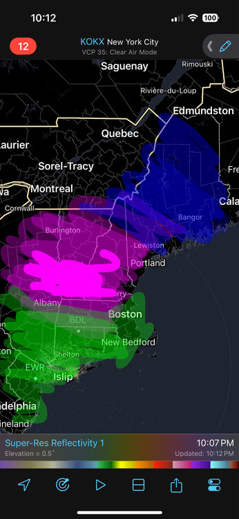
Crazy supercells getting going. Not good for western Kentucky and Tennessee.
-
 1
1
-
-
23 minutes ago, Prismshine Productions said:
Map?
Sent from my SM-S156V using Tapatalk
-
17 minutes ago, powderfreak said:
Move to higher ground watch… in larger basins than normal.
5 minutes ago, ineedsnow said:Helene maybe?
I can’t believe the rainfall totals being spit out by guidance. A widespread 8-12”. Given how much convection will be involved I bet there will be some locations that pull of 20”.
-
 1
1
-
-
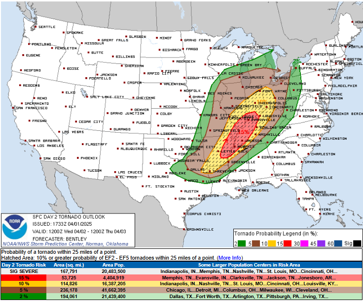
Wow PDS Flood Watch for parts of KY/TN/AR/MS. I don't ever recall seeing a PDS Flood Watch...?
-
Saturday is going to struggle to warm sector. Don't think anyone in New England warm sectors. Sunday most should warm sector but it may take some a while.
-
1
-
 1
1
-
-
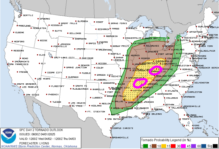
3 hours ago, weatherwiz said:
Actually there might be a few small areas of enhanced tornado potential tomorrow. Wouldn't be surprised if one of two things happen
1) The geographical area of the 10% hatched TOR is reduced and confined to a smaller area.
2) the area remains the same but 15% hatched is added in these areas.
This is much more fun to track versus 30's/40's, clouds and drizzle.
A little off but not bad

-
3
-
-
9 minutes ago, CoastalWx said:
I think the flooding will be the bigger issue by Sunday. Looks like a bad situation.
Yeah this is looking ugly within western Kentucky. I would not be surprised if there were spots that saw 15-20" of rain.
-
1
-
 1
1
-
-
1 minute ago, WinterWolf said:
It ain’t even close to being the same. You need to be in Oklahoma, with an F5 wedge tornado that’s a mile wide, bearing down on you Wiz.
As long as it was in an open field with nobody's homes/businesses in the path would be good with that!
-
2
-
-
Just now, WinterWolf said:
Like Anthony down in NYC…you need to move.
ehhh not really...can enjoy weather from afar

-
I don't think the HRRR is too far off with probably a wintry mix moving across the region during the evening. That's a heck of a surge of WAA. Have to see how quickly the llvl cold scoots out.
-
1
-
-
Actually there might be a few small areas of enhanced tornado potential tomorrow. Wouldn't be surprised if one of two things happen
1) The geographical area of the 10% hatched TOR is reduced and confined to a smaller area.
2) the area remains the same but 15% hatched is added in these areas.
This is much more fun to track versus 30's/40's, clouds and drizzle.
-
 5
5
-
-
4 minutes ago, Typhoon Tip said:
hate to burst any bubbles of grandeur around here but it's still winter
")
That may rub the spring/warm enthusiasm's the wrong way but tough shit. The natural Earth doesn't care about calendars or perceptions, or personal wants and needs and biases thereof... The pattern orientation and genera, along with 30s this and that, ... freezing at night. No, we are not escaped yet.
I'd almost argue that if you could if you were to remove attribution, we would be snowing still - but since we cannot do that ... this is what a winter that won't end looks like, when it is happening in CC
(there! that should piss off the most possible people's sensitivities by using a single post hahaha)
At least we shouldn't have issues warm sectoring for Thursday (well except up north)
-
Just now, CoastalWx said:
Why does it seem like that area into Kentucky has had massive flooding last few years?
It's been pretty ugly there. This week could end up ugly too...this could be a bigger story than the severe weather potential really.
but I guess when you're pooling 60's dews and rich theta-e air into fronts which seem to stall there for multiple days that sets up a terrible recipe. Was it last there they had a stationary front there for like 3-4 days?
-
1
-
-
I wonder how many tornadoes there will be tomorrow. Seems like its predominately linear mode outside of initial development. I also feel like it may not pan out to be anything over the top wild.
-
2
-
-
One month to go!!!! Less than a month actually
-
Tomorrow looks like toaster bath weather. MAV/MET for BOS is 30's. NBM is a little more kind
-
1
-
-
Looked out the window at the right time and saw a nice CG
-
2
-
-
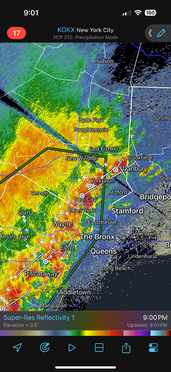
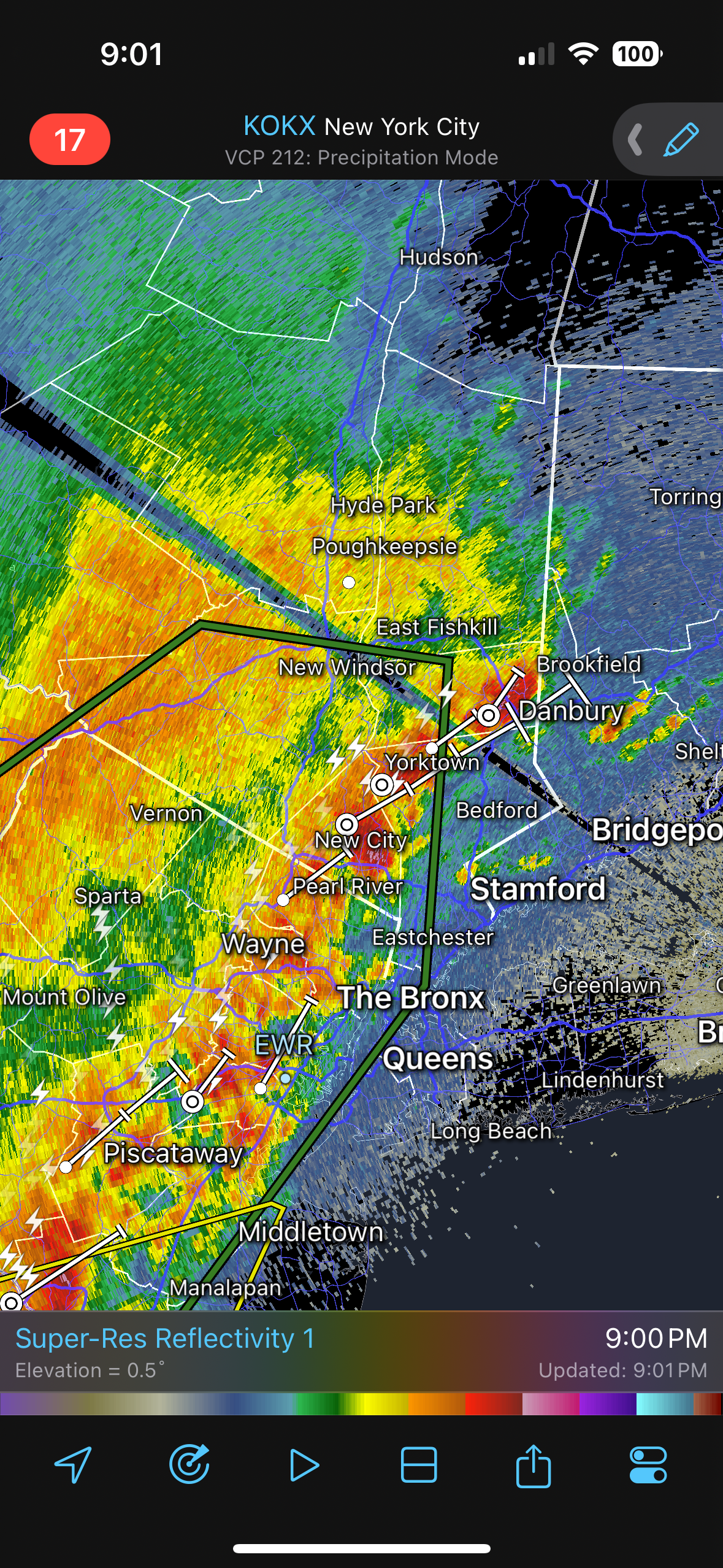
Probably small hail falling between New Fairfield and Brookfield
-
1 minute ago, Torch Tiger said:
hopefully not the best event of the season...

nahh just a pre-cursor
-
We going out like a lion
-
1
-
 1
1
-
-
Turned into a great late afternoon. Now time for some thunder later
-
21 minutes ago, 40/70 Benchmark said:
The primary issue I have seen with your work is that you tend to get lost in the trees and lose sight of the forest, so to speak.......the data is overwhelming as it is for me going back to 1950, nonethless 1870 or whatever the hell you do. There is a paradox that exisits in that on the one hand, we have such a grave dearth of data in terms of sample size, but on the other hand, there is data saturation with respect to the sample that we do work with. Its important to set boundaries so you don't endure "paralysis by analysis" and spend more time sorting data than you actually do forecasting. I have noticed that you tend to exhaust yourself with ENSO composites, which is something that I have moved away from because if anything, ENSO is growing less preavlent as a seasonal driver. ENSO is the foundation of the seasonal house, metaphircally speaking....we have a finite amount of time to complete this seasonal work and if you spend 2 months polishing the foundation, you're going to build an inferior house.
I couldn't agree more with this post. I exhaust myself big time with composites and I need to move away from that because otherwise I am never going to get to the level I want just because I don't have the time to really do so. I only really do that to develop a fundamental background in understanding but it is extremely, extremely time consuming. But I think over the years I've developed enough knowledge/understanding that I don't need to do this anymore but If I knew how to program/code this could be done in a way more productive manner.
But I try too much to break things down so much and try to get as close to a linear correlation as possible which is stupid because when it comes down to it, there really is no or are no linear correlations. And this is what makes the science so difficult. As humans, we are equip to understand/handle linear correlations pretty easily, but getting outside of linear correlations and we struggle...its a skill that can be taught but the path is difficult.
-
1
-
-
8 minutes ago, 40/70 Benchmark said:
I consider ONI, MEI and RONI.
I find the ENS-ONI intriguing, though I think its more designed to highlight ENSO events pre-1950. But it wasn't until I came across the ENS-ONI that I realized there are a ton of different methods and metrics to define ENSO events. Maybe this is good...maybe this is bad but I think this helps us to "think about the box".
I debate though how much I want to involve ENSO events pre-1950. I don't think that data should be discounted, however, when creating composites and assessing it must be understood this data is all re-constructed and there are caveats. While it does seem like there has been a huge change in how ENSO events behave lately its very difficult to make this assertion because data coverage/collection is worlds better now...but even with this there could be inconsistencies, especially with satellite data/measurements.
-
Great thread, hoping to get more involved with the seasonal forecasting this year. I did last year but 2025 was pretty wild. Part of the problem is I get too much into my head. Anyways, I've gone back to the drawing board when it comes to creating ENSO composites. I've read made my lists of EL Nino, La Nina, and ENSO neutral using the ENSS-ONI, ONI, and RONI, however, I am not sure I want to go ahead and create a list breaking down by strength.
Through the journeys and research and studies, there is a whole world of accepted definitions when it comes to ENSO and classifications beyond the typical ONI and SSTA thresholds we're all familiar with. When digging into strength classification I would like to incorporate more of the SOI and MEI into the classifications.

Napril 2025 Obs/Discussion!
in New England
Posted
sleet falling here