

weatherwiz
-
Posts
76,464 -
Joined
-
Last visited
Content Type
Profiles
Blogs
Forums
American Weather
Media Demo
Store
Gallery
Posts posted by weatherwiz
-
-
16 minutes ago, CT Rain said:
Wiz - are we locking in the D6/D7 EML on the GFS?
We see that for another day or two of runs we may be able too

-
 1
1
-
-
Just now, Sey-Mour Snow said:
Damn didn’t expect 79.. very warm again something about the April 15-25th time period were we hit multiple days in the 80s almost every year.
Must be because the lack of leaf out dry grounds?
-
We are just over a week away from the month of May. The snow shovels and snow blowers are put away, trees are budding and blossoming, flowers are growing, and ACs are being installed. We are entering a season of change and pretty soon we'll all be celebrating the three H's. May also begins the increasing risk for thunderstorms as we introduce greater theta-e air into the region with cold fronts making their way through at times.
Looking ahead to the first week of May, it looks like April closes on an unseasonably warm note with strong ridging at 500mb coupled with a cold front approaching at the surface helping to aid in unseasonably warm llvl air with a strong southwesterly flow. While there are subtle hints at some weak troughing across the Northeast to begin the first week of May, independent on any small-scale phenomena, we should begin the month above-average with respect to climo with potential for some over the top warmth given the above-average height anomalies extending well into central Canada.
-
 1
1
-
1
-
-
6 minutes ago, Chrisrotary12 said:
He's love my house then. Last week the temp in the house got up to 77 on the warm day and the oven on. In the summer, the big living room with vaulted ceilings in the low 80s. It's like a greenhouse.
ehhh that is too warm in the house actually lol. Saturday it got up into the upper 70's in the house...was tough to sleep Saturday night because it was so warm. I do like it cool at night because I can just bury myself under the blanket. I don't think this place is well insulated...it gets crazy hot inside, even if its in the 60's or 70's outside and crazy cold in the winter.
-
1 minute ago, Typhoon Tip said:
burst out here about 45 min ago...
61 up from 54 . Sat trends suggest this air mass is being heavily modulated by the sun.
Yeah probably about 30 minutes or so ago got the burst out here. Quite a bit of blue sky and sun now. Temperatures should really shoot up over this next hour, especially given this burst out occurred just prior to prime heating time.
-
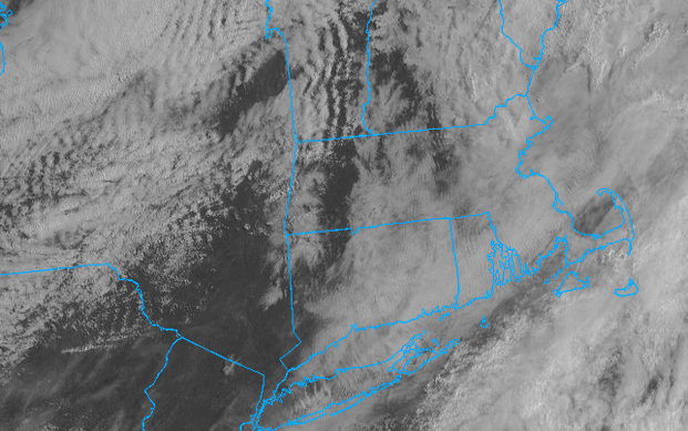
This thick llvl deck absolutely blows. I can see a tiny disc outlining the sun but you can tell how thick the deck is. Given its still mid-to-late April this is going to take time to erode...if it was another month from now this probably be nearly eroded. I bet its like another hour ughhh
-
1 minute ago, Typhoon Tip said:
It's tough before May ... these warm synoptic return surges at this time of year tend to be DP challenged at this latitude. We rely on the biological farts for a lot of DPs in the warm season, and that does really ratchet up until the green up it is farther along than this breast bud time of the year.
Later in the summer we can get a Bermuda circulation that brings Floridian source on the big curve ...but not likely getting DP contribution from that source when the westerlies are still driving fronts so actively through and the N/stream won't fucking die ... jesus
I know it was like mid April but I can't remember the year...I want to say either April 2006 or 2007 but it was a Saturday and I was headed to Cooperstown for the baseball HOF. Anyways, it was a pretty solid severe day back across NY/PA...several supercells and decent hailers...only thing that prevented it from being a bigger severe day was the low dews (only in the 50's).
-
1 minute ago, Typhoon Tip said:
Yup been eying that... That 29th/30th warm surge has been off and on, but getting more "on" across recent day's of runs.
I think of that as the next 80+ burst... Sort of a Saturday partial redux. ...In the middle of the chain to the desk week, too. sweet
If the timing works out could be a decent convection opportunity. Pretty good shortwave/dynamics but right now the timing sucks for us.
-
1 minute ago, Typhoon Tip said:
I'd like to see real-time temps from PWS in eastern NY there and see how quickly temperatures are shooting up. Also seems like that back edge just keeps rebuilding

-
4 minutes ago, Typhoon Tip said:
I've been tricked once already this young warm season in doubting a warm temperature blossom based upon morning trends... Namely, the 84 I put up here on Saturday... It was like 68 at a 11am with cloud contamination ...etc... It was one of those days where when you are not looking at satellite, the sun pokes through, but it it's always cloud when you check. heh.
Still, 75 seems like a stretch here when it 51 and drizzle and sky on satellite is clearly indicating that the models were too optimistic in clearing things out by now. we'll see...
Yeah I was just thinking that. At least here, satellite presentation seems to offer a more optimistic picture than what the sky really is. But I am also towards the back edge of a thicker deck. Just waiting to look off to the west and see blue skies but nothing in sight so far.
-
Should be getting into sun soon and then temps should skyrocket. A little chilly sitting outside but the back edge of the clouds is getting closer
-
1
-
-
31 minutes ago, Great Snow 1717 said:
In April????
Haven't adjusted it yet. Next step would be just to outright turn it off which I'll probably do in the next week.
-
2 hours ago, Great Snow 1717 said:
The heat came on???....you need to lower the setting from the Phoenix setting...
It’s set to 69 or 70
-
 1
1
-
-
Got cold. Had windows open all day and heat came on. Had to close the windows and am making hot chocolate
-
3
-
 2
2
-
2
-
-
Just now, Damage In Tolland said:
Exactly ..It’s a warm frontal passage not a train or coastal . Lean light
I would say something in the 0.50-0.75" range seems plausible right now but I don't think we're looking at a scenario which will yield more than this on a widespread scale, especially because it doesn't look favorable for any convection to be involved. But those amounts too may be more concentrated to a smaller area.
-
1
-
 1
1
-
-
The dynamics are there for some heavy rain Friday night into early Saturday morning but this would likely be progressive. Also, may be enough shortwave subsidence during the day to where we could get enough sun and quickly boost temperatures.
-
1
-
-
1 minute ago, Damage In Tolland said:
Post pics of ice in water

-
 1
1
-
9
-
1
-
 1
1
-
-
Outside of a couple trees with some green blossoming, only leaf breakout this weekend was in Toronto last night.
-
Some signs of a light frost here overnight...hopefully last of the season. Thankfully we warm up quickly and thankfully the wind won't be as brutal as yesterday...made doing yard work a pain, especially cleaning the gutters.
-
Wind sucks today ughh.
-
And I did go into shorts

-
1
-
5
-
1
-
-
Today feels like a severe day. Let’s rip a few strong storms after sunset
-
1
-
1
-
-
What a call by Scott. Clouds eroding quickly, milky blue skies now. Temps soaring
-
About to clean the gutters though, hope lightning doesn’t develop inside these showers
-
 1
1
-
1
-
May 2025 Obs/Discussion
in New England
Posted
meh