

weatherwiz
-
Posts
71,201 -
Joined
-
Last visited
Content Type
Profiles
Blogs
Forums
American Weather
Media Demo
Store
Gallery
Posts posted by weatherwiz
-
-
The NAM almost seems a little too warm Wednesday night
-
7 minutes ago, NoCORH4L said:
Could be some rumblers on Wednesday with, looking better.
yeah for sure. nice lapse rates and some weak instability
-
 2
2
-
-
5 minutes ago, kdxken said:
Who cares about average. We need some heat. Even last year we had '70s and '80s during April. One measly 70 this year.
I agree...I don't want average. I want to get right into consistent 70's and even 80's. Luckily, I'm located in a spot in the region where there have been some tremendous days with highs into the 70's...they've been teasers but it's a sign of what we are moving into. I hate though how we really have to wait until mid-to-late May and sometimes even June to get consistently nice weather with very warm temperatures.
1 minute ago, kdxken said:Good first period. Let's go Bruins!
Nail bitter towards the end but can't complain thus far.
-
2
-
-
More times than not over the next few weeks we will be above-average, and at some points well above-average (but only a few days at a time). Any periods we get which are closer to average or maybe a bit below are going to be if we're wedged as a frontal system approaches or post-fropa so those periods will be brief.
-
1
-
 1
1
-
-
Today seems to be going as advertised to me
-
12 minutes ago, ma blizzard said:
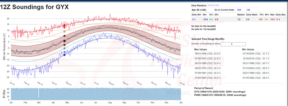
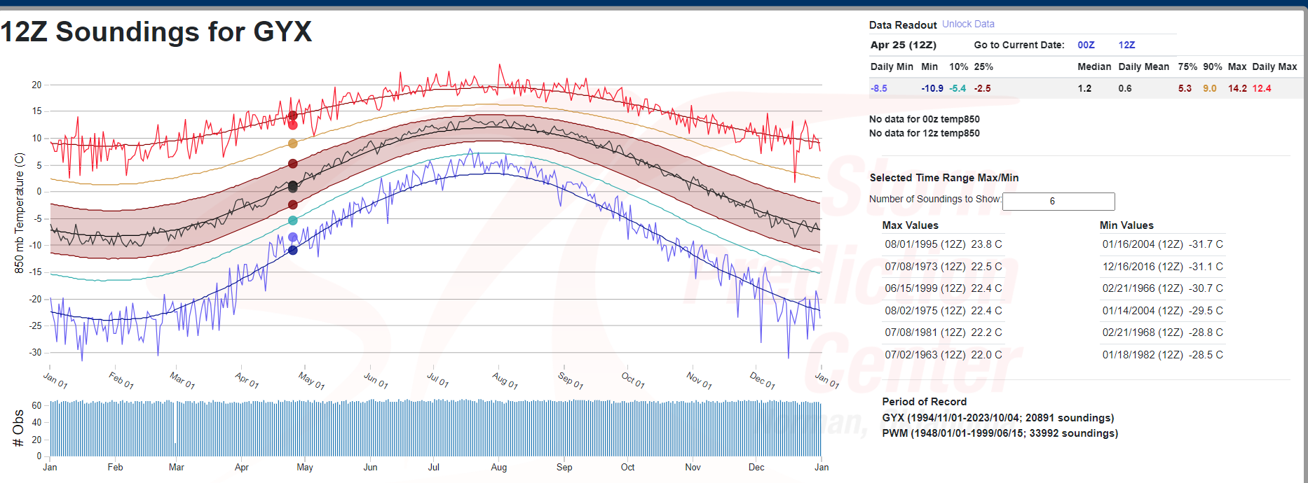
Has to be close to record territory for late April verbatim .. -12 to -16 at 850 is absurd so late.
I'm sure it modifies but still that was an impressive run.
Here is GYX for that date...verbatim would fall a bit short of the record it looks like.
-
1
-
-
We'll see what happens with that. I'd hold a bit of skepticism right now. It's not a typical frontal system dropping south and east across the northern Plains or upper-Midwest.
But this is where the feature in question is currently located.
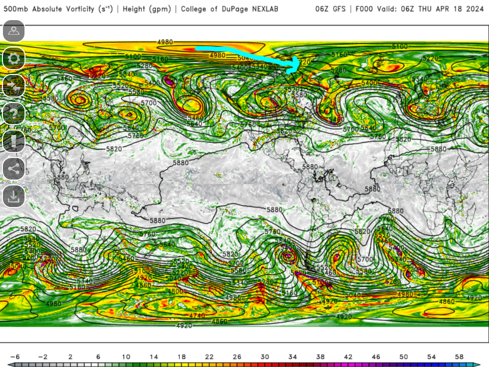
Becomes pretty vigorous and then a piece breaks off and is ejected across our northern areas.
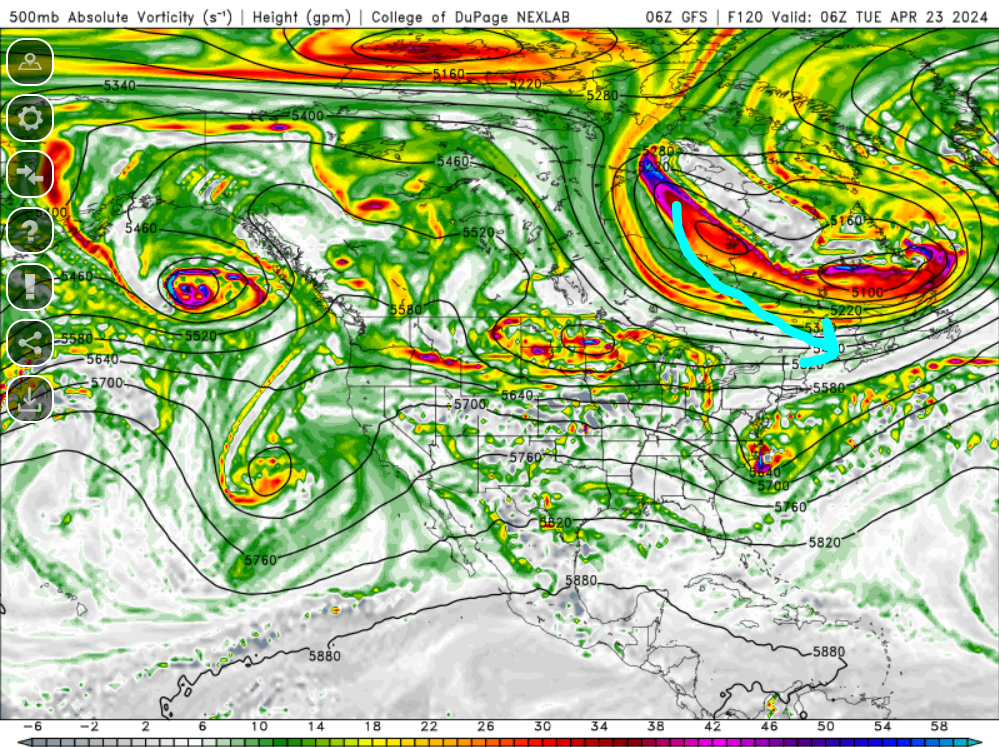
If this doesn't work out it will be much warmer than advertised.
-
2 minutes ago, Typhoon Tip said:
It'll go 7 games because of the two 0Ts the B's lost to make that happen
") ...after giving up the tying goal with 30 sec left in regulation, too -
...after giving up the tying goal with 30 sec left in regulation, too -
I expect any B's playoff series to go 7 games

they seem to love them.
-
12 hours ago, kdxken said:
Torch!
The only leaf blow out that matters these next few weeks are the ones from Toronto getting blown out of the playoffs.
-
4
-
-
It's freezing. Had to wear thermal socks today. booooooo
-
 1
1
-
-
Time to start looking at CAPE maps not snow maps lol
-
 2
2
-
-
The only frost or freeze I want right now is on my beer mug when I put it in the freezer
-
1
-
 1
1
-
-
Well the end of the GFS run is getting into May. Just a few weeks away from getting serious about convective/severe monitoring
-
1
-
2
-
 1
1
-
-
56 minutes ago, Damage In Tolland said:
We tan
pics

-
2
-
1
-
-
What a day...top 5 material...hell maybe even top 3.
-
1
-
-
0z run of the GFS tonight will get into 0z May 1!!!!!
-
THUNDER!!!!!!!!!!!!
-
1
-
-
14 minutes ago, Modfan2 said:
Maybe closer to the NY line
Yup
-
Still looks solid for a few localized damaging wind gusts early this evening within western sections.
-
1 hour ago, Damage In Tolland said:
Looks like some solid bangers mid/ late afternoon tomorrow. Early start to the season
Thread made.
@dendrite pin the severe thread
-
1
-
1
-
-
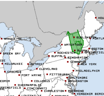
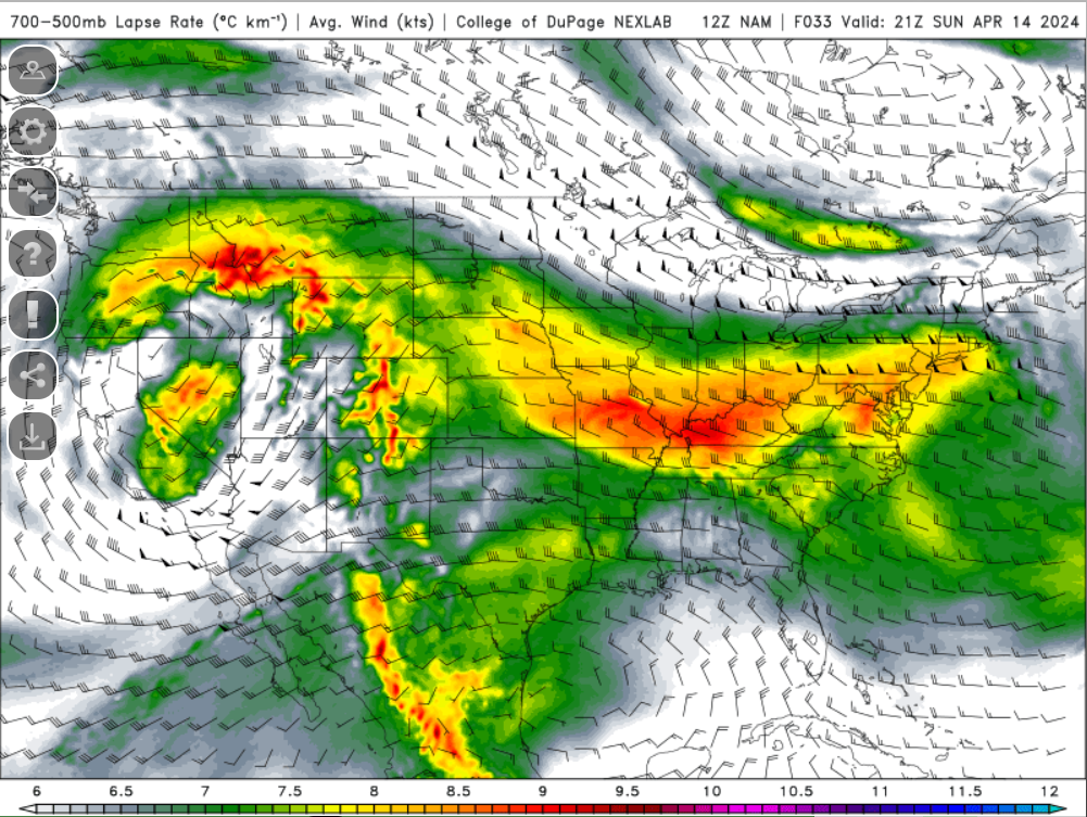
We are still just about 2.5 weeks away from the official start of our severe weather season, but that doesn't mean we can't get severe weather before then. The greatest overall potential is to the west of our region where the Storm Prediction Center has an enhanced risk in place for the potential of damaging wind gusts. A marginal risk for severe weather extends to the I-91 corridor across Massachusetts and Connecticut.
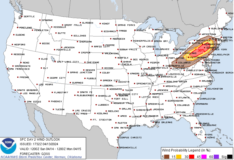
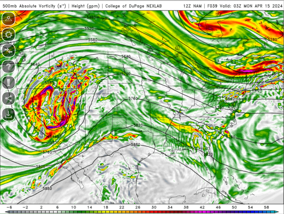
Anyways, the most impressive element Sunday will the advection of very steep mid-level lapse rates:

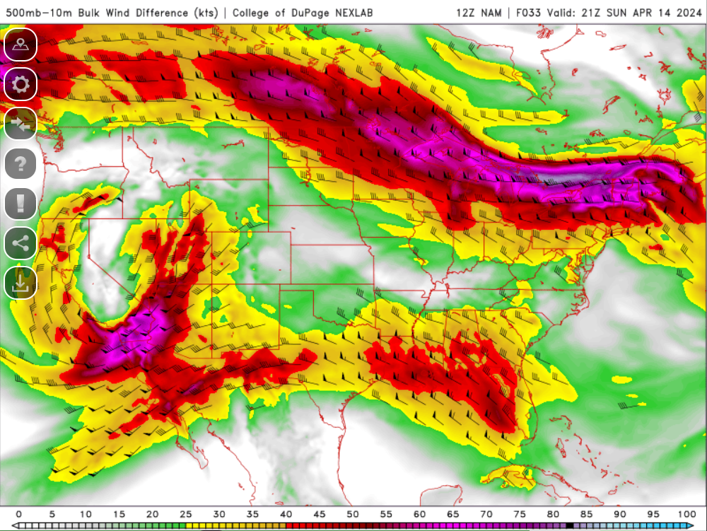
Shear will be impressive with 40-50+ knots of bulk shear overspreading the region
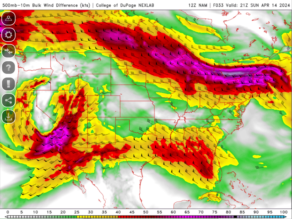
Unfortunately, despite the presence of very steep mid-level lapse rates, surface temperatures only into the 60's with dewpoints into the 40's (maybe climbing into the lower 50's late) will hold back on instability potential and instability will be marginal at best. Also, while we have impressive shortwave energy and shortwave trough digging into the region, this does lag the sfc cold front so the best forcing will be a bit displaced:
What can we expect?
A line of heavy rain and embedded thunder should move across the region, particularly across western areas during the late afternoon and early evening
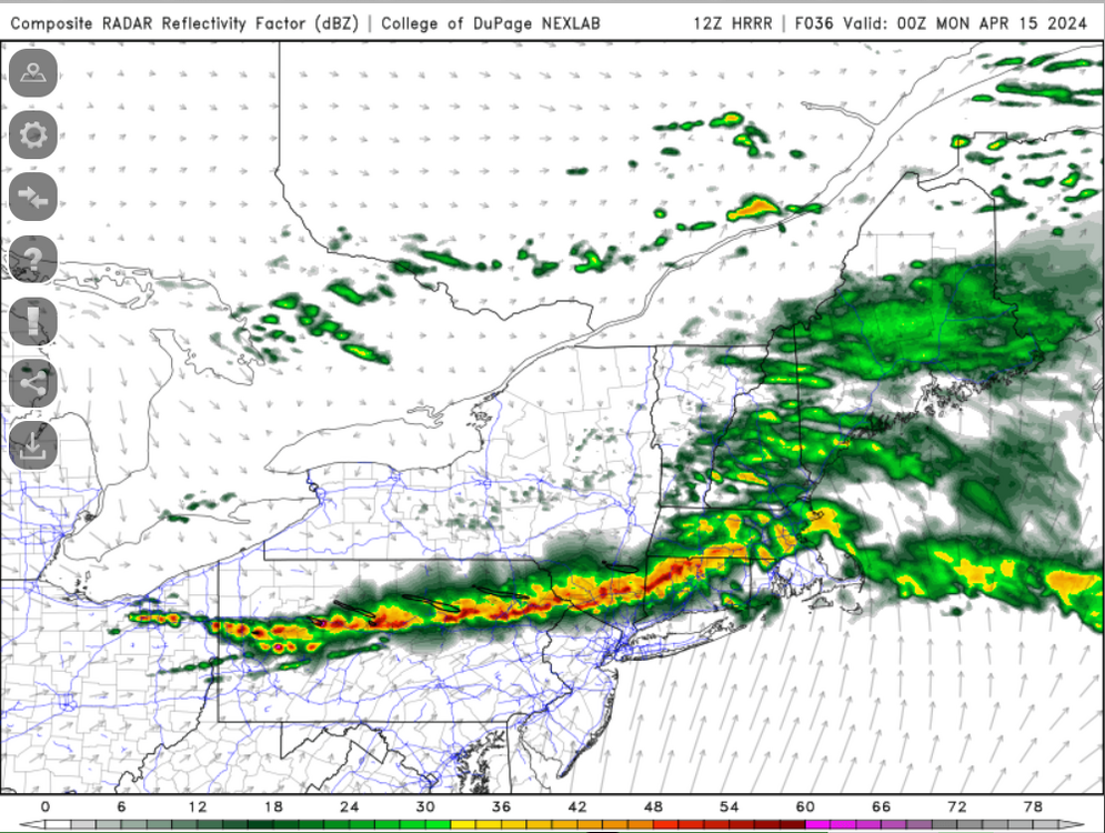
Combination of steep lapse rates, strong winds aloft, and a bit of an inverted V look will promote the potential for some localized damaging wind gusts within the line

-
2
-
1
-
-
Being tickled by a marginal risk
-
1
-
1
-
-
3 minutes ago, Modfan2 said:
Define humid?
65+
-
2 minutes ago, mreaves said:
Can we get through an entire month of spring first?
No
-
1
-


April 2024 Disco- SNE’s favorite month
in New England
Posted
It really isn't bad out. It's great under the Sun with little breeze. Can't wait for it to be 30-40F warmer though with dewpoints 60-70F higher but soon enough.