

weatherwiz
-
Posts
76,468 -
Joined
-
Last visited
Content Type
Profiles
Blogs
Forums
American Weather
Media Demo
Store
Gallery
Posts posted by weatherwiz
-
-
Just now, Chrisrotary12 said:
Cell near Waterbury headed west of Hartford is decent.
probably producing hail west of Bristol
-
ughhh I think it has ticked east a bit...maybe be along the NY/CT border. well at least we'll start seeing more pop
-
5 minutes ago, Torch Tiger said:
VG/VG+ job thus far from mesos, clearly hit the 19-23z for west/central. it's just too bad everything looks anemic, shallow. ":/
poor mlvl lapse rates and the forcing still too far west. I'm wondering if maybe the pre-frontal trough can stay a bit stationary if that can allow for a bit of a boost in a few hours but it probsly shunts east
-
 1
1
-
-
It's headed towards Springfield and I'm in Branford

-
1 minute ago, Torch Tiger said:
svr warning for that E NY/W MA cell.
right on cue
-
Just now, Typhoon Tip said:
The taconic hills with their 2000' ridge lines ?
ifthat sucker can strengthen that may become a supercell
-
 1
1
-
-
I'd watch that cell headed towards NW CT
-
 1
1
-
-
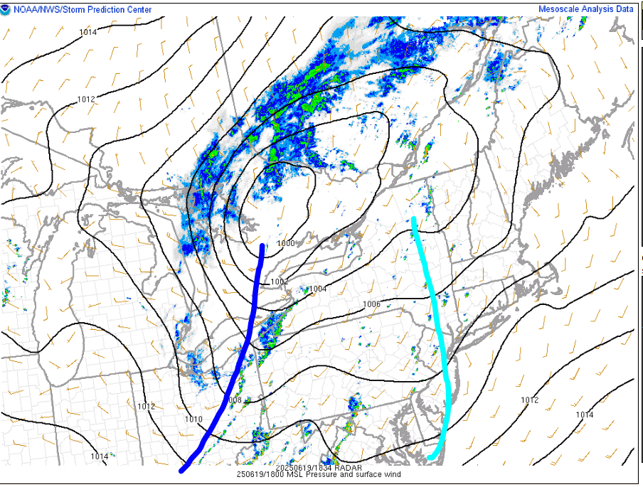
Curious to see what happens between 3-6 PM. The forcing is still pretty west and even seems a few hours slower than what was modeled. But dynamics are increasing a bit and we're backing the sfc winds somewhat, at least locally. The pre-frontal trough is pretty east though...once that goes through maybe we can keep enough instability for some scattered stuff with the front early in the evening
-
1 minute ago, Typhoon Tip said:
I dunno ...
I think the models are overly sensitive ( physics ) to stuff. Typically when you exceed 590 heights in a bona fide ridge node you have suppression... DVM stabilizing ...that's part of the feed-back in the synergistic heat model... some degree ( no pun intended ) of that happens in all warm ridges regardless of whether they go over the top or not.
Anyway, it just seems either the ridge has to pancake some, or these models are going to be wrong with all there junk
That is a very valid point. At the least though, I still think we may see lots of cloud debris from convection across northern Plains into Canada depending on exact flow orientation
-
1 minute ago, Torch Tiger said:
ML lapse rates look like garbage. I get it now, ew
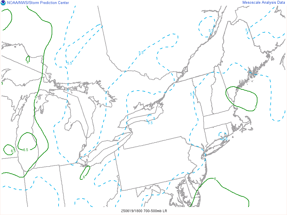
Yeah I was not pleased when I saw that this morning. Maybe the NAM was just overplaying them or maybe the convection from yesterday in the OV region just destroyed the EML plume. Could have got too much of a cold pool with the convection
-
Just now, CoastalWx said:
Euro has the mild down still W-F next week...but then heat returns after. Does look like we trough just before the 4th which may cool things closer to normal. However that is way out.
Next week going to be convectively active and lots of clouds/convective debris around.
-
damn I had lapse rates up on mesoanalysis and saw an area of 7 and got excited...then I realized it was 2-6km lapse rates I had up
-
1
-
-
This stuff killing the potential damn
-
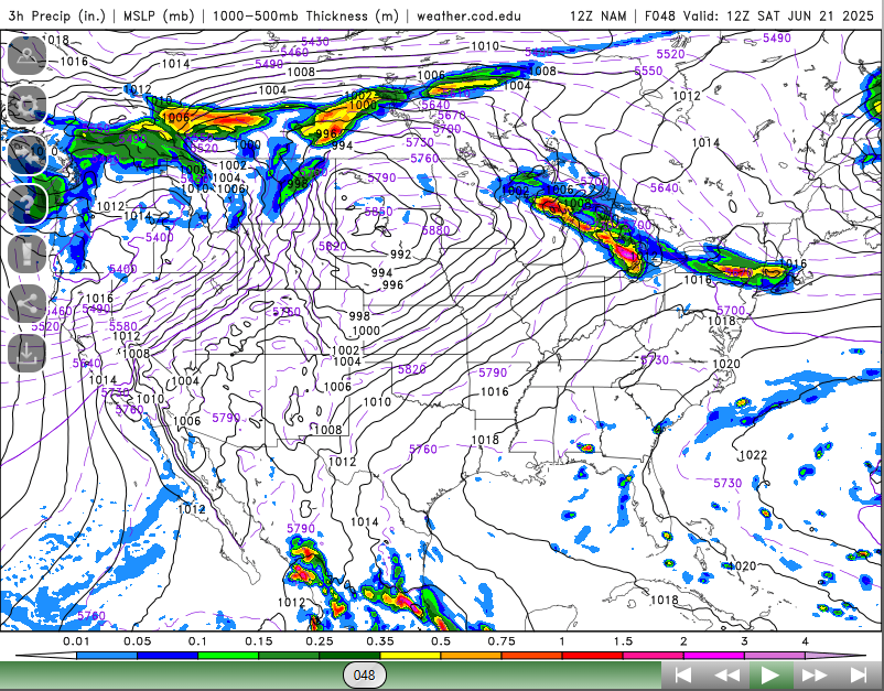
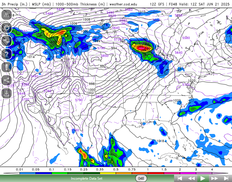
the HRRR is WAYYYYYYYY off
-
RIP to those who didn't listen to Kevin.
-
1
-
 1
1
-
 1
1
-
1
-
-
Nice
-
2 minutes ago, radarman said:
well the 12z 3km gets stuff going earlier out here in W MA and W CT at the expense of the line later on. Goes bonkers with the instability and keeps stuff discrete. Honestly I'm pretty skeptical based on those soundings earlier but look out if it happened to be onto something.
If we had the steep mid-level lapse rates in place I would be pretty concerned with that 3km look. I'm sure we're going to get convection to fire today but it may really struggle to strengthen much...the dynamics will help a bit but its really warm in the mid levels.
-
1 minute ago, radarman said:
decent line through most of CT and W MA mainly south of the pike before falling apart ORH->east
It could be overdone, but it's something
It always intrigues me when the 3km is on the aggressive side b/c more often than not it is meh...and ends up nailing it.
Anyways, 12z observed soundings are kind of garbage...though the BUF sounding shows stronger shear aloft which should overspread western areas later
-
1 minute ago, 40/70 Benchmark said:
There are very varied impacts of volcanic eruptions that are dependent on magnitude and location of said eruption....I read some articules on it after Honga a couple of years ago.
The one other thing I really need to start doing is something like a weekly monitoring/assessment once we enter the Fall. Take some time and assess the real-time global regime, analyze how forecast models are evolving the pattern globally, and closely analyze the medium/long range and then try and do some sort of verification once we get into that time range. I just hope I get time to do this...I start grad school in a few months and doing 2 classes + still working so I am going to have to discipline myself
-
2
-
-
1 minute ago, 40/70 Benchmark said:
I think we are currently in a state of flux, but I don't think the prior regime has been completely "flushed out" quite yet....put it that way.
Anyway, OT here.
Agreed, probably not flushed out quite yet.
One thing I really want to explore though is getting a better understanding of the wildfire smoke and that volcanic eruption from, what a year or two ago and developing much more knowledge of the chemical reactions which occur higher in the atmosphere. I know there must be multiple papers on this so that's where i will start but I have to think these episodes have had a much greater impact and is being overlooked. I mean the abundance of the smoke (assuming its getting into the stratosphere but the water vapor from the eruption)...the concentration of the particles have had to impact how the upper atmosphere structures and evolves.
-
Just now, 40/70 Benchmark said:
Have you started looking at the winter stuff at all?
I'm just getting going...
I plan on doing this shortly. I've been working on composites a bit. I also want to work on a different approach which isn't as ENSO focused...which will help this year given we may be more neutral-ish.
But I was thinking this...we are at a much different atmospheric state across the hemisphere now than we have been over the last several years, particularly across the PAC/CONUS...may not mean anything but we have been saying we need the atmosphere to flush out and maybe this is it!
-
4 minutes ago, WxWatcher007 said:
This seems like a nowcast day. Models are all over the place on both initiation and coverage of convection.
One of my favorite parts of convective forecasting is the nowcasting element!
2 minutes ago, radarman said:tossed
3km nam has consistently done better for convection here so far this year
Yes it has, even elsewhere across the country too. 3km did much better in the midwest yesterday.
-
1
-
-
3 minutes ago, 40/70 Benchmark said:
You are usging this logic on the wrong person.

Was hoping I could sneak it by
2 minutes ago, 40/70 Benchmark said:Anyway, Paul, you have known me long enough to understand I'm just teasing. I do appreciate your entusiasm for weather...savor that because you will probably never witness me admit it again.
Oh I know haha...I don't mind it but it's not as fun if I don't push back a little
")
-
1
-
-
1 minute ago, CoastalWx said:
HRRR says SW CT may have some decent storms. But initiation is sort of varied on models.
I am not sure what to think of with the HRRR...it really struggled in the midwest leading up to yesterday and even during the day.
June 2025 Obs/Disco
in New England
Posted
Yeah we see stuff pop more easily but the trade off is weaker activity. This is why pre-frontal troughs hurt us more often than not...once we get the convective temp reached we start popping too early. This is one reason why those EMLs are so important. they keep a lid on things until the strongest forcing can arrive