

weatherwiz
-
Posts
76,464 -
Joined
-
Last visited
Content Type
Profiles
Blogs
Forums
American Weather
Media Demo
Store
Gallery
Posts posted by weatherwiz
-
-
I'm not a huge fan of temperature anomaly maps. They're useful but terrible for communication purposes.
-
Well hoping we can maybe muster some good convection potential Tuesday. Timing should be more favorable but may have to deal with AM crap/clouds
-
5 hours ago, CoastalWx said:
The 4th looks like the coolest day out of the bunch coming up. Probably near 80 and low dews. Otherwise it’s a summery look. Possibly some 90+ weekend after the 4th. After that we trough again and then as I said yesterday, it looks to retro and open up the door to warmer and more humid weather at the end of the 11-15 day.
yeah we get that weak front moving through end of week with high pressure building in but looks like its a one day ordeal and we flip to very warm/humid for Saturday.
-
Next Saturday should be solidly into the 80's (obviously except immediate coastal probably and the higher elevations) and Saturday night will be into the 60's for lows.
-
5 minutes ago, OceanStWx said:
That's the theory of the case anyway. Instead of pouring resources into multiple models, we can focus all our energy on making the RRFS really good.
Of course the FV3 core was really not great for convection and had to be scrapped. So now we're starting over with MPAS for a core.
In an ideal world you would have the GFS/GEFS for longer range, RRFS/REFS for the inside 60 hours, and WoFS for storm scale, event driven cases.
This would probably help with the idea of "too many tools in the box". There are so many models and data to digest, who really has time to do all of that? If the energy and focus can be spent on a few models to improve assimilation and initialization that would go a substantial way in improving forecast accuracy and confidence.
-
32 minutes ago, FXWX said:
Would not want to lose the HREF...
Was shocked to see that mentioned. Isn't that a "newer product anyways"? I forgot when HREF became operational but I feel like it was at least in the last 10 years?
-
22 minutes ago, MegaMike said:
Embrace the NAM while you can, weenies.
Change is coming.

Interesting. Assuming this could be a big positive in more resources would be available for the RRFS instead of running all these various short-term mesos.
-
8 minutes ago, HoarfrostHubb said:
But seriously, where are the mid 80s in N ORH county for Sunday?
mid 80's may be tough but we will be warming the llvls through the day with a northwesterly flow so probably have to tack on 2-3F to the 2m progs.
-
 1
1
-
-
Timing blows a bit tomorrow but western areas could see some storms during the early evening. Probably see marginal expanded east some with an upgrade to a slight risk in there
-
7 minutes ago, Typhoon Tip said:
Saturday could sneakily become a low risk severe day ...
I think I see what's been going on - and the Euro may have been superior in this regard. The flow's more progressive, and the high that is passing N of the region through tomorrow, is faster moving off S of the Maritime in the prior Euro runs than the GFS, which in delaying that departure ...yeah, it's mass fields are holding damming in longer...
This 12z GFS run inched a little N with the warm front again - now between the Pike and Rt 2 at 18z. Two runs ago it was near NYC
But here's the thing, the Euro's front was ironically slower, and the GFS is now faster with the trailing cold front. I don't think the lapse rates are good given this ( but haven't seen soundings...) but when you dawn with warm front escape, then have a cool boundary into western zones later in the day, that's a typical severe set up - in principle. There's also a right exit--> entrance relay as a 500 mb S/W perturbation moves through NNE in the afternoon.
Sure could be! I was thinking about you when I was looking at that earlier haha. I knew you would provide some in depth analysis on this.
Good call Kevin yesterday
-
Actually I wonder if Berkshire County could get some strong storms late Sat afternoon or early evening
-
1
-
-
Tuesday could be a fun day...start of NHL free agency and maybe some strong storms!
-
2
-
-
Hoping Friday evening is dry (should be). May do a fire and round 1 of the NHL draft outside. Will be a perfect evening for a fire though I’d prefer the 100/73.
-
 1
1
-
-
Just now, kevin1927 said:
I know wth.
jet exhaust

-
1
-
 1
1
-
-
1 minute ago, kevin1927 said:
Boston shot back up to 95 now lol.
on an E win at 14 mph?
-
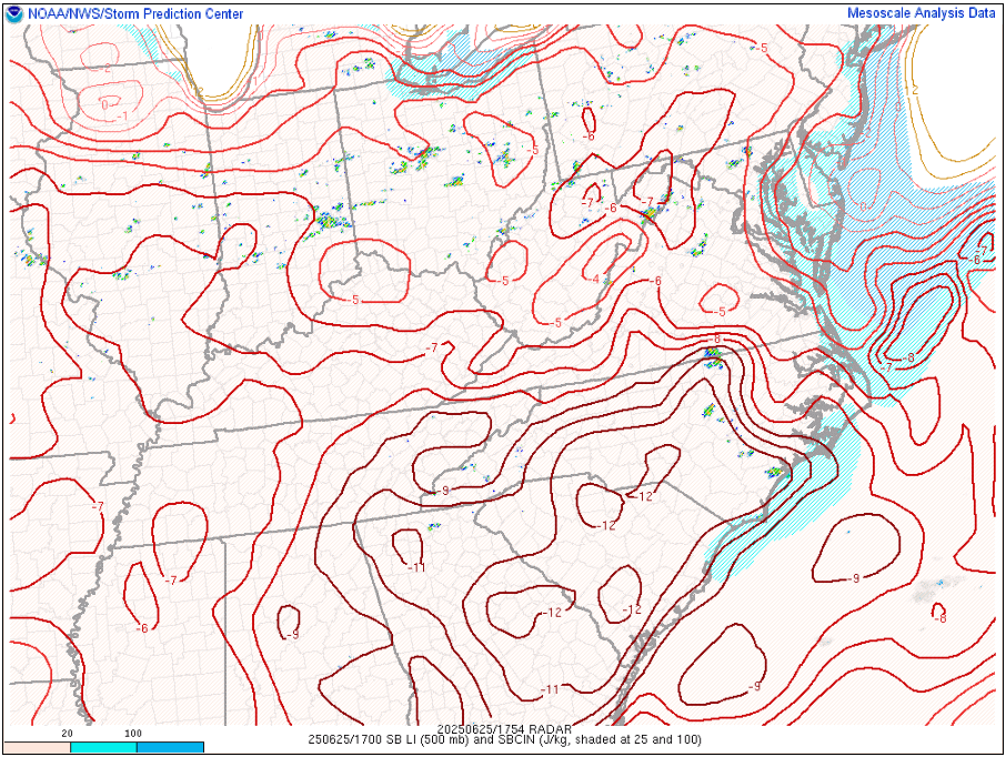
LIs of -12C in the Carolinas into Georgia!!!!
-
 1
1
-
-
hate seeing these depressing posts
-
4 minutes ago, Damage In Tolland said:
Not on the Euro
It looks like the euro wants to retreat the stationary front through as a warm front with cold front siding later. I wish the euro was right but don't really see any means for that occurring. Would like to see some sort of strengthening sfc low passing to our north and west
-
yeah Saturday blows
-
2
-
 1
1
-
-
10 minutes ago, dendrite said:
Bye bye dews soon...at least for a little while.
They're going to recharge and come back with a vengeance and then there will be no escape.
-
1
-
 1
1
-
-
29 minutes ago, Brian5671 said:
12Z run pushes the rain S and W of New England
still some differences on how far southwest front pushes and where it stalls.
-
Just saw EWR only got down to 85 last night...that's wild
-
5 minutes ago, dendrite said:
12z HRRR is quite a bit wetter down there4.
yeah I was noticing that. Looks kind of anafront-ish like?
-
3 minutes ago, CoastalWx said:
Yeah agree
There are certain setups in which the 3km can get too happy with precipitation development
July 2025 Obs/Disco ... possible historic month for heat
in New England
Posted
I like the shear, just have to destabilize sufficiently.