

weatherwiz
-
Posts
76,506 -
Joined
-
Last visited
Content Type
Profiles
Blogs
Forums
American Weather
Media Demo
Store
Gallery
Everything posted by weatherwiz
-

July 2025 Obs/Disco ... possible historic month for heat
weatherwiz replied to Typhoon Tip's topic in New England
Looks like we should be solidly above average, even behind any FROPAs...the only thing we'll noticeably have is a brief period of lower dews. People could call this cheap or whatever because it could be alot of 90/91's but some of the typical torch spots will have a good shot to rack up some 90's over the next few weeks. A quick glimpse of the pattern too should yield hope for MCS potential but we probably get screwed and everything goes from northern Plains, upper-Midwest, Ohio Valley -
July 2025 Obs/Disco ... possible historic month for heat
weatherwiz replied to Typhoon Tip's topic in New England
what a supercell in far northwestern Maine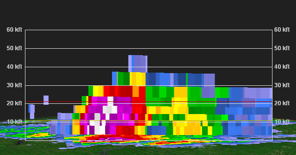
-
July 2025 Obs/Disco ... possible historic month for heat
weatherwiz replied to Typhoon Tip's topic in New England
Is this like a weak pre-frontal trough or something? Looks like it on WV or some weak embedded shortwave trough ahead of the larger s/w trough -
July 2025 Obs/Disco ... possible historic month for heat
weatherwiz replied to Typhoon Tip's topic in New England
I wonder if we get a bit of shortwave subsidence? Maybe thats why some of these HRRR runs and latest 3km are meh. -
July 2025 Obs/Disco ... possible historic month for heat
weatherwiz replied to Typhoon Tip's topic in New England
I'd watch closely. It looks like there is some sort of boundary across Connecticut...south-central Connecticut -
July 2025 Obs/Disco ... possible historic month for heat
weatherwiz replied to Typhoon Tip's topic in New England
Anyone think Costco's will be open tomorrow? Want to try and go chasing after work but I need to go to Costco -
July 2025 Obs/Disco ... possible historic month for heat
weatherwiz replied to Typhoon Tip's topic in New England
Think its safe to toss the HRRR -
July 2025 Obs/Disco ... possible historic month for heat
weatherwiz replied to Typhoon Tip's topic in New England
This could also scale back the upper end of heat potential Monday -
July 2025 Obs/Disco ... possible historic month for heat
weatherwiz replied to Typhoon Tip's topic in New England
HRRR seems wonky with the dews...wonder if thats why? -
July 2025 Obs/Disco ... possible historic month for heat
weatherwiz replied to Typhoon Tip's topic in New England
Connecticut (particularly along and southeast of 84) and Rhode Island should be prime today -
July 2025 Obs/Disco ... possible historic month for heat
weatherwiz replied to Typhoon Tip's topic in New England
Not entirely shocked at the slight risk designation. We've had some worse setups get a slight risk designation That is a really well-defined s/w trough moving into the region with good height fields and increasing dynamics with cooling aloft. I would be shocked if storms aren't numerous tomorrow and evolve into multiple short-line segments or clusters -
July 2025 Obs/Disco ... possible historic month for heat
weatherwiz replied to Typhoon Tip's topic in New England
maybe! -
July 2025 Obs/Disco ... possible historic month for heat
weatherwiz replied to Typhoon Tip's topic in New England
the is one strong shortwave digging through tomorrow for early July. Convection (CONVECTION NOT SEVERE) should overperform. Thought maybe convergence could be a little meh but it doesn't seem bad. What we really need to watch are dews...if we can pool dews another 3-4F that would make things a bit more interesting for some localized severe weather. -
July 2025 Obs/Disco ... possible historic month for heat
weatherwiz replied to Typhoon Tip's topic in New England
Yup…don’t see that too terribly often here. Cool to see -
July 2025 Obs/Disco ... possible historic month for heat
weatherwiz replied to Typhoon Tip's topic in New England
animated.mov -
July 2025 Obs/Disco ... possible historic month for heat
weatherwiz replied to Typhoon Tip's topic in New England
Brother lives in new Britain and lighting hit something about 1/10th of a mile from his house -
July 2025 Obs/Disco ... possible historic month for heat
weatherwiz replied to Typhoon Tip's topic in New England
Those storms exploded along the outflow -
July 2025 Obs/Disco ... possible historic month for heat
weatherwiz replied to Typhoon Tip's topic in New England
Surprised at the 1” hail tag. Tough to get 1” hail in this setup. Poor lapse rates and very warm aloft. Would need a monster updraft to achieve that. -
July 2025 Obs/Disco ... possible historic month for heat
weatherwiz replied to Typhoon Tip's topic in New England
And it gets warned -
July 2025 Obs/Disco ... possible historic month for heat
weatherwiz replied to Typhoon Tip's topic in New England
Quite breezy out ahead of this -
July 2025 Obs/Disco ... possible historic month for heat
weatherwiz replied to Typhoon Tip's topic in New England
Also looks like some dewpoint pooling ongoing with a theta-e ridge overhead. MLCAPE ~2000 not bad given the poor mid-level lapse rates. Any severe risk though should be extremely localized. DCAPE is meh with pretty poor 2-6km lapse rates and llvl shear is not much. So just going to be some torrential rain (poor drainage flooding risk) and maybe some good CGs -
July 2025 Obs/Disco ... possible historic month for heat
weatherwiz replied to Typhoon Tip's topic in New England
It is! Seems to be evolving nicely. Satellite shows great upscale growth with cooling cloud tops. Might even be a weak sea breeze front which aids in development within south-central CT. -
July 2025 Obs/Disco ... possible historic month for heat
weatherwiz replied to Typhoon Tip's topic in New England
Not saying we see much severe but we may see a pretty solid line of torrential rain and thunderstorms evolve right along the 84 corridor. -
July 2025 Obs/Disco ... possible historic month for heat
weatherwiz replied to Typhoon Tip's topic in New England
short term trends looking favorable from about MA Pike into norther CT in a few hours -
July 2025 Obs/Disco ... possible historic month for heat
weatherwiz replied to Typhoon Tip's topic in New England
Only limiting factors I see towards greater coverage are the "lower dewpoints" - 60's aren't bad but would like to see like 68-70+ and llvl convergence looks a little weak. Anyways, steep lapse rates aloft and good height falls so can't sleep on it


