

weatherwiz
-
Posts
81,341 -
Joined
-
Last visited
Content Type
Profiles
Blogs
Forums
American Weather
Media Demo
Store
Gallery
Everything posted by weatherwiz
-

Augdewst 2026: Summer's Last Stand
weatherwiz replied to Prismshine Productions's topic in New England
The big difference in this versus the previous setups is this rain isn't spread out over a long duration. This will be the type of stuff that produces 2-4" in 1-2 hours versus several-plus hours. -
Augdewst 2026: Summer's Last Stand
weatherwiz replied to Prismshine Productions's topic in New England
Rainfall rates will be quite impressive tomorrow and the initial round of rain is going to be on the widespread side and then we see what we can develop during the day in terms of convection. You have a stout southerly LLJ into the region with 8850 dewpoints +16 to +17C and PWAT values between 2.20" and 2.40". There is no capping and you have the LFC right about the same height as the LCL. The radar is going to be lit up with rain and continuous development of downpours and embedded thunder throughout the day and this will train across a large area. -
Augdewst 2026: Summer's Last Stand
weatherwiz replied to Prismshine Productions's topic in New England
I'm shocked there aren't flash flood watches out or flood watches. I bet tonight into tomorrow evening has more reports of flooding than the past few setups combined. -
Not a bad looking core. Surprised at least no SPS on it
-
Thundering here!!!!
-
I'd actually be shocked if the ICON wasn't
-
Augdewst 2026: Summer's Last Stand
weatherwiz replied to Prismshine Productions's topic in New England
Pretty classic wet microburst look on soundings if we can get anything to materialize -
Looks like a typical GFS fantasy storm
-
Great stuff, are all these plots from the University of Miami. I love these wind shear/instability plots
-
I was doing some digging last week and some of the extended guidance seemed to want and relax wind shear across the MDR a bit, however, I wasn't particularly sold and was wondering if that was a product of guidance in the extended favoring climo and wanting to decrease shear as we get closer to peak climo. Waters in the MDR are also pretty meh. Will continue to be a focus for home brew, especially as we start getting more active with fronts.
-
Water temperatures are way too cold once you quickly get north of NC and there will be a lot of upwelling early next week. You would need probably a high end 3 or 4 approaching the Carolina coast and rapidly accelerate northward to get a cane hit here. Otherwise any system is would transition to extra-tropical or sub-tropical extremely quickly.
-
Yup...have to see exactly how quickly the front moves and where it stalls. Just based off the look its possible GFS may be a bit too fast with it...although the 6z GFS might be hedging towards something I'd lean towards. But that is a stout LLJ with PWATS well over 2" region-wide.
-
Yup. That's a setup to where you have to worry about flash flooding being a concern over a greater area.
-
wow
-
McDonalds overall is awful now...not that it was ever particularly great but its extremely overpriced and significantly worse quality. Can let to to like Applebees or Chilis and get a better burger dinner for only a few extra bucks. The McDonalds across from BDL isn't bad though. Had a double quarter pounder from there not long back and it was great.
-
Now you have me craving that. Haven't had one of those in a while.
-
Dumping here in Windsor. Was hoping we could get a lightning strike out of this
-
Yes, but that was within the area of where the highest potential for the greatest rainfall totals. Serious stuff there but rather localized and confined to one area. Basically a much needed rain for everyone with little flooding outside of some usual areas in Fairfield County around Bridgeport.
-
Very slow moving cold front becoming parallel to the upper flow and potential for a wave to develop along it. Deep southerly flow out ahead of it so a continuous fetch of moisture. See what happens but these is how you can get widespread 3-4" rain amounts and get those areas of 6-7"+
-
Now Sunday into Monday is something that can be a legit flash flood concern
-
I think mosquitos have evolved to the point to where they don't care anymore. As long as its above 50 they will be out looking for blood. Dry conditions, humid conditions, don't matter to them anymore
-
Was intrigued in potential for a strong or two within CT today should anything pop but I wonder if there is a window early afternoon for a localized damaging wind gust or brief tornado across SE MA.
-
An flooding yet outside of some random Bridgeport roads where the drains are clogged from McDonalds wrappers and bullet shell casings?
-
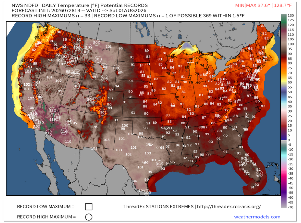
That's some serious heat for the desert Southwest later this week
-
Just dropping by to add this


